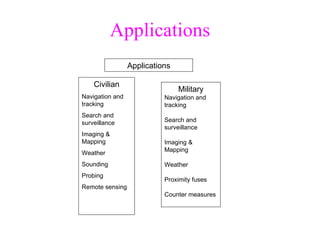
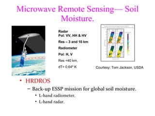
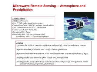
SlideShare a Scribd company logo
Microwave Remote Sensing
History ,[object Object],[object Object],[object Object],[object Object],[object Object]
History ,[object Object],[object Object],[object Object],[object Object],[object Object],[object Object],[object Object],[object Object],[object Object]
Applications Applications Civilian Navigation and tracking Search and surveillance Imaging & Mapping Weather  Sounding Probing Remote sensing Military Navigation and tracking Search and surveillance Imaging & Mapping Weather Proximity fuses Counter measures
Microwave scattering ,[object Object],[object Object],[object Object],[object Object],[object Object],Smooth surface Moderately rough surface Very rough surface θ i θ r
Microwave scattering ,[object Object]
Microwave Scattering ,[object Object],[object Object],[object Object],[object Object],[object Object],[object Object]
Microwave Scattering ,[object Object],[object Object],[object Object],[object Object],[object Object],[object Object],[object Object],[object Object]
Microwave Remote Sensing ,[object Object],[object Object],[object Object],[object Object],r
Radar Equation For a distributed  power received falls off as 1/R 2 For a point target power received falls off as 1/R 4
Microwave Remote Sensing— Atmosphere and Precipitation ,[object Object],[object Object],[object Object],[object Object],[object Object],[object Object],[object Object],[object Object]
Microwave Remote Sensing ,[object Object],[object Object],[object Object],[object Object],[object Object]
Microwave Remote Sensing— Ocean and Ice ,[object Object],[object Object],[object Object],[object Object],[object Object],[object Object],[object Object],[object Object],[object Object],[object Object]
Ocean Vector Winds— Scatterometers ,[object Object],[object Object],[object Object],[object Object],[object Object],[object Object],[object Object],[object Object],Scatterometers send microwave pulses to the  Earth's surface, and measure the power scattered  back.  Backscattered power over the oceans  depends on the surface roughness, which in turn  depends on wind speed and direction. QuikScat SeaWinds Advanced sensors– larger aperture antennas.Passive polarimetric sensors.
Ocean Topography Missions ,[object Object],[object Object],[object Object],[object Object],[object Object],[object Object],[object Object],[object Object],[object Object],[object Object],The most effective measurement of ocean currents  from space is ocean topography, the height of the sea surface above a surface of uniform gravity, the geoid. The priority is to continue the measurement  with TOPEX/Poseidon accuracy   on a long-term basis for climate studies. 
Microwave Remote Sensing— Soil Moisture. ,[object Object],[object Object],[object Object],[object Object],Courtesy: Tom Jackson, USDA SGP’97 Radar Pol: VV, HH & HV Res – 3 and 10 km Radiometer Pol: H, V Res =40 km,  dT= 0.64º K
Salient Features NASA ESSP mission First 94 GHz radar space borne system Co-manifested with CALIPSO on Delta launch vehicle Flies Formation with the EOS Constellation Current launch date: April 2004 Operational life: 2 years Partnership with DoD (on-orbit ops), DoE (validation) and CSA (radar development) Science Measure the vertical structure of clouds and quantify their ice and water content Improve weather prediction and clarify climatic processes. Improve cloud information from other satellite systems, in particular those of Aqua Investigate the way aerosols affect clouds and precipitation Investigate the utility of 94 GHz radar to observe and quantify precipitation, in the context of cloud properties, from space Microwave Remote Sensing— Atmosphere and Precipitation
The End ,[object Object]

More Related Content

What's hot

Scale and resolution
Scale and resolutionScale and resolution
Scale and resolution
shabir dar
 
Fundamentals of Remote Sensing
Fundamentals of Remote SensingFundamentals of Remote Sensing
Fundamentals of Remote Sensing
Shah Naseer
 
.remote sensing.Ece 402 unit-2
.remote sensing.Ece 402 unit-2.remote sensing.Ece 402 unit-2
.remote sensing.Ece 402 unit-2
Vandana Verma
 
Digital elevation model in GIS
Digital elevation model in GISDigital elevation model in GIS
Digital elevation model in GIS
Prof. A.Balasubramanian
 
Remote sensing & Radiometers Systems
Remote sensing & Radiometers Systems Remote sensing & Radiometers Systems
Remote sensing & Radiometers Systems
Jay Baria
 
Introduction to Landsat
Introduction to LandsatIntroduction to Landsat
Introduction to Landsat
Nizam GIS
 
Indian remote sensing satellites
Indian remote sensing satellitesIndian remote sensing satellites
Indian remote sensing satellites
Hiba Shahid
 
GIS Plateform and satellite
GIS Plateform and satelliteGIS Plateform and satellite
GIS Plateform and satellite
Mohsin Siddique
 
Radar remote sensing, P K MANI
Radar remote sensing, P K MANIRadar remote sensing, P K MANI
Radar remote sensing, P K MANI
P.K. Mani
 
Thermal remote sensing and its applications
Thermal remote sensing and its applicationsThermal remote sensing and its applications
Thermal remote sensing and its applications
chandan00781
 
Introduction to Remote Sensing
Introduction to Remote SensingIntroduction to Remote Sensing
Introduction to Remote Sensing
Malla Reddy University
 
Spectral signature and spectral libraries
Spectral signature and spectral librariesSpectral signature and spectral libraries
Spectral signature and spectral libraries
Sheikh Maryam
 
Remote sensing-presentaion
Remote sensing-presentaionRemote sensing-presentaion
Remote sensing-presentaion
Mouna Guru
 
Remote Sensing - Fundamentals
Remote Sensing - FundamentalsRemote Sensing - Fundamentals
Remote Sensing - Fundamentals
Ajay Singh Lodhi
 
INTRODUCTION TO REMOTE SENSING
 INTRODUCTION TO REMOTE SENSING INTRODUCTION TO REMOTE SENSING
INTRODUCTION TO REMOTE SENSING
Ghassan Hadi
 
Spot satellite
Spot satelliteSpot satellite
Spot satellite
titus chapukira
 
GPS HISTORY
GPS HISTORYGPS HISTORY
GPS HISTORY
BANKURA UNIVERSITY
 

What's hot (20)

Scale and resolution
Scale and resolutionScale and resolution
Scale and resolution
 
Fundamentals of Remote Sensing
Fundamentals of Remote SensingFundamentals of Remote Sensing
Fundamentals of Remote Sensing
 
.remote sensing.Ece 402 unit-2
.remote sensing.Ece 402 unit-2.remote sensing.Ece 402 unit-2
.remote sensing.Ece 402 unit-2
 
Digital elevation model in GIS
Digital elevation model in GISDigital elevation model in GIS
Digital elevation model in GIS
 
Ikonos
IkonosIkonos
Ikonos
 
Remote sensing & Radiometers Systems
Remote sensing & Radiometers Systems Remote sensing & Radiometers Systems
Remote sensing & Radiometers Systems
 
Introduction to Landsat
Introduction to LandsatIntroduction to Landsat
Introduction to Landsat
 
Indian remote sensing satellites
Indian remote sensing satellitesIndian remote sensing satellites
Indian remote sensing satellites
 
GIS Plateform and satellite
GIS Plateform and satelliteGIS Plateform and satellite
GIS Plateform and satellite
 
Radar remote sensing, P K MANI
Radar remote sensing, P K MANIRadar remote sensing, P K MANI
Radar remote sensing, P K MANI
 
Thermal remote sensing and its applications
Thermal remote sensing and its applicationsThermal remote sensing and its applications
Thermal remote sensing and its applications
 
SPOT
SPOTSPOT
SPOT
 
Introduction to Remote Sensing
Introduction to Remote SensingIntroduction to Remote Sensing
Introduction to Remote Sensing
 
Spectral signature and spectral libraries
Spectral signature and spectral librariesSpectral signature and spectral libraries
Spectral signature and spectral libraries
 
Remote sensing-presentaion
Remote sensing-presentaionRemote sensing-presentaion
Remote sensing-presentaion
 
DTM
DTMDTM
DTM
 
Remote Sensing - Fundamentals
Remote Sensing - FundamentalsRemote Sensing - Fundamentals
Remote Sensing - Fundamentals
 
INTRODUCTION TO REMOTE SENSING
 INTRODUCTION TO REMOTE SENSING INTRODUCTION TO REMOTE SENSING
INTRODUCTION TO REMOTE SENSING
 
Spot satellite
Spot satelliteSpot satellite
Spot satellite
 
GPS HISTORY
GPS HISTORYGPS HISTORY
GPS HISTORY
 

Viewers also liked

Microwave remote sensing
Microwave remote sensingMicrowave remote sensing
Microwave remote sensing
Mohsin Siddique
 
Thermal remote sensing BY Hariom Ahlawat
Thermal remote sensing BY Hariom AhlawatThermal remote sensing BY Hariom Ahlawat
Thermal remote sensing BY Hariom Ahlawat
Hariom Ahlawat
 
Thermal Remote Sensing
Thermal Remote SensingThermal Remote Sensing
Thermal Remote Sensing
Rohit Kumar
 
Remote Sensing PPT
Remote Sensing PPTRemote Sensing PPT
Remote Sensing PPT
Amal Murali
 
Thermal remote sensing
Thermal remote sensing   Thermal remote sensing
Thermal remote sensing
Rahat Malik
 
Remote sensing and image interpretation
Remote sensing and image interpretationRemote sensing and image interpretation
Remote sensing and image interpretation
Md. Nazir Hossain
 
Application of Remote Sensing in Agriculture
Application of Remote Sensing in AgricultureApplication of Remote Sensing in Agriculture
Application of Remote Sensing in Agriculture
UTTAM KUMAR
 
Optical and Microwave Remote Sensing for Crop Monitoring in Mexico
Optical and Microwave Remote Sensing for Crop Monitoring in MexicoOptical and Microwave Remote Sensing for Crop Monitoring in Mexico
Optical and Microwave Remote Sensing for Crop Monitoring in Mexico
CIMMYT
 
Remote sensing and application by Nikhil Pakwanne
Remote sensing and application by Nikhil PakwanneRemote sensing and application by Nikhil Pakwanne
Remote sensing and application by Nikhil PakwanneNIKHIL PAKWANNE
 
The active remote sensing equation
The active remote sensing equationThe active remote sensing equation
The active remote sensing equation
tobiasotto
 
Agriculture drought with remote sensing
Agriculture drought with remote sensingAgriculture drought with remote sensing
Agriculture drought with remote sensing
Institute of Space Knowledge Development
 
Lecture 1-aerial photogrammetry
Lecture 1-aerial photogrammetryLecture 1-aerial photogrammetry
Lecture 1-aerial photogrammetry
Vidhi Khokhani
 
REMOTE SENSING
REMOTE SENSINGREMOTE SENSING
REMOTE SENSING
KANNAN
 
Basic of Remote Sensing
Basic of Remote SensingBasic of Remote Sensing
Basic of Remote Sensing
gueste5cfed
 
Principle of FMCW radar
Principle of FMCW radarPrinciple of FMCW radar
Principle of FMCW radar
tobiasotto
 
Surface Soil Moisture and Groundwater Assessment and Monitoring using Remote ...
Surface Soil Moisture and Groundwater Assessment and Monitoring using Remote ...Surface Soil Moisture and Groundwater Assessment and Monitoring using Remote ...
Surface Soil Moisture and Groundwater Assessment and Monitoring using Remote ...
Jenkins Macedo
 
Transmission Technology Session
Transmission Technology SessionTransmission Technology Session
Transmission Technology Session
Muhammad Yahya
 

Viewers also liked (20)

Microwave remote sensing
Microwave remote sensingMicrowave remote sensing
Microwave remote sensing
 
Thermal remote sensing BY Hariom Ahlawat
Thermal remote sensing BY Hariom AhlawatThermal remote sensing BY Hariom Ahlawat
Thermal remote sensing BY Hariom Ahlawat
 
Thermal Remote Sensing
Thermal Remote SensingThermal Remote Sensing
Thermal Remote Sensing
 
Lecture 23 notes
Lecture 23   notesLecture 23   notes
Lecture 23 notes
 
Remote Sensing PPT
Remote Sensing PPTRemote Sensing PPT
Remote Sensing PPT
 
Thermal remote sensing
Thermal remote sensing   Thermal remote sensing
Thermal remote sensing
 
Remote sensing and image interpretation
Remote sensing and image interpretationRemote sensing and image interpretation
Remote sensing and image interpretation
 
Application of Remote Sensing in Agriculture
Application of Remote Sensing in AgricultureApplication of Remote Sensing in Agriculture
Application of Remote Sensing in Agriculture
 
Optical and Microwave Remote Sensing for Crop Monitoring in Mexico
Optical and Microwave Remote Sensing for Crop Monitoring in MexicoOptical and Microwave Remote Sensing for Crop Monitoring in Mexico
Optical and Microwave Remote Sensing for Crop Monitoring in Mexico
 
LANDSAT
LANDSATLANDSAT
LANDSAT
 
Remote sensing and application by Nikhil Pakwanne
Remote sensing and application by Nikhil PakwanneRemote sensing and application by Nikhil Pakwanne
Remote sensing and application by Nikhil Pakwanne
 
The active remote sensing equation
The active remote sensing equationThe active remote sensing equation
The active remote sensing equation
 
remote sensing
remote sensingremote sensing
remote sensing
 
Agriculture drought with remote sensing
Agriculture drought with remote sensingAgriculture drought with remote sensing
Agriculture drought with remote sensing
 
Lecture 1-aerial photogrammetry
Lecture 1-aerial photogrammetryLecture 1-aerial photogrammetry
Lecture 1-aerial photogrammetry
 
REMOTE SENSING
REMOTE SENSINGREMOTE SENSING
REMOTE SENSING
 
Basic of Remote Sensing
Basic of Remote SensingBasic of Remote Sensing
Basic of Remote Sensing
 
Principle of FMCW radar
Principle of FMCW radarPrinciple of FMCW radar
Principle of FMCW radar
 
Surface Soil Moisture and Groundwater Assessment and Monitoring using Remote ...
Surface Soil Moisture and Groundwater Assessment and Monitoring using Remote ...Surface Soil Moisture and Groundwater Assessment and Monitoring using Remote ...
Surface Soil Moisture and Groundwater Assessment and Monitoring using Remote ...
 
Transmission Technology Session
Transmission Technology SessionTransmission Technology Session
Transmission Technology Session
 

Similar to Microwave remote sensing

TU2.L10 - THE AQUARIUS/SAC-D MISSION OVERVIEW
TU2.L10 - THE AQUARIUS/SAC-D MISSION OVERVIEWTU2.L10 - THE AQUARIUS/SAC-D MISSION OVERVIEW
TU2.L10 - THE AQUARIUS/SAC-D MISSION OVERVIEWgrssieee
 
Surveying ii ajith sir class6
Surveying ii ajith sir class6Surveying ii ajith sir class6
Surveying ii ajith sir class6
SHAMJITH KM
 
Remote sensing
Remote sensing Remote sensing
Remote sensing
John Lanser
 
AAS National Conference 2008: Graham Gibbs
AAS National Conference 2008: Graham GibbsAAS National Conference 2008: Graham Gibbs
AAS National Conference 2008: Graham Gibbs
American Astronautical Society
 
Meteorological Satellites
Meteorological SatellitesMeteorological Satellites
Meteorological Satellites
Manoj Barman
 
WE3.L10.4: KIYO TOMIYASU, CO-SEISMIC SLIP AND THE KRAFLA VOLCANO: REFLECTIONS...
WE3.L10.4: KIYO TOMIYASU, CO-SEISMIC SLIP AND THE KRAFLA VOLCANO: REFLECTIONS...WE3.L10.4: KIYO TOMIYASU, CO-SEISMIC SLIP AND THE KRAFLA VOLCANO: REFLECTIONS...
WE3.L10.4: KIYO TOMIYASU, CO-SEISMIC SLIP AND THE KRAFLA VOLCANO: REFLECTIONS...grssieee
 
Mars Geophysical Lander Proposal Authorization Review
Mars Geophysical Lander Proposal Authorization ReviewMars Geophysical Lander Proposal Authorization Review
Mars Geophysical Lander Proposal Authorization Review
Brian Shiro
 
Envi sat satellite
Envi sat satelliteEnvi sat satellite
Envi sat satellite
EhsanYousaf1
 
Meteorological satellites and their types
Meteorological satellites and their typesMeteorological satellites and their types
Meteorological satellites and their types
Annamalai University
 
Geo imaging satellite
Geo imaging satelliteGeo imaging satellite
Geo imaging satellite
Sachin Emmanuel
 
Geo Stationary Earth Orbit imaging satellite
Geo Stationary Earth Orbit imaging satelliteGeo Stationary Earth Orbit imaging satellite
Geo Stationary Earth Orbit imaging satellite
Divya Lal
 
Remote Sensing_2020-21 (1).pdf
Remote Sensing_2020-21  (1).pdfRemote Sensing_2020-21  (1).pdf
Remote Sensing_2020-21 (1).pdf
BAGARAGAZAROMUALD2
 
igarss_2011_cfosat.ppt
igarss_2011_cfosat.pptigarss_2011_cfosat.ppt
igarss_2011_cfosat.pptgrssieee
 
Describe and explain satellite remote sensing mission for monitoring.pdf
Describe and explain satellite remote sensing mission for monitoring.pdfDescribe and explain satellite remote sensing mission for monitoring.pdf
Describe and explain satellite remote sensing mission for monitoring.pdf
alshaikhkhanzariarts
 
Fukao Plenary.ppt
Fukao Plenary.pptFukao Plenary.ppt
Fukao Plenary.pptgrssieee
 
Sem 44.pptx
Sem 44.pptxSem 44.pptx
Sem 44.pptx
GokulGokul731432
 
Egm 2008
Egm 2008Egm 2008
Egm 2008
Nadia Aziz
 

Similar to Microwave remote sensing (20)

TU2.L10 - THE AQUARIUS/SAC-D MISSION OVERVIEW
TU2.L10 - THE AQUARIUS/SAC-D MISSION OVERVIEWTU2.L10 - THE AQUARIUS/SAC-D MISSION OVERVIEW
TU2.L10 - THE AQUARIUS/SAC-D MISSION OVERVIEW
 
Surveying ii ajith sir class6
Surveying ii ajith sir class6Surveying ii ajith sir class6
Surveying ii ajith sir class6
 
Remote sensing
Remote sensing Remote sensing
Remote sensing
 
AAS National Conference 2008: Graham Gibbs
AAS National Conference 2008: Graham GibbsAAS National Conference 2008: Graham Gibbs
AAS National Conference 2008: Graham Gibbs
 
915 pankine[1]
915 pankine[1]915 pankine[1]
915 pankine[1]
 
Meteorological Satellites
Meteorological SatellitesMeteorological Satellites
Meteorological Satellites
 
WE3.L10.4: KIYO TOMIYASU, CO-SEISMIC SLIP AND THE KRAFLA VOLCANO: REFLECTIONS...
WE3.L10.4: KIYO TOMIYASU, CO-SEISMIC SLIP AND THE KRAFLA VOLCANO: REFLECTIONS...WE3.L10.4: KIYO TOMIYASU, CO-SEISMIC SLIP AND THE KRAFLA VOLCANO: REFLECTIONS...
WE3.L10.4: KIYO TOMIYASU, CO-SEISMIC SLIP AND THE KRAFLA VOLCANO: REFLECTIONS...
 
Mars Geophysical Lander Proposal Authorization Review
Mars Geophysical Lander Proposal Authorization ReviewMars Geophysical Lander Proposal Authorization Review
Mars Geophysical Lander Proposal Authorization Review
 
Envisat
EnvisatEnvisat
Envisat
 
Envi sat satellite
Envi sat satelliteEnvi sat satellite
Envi sat satellite
 
Meteorological satellites and their types
Meteorological satellites and their typesMeteorological satellites and their types
Meteorological satellites and their types
 
Geo imaging satellite
Geo imaging satelliteGeo imaging satellite
Geo imaging satellite
 
Geo Stationary Earth Orbit imaging satellite
Geo Stationary Earth Orbit imaging satelliteGeo Stationary Earth Orbit imaging satellite
Geo Stationary Earth Orbit imaging satellite
 
Remote Sensing_2020-21 (1).pdf
Remote Sensing_2020-21  (1).pdfRemote Sensing_2020-21  (1).pdf
Remote Sensing_2020-21 (1).pdf
 
Rs
RsRs
Rs
 
igarss_2011_cfosat.ppt
igarss_2011_cfosat.pptigarss_2011_cfosat.ppt
igarss_2011_cfosat.ppt
 
Describe and explain satellite remote sensing mission for monitoring.pdf
Describe and explain satellite remote sensing mission for monitoring.pdfDescribe and explain satellite remote sensing mission for monitoring.pdf
Describe and explain satellite remote sensing mission for monitoring.pdf
 
Fukao Plenary.ppt
Fukao Plenary.pptFukao Plenary.ppt
Fukao Plenary.ppt
 
Sem 44.pptx
Sem 44.pptxSem 44.pptx
Sem 44.pptx
 
Egm 2008
Egm 2008Egm 2008
Egm 2008
 

More from Then Murugeshwari

Traffic safety
Traffic safetyTraffic safety
Traffic safety
Then Murugeshwari
 
P h indicators
P h indicatorsP h indicators
P h indicators
Then Murugeshwari
 
Avogadro's law
Avogadro's lawAvogadro's law
Avogadro's law
Then Murugeshwari
 
Resonance
ResonanceResonance
Newton's law
Newton's lawNewton's law
Newton's law
Then Murugeshwari
 
Surface tension
Surface tensionSurface tension
Surface tension
Then Murugeshwari
 
Hook's law
Hook's lawHook's law
Hook's law
Then Murugeshwari
 
Hook's law
Hook's lawHook's law
Hook's law
Then Murugeshwari
 
ERP components
ERP componentsERP components
ERP components
Then Murugeshwari
 
Database fundamentals
Database fundamentalsDatabase fundamentals
Database fundamentals
Then Murugeshwari
 
Mosfet
MosfetMosfet
Operators
OperatorsOperators
Hiperlan
HiperlanHiperlan
Bluetooth profile
Bluetooth profileBluetooth profile
Bluetooth profile
Then Murugeshwari
 
Router
RouterRouter
Operators in java
Operators in javaOperators in java
Operators in java
Then Murugeshwari
 
Thread priorities
Thread prioritiesThread priorities
Thread priorities
Then Murugeshwari
 
Threads
ThreadsThreads
Identifiers
Identifiers Identifiers
Identifiers
Then Murugeshwari
 
Virtual ground
Virtual groundVirtual ground
Virtual ground
Then Murugeshwari
 

More from Then Murugeshwari (20)

Traffic safety
Traffic safetyTraffic safety
Traffic safety
 
P h indicators
P h indicatorsP h indicators
P h indicators
 
Avogadro's law
Avogadro's lawAvogadro's law
Avogadro's law
 
Resonance
ResonanceResonance
Resonance
 
Newton's law
Newton's lawNewton's law
Newton's law
 
Surface tension
Surface tensionSurface tension
Surface tension
 
Hook's law
Hook's lawHook's law
Hook's law
 
Hook's law
Hook's lawHook's law
Hook's law
 
ERP components
ERP componentsERP components
ERP components
 
Database fundamentals
Database fundamentalsDatabase fundamentals
Database fundamentals
 
Mosfet
MosfetMosfet
Mosfet
 
Operators
OperatorsOperators
Operators
 
Hiperlan
HiperlanHiperlan
Hiperlan
 
Bluetooth profile
Bluetooth profileBluetooth profile
Bluetooth profile
 
Router
RouterRouter
Router
 
Operators in java
Operators in javaOperators in java
Operators in java
 
Thread priorities
Thread prioritiesThread priorities
Thread priorities
 
Threads
ThreadsThreads
Threads
 
Identifiers
Identifiers Identifiers
Identifiers
 
Virtual ground
Virtual groundVirtual ground
Virtual ground
 

Recently uploaded

Microsoft - Power Platform_G.Aspiotis.pdf
Microsoft - Power Platform_G.Aspiotis.pdfMicrosoft - Power Platform_G.Aspiotis.pdf
Microsoft - Power Platform_G.Aspiotis.pdf
Uni Systems S.M.S.A.
 
National Security Agency - NSA mobile device best practices
National Security Agency - NSA mobile device best practicesNational Security Agency - NSA mobile device best practices
National Security Agency - NSA mobile device best practices
Quotidiano Piemontese
 
20240609 QFM020 Irresponsible AI Reading List May 2024
20240609 QFM020 Irresponsible AI Reading List May 202420240609 QFM020 Irresponsible AI Reading List May 2024
20240609 QFM020 Irresponsible AI Reading List May 2024
Matthew Sinclair
 
A tale of scale & speed: How the US Navy is enabling software delivery from l...
A tale of scale & speed: How the US Navy is enabling software delivery from l...A tale of scale & speed: How the US Navy is enabling software delivery from l...
A tale of scale & speed: How the US Navy is enabling software delivery from l...
sonjaschweigert1
 
Elizabeth Buie - Older adults: Are we really designing for our future selves?
Elizabeth Buie - Older adults: Are we really designing for our future selves?Elizabeth Buie - Older adults: Are we really designing for our future selves?
Elizabeth Buie - Older adults: Are we really designing for our future selves?
Nexer Digital
 
Pushing the limits of ePRTC: 100ns holdover for 100 days
Pushing the limits of ePRTC: 100ns holdover for 100 daysPushing the limits of ePRTC: 100ns holdover for 100 days
Pushing the limits of ePRTC: 100ns holdover for 100 days
Adtran
 
Free Complete Python - A step towards Data Science
Free Complete Python - A step towards Data ScienceFree Complete Python - A step towards Data Science
Free Complete Python - A step towards Data Science
RinaMondal9
 
Goodbye Windows 11: Make Way for Nitrux Linux 3.5.0!
Goodbye Windows 11: Make Way for Nitrux Linux 3.5.0!Goodbye Windows 11: Make Way for Nitrux Linux 3.5.0!
Goodbye Windows 11: Make Way for Nitrux Linux 3.5.0!
SOFTTECHHUB
 
20240605 QFM017 Machine Intelligence Reading List May 2024
20240605 QFM017 Machine Intelligence Reading List May 202420240605 QFM017 Machine Intelligence Reading List May 2024
20240605 QFM017 Machine Intelligence Reading List May 2024
Matthew Sinclair
 
By Design, not by Accident - Agile Venture Bolzano 2024
By Design, not by Accident - Agile Venture Bolzano 2024By Design, not by Accident - Agile Venture Bolzano 2024
By Design, not by Accident - Agile Venture Bolzano 2024
Pierluigi Pugliese
 
Observability Concepts EVERY Developer Should Know -- DeveloperWeek Europe.pdf
Observability Concepts EVERY Developer Should Know -- DeveloperWeek Europe.pdfObservability Concepts EVERY Developer Should Know -- DeveloperWeek Europe.pdf
Observability Concepts EVERY Developer Should Know -- DeveloperWeek Europe.pdf
Paige Cruz
 
Large Language Model (LLM) and it’s Geospatial Applications
Large Language Model (LLM) and it’s Geospatial ApplicationsLarge Language Model (LLM) and it’s Geospatial Applications
Large Language Model (LLM) and it’s Geospatial Applications
Rohit Gautam
 
Artificial Intelligence for XMLDevelopment
Artificial Intelligence for XMLDevelopmentArtificial Intelligence for XMLDevelopment
Artificial Intelligence for XMLDevelopment
Octavian Nadolu
 
The Art of the Pitch: WordPress Relationships and Sales
The Art of the Pitch: WordPress Relationships and SalesThe Art of the Pitch: WordPress Relationships and Sales
The Art of the Pitch: WordPress Relationships and Sales
Laura Byrne
 
Securing your Kubernetes cluster_ a step-by-step guide to success !
Securing your Kubernetes cluster_ a step-by-step guide to success !Securing your Kubernetes cluster_ a step-by-step guide to success !
Securing your Kubernetes cluster_ a step-by-step guide to success !
KatiaHIMEUR1
 
Generative AI Deep Dive: Advancing from Proof of Concept to Production
Generative AI Deep Dive: Advancing from Proof of Concept to ProductionGenerative AI Deep Dive: Advancing from Proof of Concept to Production
Generative AI Deep Dive: Advancing from Proof of Concept to Production
Aggregage
 
GraphSummit Singapore | Graphing Success: Revolutionising Organisational Stru...
GraphSummit Singapore | Graphing Success: Revolutionising Organisational Stru...GraphSummit Singapore | Graphing Success: Revolutionising Organisational Stru...
GraphSummit Singapore | Graphing Success: Revolutionising Organisational Stru...
Neo4j
 
FIDO Alliance Osaka Seminar: The WebAuthn API and Discoverable Credentials.pdf
FIDO Alliance Osaka Seminar: The WebAuthn API and Discoverable Credentials.pdfFIDO Alliance Osaka Seminar: The WebAuthn API and Discoverable Credentials.pdf
FIDO Alliance Osaka Seminar: The WebAuthn API and Discoverable Credentials.pdf
FIDO Alliance
 
Uni Systems Copilot event_05062024_C.Vlachos.pdf
Uni Systems Copilot event_05062024_C.Vlachos.pdfUni Systems Copilot event_05062024_C.Vlachos.pdf
Uni Systems Copilot event_05062024_C.Vlachos.pdf
Uni Systems S.M.S.A.
 
Secstrike : Reverse Engineering & Pwnable tools for CTF.pptx
Secstrike : Reverse Engineering & Pwnable tools for CTF.pptxSecstrike : Reverse Engineering & Pwnable tools for CTF.pptx
Secstrike : Reverse Engineering & Pwnable tools for CTF.pptx
nkrafacyberclub
 

Recently uploaded (20)

Microsoft - Power Platform_G.Aspiotis.pdf
Microsoft - Power Platform_G.Aspiotis.pdfMicrosoft - Power Platform_G.Aspiotis.pdf
Microsoft - Power Platform_G.Aspiotis.pdf
 
National Security Agency - NSA mobile device best practices
National Security Agency - NSA mobile device best practicesNational Security Agency - NSA mobile device best practices
National Security Agency - NSA mobile device best practices
 
20240609 QFM020 Irresponsible AI Reading List May 2024
20240609 QFM020 Irresponsible AI Reading List May 202420240609 QFM020 Irresponsible AI Reading List May 2024
20240609 QFM020 Irresponsible AI Reading List May 2024
 
A tale of scale & speed: How the US Navy is enabling software delivery from l...
A tale of scale & speed: How the US Navy is enabling software delivery from l...A tale of scale & speed: How the US Navy is enabling software delivery from l...
A tale of scale & speed: How the US Navy is enabling software delivery from l...
 
Elizabeth Buie - Older adults: Are we really designing for our future selves?
Elizabeth Buie - Older adults: Are we really designing for our future selves?Elizabeth Buie - Older adults: Are we really designing for our future selves?
Elizabeth Buie - Older adults: Are we really designing for our future selves?
 
Pushing the limits of ePRTC: 100ns holdover for 100 days
Pushing the limits of ePRTC: 100ns holdover for 100 daysPushing the limits of ePRTC: 100ns holdover for 100 days
Pushing the limits of ePRTC: 100ns holdover for 100 days
 
Free Complete Python - A step towards Data Science
Free Complete Python - A step towards Data ScienceFree Complete Python - A step towards Data Science
Free Complete Python - A step towards Data Science
 
Goodbye Windows 11: Make Way for Nitrux Linux 3.5.0!
Goodbye Windows 11: Make Way for Nitrux Linux 3.5.0!Goodbye Windows 11: Make Way for Nitrux Linux 3.5.0!
Goodbye Windows 11: Make Way for Nitrux Linux 3.5.0!
 
20240605 QFM017 Machine Intelligence Reading List May 2024
20240605 QFM017 Machine Intelligence Reading List May 202420240605 QFM017 Machine Intelligence Reading List May 2024
20240605 QFM017 Machine Intelligence Reading List May 2024
 
By Design, not by Accident - Agile Venture Bolzano 2024
By Design, not by Accident - Agile Venture Bolzano 2024By Design, not by Accident - Agile Venture Bolzano 2024
By Design, not by Accident - Agile Venture Bolzano 2024
 
Observability Concepts EVERY Developer Should Know -- DeveloperWeek Europe.pdf
Observability Concepts EVERY Developer Should Know -- DeveloperWeek Europe.pdfObservability Concepts EVERY Developer Should Know -- DeveloperWeek Europe.pdf
Observability Concepts EVERY Developer Should Know -- DeveloperWeek Europe.pdf
 
Large Language Model (LLM) and it’s Geospatial Applications
Large Language Model (LLM) and it’s Geospatial ApplicationsLarge Language Model (LLM) and it’s Geospatial Applications
Large Language Model (LLM) and it’s Geospatial Applications
 
Artificial Intelligence for XMLDevelopment
Artificial Intelligence for XMLDevelopmentArtificial Intelligence for XMLDevelopment
Artificial Intelligence for XMLDevelopment
 
The Art of the Pitch: WordPress Relationships and Sales
The Art of the Pitch: WordPress Relationships and SalesThe Art of the Pitch: WordPress Relationships and Sales
The Art of the Pitch: WordPress Relationships and Sales
 
Securing your Kubernetes cluster_ a step-by-step guide to success !
Securing your Kubernetes cluster_ a step-by-step guide to success !Securing your Kubernetes cluster_ a step-by-step guide to success !
Securing your Kubernetes cluster_ a step-by-step guide to success !
 
Generative AI Deep Dive: Advancing from Proof of Concept to Production
Generative AI Deep Dive: Advancing from Proof of Concept to ProductionGenerative AI Deep Dive: Advancing from Proof of Concept to Production
Generative AI Deep Dive: Advancing from Proof of Concept to Production
 
GraphSummit Singapore | Graphing Success: Revolutionising Organisational Stru...
GraphSummit Singapore | Graphing Success: Revolutionising Organisational Stru...GraphSummit Singapore | Graphing Success: Revolutionising Organisational Stru...
GraphSummit Singapore | Graphing Success: Revolutionising Organisational Stru...
 
FIDO Alliance Osaka Seminar: The WebAuthn API and Discoverable Credentials.pdf
FIDO Alliance Osaka Seminar: The WebAuthn API and Discoverable Credentials.pdfFIDO Alliance Osaka Seminar: The WebAuthn API and Discoverable Credentials.pdf
FIDO Alliance Osaka Seminar: The WebAuthn API and Discoverable Credentials.pdf
 
Uni Systems Copilot event_05062024_C.Vlachos.pdf
Uni Systems Copilot event_05062024_C.Vlachos.pdfUni Systems Copilot event_05062024_C.Vlachos.pdf
Uni Systems Copilot event_05062024_C.Vlachos.pdf
 
Secstrike : Reverse Engineering & Pwnable tools for CTF.pptx
Secstrike : Reverse Engineering & Pwnable tools for CTF.pptxSecstrike : Reverse Engineering & Pwnable tools for CTF.pptx
Secstrike : Reverse Engineering & Pwnable tools for CTF.pptx
 

Microwave remote sensing

  • 2.
  • 3.
  • 4. Applications Applications Civilian Navigation and tracking Search and surveillance Imaging & Mapping Weather Sounding Probing Remote sensing Military Navigation and tracking Search and surveillance Imaging & Mapping Weather Proximity fuses Counter measures
  • 5.
  • 6.
  • 7.
  • 8.
  • 9.
  • 10. Radar Equation For a distributed power received falls off as 1/R 2 For a point target power received falls off as 1/R 4
  • 11.
  • 12.
  • 13.
  • 14.
  • 15.
  • 16.
  • 17. Salient Features NASA ESSP mission First 94 GHz radar space borne system Co-manifested with CALIPSO on Delta launch vehicle Flies Formation with the EOS Constellation Current launch date: April 2004 Operational life: 2 years Partnership with DoD (on-orbit ops), DoE (validation) and CSA (radar development) Science Measure the vertical structure of clouds and quantify their ice and water content Improve weather prediction and clarify climatic processes. Improve cloud information from other satellite systems, in particular those of Aqua Investigate the way aerosols affect clouds and precipitation Investigate the utility of 94 GHz radar to observe and quantify precipitation, in the context of cloud properties, from space Microwave Remote Sensing— Atmosphere and Precipitation
  • 18.