Surveying ii ajith sir class6
•Download as PPT, PDF•
2 likes•527 views

This document discusses different types of sensors used in remote sensing. Passive sensors detect electromagnetic radiation emitted or reflected from the object of interest, while active sensors emit their own radiation and measure the return signal. Examples of passive sensors mentioned are AVHRR for sea surface temperature and SeaWiFS for ocean color. Microwave and infrared radiometers are also passive sensors. Active sensors include altimeters, scatterometers, and synthetic aperture radars. The document provides examples of applications of remote sensing such as agriculture, cartography, engineering, geology, and oceanography.

More Related Content
What's hot
What's hot (20)
Similar to Surveying ii ajith sir class6
Similar to Surveying ii ajith sir class6 (20)
More from SHAMJITH KM
More from SHAMJITH KM (20)
Recently uploaded
Recently uploaded (20)
Surveying ii ajith sir class6
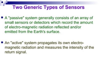
- 1. Two Generic Types of Sensors A "passive" system generally consists of an array of small sensors or detectors which record the amount of electro-magnetic radiation reflected and/or emitted from the Earth's surface. An "active" system propagates its own electro- magnetic radiation and measures the intensity of the return signal.
- 2. Examples of Passive Sensors Advanced Very High Resolution Radiometer (AVHRR)- Sea Surface Temperature Sea-viewing Wide Field-of-View Sensor (SeaWiFS)- Ocean Color
- 3. Why Sea-Surface-Temperature? Sea surface temperature (SST) is a key parameter for energy transfer between the oceans and the atmosphere and AVHRR- derived SST can deliver important data to meteorological and climatological models. AVHRR imagery is also useful for meteorological applications (for example, providing detailed imagery of cloud systems), and land applications such as vegetation mapping and monitoring.
- 4. Advantages of passive microwave remoteAdvantages of passive microwave remote sensingsensing • Sees through clouds at lower frequencies • Long heritage, various instruments since 1978 • Emissivity sensitive to state of surface, particularly moisture – Soil moisture – Snow-water equivalent – (water is ~80× as absorptive as ice at these frequencies, whereas in visible through infrared, water and ice have similar absorption coefficients) • But, because of small amount of energy emitted, pixel size must be large
- 5. ACTIVE SENSORS (Detect the reflected or emitted electromagnetic radiation from natural sources.) PASSIVE SENSORS (Detect reflected responses from objects that are irradiated from artificially-generated energy sources such as radar.) Passive Non-Scanning Non-Imaging. (They are a type of profile recorder, ex. Microwave Radiometer. Magnetic sensor. Gravimeter. Fourier Spectrometer. Imaging. (Example of this are the cameras which can be: Monochrome, Natural Colour, Infrared etc.) Scanning Imaging. Image Plane scanning .Ex. TV Camera Solid scanner. Object Plane scanning. Ex. Optical Mechanical Scanner Microwave radiometer. Active Non-Scanning Non-Imaging. (They are a type of profile recorder, ex. Microwave Radiometer. Microwave Altimeter. Laser Water Depth Meter. Laser Distance Meter. Scanning Imaging. (It is a radar ex. Object Plane scanning: Real Aperture Radar. Synthetic Aperture Radar. Image Plane Scanning: Passive Phased Array Radar.
- 6. IoE 184 - The Basics of Satellite Oceanography. 1. Satellites and Sensors Sensors on satellites Passive sensors Wavelength Information Visible wavelength radiometers 400 nm - 1 µm Solar radiation reflected by Earth surface Infrared (IR) radiometers about 10 µm Thermal emission of the Earth Microwave radiometers 1.5 - 300 mm Thermal emission of the Earth in the microwave Active devices Altimeters 3 - 30 GHz Earth surface topography Scatterometers 3 - 30 GHz Sea surface roughness Synthetic aperture radars 3 - 30 GHz Sea surface roughness and movement
- 7. Microwave Remote Sensing: Principles and Applications. Advantages Day/night coverage. All weather except during periods of heavy rain. Complementary information to that in optical and IR regions. Disadvantages Data are difficult to interpret. Coarse resolution except for SAR.
- 8. Infrared Satellite Imagery These images were obtained with an AVHRR sensor (Advanced Very High Resolution Radiometer) carried on a NOAA Polar Orbiting Environmental Satellite (POES). Measures the amount of thermal infrared radiation given off by the surface of the ocean. The amount of thermal infrared radiation given off by an object is related to its temperature (dying embers give off less radiation than a hot fire and a person gives off even less). Thus by measuring the amount of radiation given off by the ocean we can calculate its temperature.
- 9. Infrared Satellite Imagery These images were obtained with an AVHRR sensor (Advanced Very High Resolution Radiometer) carried on a NOAA Polar Orbiting Environmental Satellite (POES). Measures the amount of thermal infrared radiation given off by the surface of the ocean. The amount of thermal infrared radiation given off by an object is related to its temperature (dying embers give off less radiation than a hot fire and a person gives off even less). Thus by measuring the amount of radiation given off by the ocean we can calculate its temperature.
- 11. Role of space measurements of the earth's topography. This information has wide applications: in geology (e.g., correlating with plate tectonics effects); In geophysics (eg., Distribution of is static imbalances); In climatology (e.g., Orographic barriers), In hydrology (e.g., Drainage basin characteristics); In glaciology (e.g., Ice sheet thicknesses); In ecology (e.g., Ecozone disposition); and In planetology (e.g., Comparative global hypsometry [frequency distribution of elevations]). High resolution regional coverage (on order of 100 m horizontal and 1 m vertical) is technically achievable even now.
- 12. Remote sensing applications Agriculture Mapping crop area Identifying diseases and crop stress Estimating crop yield in conjunction with models Detecting weeds and illicit crops pasture management
- 13. Remote sensing applications Cartography map revision geodesy and photogrammetry merging other data with remote sensing for map presentation use of stereo imagery for topographic mapping compile and update thematic maps of various resources
- 14. Remote sensing applications Engineering routing power lines designing transportation networks site selection
- 15. Remote sensing applications Erosion mapping mapping and monitoring eroded areas predicting potential erosion sites monitoring land degradation and desertification
- 16. Remote sensing applications Geology Identifying lineaments and other structural features mapping geomorphology and geobotany mineral and petroleum exploration analysing landform and drainage identifying rock types identifying oil seepage access planning and base map preparation
- 17. Remote sensing applications Hydrology detecting near-surface aquifers for ground water storage monitoring irrigation performance and usage supplement investigations for flood plain management monitoring on-farm water storage mapping current and potential salinity sites estimating soil moisture and surface temperature planning engineering constructions and monitoring their effectiveness
- 18. Remote sensing applications Meteorology routine atmospheric studies of temperature and weather patterns mapping cloud cover, patterns, composition and temperature weather forecasting flood prediction and monitoring storm warning and damage assessment locating and tracking cyclones monitoring bushfires mapping snow cover, run-off and melt rate detecting chemical and/or particulate composition of the atmosphere climate studies vertical temperature and humidity profiling deducing geopotential height and upper level wind velocity mapping cloud drift winds
- 19. Remote sensing applications Oceanography estimating sea surface temperature ocean colour mapping mapping of sea surface and sea floor topography detecting navigational hazards mapping ocean currents, wind and wave action detecting oil spills, thermal effluent or other pollution mapping fish populations and movements identifying upwelling areas of biological significance studies of sea ice and glacial movement
- 20. Remote sensing applications Renewable resources land cover inventory and monitoring modeling vegetation structure detecting land use changes mapping landform types mapping potential bushfire status assessing the impact of natural disasters such as fire or drought
- 21. Remote sensing applications Shallow water mapping bathymetric studies mapping turbidity and estimating suspended sediment concentration mapping chlorophyll content, such as for algal blooms mapping reef type and morphology monitoring sea grass distribution
- 22. Remote sensing applications Urban studies mapping extent of, and changes, in urban settlements studies of housing density and urban drainage land use planning