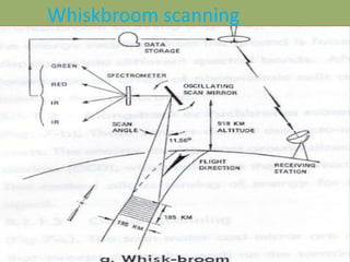
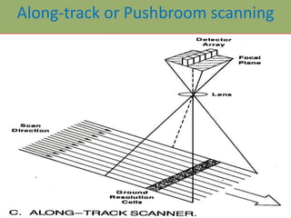
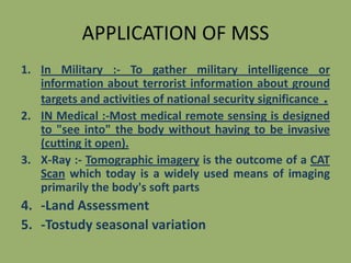
SlideShare a Scribd company logo
1 of 13
Multispectral Remote Sensing

Sumetted by :Dharmendera Kumar meena
Content
1. Interoduction
2. Types Of MS Remote Sensing
(a) Line detector

(b) Wishbroom
(c) Pushbroom
3. Application of MSS
Introduction OF MSS
• Defination :-MSS is define as the collection of
reflected, emitted and backscattered energy from an
object in multiple bands of electromagnetic spectral
OR

•

Multispectral remote sensing is
generally based on acquisition of image data
of Earth's surface simultaneously in multiple
wavelengths.
Types OF MS Remote Sensing
• We Use Mainly Three Types Detector in mss
(a) Line detector
(b) Wishkbroom
(c) Pushbroom
(d)
(a) Line Detector :•
In Line Detector sensor detect
only one object at a time
Whiskbroom scanning
Wiskbroom OR Cross-track
In whiskbroom a mirror of fixed size rotates along an
axis and the energy received from the ground is
focused on to a spectrometer or grating for dispersion
into different spectral bands. After dispersion the
reflected radiation is focused on an array of
photovoltaic cells and energy sensed in different
spectral bands is than calibrated.
The widely used cross-track
scanning system employ a faced mirror that is rotated
by an electric motor, with an horizontal axis of
rotation aligned parallel with the flight direction.
Wiskbroom OR Cross-track
Along-track or Pushbroom scanning
These sensors do not use opto-mechanical device
and have no moving parts. The energy coming from
ground directly falls on the array of charge-coupled
devices {CCD), which calibrate the received energy
and change it to digital counts. This method allows
sensing of energy for larger time and hence results in
better signal.
• GIFOV :- Ground projected instenteneous FOV
• GSI :- Ground projected sample interval
• FOV :- Fieeld of view
• IFOV :- Instenteneous field of view
• GFOV :- Ground projected field of view
Circular scanning
Circular scanning
The scan motor and mirror are mounted with a
vertical axis of rotation that sweeps a circular
path on the terrain. Only forward motion of the
sweep is recorded to produce images. An
advantage of this system is the distance between
scanner and terrain is constant and all the ground
resolution cells have the same dimension.
Circular scanners are used for reconnaissance
purposes in helicopters and low flying aircrafts.
The axis of rotation is tilted to point forward and
acquire images of the terrain well in advance of
the aircraft position.
APPLICATION OF MSS
1. In Military :- To gather military intelligence or
information about terrorist information about ground
targets and activities of national security significance .
2. IN Medical :-Most medical remote sensing is designed
to "see into" the body without having to be invasive
(cutting it open).
3. X-Ray :- Tomographic imagery is the outcome of a CAT
Scan which today is a widely used means of imaging
primarily the body's soft parts

4. -Land Assessment
5. -Tostudy seasonal variation
Multispectral remote sensing

More Related Content

What's hot

Thermal remote sensing
Thermal remote sensing   Thermal remote sensing
Thermal remote sensing Rahat Malik
 
Introduction to Landsat
Introduction to LandsatIntroduction to Landsat
Introduction to LandsatNizam GIS
 
Basics of Remote Sensing
Basics of Remote SensingBasics of Remote Sensing
Basics of Remote SensingAkash Tikhe
 
Remote Sensing Platforms and Its types
Remote Sensing Platforms and Its typesRemote Sensing Platforms and Its types
Remote Sensing Platforms and Its typesSenthamizhan M
 
Microwave remote sensing
Microwave remote sensingMicrowave remote sensing
Microwave remote sensingMohsin Siddique
 
Remote sensing - Sensors, Platforms and Satellite orbits
Remote sensing - Sensors, Platforms and Satellite orbitsRemote sensing - Sensors, Platforms and Satellite orbits
Remote sensing - Sensors, Platforms and Satellite orbitsAjay Singh Lodhi
 
Remote sensing, GPS and GIS ppt
Remote sensing, GPS and GIS pptRemote sensing, GPS and GIS ppt
Remote sensing, GPS and GIS pptNaufil Sayyad
 
Energy interaction with earth surface features
Energy interaction with earth surface featuresEnergy interaction with earth surface features
Energy interaction with earth surface featuressuchismita11
 
SENSORS AND SCANNERS.pptx
SENSORS AND SCANNERS.pptxSENSORS AND SCANNERS.pptx
SENSORS AND SCANNERS.pptxthanga2
 
Remote sensing concept, history and principles
Remote sensing  concept, history and principlesRemote sensing  concept, history and principles
Remote sensing concept, history and principlesAjay Singh Lodhi
 
Indian remote sensing satellites
Indian  remote  sensing  satellitesIndian  remote  sensing  satellites
Indian remote sensing satellitesPramoda Raj
 
Remote sensing-presentaion
Remote sensing-presentaionRemote sensing-presentaion
Remote sensing-presentaionMouna Guru
 
Image interpretation keys & image resolution
Image interpretation keys & image resolutionImage interpretation keys & image resolution
Image interpretation keys & image resolutionPramoda Raj
 
Remote Sensing Platforms and Sensors
Remote Sensing Platforms and SensorsRemote Sensing Platforms and Sensors
Remote Sensing Platforms and SensorsUday kumar Devalla
 

What's hot (20)

Thermal remote sensing
Thermal remote sensing   Thermal remote sensing
Thermal remote sensing
 
Introduction to Landsat
Introduction to LandsatIntroduction to Landsat
Introduction to Landsat
 
Basics of Remote Sensing
Basics of Remote SensingBasics of Remote Sensing
Basics of Remote Sensing
 
Remote Sensing Platforms and Its types
Remote Sensing Platforms and Its typesRemote Sensing Platforms and Its types
Remote Sensing Platforms and Its types
 
Microwave remote sensing
Microwave remote sensingMicrowave remote sensing
Microwave remote sensing
 
Landsat
LandsatLandsat
Landsat
 
Basic of Geodesy
Basic of GeodesyBasic of Geodesy
Basic of Geodesy
 
Remote sensing - Sensors, Platforms and Satellite orbits
Remote sensing - Sensors, Platforms and Satellite orbitsRemote sensing - Sensors, Platforms and Satellite orbits
Remote sensing - Sensors, Platforms and Satellite orbits
 
Microwave remote sensing
Microwave remote sensingMicrowave remote sensing
Microwave remote sensing
 
Remote sensing, GPS and GIS ppt
Remote sensing, GPS and GIS pptRemote sensing, GPS and GIS ppt
Remote sensing, GPS and GIS ppt
 
Introduction to Remote Sensing
Introduction to Remote SensingIntroduction to Remote Sensing
Introduction to Remote Sensing
 
Energy interaction with earth surface features
Energy interaction with earth surface featuresEnergy interaction with earth surface features
Energy interaction with earth surface features
 
SENSORS AND SCANNERS.pptx
SENSORS AND SCANNERS.pptxSENSORS AND SCANNERS.pptx
SENSORS AND SCANNERS.pptx
 
Remote sensing concept, history and principles
Remote sensing  concept, history and principlesRemote sensing  concept, history and principles
Remote sensing concept, history and principles
 
Indian remote sensing satellites
Indian  remote  sensing  satellitesIndian  remote  sensing  satellites
Indian remote sensing satellites
 
Remote sensing-presentaion
Remote sensing-presentaionRemote sensing-presentaion
Remote sensing-presentaion
 
Optical remote sensing
Optical remote sensingOptical remote sensing
Optical remote sensing
 
Remote sensing
Remote sensingRemote sensing
Remote sensing
 
Image interpretation keys & image resolution
Image interpretation keys & image resolutionImage interpretation keys & image resolution
Image interpretation keys & image resolution
 
Remote Sensing Platforms and Sensors
Remote Sensing Platforms and SensorsRemote Sensing Platforms and Sensors
Remote Sensing Platforms and Sensors
 

Similar to Multispectral remote sensing

Continuing chapter rs.pptx
Continuing chapter rs.pptxContinuing chapter rs.pptx
Continuing chapter rs.pptxThomasHundasa1
 
Multi Spectral Scanning Systems
Multi Spectral Scanning SystemsMulti Spectral Scanning Systems
Multi Spectral Scanning SystemsSenthamizhan M
 
Unit 1 introduction to remote sensing
Unit  1 introduction to remote sensing Unit  1 introduction to remote sensing
Unit 1 introduction to remote sensing Dhanalakshmi Dasari
 
Remote Sensing: Meaning, Concept and Components | Geography
Remote Sensing: Meaning, Concept and Components | GeographyRemote Sensing: Meaning, Concept and Components | Geography
Remote Sensing: Meaning, Concept and Components | GeographySrimantaKarak
 
Remote Sensing Data Acquisition,Scanning/Imaging systems
Remote Sensing Data Acquisition,Scanning/Imaging systemsRemote Sensing Data Acquisition,Scanning/Imaging systems
Remote Sensing Data Acquisition,Scanning/Imaging systemsdaniyal rustam
 
Chapter 1 (Introduction to remote sensing)
Chapter 1 (Introduction to remote sensing)Chapter 1 (Introduction to remote sensing)
Chapter 1 (Introduction to remote sensing)Shankar Gangaju
 
Resolution and scanning system
Resolution and scanning systemResolution and scanning system
Resolution and scanning systemAglaia Connect
 
Remote sensing: Its Application & Types
Remote sensing: Its Application & TypesRemote sensing: Its Application & Types
Remote sensing: Its Application & Typesasdfg484362
 
A Brief Introduction to Remote Sensing Satellites
A Brief Introduction to Remote Sensing Satellites A Brief Introduction to Remote Sensing Satellites
A Brief Introduction to Remote Sensing Satellites Alireza Rahimzadeganasl
 
CE203 -Photogrammetry & GPS.ppt
CE203 -Photogrammetry & GPS.pptCE203 -Photogrammetry & GPS.ppt
CE203 -Photogrammetry & GPS.pptAbdulQHannan
 
Surveying ii ajith sir class4
Surveying ii ajith sir class4Surveying ii ajith sir class4
Surveying ii ajith sir class4SHAMJITH KM
 
Scanners, image resolution, orbit in remote sensing, pk mani
Scanners, image resolution, orbit in remote sensing, pk maniScanners, image resolution, orbit in remote sensing, pk mani
Scanners, image resolution, orbit in remote sensing, pk maniP.K. Mani
 

Similar to Multispectral remote sensing (20)

Continuing chapter rs.pptx
Continuing chapter rs.pptxContinuing chapter rs.pptx
Continuing chapter rs.pptx
 
Multi Spectral Scanning Systems
Multi Spectral Scanning SystemsMulti Spectral Scanning Systems
Multi Spectral Scanning Systems
 
Kannan RS.ppt
Kannan RS.pptKannan RS.ppt
Kannan RS.ppt
 
Remote sensing
Remote sensingRemote sensing
Remote sensing
 
Remote Sensin
Remote SensinRemote Sensin
Remote Sensin
 
Unit 1 introduction to remote sensing
Unit  1 introduction to remote sensing Unit  1 introduction to remote sensing
Unit 1 introduction to remote sensing
 
RS_GIS_GPS.pdf
RS_GIS_GPS.pdfRS_GIS_GPS.pdf
RS_GIS_GPS.pdf
 
Remote Sensing: Meaning, Concept and Components | Geography
Remote Sensing: Meaning, Concept and Components | GeographyRemote Sensing: Meaning, Concept and Components | Geography
Remote Sensing: Meaning, Concept and Components | Geography
 
Remote Sensing Data Acquisition,Scanning/Imaging systems
Remote Sensing Data Acquisition,Scanning/Imaging systemsRemote Sensing Data Acquisition,Scanning/Imaging systems
Remote Sensing Data Acquisition,Scanning/Imaging systems
 
Remote sensing
Remote sensingRemote sensing
Remote sensing
 
Chapter 1 (Introduction to remote sensing)
Chapter 1 (Introduction to remote sensing)Chapter 1 (Introduction to remote sensing)
Chapter 1 (Introduction to remote sensing)
 
Resolution and scanning system
Resolution and scanning systemResolution and scanning system
Resolution and scanning system
 
Remote sensing
Remote sensingRemote sensing
Remote sensing
 
Remote sensing: Its Application & Types
Remote sensing: Its Application & TypesRemote sensing: Its Application & Types
Remote sensing: Its Application & Types
 
REMOTE SENSING
REMOTE SENSINGREMOTE SENSING
REMOTE SENSING
 
A Brief Introduction to Remote Sensing Satellites
A Brief Introduction to Remote Sensing Satellites A Brief Introduction to Remote Sensing Satellites
A Brief Introduction to Remote Sensing Satellites
 
remote sensing
remote sensingremote sensing
remote sensing
 
CE203 -Photogrammetry & GPS.ppt
CE203 -Photogrammetry & GPS.pptCE203 -Photogrammetry & GPS.ppt
CE203 -Photogrammetry & GPS.ppt
 
Surveying ii ajith sir class4
Surveying ii ajith sir class4Surveying ii ajith sir class4
Surveying ii ajith sir class4
 
Scanners, image resolution, orbit in remote sensing, pk mani
Scanners, image resolution, orbit in remote sensing, pk maniScanners, image resolution, orbit in remote sensing, pk mani
Scanners, image resolution, orbit in remote sensing, pk mani
 

Recently uploaded

call girls in Kamla Market (DELHI) 🔝 >༒9953330565🔝 genuine Escort Service 🔝✔️✔️
call girls in Kamla Market (DELHI) 🔝 >༒9953330565🔝 genuine Escort Service 🔝✔️✔️call girls in Kamla Market (DELHI) 🔝 >༒9953330565🔝 genuine Escort Service 🔝✔️✔️
call girls in Kamla Market (DELHI) 🔝 >༒9953330565🔝 genuine Escort Service 🔝✔️✔️9953056974 Low Rate Call Girls In Saket, Delhi NCR
 
Proudly South Africa powerpoint Thorisha.pptx
Proudly South Africa powerpoint Thorisha.pptxProudly South Africa powerpoint Thorisha.pptx
Proudly South Africa powerpoint Thorisha.pptxthorishapillay1
 
Barangay Council for the Protection of Children (BCPC) Orientation.pptx
Barangay Council for the Protection of Children (BCPC) Orientation.pptxBarangay Council for the Protection of Children (BCPC) Orientation.pptx
Barangay Council for the Protection of Children (BCPC) Orientation.pptxCarlos105
 
HỌC TỐT TIẾNG ANH 11 THEO CHƯƠNG TRÌNH GLOBAL SUCCESS ĐÁP ÁN CHI TIẾT - CẢ NĂ...
HỌC TỐT TIẾNG ANH 11 THEO CHƯƠNG TRÌNH GLOBAL SUCCESS ĐÁP ÁN CHI TIẾT - CẢ NĂ...HỌC TỐT TIẾNG ANH 11 THEO CHƯƠNG TRÌNH GLOBAL SUCCESS ĐÁP ÁN CHI TIẾT - CẢ NĂ...
HỌC TỐT TIẾNG ANH 11 THEO CHƯƠNG TRÌNH GLOBAL SUCCESS ĐÁP ÁN CHI TIẾT - CẢ NĂ...Nguyen Thanh Tu Collection
 
Full Stack Web Development Course for Beginners
Full Stack Web Development Course  for BeginnersFull Stack Web Development Course  for Beginners
Full Stack Web Development Course for BeginnersSabitha Banu
 
INTRODUCTION TO CATHOLIC CHRISTOLOGY.pptx
INTRODUCTION TO CATHOLIC CHRISTOLOGY.pptxINTRODUCTION TO CATHOLIC CHRISTOLOGY.pptx
INTRODUCTION TO CATHOLIC CHRISTOLOGY.pptxHumphrey A Beña
 
4.18.24 Movement Legacies, Reflection, and Review.pptx
4.18.24 Movement Legacies, Reflection, and Review.pptx4.18.24 Movement Legacies, Reflection, and Review.pptx
4.18.24 Movement Legacies, Reflection, and Review.pptxmary850239
 
Influencing policy (training slides from Fast Track Impact)
Influencing policy (training slides from Fast Track Impact)Influencing policy (training slides from Fast Track Impact)
Influencing policy (training slides from Fast Track Impact)Mark Reed
 
THEORIES OF ORGANIZATION-PUBLIC ADMINISTRATION
THEORIES OF ORGANIZATION-PUBLIC ADMINISTRATIONTHEORIES OF ORGANIZATION-PUBLIC ADMINISTRATION
THEORIES OF ORGANIZATION-PUBLIC ADMINISTRATIONHumphrey A Beña
 
Field Attribute Index Feature in Odoo 17
Field Attribute Index Feature in Odoo 17Field Attribute Index Feature in Odoo 17
Field Attribute Index Feature in Odoo 17Celine George
 
Choosing the Right CBSE School A Comprehensive Guide for Parents
Choosing the Right CBSE School A Comprehensive Guide for ParentsChoosing the Right CBSE School A Comprehensive Guide for Parents
Choosing the Right CBSE School A Comprehensive Guide for Parentsnavabharathschool99
 
ECONOMIC CONTEXT - PAPER 1 Q3: NEWSPAPERS.pptx
ECONOMIC CONTEXT - PAPER 1 Q3: NEWSPAPERS.pptxECONOMIC CONTEXT - PAPER 1 Q3: NEWSPAPERS.pptx
ECONOMIC CONTEXT - PAPER 1 Q3: NEWSPAPERS.pptxiammrhaywood
 
GRADE 4 - SUMMATIVE TEST QUARTER 4 ALL SUBJECTS
GRADE 4 - SUMMATIVE TEST QUARTER 4 ALL SUBJECTSGRADE 4 - SUMMATIVE TEST QUARTER 4 ALL SUBJECTS
GRADE 4 - SUMMATIVE TEST QUARTER 4 ALL SUBJECTSJoshuaGantuangco2
 
Science 7 Quarter 4 Module 2: Natural Resources.pptx
Science 7 Quarter 4 Module 2: Natural Resources.pptxScience 7 Quarter 4 Module 2: Natural Resources.pptx
Science 7 Quarter 4 Module 2: Natural Resources.pptxMaryGraceBautista27
 
DATA STRUCTURE AND ALGORITHM for beginners
DATA STRUCTURE AND ALGORITHM for beginnersDATA STRUCTURE AND ALGORITHM for beginners
DATA STRUCTURE AND ALGORITHM for beginnersSabitha Banu
 

Recently uploaded (20)

call girls in Kamla Market (DELHI) 🔝 >༒9953330565🔝 genuine Escort Service 🔝✔️✔️
call girls in Kamla Market (DELHI) 🔝 >༒9953330565🔝 genuine Escort Service 🔝✔️✔️call girls in Kamla Market (DELHI) 🔝 >༒9953330565🔝 genuine Escort Service 🔝✔️✔️
call girls in Kamla Market (DELHI) 🔝 >༒9953330565🔝 genuine Escort Service 🔝✔️✔️
 
Proudly South Africa powerpoint Thorisha.pptx
Proudly South Africa powerpoint Thorisha.pptxProudly South Africa powerpoint Thorisha.pptx
Proudly South Africa powerpoint Thorisha.pptx
 
Barangay Council for the Protection of Children (BCPC) Orientation.pptx
Barangay Council for the Protection of Children (BCPC) Orientation.pptxBarangay Council for the Protection of Children (BCPC) Orientation.pptx
Barangay Council for the Protection of Children (BCPC) Orientation.pptx
 
HỌC TỐT TIẾNG ANH 11 THEO CHƯƠNG TRÌNH GLOBAL SUCCESS ĐÁP ÁN CHI TIẾT - CẢ NĂ...
HỌC TỐT TIẾNG ANH 11 THEO CHƯƠNG TRÌNH GLOBAL SUCCESS ĐÁP ÁN CHI TIẾT - CẢ NĂ...HỌC TỐT TIẾNG ANH 11 THEO CHƯƠNG TRÌNH GLOBAL SUCCESS ĐÁP ÁN CHI TIẾT - CẢ NĂ...
HỌC TỐT TIẾNG ANH 11 THEO CHƯƠNG TRÌNH GLOBAL SUCCESS ĐÁP ÁN CHI TIẾT - CẢ NĂ...
 
Full Stack Web Development Course for Beginners
Full Stack Web Development Course  for BeginnersFull Stack Web Development Course  for Beginners
Full Stack Web Development Course for Beginners
 
INTRODUCTION TO CATHOLIC CHRISTOLOGY.pptx
INTRODUCTION TO CATHOLIC CHRISTOLOGY.pptxINTRODUCTION TO CATHOLIC CHRISTOLOGY.pptx
INTRODUCTION TO CATHOLIC CHRISTOLOGY.pptx
 
4.18.24 Movement Legacies, Reflection, and Review.pptx
4.18.24 Movement Legacies, Reflection, and Review.pptx4.18.24 Movement Legacies, Reflection, and Review.pptx
4.18.24 Movement Legacies, Reflection, and Review.pptx
 
YOUVE_GOT_EMAIL_PRELIMS_EL_DORADO_2024.pptx
YOUVE_GOT_EMAIL_PRELIMS_EL_DORADO_2024.pptxYOUVE_GOT_EMAIL_PRELIMS_EL_DORADO_2024.pptx
YOUVE_GOT_EMAIL_PRELIMS_EL_DORADO_2024.pptx
 
Influencing policy (training slides from Fast Track Impact)
Influencing policy (training slides from Fast Track Impact)Influencing policy (training slides from Fast Track Impact)
Influencing policy (training slides from Fast Track Impact)
 
THEORIES OF ORGANIZATION-PUBLIC ADMINISTRATION
THEORIES OF ORGANIZATION-PUBLIC ADMINISTRATIONTHEORIES OF ORGANIZATION-PUBLIC ADMINISTRATION
THEORIES OF ORGANIZATION-PUBLIC ADMINISTRATION
 
OS-operating systems- ch04 (Threads) ...
OS-operating systems- ch04 (Threads) ...OS-operating systems- ch04 (Threads) ...
OS-operating systems- ch04 (Threads) ...
 
Raw materials used in Herbal Cosmetics.pptx
Raw materials used in Herbal Cosmetics.pptxRaw materials used in Herbal Cosmetics.pptx
Raw materials used in Herbal Cosmetics.pptx
 
Field Attribute Index Feature in Odoo 17
Field Attribute Index Feature in Odoo 17Field Attribute Index Feature in Odoo 17
Field Attribute Index Feature in Odoo 17
 
Choosing the Right CBSE School A Comprehensive Guide for Parents
Choosing the Right CBSE School A Comprehensive Guide for ParentsChoosing the Right CBSE School A Comprehensive Guide for Parents
Choosing the Right CBSE School A Comprehensive Guide for Parents
 
ECONOMIC CONTEXT - PAPER 1 Q3: NEWSPAPERS.pptx
ECONOMIC CONTEXT - PAPER 1 Q3: NEWSPAPERS.pptxECONOMIC CONTEXT - PAPER 1 Q3: NEWSPAPERS.pptx
ECONOMIC CONTEXT - PAPER 1 Q3: NEWSPAPERS.pptx
 
GRADE 4 - SUMMATIVE TEST QUARTER 4 ALL SUBJECTS
GRADE 4 - SUMMATIVE TEST QUARTER 4 ALL SUBJECTSGRADE 4 - SUMMATIVE TEST QUARTER 4 ALL SUBJECTS
GRADE 4 - SUMMATIVE TEST QUARTER 4 ALL SUBJECTS
 
FINALS_OF_LEFT_ON_C'N_EL_DORADO_2024.pptx
FINALS_OF_LEFT_ON_C'N_EL_DORADO_2024.pptxFINALS_OF_LEFT_ON_C'N_EL_DORADO_2024.pptx
FINALS_OF_LEFT_ON_C'N_EL_DORADO_2024.pptx
 
Science 7 Quarter 4 Module 2: Natural Resources.pptx
Science 7 Quarter 4 Module 2: Natural Resources.pptxScience 7 Quarter 4 Module 2: Natural Resources.pptx
Science 7 Quarter 4 Module 2: Natural Resources.pptx
 
LEFT_ON_C'N_ PRELIMS_EL_DORADO_2024.pptx
LEFT_ON_C'N_ PRELIMS_EL_DORADO_2024.pptxLEFT_ON_C'N_ PRELIMS_EL_DORADO_2024.pptx
LEFT_ON_C'N_ PRELIMS_EL_DORADO_2024.pptx
 
DATA STRUCTURE AND ALGORITHM for beginners
DATA STRUCTURE AND ALGORITHM for beginnersDATA STRUCTURE AND ALGORITHM for beginners
DATA STRUCTURE AND ALGORITHM for beginners
 

Multispectral remote sensing

  • 1. Multispectral Remote Sensing Sumetted by :Dharmendera Kumar meena
  • 2. Content 1. Interoduction 2. Types Of MS Remote Sensing (a) Line detector (b) Wishbroom (c) Pushbroom 3. Application of MSS
  • 3. Introduction OF MSS • Defination :-MSS is define as the collection of reflected, emitted and backscattered energy from an object in multiple bands of electromagnetic spectral OR • Multispectral remote sensing is generally based on acquisition of image data of Earth's surface simultaneously in multiple wavelengths.
  • 4. Types OF MS Remote Sensing • We Use Mainly Three Types Detector in mss (a) Line detector (b) Wishkbroom (c) Pushbroom (d) (a) Line Detector :• In Line Detector sensor detect only one object at a time
  • 6. Wiskbroom OR Cross-track In whiskbroom a mirror of fixed size rotates along an axis and the energy received from the ground is focused on to a spectrometer or grating for dispersion into different spectral bands. After dispersion the reflected radiation is focused on an array of photovoltaic cells and energy sensed in different spectral bands is than calibrated. The widely used cross-track scanning system employ a faced mirror that is rotated by an electric motor, with an horizontal axis of rotation aligned parallel with the flight direction.
  • 9. Along-track or Pushbroom scanning These sensors do not use opto-mechanical device and have no moving parts. The energy coming from ground directly falls on the array of charge-coupled devices {CCD), which calibrate the received energy and change it to digital counts. This method allows sensing of energy for larger time and hence results in better signal. • GIFOV :- Ground projected instenteneous FOV • GSI :- Ground projected sample interval • FOV :- Fieeld of view • IFOV :- Instenteneous field of view • GFOV :- Ground projected field of view
  • 11. Circular scanning The scan motor and mirror are mounted with a vertical axis of rotation that sweeps a circular path on the terrain. Only forward motion of the sweep is recorded to produce images. An advantage of this system is the distance between scanner and terrain is constant and all the ground resolution cells have the same dimension. Circular scanners are used for reconnaissance purposes in helicopters and low flying aircrafts. The axis of rotation is tilted to point forward and acquire images of the terrain well in advance of the aircraft position.
  • 12. APPLICATION OF MSS 1. In Military :- To gather military intelligence or information about terrorist information about ground targets and activities of national security significance . 2. IN Medical :-Most medical remote sensing is designed to "see into" the body without having to be invasive (cutting it open). 3. X-Ray :- Tomographic imagery is the outcome of a CAT Scan which today is a widely used means of imaging primarily the body's soft parts 4. -Land Assessment 5. -Tostudy seasonal variation