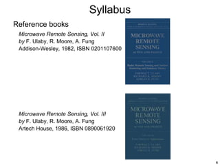
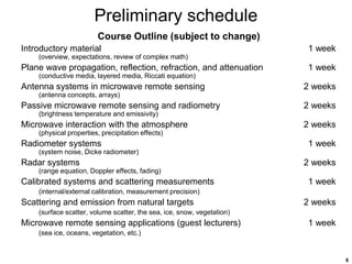
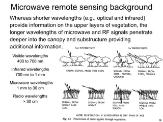
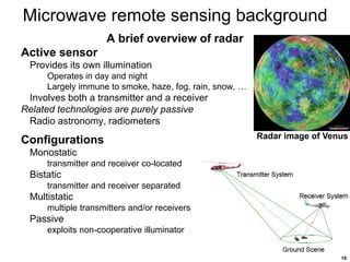
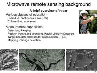
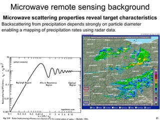
SlideShare a Scribd company logo
1
Microwave Remote Sensing
Chris Allen (callen@eecs.ku.edu)
Course website URL
people.eecs.ku.edu/~callen/823/EECS823.htm
2
Outline
Syllabus
Instructor information, course description, prerequisites
Textbook, reference books, grading, course outline
Preliminary schedule
Introductions
What to expect
First assignment
Microwave remote sensing background
Microwave remote sensing compared to optical remote sensing
Overview of radar
Microwave scattering properties
Radiometry principles and example
3
Syllabus
Prof. Chris Allen
Ph.D. in Electrical Engineering from KU 1984
10 years industry experience
Sandia National Labs, Albuquerque, NM
AlliedSignal, Kansas City Plant, Kansas City, MO
Phone: 785-864-8801
Email: callen@eecs.ku.edu
Office: 3024 Eaton Hall
Office hours: Tuesdays and Thursdays
10:00 to 10:45 am
Course description
Description and analysis of basic microwave remote sensing systems
including radars and radiometers as well as the scattering and emission
properties of natural targets. Topics covered include plane wave
propagation, antennas, radiometers, atmospheric effects, radars,
calibrated systems, and remote sensing applications.
4
Syllabus
Prerequisites
Introductory course on electromagnetics (e.g., EECS 420 or 720)
Introductory course on RF transmission systems (e.g., EECS 622)
Textbook
Microwave Radar and Radiometric Remote Sensing
by F.T. Ulaby, D.G. Long
University of Michigan Press, 2013,
ISBN 0472119354
1116 pages
This is a new textbook that contains
what was previously available
in the Volume I of the
Microwave Remote Sensing series.
5
Syllabus
Reference books
Microwave Remote Sensing: Active and
Passive, Volume I: Microwave remote
sensing fundamentals and radiometry
by F. Ulaby, R. Moore, A. Fung
Addison-Wesley, 1981, ISBN 0201107597
Unfortunately this textbook is out of print and is only available
in the used book market.
Unfortunately this textbook is out of print
and is only available in the used book
market.
Nice-quality, affordable copies were available through the
KU bookstore but no longer.
6
Syllabus
Reference books
Microwave Remote Sensing, Vol. II
by F. Ulaby, R. Moore, A. Fung
Addison-Wesley, 1982, ISBN 0201107600
Microwave Remote Sensing, Vol. III
by F. Ulaby, R. Moore, A. Fung
Artech House, 1986, ISBN 0890061920
7
Grades and course policies
The following factors will be used to arrive at the final
course grade:
Homework, quizzes, and class participation 40 %
Research project 20 %
Final exam 40 %
Grades will be assigned to the following scale:
A 90 - 100 %
B 80 - 89 %
C 70 - 79 %
D 60 - 69 %
F < 60 %
These are guaranteed maximum scales and may be revised downward at the
instructor's discretion.
Read the policies regarding homework, exams, ethics, and
plagiarism.
8
Preliminary schedule
Course Outline (subject to change)
Introductory material 1 week
(overview, expectations, review of complex math)
Plane wave propagation, reflection, refraction, and attenuation 1 week
(conductive media, layered media, Riccati equation)
Antenna systems in microwave remote sensing 2 weeks
(antenna concepts, arrays)
Passive microwave remote sensing and radiometry 2 weeks
(brightness temperature and emissivity)
Microwave interaction with the atmosphere 2 weeks
(physical properties, precipitation effects)
Radiometer systems 1 week
(system noise, Dicke radiometer)
Radar systems 2 weeks
(range equation, Doppler effects, fading)
Calibrated systems and scattering measurements 1 week
(internal/external calibration, measurement precision)
Scattering and emission from natural targets 2 weeks
(surface scatter, volume scatter, the sea, ice, snow, vegetation)
Microwave remote sensing applications (guest lecturers) 1 week
(sea ice, oceans, vegetation, etc.)
9
Preliminary schedule
Fall 2020 Class Meeting Schedule
August: 25, 27
September: 1, 3, 8, 10, 15, 17, 22, 24, 29
October: 1, 6, 8, 13, 15, 20, 22, 27, 29
November: 3, 5, 10, 12, 17, 24
Final exam scheduled for
Wednesday, December 9
10:30 to 1:00 p.m.
10
Introductions
Name
Major
Specialty
What you hope to get from of this experience
(Not asking what grade you are aiming for )
11
What to expect
Course is being webcast, therefore …
Most presentation material will be in PowerPoint format 
Presentations will be recorded and archived (for duration of semester)
Student interaction is encouraged
Remote students must activate microphone before speaking
Please disable microphone when finished
Homework assignments will be posted on website
Electronic homework submission logistics to be worked out
We may have guest lecturers later in the semester
To break the monotony, we’ll try to take a couple of
2-minute breaks during each session (roughly every 15 to 20 min)
12
Course coverage areas
13
Course coverage areas
Course will focus on
• electromagnetic propagation & scattering
• antennas
• atmospheric effects
• radiometry and radiometers
14
Your first assignment
Send me an email (from the account you check most often)
To: callen@eecs.ku.edu
Subject line: Your name – 823
Tell me a little about yourself
Attach your ARTS form (or equivalent)
ARTS: Academic Requirements Tracking System
Its basically an unofficial academic record
I use this to get a sense of what academic experiences you’ve had
15
Microwave remote sensing background
Optical remote sensing has been around a long time
• Uses the visible part of the electromagnetic spectrum
• Instrumentation includes the human eye, cameras, telescopes
• Has problems with clouds, rain, fog, snow, smoke, smog, etc.
• Cannot penetrate soil, vegetation, snowpack, ice
• Relies on ambient light sources (e.g., sunlight)
Microwave remote sensing is less than 100 years old
• Uses the microwave and RF parts of the spectrum
• Instrumentation includes radars and radiometers
• Is largely immune to clouds, precipitation, smoke, etc.
• Penetrates sand, soil, rock, vegetation, dry snow, ice, etc.
• Does not rely on sunlight – radar provides its own illumination,
radiometers use the target’s thermal emission
Data from microwave sensors complement data from
optical sensors
16
Microwave remote sensing background
Whereas shorter wavelengths (e.g., optical and infrared)
provide information on the upper layers of vegetation, the
longer wavelengths of microwave and RF signals penetrate
deeper into the canopy and substructure providing
additional information.
Visible wavelengths
400 to 700 nm
Infrared wavelengths
700 nm to 1 mm
Microwave wavelengths
1 mm to 30 cm
Radio wavelengths
> 30 cm
17
Microwave remote sensing background
A brief overview of radar
Radar – radio detection and ranging
Developed in the early 1900s (pre-World War II)
• 1904 Europeans demonstrated use for detecting ships in fog
• 1922 U.S. Navy Research Laboratory (NRL) detected wooden ship on Potomac
River
• 1930 NRL engineers detected an aircraft with simple radar system
World War II accelerated radar’s development
• Radar had a significant impact militarily
• Called “The Invention That Changed The World” in two books by Robert
Buderi
Radar’s has deep military roots
• It continues to be important militarily
• Growing number of civil applications
• Objects often called ‘targets’ even civil applications
18
Microwave remote sensing background
A brief overview of radar
Uses electromagnetic (EM) waves
Frequencies in the MHz, GHz, THz
Shares spectrum with FM, TV, GPS, cell phones, wireless technologies,
satellite communications
Governed by Maxwell’s equations
Signals propagate at the speed of light
Antennas or optics used to launch/receive waves
Related technologies use acoustic waves
Ultrasound, seismics, sonar
Microphones, accelerometers, hydrophones used as transducers
19
Microwave remote sensing background
A brief overview of radar
Active sensor
Provides its own illumination
Operates in day and night
Largely immune to smoke, haze, fog, rain, snow, …
Involves both a transmitter and a receiver
Related technologies are purely passive
Radio astronomy, radiometers
Configurations
Monostatic
transmitter and receiver co-located
Bistatic
transmitter and receiver separated
Multistatic
multiple transmitters and/or receivers
Passive
exploits non-cooperative illuminator
Radar image of Venus
20
Microwave remote sensing background
A brief overview of radar
Various classes of operation
Pulsed vs. continuous wave (CW)
Coherent vs. incoherent
Measurement capabilities
Detection, Ranging
Position (range and direction), Radial velocity (Doppler)
Target characteristics (radar cross section – RCS)
Mapping, Change detection
21
Microwave remote sensing background
Microwave scattering properties reveal target characteristics
Backscattering from precipitation depends strongly on particle diameter
enabling a mapping of precipitation rates using radar data.
22
Microwave remote sensing background
Radiometry principles
Materials above 0 K emit
electromagnetic radiation that
follows a well-defined pattern. This
radiation can be measured at a
variety of frequencies and
polarizations. Analysis of the
measured emission characteristics
reveal properties about the scene.
23
Microwave remote sensing background
Advanced Microwave Scanning Radiometer -
Earth Observing System (AMSR-E) instrument was
launched aboard NASA's Earth Observing System
(EOS) Aqua Satellite on 4 May 2002. The AMSR-E
is a twelve-channel, six-frequency, conically-
scanning, passive-microwave radiometer system. It
measures horizontally and vertically polarized
microwave radiation (brightness temperatures)
ranging from 6.9 GHz to 89.0 GHz. Spatial
resolution of the individual measurements varies
from 5.4 km at 89 GHz to 56 km at 6.9 GHz.

More Related Content

Similar to 823_Intro-F20.ppt

CSP microproject (join all india polytechnic AICTE telegram group (SONAR sys...
CSP microproject  (join all india polytechnic AICTE telegram group (SONAR sys...CSP microproject  (join all india polytechnic AICTE telegram group (SONAR sys...
CSP microproject (join all india polytechnic AICTE telegram group (SONAR sys...
VivekSharma34623
 
Spectrophotometry methods for molecule analysis
Spectrophotometry methods for molecule analysisSpectrophotometry methods for molecule analysis
Spectrophotometry methods for molecule analysis
ygpark2221
 
rsgis-unitii-160731062950.pdf
rsgis-unitii-160731062950.pdfrsgis-unitii-160731062950.pdf
rsgis-unitii-160731062950.pdf
BSuresh26
 
Introduction to Remote Sensing
Introduction to Remote SensingIntroduction to Remote Sensing
Introduction to Remote Sensing
Malla Reddy University
 
Environmental Remote Sensing
 Environmental Remote Sensing  Environmental Remote Sensing
Environmental Remote Sensing
Ghassan Hadi
 
Fundamentals of remote sensing
Fundamentals of remote sensingFundamentals of remote sensing
Fundamentals of remote sensing
Ghassan Hadi
 
Remote Sensing
Remote SensingRemote Sensing
Remote Sensing
Lax Koirala
 
Fundamentals of remonte sensing
Fundamentals of remonte sensingFundamentals of remonte sensing
Fundamentals of remonte sensing
Si Mokrane SIAD
 
Propagationeffectsforradarcommcoursesamplernowatermark 090305142801-phpapp01
Propagationeffectsforradarcommcoursesamplernowatermark 090305142801-phpapp01Propagationeffectsforradarcommcoursesamplernowatermark 090305142801-phpapp01
Propagationeffectsforradarcommcoursesamplernowatermark 090305142801-phpapp01RRFF
 
Rahul seminar2 2_for_slideshare.pptx
Rahul seminar2 2_for_slideshare.pptxRahul seminar2 2_for_slideshare.pptx
Rahul seminar2 2_for_slideshare.pptx
RahulSingh769902
 
R18 b.tech 3 2 ece syllabus
R18 b.tech 3 2 ece syllabusR18 b.tech 3 2 ece syllabus
R18 b.tech 3 2 ece syllabus
Venkata Rajitha M
 
Remote sensing & Radiometers Systems
Remote sensing & Radiometers Systems Remote sensing & Radiometers Systems
Remote sensing & Radiometers Systems
Jay Baria
 
Spectroscopy
SpectroscopySpectroscopy
Spectroscopy
Arpit Modh
 
ROHINI RADAR
ROHINI RADARROHINI RADAR
ROHINI RADAR
shiv kapil
 
Remote sensing
Remote sensingRemote sensing
Remote sensingGokul Saud
 
APPLICATION OF REMOTE SENSING AND GIS IN AGRICULTURE
APPLICATION OF REMOTE SENSING AND GIS IN AGRICULTUREAPPLICATION OF REMOTE SENSING AND GIS IN AGRICULTURE
APPLICATION OF REMOTE SENSING AND GIS IN AGRICULTURE
LagnajeetRoy
 
ROHINI RADAR PFD
ROHINI RADAR PFDROHINI RADAR PFD
ROHINI RADAR PFD
shiv kapil
 
Introduction to Remote Sensing- Remote sensing” is the science (and to some e...
Introduction to Remote Sensing- Remote sensing” is the science (and to some e...Introduction to Remote Sensing- Remote sensing” is the science (and to some e...
Introduction to Remote Sensing- Remote sensing” is the science (and to some e...
Ange Felix NSANZIYERA
 
N 1-awp-lecture-notes-final
N 1-awp-lecture-notes-finalN 1-awp-lecture-notes-final
N 1-awp-lecture-notes-final
15010192
 
Awp lecture notes
Awp lecture notesAwp lecture notes
Awp lecture notes
dck2010
 

Similar to 823_Intro-F20.ppt (20)

CSP microproject (join all india polytechnic AICTE telegram group (SONAR sys...
CSP microproject  (join all india polytechnic AICTE telegram group (SONAR sys...CSP microproject  (join all india polytechnic AICTE telegram group (SONAR sys...
CSP microproject (join all india polytechnic AICTE telegram group (SONAR sys...
 
Spectrophotometry methods for molecule analysis
Spectrophotometry methods for molecule analysisSpectrophotometry methods for molecule analysis
Spectrophotometry methods for molecule analysis
 
rsgis-unitii-160731062950.pdf
rsgis-unitii-160731062950.pdfrsgis-unitii-160731062950.pdf
rsgis-unitii-160731062950.pdf
 
Introduction to Remote Sensing
Introduction to Remote SensingIntroduction to Remote Sensing
Introduction to Remote Sensing
 
Environmental Remote Sensing
 Environmental Remote Sensing  Environmental Remote Sensing
Environmental Remote Sensing
 
Fundamentals of remote sensing
Fundamentals of remote sensingFundamentals of remote sensing
Fundamentals of remote sensing
 
Remote Sensing
Remote SensingRemote Sensing
Remote Sensing
 
Fundamentals of remonte sensing
Fundamentals of remonte sensingFundamentals of remonte sensing
Fundamentals of remonte sensing
 
Propagationeffectsforradarcommcoursesamplernowatermark 090305142801-phpapp01
Propagationeffectsforradarcommcoursesamplernowatermark 090305142801-phpapp01Propagationeffectsforradarcommcoursesamplernowatermark 090305142801-phpapp01
Propagationeffectsforradarcommcoursesamplernowatermark 090305142801-phpapp01
 
Rahul seminar2 2_for_slideshare.pptx
Rahul seminar2 2_for_slideshare.pptxRahul seminar2 2_for_slideshare.pptx
Rahul seminar2 2_for_slideshare.pptx
 
R18 b.tech 3 2 ece syllabus
R18 b.tech 3 2 ece syllabusR18 b.tech 3 2 ece syllabus
R18 b.tech 3 2 ece syllabus
 
Remote sensing & Radiometers Systems
Remote sensing & Radiometers Systems Remote sensing & Radiometers Systems
Remote sensing & Radiometers Systems
 
Spectroscopy
SpectroscopySpectroscopy
Spectroscopy
 
ROHINI RADAR
ROHINI RADARROHINI RADAR
ROHINI RADAR
 
Remote sensing
Remote sensingRemote sensing
Remote sensing
 
APPLICATION OF REMOTE SENSING AND GIS IN AGRICULTURE
APPLICATION OF REMOTE SENSING AND GIS IN AGRICULTUREAPPLICATION OF REMOTE SENSING AND GIS IN AGRICULTURE
APPLICATION OF REMOTE SENSING AND GIS IN AGRICULTURE
 
ROHINI RADAR PFD
ROHINI RADAR PFDROHINI RADAR PFD
ROHINI RADAR PFD
 
Introduction to Remote Sensing- Remote sensing” is the science (and to some e...
Introduction to Remote Sensing- Remote sensing” is the science (and to some e...Introduction to Remote Sensing- Remote sensing” is the science (and to some e...
Introduction to Remote Sensing- Remote sensing” is the science (and to some e...
 
N 1-awp-lecture-notes-final
N 1-awp-lecture-notes-finalN 1-awp-lecture-notes-final
N 1-awp-lecture-notes-final
 
Awp lecture notes
Awp lecture notesAwp lecture notes
Awp lecture notes
 

More from Manasutthasini2

557_Apollo16.pptx
557_Apollo16.pptx557_Apollo16.pptx
557_Apollo16.pptx
Manasutthasini2
 
2016.09.19_15.30_Agency_Reports_ISRO.pptx
2016.09.19_15.30_Agency_Reports_ISRO.pptx2016.09.19_15.30_Agency_Reports_ISRO.pptx
2016.09.19_15.30_Agency_Reports_ISRO.pptx
Manasutthasini2
 
17_Bock_HyperspectralRS_v1.pptx
17_Bock_HyperspectralRS_v1.pptx17_Bock_HyperspectralRS_v1.pptx
17_Bock_HyperspectralRS_v1.pptx
Manasutthasini2
 
Pedelty_Lassen06.ppt
Pedelty_Lassen06.pptPedelty_Lassen06.ppt
Pedelty_Lassen06.ppt
Manasutthasini2
 
HYPERSPECTRAL.ppt
HYPERSPECTRAL.pptHYPERSPECTRAL.ppt
HYPERSPECTRAL.ppt
Manasutthasini2
 
9_lidar_overview.ppt
9_lidar_overview.ppt9_lidar_overview.ppt
9_lidar_overview.ppt
Manasutthasini2
 

More from Manasutthasini2 (8)

557_Apollo16.pptx
557_Apollo16.pptx557_Apollo16.pptx
557_Apollo16.pptx
 
2016.09.19_15.30_Agency_Reports_ISRO.pptx
2016.09.19_15.30_Agency_Reports_ISRO.pptx2016.09.19_15.30_Agency_Reports_ISRO.pptx
2016.09.19_15.30_Agency_Reports_ISRO.pptx
 
17_Bock_HyperspectralRS_v1.pptx
17_Bock_HyperspectralRS_v1.pptx17_Bock_HyperspectralRS_v1.pptx
17_Bock_HyperspectralRS_v1.pptx
 
Pedelty_Lassen06.ppt
Pedelty_Lassen06.pptPedelty_Lassen06.ppt
Pedelty_Lassen06.ppt
 
HYPERSPECTRAL.ppt
HYPERSPECTRAL.pptHYPERSPECTRAL.ppt
HYPERSPECTRAL.ppt
 
9_lidar_overview.ppt
9_lidar_overview.ppt9_lidar_overview.ppt
9_lidar_overview.ppt
 
lec17.ppt
lec17.pptlec17.ppt
lec17.ppt
 
GPS.pdf
GPS.pdfGPS.pdf
GPS.pdf
 

Recently uploaded

Cambridge International AS A Level Biology Coursebook - EBook (MaryFosbery J...
Cambridge International AS  A Level Biology Coursebook - EBook (MaryFosbery J...Cambridge International AS  A Level Biology Coursebook - EBook (MaryFosbery J...
Cambridge International AS A Level Biology Coursebook - EBook (MaryFosbery J...
AzmatAli747758
 
The geography of Taylor Swift - some ideas
The geography of Taylor Swift - some ideasThe geography of Taylor Swift - some ideas
The geography of Taylor Swift - some ideas
GeoBlogs
 
Unit 8 - Information and Communication Technology (Paper I).pdf
Unit 8 - Information and Communication Technology (Paper I).pdfUnit 8 - Information and Communication Technology (Paper I).pdf
Unit 8 - Information and Communication Technology (Paper I).pdf
Thiyagu K
 
Introduction to Quality Improvement Essentials
Introduction to Quality Improvement EssentialsIntroduction to Quality Improvement Essentials
Introduction to Quality Improvement Essentials
Excellence Foundation for South Sudan
 
Basic phrases for greeting and assisting costumers
Basic phrases for greeting and assisting costumersBasic phrases for greeting and assisting costumers
Basic phrases for greeting and assisting costumers
PedroFerreira53928
 
Synthetic Fiber Construction in lab .pptx
Synthetic Fiber Construction in lab .pptxSynthetic Fiber Construction in lab .pptx
Synthetic Fiber Construction in lab .pptx
Pavel ( NSTU)
 
Ethnobotany and Ethnopharmacology ......
Ethnobotany and Ethnopharmacology ......Ethnobotany and Ethnopharmacology ......
Ethnobotany and Ethnopharmacology ......
Ashokrao Mane college of Pharmacy Peth-Vadgaon
 
Palestine last event orientationfvgnh .pptx
Palestine last event orientationfvgnh .pptxPalestine last event orientationfvgnh .pptx
Palestine last event orientationfvgnh .pptx
RaedMohamed3
 
PART A. Introduction to Costumer Service
PART A. Introduction to Costumer ServicePART A. Introduction to Costumer Service
PART A. Introduction to Costumer Service
PedroFerreira53928
 
Model Attribute Check Company Auto Property
Model Attribute  Check Company Auto PropertyModel Attribute  Check Company Auto Property
Model Attribute Check Company Auto Property
Celine George
 
How to Make a Field invisible in Odoo 17
How to Make a Field invisible in Odoo 17How to Make a Field invisible in Odoo 17
How to Make a Field invisible in Odoo 17
Celine George
 
The approach at University of Liverpool.pptx
The approach at University of Liverpool.pptxThe approach at University of Liverpool.pptx
The approach at University of Liverpool.pptx
Jisc
 
Thesis Statement for students diagnonsed withADHD.ppt
Thesis Statement for students diagnonsed withADHD.pptThesis Statement for students diagnonsed withADHD.ppt
Thesis Statement for students diagnonsed withADHD.ppt
EverAndrsGuerraGuerr
 
Operation Blue Star - Saka Neela Tara
Operation Blue Star   -  Saka Neela TaraOperation Blue Star   -  Saka Neela Tara
Operation Blue Star - Saka Neela Tara
Balvir Singh
 
2024.06.01 Introducing a competency framework for languag learning materials ...
2024.06.01 Introducing a competency framework for languag learning materials ...2024.06.01 Introducing a competency framework for languag learning materials ...
2024.06.01 Introducing a competency framework for languag learning materials ...
Sandy Millin
 
ESC Beyond Borders _From EU to You_ InfoPack general.pdf
ESC Beyond Borders _From EU to You_ InfoPack general.pdfESC Beyond Borders _From EU to You_ InfoPack general.pdf
ESC Beyond Borders _From EU to You_ InfoPack general.pdf
Fundacja Rozwoju Społeczeństwa Przedsiębiorczego
 
Mule 4.6 & Java 17 Upgrade | MuleSoft Mysore Meetup #46
Mule 4.6 & Java 17 Upgrade | MuleSoft Mysore Meetup #46Mule 4.6 & Java 17 Upgrade | MuleSoft Mysore Meetup #46
Mule 4.6 & Java 17 Upgrade | MuleSoft Mysore Meetup #46
MysoreMuleSoftMeetup
 
Home assignment II on Spectroscopy 2024 Answers.pdf
Home assignment II on Spectroscopy 2024 Answers.pdfHome assignment II on Spectroscopy 2024 Answers.pdf
Home assignment II on Spectroscopy 2024 Answers.pdf
Tamralipta Mahavidyalaya
 
How libraries can support authors with open access requirements for UKRI fund...
How libraries can support authors with open access requirements for UKRI fund...How libraries can support authors with open access requirements for UKRI fund...
How libraries can support authors with open access requirements for UKRI fund...
Jisc
 
Template Jadual Bertugas Kelas (Boleh Edit)
Template Jadual Bertugas Kelas (Boleh Edit)Template Jadual Bertugas Kelas (Boleh Edit)
Template Jadual Bertugas Kelas (Boleh Edit)
rosedainty
 

Recently uploaded (20)

Cambridge International AS A Level Biology Coursebook - EBook (MaryFosbery J...
Cambridge International AS  A Level Biology Coursebook - EBook (MaryFosbery J...Cambridge International AS  A Level Biology Coursebook - EBook (MaryFosbery J...
Cambridge International AS A Level Biology Coursebook - EBook (MaryFosbery J...
 
The geography of Taylor Swift - some ideas
The geography of Taylor Swift - some ideasThe geography of Taylor Swift - some ideas
The geography of Taylor Swift - some ideas
 
Unit 8 - Information and Communication Technology (Paper I).pdf
Unit 8 - Information and Communication Technology (Paper I).pdfUnit 8 - Information and Communication Technology (Paper I).pdf
Unit 8 - Information and Communication Technology (Paper I).pdf
 
Introduction to Quality Improvement Essentials
Introduction to Quality Improvement EssentialsIntroduction to Quality Improvement Essentials
Introduction to Quality Improvement Essentials
 
Basic phrases for greeting and assisting costumers
Basic phrases for greeting and assisting costumersBasic phrases for greeting and assisting costumers
Basic phrases for greeting and assisting costumers
 
Synthetic Fiber Construction in lab .pptx
Synthetic Fiber Construction in lab .pptxSynthetic Fiber Construction in lab .pptx
Synthetic Fiber Construction in lab .pptx
 
Ethnobotany and Ethnopharmacology ......
Ethnobotany and Ethnopharmacology ......Ethnobotany and Ethnopharmacology ......
Ethnobotany and Ethnopharmacology ......
 
Palestine last event orientationfvgnh .pptx
Palestine last event orientationfvgnh .pptxPalestine last event orientationfvgnh .pptx
Palestine last event orientationfvgnh .pptx
 
PART A. Introduction to Costumer Service
PART A. Introduction to Costumer ServicePART A. Introduction to Costumer Service
PART A. Introduction to Costumer Service
 
Model Attribute Check Company Auto Property
Model Attribute  Check Company Auto PropertyModel Attribute  Check Company Auto Property
Model Attribute Check Company Auto Property
 
How to Make a Field invisible in Odoo 17
How to Make a Field invisible in Odoo 17How to Make a Field invisible in Odoo 17
How to Make a Field invisible in Odoo 17
 
The approach at University of Liverpool.pptx
The approach at University of Liverpool.pptxThe approach at University of Liverpool.pptx
The approach at University of Liverpool.pptx
 
Thesis Statement for students diagnonsed withADHD.ppt
Thesis Statement for students diagnonsed withADHD.pptThesis Statement for students diagnonsed withADHD.ppt
Thesis Statement for students diagnonsed withADHD.ppt
 
Operation Blue Star - Saka Neela Tara
Operation Blue Star   -  Saka Neela TaraOperation Blue Star   -  Saka Neela Tara
Operation Blue Star - Saka Neela Tara
 
2024.06.01 Introducing a competency framework for languag learning materials ...
2024.06.01 Introducing a competency framework for languag learning materials ...2024.06.01 Introducing a competency framework for languag learning materials ...
2024.06.01 Introducing a competency framework for languag learning materials ...
 
ESC Beyond Borders _From EU to You_ InfoPack general.pdf
ESC Beyond Borders _From EU to You_ InfoPack general.pdfESC Beyond Borders _From EU to You_ InfoPack general.pdf
ESC Beyond Borders _From EU to You_ InfoPack general.pdf
 
Mule 4.6 & Java 17 Upgrade | MuleSoft Mysore Meetup #46
Mule 4.6 & Java 17 Upgrade | MuleSoft Mysore Meetup #46Mule 4.6 & Java 17 Upgrade | MuleSoft Mysore Meetup #46
Mule 4.6 & Java 17 Upgrade | MuleSoft Mysore Meetup #46
 
Home assignment II on Spectroscopy 2024 Answers.pdf
Home assignment II on Spectroscopy 2024 Answers.pdfHome assignment II on Spectroscopy 2024 Answers.pdf
Home assignment II on Spectroscopy 2024 Answers.pdf
 
How libraries can support authors with open access requirements for UKRI fund...
How libraries can support authors with open access requirements for UKRI fund...How libraries can support authors with open access requirements for UKRI fund...
How libraries can support authors with open access requirements for UKRI fund...
 
Template Jadual Bertugas Kelas (Boleh Edit)
Template Jadual Bertugas Kelas (Boleh Edit)Template Jadual Bertugas Kelas (Boleh Edit)
Template Jadual Bertugas Kelas (Boleh Edit)
 

823_Intro-F20.ppt

  • 1. 1 Microwave Remote Sensing Chris Allen (callen@eecs.ku.edu) Course website URL people.eecs.ku.edu/~callen/823/EECS823.htm
  • 2. 2 Outline Syllabus Instructor information, course description, prerequisites Textbook, reference books, grading, course outline Preliminary schedule Introductions What to expect First assignment Microwave remote sensing background Microwave remote sensing compared to optical remote sensing Overview of radar Microwave scattering properties Radiometry principles and example
  • 3. 3 Syllabus Prof. Chris Allen Ph.D. in Electrical Engineering from KU 1984 10 years industry experience Sandia National Labs, Albuquerque, NM AlliedSignal, Kansas City Plant, Kansas City, MO Phone: 785-864-8801 Email: callen@eecs.ku.edu Office: 3024 Eaton Hall Office hours: Tuesdays and Thursdays 10:00 to 10:45 am Course description Description and analysis of basic microwave remote sensing systems including radars and radiometers as well as the scattering and emission properties of natural targets. Topics covered include plane wave propagation, antennas, radiometers, atmospheric effects, radars, calibrated systems, and remote sensing applications.
  • 4. 4 Syllabus Prerequisites Introductory course on electromagnetics (e.g., EECS 420 or 720) Introductory course on RF transmission systems (e.g., EECS 622) Textbook Microwave Radar and Radiometric Remote Sensing by F.T. Ulaby, D.G. Long University of Michigan Press, 2013, ISBN 0472119354 1116 pages This is a new textbook that contains what was previously available in the Volume I of the Microwave Remote Sensing series.
  • 5. 5 Syllabus Reference books Microwave Remote Sensing: Active and Passive, Volume I: Microwave remote sensing fundamentals and radiometry by F. Ulaby, R. Moore, A. Fung Addison-Wesley, 1981, ISBN 0201107597 Unfortunately this textbook is out of print and is only available in the used book market. Unfortunately this textbook is out of print and is only available in the used book market. Nice-quality, affordable copies were available through the KU bookstore but no longer.
  • 6. 6 Syllabus Reference books Microwave Remote Sensing, Vol. II by F. Ulaby, R. Moore, A. Fung Addison-Wesley, 1982, ISBN 0201107600 Microwave Remote Sensing, Vol. III by F. Ulaby, R. Moore, A. Fung Artech House, 1986, ISBN 0890061920
  • 7. 7 Grades and course policies The following factors will be used to arrive at the final course grade: Homework, quizzes, and class participation 40 % Research project 20 % Final exam 40 % Grades will be assigned to the following scale: A 90 - 100 % B 80 - 89 % C 70 - 79 % D 60 - 69 % F < 60 % These are guaranteed maximum scales and may be revised downward at the instructor's discretion. Read the policies regarding homework, exams, ethics, and plagiarism.
  • 8. 8 Preliminary schedule Course Outline (subject to change) Introductory material 1 week (overview, expectations, review of complex math) Plane wave propagation, reflection, refraction, and attenuation 1 week (conductive media, layered media, Riccati equation) Antenna systems in microwave remote sensing 2 weeks (antenna concepts, arrays) Passive microwave remote sensing and radiometry 2 weeks (brightness temperature and emissivity) Microwave interaction with the atmosphere 2 weeks (physical properties, precipitation effects) Radiometer systems 1 week (system noise, Dicke radiometer) Radar systems 2 weeks (range equation, Doppler effects, fading) Calibrated systems and scattering measurements 1 week (internal/external calibration, measurement precision) Scattering and emission from natural targets 2 weeks (surface scatter, volume scatter, the sea, ice, snow, vegetation) Microwave remote sensing applications (guest lecturers) 1 week (sea ice, oceans, vegetation, etc.)
  • 9. 9 Preliminary schedule Fall 2020 Class Meeting Schedule August: 25, 27 September: 1, 3, 8, 10, 15, 17, 22, 24, 29 October: 1, 6, 8, 13, 15, 20, 22, 27, 29 November: 3, 5, 10, 12, 17, 24 Final exam scheduled for Wednesday, December 9 10:30 to 1:00 p.m.
  • 10. 10 Introductions Name Major Specialty What you hope to get from of this experience (Not asking what grade you are aiming for )
  • 11. 11 What to expect Course is being webcast, therefore … Most presentation material will be in PowerPoint format  Presentations will be recorded and archived (for duration of semester) Student interaction is encouraged Remote students must activate microphone before speaking Please disable microphone when finished Homework assignments will be posted on website Electronic homework submission logistics to be worked out We may have guest lecturers later in the semester To break the monotony, we’ll try to take a couple of 2-minute breaks during each session (roughly every 15 to 20 min)
  • 13. 13 Course coverage areas Course will focus on • electromagnetic propagation & scattering • antennas • atmospheric effects • radiometry and radiometers
  • 14. 14 Your first assignment Send me an email (from the account you check most often) To: callen@eecs.ku.edu Subject line: Your name – 823 Tell me a little about yourself Attach your ARTS form (or equivalent) ARTS: Academic Requirements Tracking System Its basically an unofficial academic record I use this to get a sense of what academic experiences you’ve had
  • 15. 15 Microwave remote sensing background Optical remote sensing has been around a long time • Uses the visible part of the electromagnetic spectrum • Instrumentation includes the human eye, cameras, telescopes • Has problems with clouds, rain, fog, snow, smoke, smog, etc. • Cannot penetrate soil, vegetation, snowpack, ice • Relies on ambient light sources (e.g., sunlight) Microwave remote sensing is less than 100 years old • Uses the microwave and RF parts of the spectrum • Instrumentation includes radars and radiometers • Is largely immune to clouds, precipitation, smoke, etc. • Penetrates sand, soil, rock, vegetation, dry snow, ice, etc. • Does not rely on sunlight – radar provides its own illumination, radiometers use the target’s thermal emission Data from microwave sensors complement data from optical sensors
  • 16. 16 Microwave remote sensing background Whereas shorter wavelengths (e.g., optical and infrared) provide information on the upper layers of vegetation, the longer wavelengths of microwave and RF signals penetrate deeper into the canopy and substructure providing additional information. Visible wavelengths 400 to 700 nm Infrared wavelengths 700 nm to 1 mm Microwave wavelengths 1 mm to 30 cm Radio wavelengths > 30 cm
  • 17. 17 Microwave remote sensing background A brief overview of radar Radar – radio detection and ranging Developed in the early 1900s (pre-World War II) • 1904 Europeans demonstrated use for detecting ships in fog • 1922 U.S. Navy Research Laboratory (NRL) detected wooden ship on Potomac River • 1930 NRL engineers detected an aircraft with simple radar system World War II accelerated radar’s development • Radar had a significant impact militarily • Called “The Invention That Changed The World” in two books by Robert Buderi Radar’s has deep military roots • It continues to be important militarily • Growing number of civil applications • Objects often called ‘targets’ even civil applications
  • 18. 18 Microwave remote sensing background A brief overview of radar Uses electromagnetic (EM) waves Frequencies in the MHz, GHz, THz Shares spectrum with FM, TV, GPS, cell phones, wireless technologies, satellite communications Governed by Maxwell’s equations Signals propagate at the speed of light Antennas or optics used to launch/receive waves Related technologies use acoustic waves Ultrasound, seismics, sonar Microphones, accelerometers, hydrophones used as transducers
  • 19. 19 Microwave remote sensing background A brief overview of radar Active sensor Provides its own illumination Operates in day and night Largely immune to smoke, haze, fog, rain, snow, … Involves both a transmitter and a receiver Related technologies are purely passive Radio astronomy, radiometers Configurations Monostatic transmitter and receiver co-located Bistatic transmitter and receiver separated Multistatic multiple transmitters and/or receivers Passive exploits non-cooperative illuminator Radar image of Venus
  • 20. 20 Microwave remote sensing background A brief overview of radar Various classes of operation Pulsed vs. continuous wave (CW) Coherent vs. incoherent Measurement capabilities Detection, Ranging Position (range and direction), Radial velocity (Doppler) Target characteristics (radar cross section – RCS) Mapping, Change detection
  • 21. 21 Microwave remote sensing background Microwave scattering properties reveal target characteristics Backscattering from precipitation depends strongly on particle diameter enabling a mapping of precipitation rates using radar data.
  • 22. 22 Microwave remote sensing background Radiometry principles Materials above 0 K emit electromagnetic radiation that follows a well-defined pattern. This radiation can be measured at a variety of frequencies and polarizations. Analysis of the measured emission characteristics reveal properties about the scene.
  • 23. 23 Microwave remote sensing background Advanced Microwave Scanning Radiometer - Earth Observing System (AMSR-E) instrument was launched aboard NASA's Earth Observing System (EOS) Aqua Satellite on 4 May 2002. The AMSR-E is a twelve-channel, six-frequency, conically- scanning, passive-microwave radiometer system. It measures horizontally and vertically polarized microwave radiation (brightness temperatures) ranging from 6.9 GHz to 89.0 GHz. Spatial resolution of the individual measurements varies from 5.4 km at 89 GHz to 56 km at 6.9 GHz.