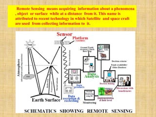
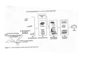
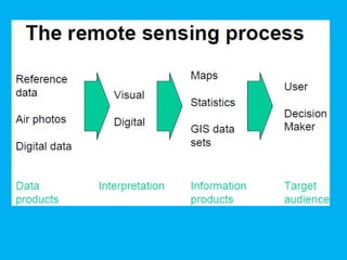
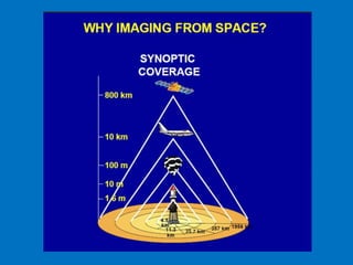
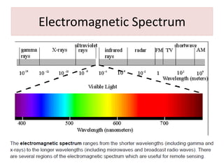
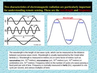
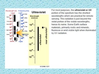
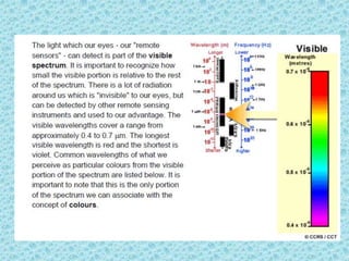
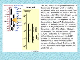
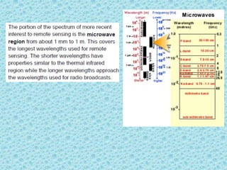
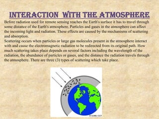
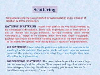
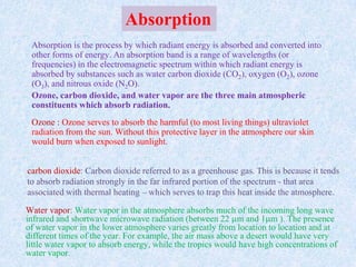
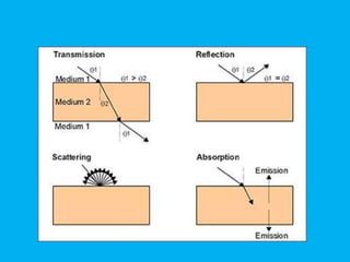
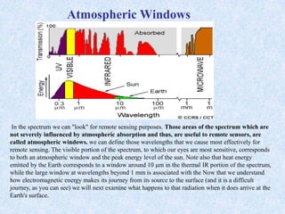
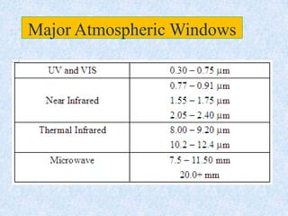
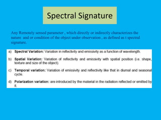
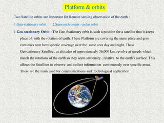
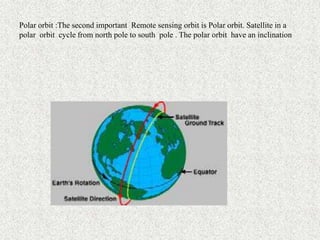
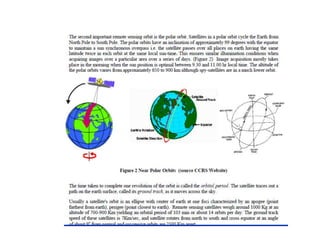
This document provides an overview of the basics of remote sensing. It defines remote sensing as acquiring information about an object without direct contact. It discusses key components of the remote sensing process including data acquisition, the electromagnetic spectrum, atmospheric interactions, spectral signatures, and satellite platforms and orbits. Remote sensing draws from many areas and plays an important role in monitoring the Earth through satellite imagery.
What is Remote Sensing?
Process of Remote Sensing
Electromagnetic Radiations
Electromagnetic Spectrum
Interaction with Atmosphere
Radiations-Target Interactions
Passive Vs Active Sensing
A remote sensing system uses a detector to sense the reflected or emitted energy from the earth's surface, perhaps modified by the intervening atmosphere. The sensor can be on a satellite, aircraft, or drone. The sensor turns the energy into a voltage, which an analog to digital converter turns into a single integer value (called the Digital Number, or DN) for the energy. Alternatively a digital detector can store the DN directly. We can then display this value with an appropriate color to build up an image of the region sensed by the system. The DN represents the energy sensed by the sensor in a particular part of the electromagnetic spectrum, emitted or reflected from a particular region. The principles can also be applied to sonar imagery, especially useful in water where sound penetrates readily whereas electromagnetic energy attenuates rapidly.
Definitions,
Remote sensing systems can be active or passive: active systems put out their own source of energy (a large "flash bulb") whereas passive systems use solar energy reflected from the surface or thermal energy emitted by the surface. Active systems can achieve higher resolution.
Satellite resolution considers four things: spatial, spectral, radiometric, and temporal resolution.
Electromagnetic radiation and the atmosphere control many aspects of a remote sensing system.
Satellite orbits determine many characteristics of the imagery, what the satellite sees, and how often it revisits an area.
The signal to noise ratio is important for the design of remote sensing systems.
Satellite band tradeoffs.
Interpreting satellite reflectance patterns and images uses various statistical measures to assess surface properties in the image.
The colors used on the display are gray shading for single bands, and RGB for multi-band composites. We can also perform image merge and sharpening to combine the advantages of both panchromatic (higher spatial resolution) and color imagery (better differentiation of surface materials).
Keys for image analysis
Hyperspectral imagery
Spectral reflectance library--different materials reflect radiation differently
Types of Platforms
1. Airbrone Platforms
2. Spacebrone Platforms
Platforms are Vital Role in remote sensing data acquisition
Necessary to correct the position the remote sensors that collect data from the objects of interest
This is all about remote sensing. Remote sensing is the acquisition of information about an object or phenomenon without making physical contact with the object and thus in contrast to on-site observation, especially the Earth.Remote sensing is the process of detecting and monitoring the physical characteristics of an area by measuring its reflected and emitted radiation at a distance from the targeted area. Special cameras collect remotely sensed imagesof the Earth, which help researchers "sense" things about the Earth.
REMOTE SENSING A VERY USEFUL TECHNOLOGY TO MANKINDkaushikakumar
Hi! I am Kaushika i have given a clear explanation about remotesensing and its types.I have aso explained about the advantages of remote sensing technology.I hope it will be very useful for u.
IMAGE INTERPRETATION
Act of examining images to identify objects and judge their significance.
Information extraction process from the images.
An interpreter is a specialist trained in study of photography or imagery, in addition to his own discipline.
Aerial photographs and remote Sensing images employ electro magnetic energy as the mean of detecting and measuring target characteristics.
Involves a considerable amount of subjective judgment.
Highly dependent on capability of mind to generalize.
Takes place at different levels of complexity.
A geographic information system (GIS) is a system designed to capture, store, manipulate, analyze, manage, and present all types of geographical data. The acronym GIS is sometimes used for geographical information science or geospatial information studies to refer to the academic discipline or career of working with geographic information systems and is a large domain within the broader academic discipline of Geoinformatics. In the simplest terms, GIS is the merging of cartography, statistical analysis, and computer science technology.
This is presentation is intended for middle school students. It provides a short introduction to GIS and how to use GIS in the real-world.
ArcGIS Explorer is the software used to demonstrate concepts.
45 minutes + 15 minutes demo
Download ArcGIS Explorer here...
http://www.esri.com/software/arcgis/explorer/
Remote sensing and aerial photography study notes. Including concept and history of RS, visual image interpretation, digital image interpretation, application of RS, digital imaging, application of remote sensing etc.
physics of remote sensing,ideal remote sensing,swath,platform,sensor,orbit and its characteristics,electromagnetic radiations,EMR solar radiations and its application,shortwave and long waves,spectrul reflectance curve, resolution AND multi concept,FCC,
Introduction to Remote Sensing- Remote sensing” is the science (and to some e...Ange Felix NSANZIYERA
"Remote sensing” is the science (and to some extent, art) of acquiring information about the Earth's surface without actually being in contact with it. This is done by sensing and recording reflected or emitted energy and processing, analyzing, and applying that information."
In much of remote sensing, the process involves an interaction between incident radiationand the targets of interest. This is exemplified by the use of imaging systems where thefollowing seven elements are involved. Note, however that remote sensing also involves thesensing of emitted energy and the use of non-imaging sensors.
APPLICATION OF REMOTE SENSING AND GIS IN AGRICULTURELagnajeetRoy
India is a country that depends on agriculture. Today in this era of technological supremacy, agriculture is also using different new technologies like some robotic machinery to remote sensing and Geographical Information System (GIS) for the betterment of agriculture. It is easy to get the information about that area where human cannot check the condition everyday and help in gathering the data with the help of remote sensing. Whereas GIS helps in preparation of map that shows an accurate representation of data we get through remote sensing. From disease estimation to stress factor due to water, from ground water quality index to acreage estimation in various way agriculture is being profited by the application of remote sensing and GIS in agriculture. The applications of those software or techniques are very new to the agriculture domain still much more exploration is needed in this part. New software’s are developing in different parts of the world and remote sensing. Today farmers understand the beneficiaries of these kinds of techniques to the farm field which help in increasing productivity that will help future generation as technology is hype in traditional system of farming.
Operation “Blue Star” is the only event in the history of Independent India where the state went into war with its own people. Even after about 40 years it is not clear if it was culmination of states anger over people of the region, a political game of power or start of dictatorial chapter in the democratic setup.
The people of Punjab felt alienated from main stream due to denial of their just demands during a long democratic struggle since independence. As it happen all over the word, it led to militant struggle with great loss of lives of military, police and civilian personnel. Killing of Indira Gandhi and massacre of innocent Sikhs in Delhi and other India cities was also associated with this movement.
Students, digital devices and success - Andreas Schleicher - 27 May 2024..pptxEduSkills OECD
Andreas Schleicher presents at the OECD webinar ‘Digital devices in schools: detrimental distraction or secret to success?’ on 27 May 2024. The presentation was based on findings from PISA 2022 results and the webinar helped launch the PISA in Focus ‘Managing screen time: How to protect and equip students against distraction’ https://www.oecd-ilibrary.org/education/managing-screen-time_7c225af4-en and the OECD Education Policy Perspective ‘Students, digital devices and success’ can be found here - https://oe.cd/il/5yV
How to Create Map Views in the Odoo 17 ERPCeline George
The map views are useful for providing a geographical representation of data. They allow users to visualize and analyze the data in a more intuitive manner.
Read| The latest issue of The Challenger is here! We are thrilled to announce that our school paper has qualified for the NATIONAL SCHOOLS PRESS CONFERENCE (NSPC) 2024. Thank you for your unwavering support and trust. Dive into the stories that made us stand out!
The Roman Empire A Historical Colossus.pdfkaushalkr1407
The Roman Empire, a vast and enduring power, stands as one of history's most remarkable civilizations, leaving an indelible imprint on the world. It emerged from the Roman Republic, transitioning into an imperial powerhouse under the leadership of Augustus Caesar in 27 BCE. This transformation marked the beginning of an era defined by unprecedented territorial expansion, architectural marvels, and profound cultural influence.
The empire's roots lie in the city of Rome, founded, according to legend, by Romulus in 753 BCE. Over centuries, Rome evolved from a small settlement to a formidable republic, characterized by a complex political system with elected officials and checks on power. However, internal strife, class conflicts, and military ambitions paved the way for the end of the Republic. Julius Caesar’s dictatorship and subsequent assassination in 44 BCE created a power vacuum, leading to a civil war. Octavian, later Augustus, emerged victorious, heralding the Roman Empire’s birth.
Under Augustus, the empire experienced the Pax Romana, a 200-year period of relative peace and stability. Augustus reformed the military, established efficient administrative systems, and initiated grand construction projects. The empire's borders expanded, encompassing territories from Britain to Egypt and from Spain to the Euphrates. Roman legions, renowned for their discipline and engineering prowess, secured and maintained these vast territories, building roads, fortifications, and cities that facilitated control and integration.
The Roman Empire’s society was hierarchical, with a rigid class system. At the top were the patricians, wealthy elites who held significant political power. Below them were the plebeians, free citizens with limited political influence, and the vast numbers of slaves who formed the backbone of the economy. The family unit was central, governed by the paterfamilias, the male head who held absolute authority.
Culturally, the Romans were eclectic, absorbing and adapting elements from the civilizations they encountered, particularly the Greeks. Roman art, literature, and philosophy reflected this synthesis, creating a rich cultural tapestry. Latin, the Roman language, became the lingua franca of the Western world, influencing numerous modern languages.
Roman architecture and engineering achievements were monumental. They perfected the arch, vault, and dome, constructing enduring structures like the Colosseum, Pantheon, and aqueducts. These engineering marvels not only showcased Roman ingenuity but also served practical purposes, from public entertainment to water supply.
Synthetic Fiber Construction in lab .pptxPavel ( NSTU)
Synthetic fiber production is a fascinating and complex field that blends chemistry, engineering, and environmental science. By understanding these aspects, students can gain a comprehensive view of synthetic fiber production, its impact on society and the environment, and the potential for future innovations. Synthetic fibers play a crucial role in modern society, impacting various aspects of daily life, industry, and the environment. ynthetic fibers are integral to modern life, offering a range of benefits from cost-effectiveness and versatility to innovative applications and performance characteristics. While they pose environmental challenges, ongoing research and development aim to create more sustainable and eco-friendly alternatives. Understanding the importance of synthetic fibers helps in appreciating their role in the economy, industry, and daily life, while also emphasizing the need for sustainable practices and innovation.
2024.06.01 Introducing a competency framework for languag learning materials ...Sandy Millin
http://sandymillin.wordpress.com/iateflwebinar2024
Published classroom materials form the basis of syllabuses, drive teacher professional development, and have a potentially huge influence on learners, teachers and education systems. All teachers also create their own materials, whether a few sentences on a blackboard, a highly-structured fully-realised online course, or anything in between. Despite this, the knowledge and skills needed to create effective language learning materials are rarely part of teacher training, and are mostly learnt by trial and error.
Knowledge and skills frameworks, generally called competency frameworks, for ELT teachers, trainers and managers have existed for a few years now. However, until I created one for my MA dissertation, there wasn’t one drawing together what we need to know and do to be able to effectively produce language learning materials.
This webinar will introduce you to my framework, highlighting the key competencies I identified from my research. It will also show how anybody involved in language teaching (any language, not just English!), teacher training, managing schools or developing language learning materials can benefit from using the framework.
2024.06.01 Introducing a competency framework for languag learning materials ...
Basic of Remote Sensing
1. Basic’s of Remote Sensing
Praveen Vishwakarma
Diploma in Remote Sensing &
Geoinformatics
Dept. of Remote Sensing & Geoinformatics
MDS University, Ajmer
Submitted to:: Dr. Sarvesh Palriya
H.O.D. Remote Sensing Dept.
2. Definitions
Remote Sensing can be defined as the acquisition and recording of information about an
object without being indirect contact with that object.
Remote Sensing, process of obtaining information about land, water, or an object without
any physical contact between the sensor and the subject of analysis.
Remote Sensing is an extensive science, drawing from many areas for support and
development. It depends greatly on the support of governments and private industries
worldwide. Satellite and digital imagery play an important role in remote sensing;
providing information about the land studied
The benefits of remote sensing continue to arise. It can be used to access hard to
reach areas for fieldwork, and provides a more detailed, permanent and objective
survey that offers a different perspective. Air photos are still favored and easily
accessible sources of information for classification
3. Remote Sensing means acquiring information about a phenomena
, object or surface while at a distance from it. This name is
attributed to recent technology in which Satellite and space craft
are used from collecting information to it.
6. 1. Energy Source or Illumination – The first requirement for remote sensing is to
have an energy source which illuminates or provides electromagnetic energy to the
target of interest.
2. Radiation and the Atmosphere– As the energy travels from its source to the
target, it will come in contact with and interact with the atmosphere it passes
through. This interaction may take place a second time as the energy travels from
the target to the sensor.
3. Interaction with the Target - Once the energy makes its way to the target
through the atmosphere, it interacts with the target depending on the properties of
both the target and the radiation.
4. Recording of Energy by the Sensor - After the energy has been scattered by, or
emitted from the target, we require a sensor (remote - not in contact with the target)
to collect and record the electromagnetic radiation.
5. Transmission, Reception, and Processing - The energy recorded by the sensor
has to be transmitted, often in electronic form, to a receiving and processing station
where the data are processed into an image (hardcopy and/or digital).
7. Data Analysis
1. Interpretation and Analysis - The processed image is interpreted, visually
and/or digitally or electronically, to extract information about the target which was
illuminated.
2. Application - The final element of the remote sensing process is achieved
when we apply the information we have been able to extract from the imagery
about the target in order to better understand it, reveal some new information, or
assist in solving a particular problem.
These seven elements comprise the remote sensing process from beginning to
end. We will be covering all of these in sequential order
11. Two characteristics of electromagnetic radiation are particularly important
for understanding remote sensing. These are the wavelength and frequency.
12.
13.
14.
15.
16. Interaction with THE Atmosphere
Before radiation used for remote sensing reaches the Earth's surface it has to travel through
some distance of the Earth's atmosphere. Particles and gases in the atmosphere can affect
the incoming light and radiation. These effects are caused by the mechanisms of scattering
and absorption.
Scattering occurs when particles or large gas molecules present in the atmosphere interact
with and cause the electromagnetic radiation to be redirected from its original path. How
much scattering takes place depends on several factors including the wavelength of the
radiation, the abundance of particles or gases, and the distance the radiation travels through
the atmosphere. There are three (3) types of scattering which take place.
17. Scattering
Atmospheric scattering is accomplished through absorption and re-emission of
radiation by atoms or molecules.
Rayleigh scattering : occurs when particles are very small compared to
the wavelength of the radiation. These could be particles such as small specks of
dust or nitrogen and oxygen molecules. Rayleigh scattering causes shorter
wavelengths of energy to be scattered much more than longer wavelengths.
Rayleigh scattering is the dominant scattering mechanism in the upper atmosphere.
The fact that the sky appears "blue" during the day is because of this phenomenon.
Mie scattering :occurs when the particles are just about the same size as the
wavelength of the radiation. Dust, pollen, smoke and water vapor are common
causes of Mie scattering which tends to affect longer wavelengths than those
affected by Rayleigh scattering.
Non-selective scattering: This occurs when the particles are much larger
than the wavelength of the radiation. Water droplets and large dust particles can
cause this type of scattering. Nonselective scattering gets its name from the fact
that all wavelengths are scattered about equally.
18.
19. Absorption
Absorption is the process by which radiant energy is absorbed and converted into
other forms of energy. An absorption band is a range of wavelengths (or
frequencies) in the electromagnetic spectrum within which radiant energy is
absorbed by substances such as water carbon dioxide (CO2), oxygen (O2), ozone
(O3), and nitrous oxide (N2O).
Ozone, carbon dioxide, and water vapor are the three main atmospheric
constituents which absorb radiation.
Ozone : Ozone serves to absorb the harmful (to most living things) ultraviolet
radiation from the sun. Without this protective layer in the atmosphere our skin
would burn when exposed to sunlight.
carbon dioxide: Carbon dioxide referred to as a greenhouse gas. This is because it tends
to absorb radiation strongly in the far infrared portion of the spectrum - that area
associated with thermal heating – which serves to trap this heat inside the atmosphere.
Water vapor: Water vapor in the atmosphere absorbs much of the incoming long wave
infrared and shortwave microwave radiation (between 22 m and 1 m ). The presence
of water vapor in the lower atmosphere varies greatly from location to location and at
different times of the year. For example, the air mass above a desert would have very
little water vapor to absorb energy, while the tropics would have high concentrations of
water vapor.
20.
21. Atmospheric Windows
In the spectrum we can "look" for remote sensing purposes. Those areas of the spectrum which are
not severely influenced by atmospheric absorption and thus, are useful to remote sensors, are
called atmospheric windows. we can define those wavelengths that we cause most effectively for
remote sensing. The visible portion of the spectrum, to which our eyes are most sensitive, corresponds
to both an atmospheric window and the peak energy level of the sun. Note also that heat energy
emitted by the Earth corresponds to a window around 10 μm in the thermal IR portion of the spectrum,
while the large window at wavelengths beyond 1 mm is associated with the Now that we understand
how electromagnetic energy makes its journey from its source to the surface (and it is a difficult
journey, as you can see) we will next examine what happens to that radiation when it does arrive at the
Earth's surface.
23. Spectral Signature
Any Remotely sensed parameter , which directly or indirectly characterizes the
nature and or condition of the object under observation , as defined as t spectral
signature.
24.
25.
26.
27.
28. Platform & orbits
Two Satellite orbits are important for Remote sensing observation of the earth :
1.Geo-stationary orbit 2.Sunsynchronous - polar orbit
1.Geo-stationary Orbit : The Geo-Stationary orbit is such a position for a satellite that it keeps
place of with the rotation of earth. These Platform are covering the same place and give
continues near hemispheric coverage over the same area day and night. These
Geostationary Satellite , at altitudes of approximately 36,000 km. revolve at speeds which
match the rotations of the earth so they seem stationary , relative to the earth’s surface. This
allows the Satellites to observe and collect information continuously over specific areas.
These are the main used for communications and metrological application.
29. Polar orbit :The second important Remote sensing orbit is Polar orbit. Satellite in a
polar orbit cycle from north pole to south pole . The polar orbit have an inclination