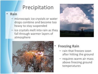
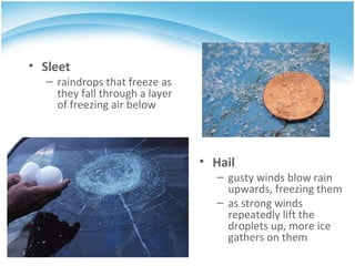
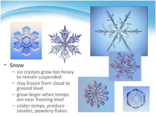
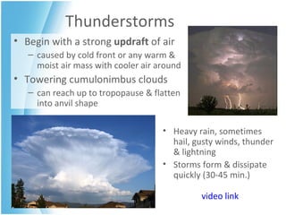
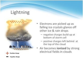
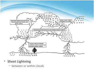
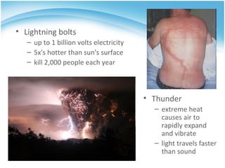
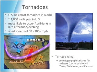
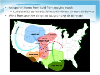
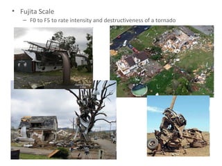
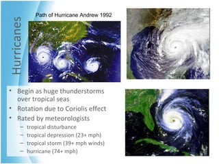
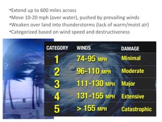
PRECIPITATION &  SEVERE  WEATHER
Precipitation Rain microscopic ice crystals or water drops combine and become too heavy to stay suspended  ice crystals melt into rain as they fall through warmer layers of atmosphere Freezing Rain rain that freezes soon after hitting the ground requires warm air mass above freezing ground temperatures
Hail gusty winds blow rain upwards, freezing them as strong winds repeatedly lift the droplets up, more ice gathers on them Sleet raindrops that freeze as they fall through a layer of freezing air below
Snow ice crystals grow too heavy to remain suspended stay frozen from cloud to ground level grow larger when temps. are near freezing level colder temps. produce smaller, powdery flakes
Thunderstorms Begin with a strong  updraft  of air caused by cold front or any warm & moist air mass with cooler air around Towering cumulonimbus clouds  can reach up to tropopause & flatten into anvil shape Heavy rain, sometimes hail, gusty winds, thunder & lightning  Storms form & dissipate quickly (30-45 min.) video link
Lightning Electrons are picked up as falling ice crystals glance off other ice & rain drops negative charges build up at bottom of storm cell positive charges left behind  at the top of the cloud  Air becomes  ionized  by strong electrical fields in clouds
Stepped Leader jerky, stepwise movement of negative charges towards earth Return Stroke positive charges rush up to meet the negative charges  brightest, hottest and loudest part of the lightning strike
Cumulus Clouds
Sheet Lightning between or within clouds
Lightning bolts up to 1 billion volts electricity 5x's hotter than sun's surface kill 2,000 people each year Thunder extreme heat causes air to rapidly expand and vibrate light travels faster than sound
Tornadoes U.S. has most tornadoes in world ~ 1,000 each year in U.S. most likely to occur April-June in late afternoon/evening wind speeds of 50 - 300+ mph Tornado Alley prime geographical area for twisters (centered around Texas, Oklahoma, and Kansas)
An updraft forms from cold front moving south Cumulonimbus storm clouds form as warm/moist air meets cold/dry air Wind from another direction causes rising air to rotate
Fujita Scale F0 to F5 to rate intensity and destructiveness of a tornado
Waterspout tornado over water Dust devil smaller, weaker version of a tornado (dry, not humid)
Hurricanes Begin as huge thunderstorms over tropical seas Rotation due to Coriolis effect Rated by meteorologists tropical disturbance tropical depression (23+ mph) tropical storm (39+ mph winds) hurricane (74+ mph) Path of Hurricane Andrew 1992
Eye center of hurricane low pressure center about 10 miles wide calm winds, sunny skies Rain Bands lines of thunderstorm cells rotating around the eye spiral slowly inward, becoming more intense near the eye
Extend up to 600 miles across Move 10-20 mph (over water), pushed by prevailing winds Weaken over land into thunderstorms (lack of warm/moist air) Categorized based on wind speed and destructiveness
Damage from:  high winds (up to 200 mph)  storm surge  flooding   (ocean levels 25 ft above normal) caused by high winds & hurricane eye's low pressure "bulge"

Severe Weather

  • 1.
    PRECIPITATION & SEVERE WEATHER
  • 2.
    Precipitation Rain microscopicice crystals or water drops combine and become too heavy to stay suspended ice crystals melt into rain as they fall through warmer layers of atmosphere Freezing Rain rain that freezes soon after hitting the ground requires warm air mass above freezing ground temperatures
  • 3.
    Hail gusty windsblow rain upwards, freezing them as strong winds repeatedly lift the droplets up, more ice gathers on them Sleet raindrops that freeze as they fall through a layer of freezing air below
  • 4.
    Snow ice crystalsgrow too heavy to remain suspended stay frozen from cloud to ground level grow larger when temps. are near freezing level colder temps. produce smaller, powdery flakes
  • 5.
    Thunderstorms Begin witha strong updraft of air caused by cold front or any warm & moist air mass with cooler air around Towering cumulonimbus clouds can reach up to tropopause & flatten into anvil shape Heavy rain, sometimes hail, gusty winds, thunder & lightning Storms form & dissipate quickly (30-45 min.) video link
  • 6.
    Lightning Electrons arepicked up as falling ice crystals glance off other ice & rain drops negative charges build up at bottom of storm cell positive charges left behind at the top of the cloud Air becomes ionized by strong electrical fields in clouds
  • 7.
    Stepped Leader jerky,stepwise movement of negative charges towards earth Return Stroke positive charges rush up to meet the negative charges brightest, hottest and loudest part of the lightning strike
  • 8.
  • 9.
    Sheet Lightning betweenor within clouds
  • 10.
    Lightning bolts upto 1 billion volts electricity 5x's hotter than sun's surface kill 2,000 people each year Thunder extreme heat causes air to rapidly expand and vibrate light travels faster than sound
  • 11.
    Tornadoes U.S. hasmost tornadoes in world ~ 1,000 each year in U.S. most likely to occur April-June in late afternoon/evening wind speeds of 50 - 300+ mph Tornado Alley prime geographical area for twisters (centered around Texas, Oklahoma, and Kansas)
  • 12.
    An updraft formsfrom cold front moving south Cumulonimbus storm clouds form as warm/moist air meets cold/dry air Wind from another direction causes rising air to rotate
  • 13.
    Fujita Scale F0to F5 to rate intensity and destructiveness of a tornado
  • 14.
    Waterspout tornado overwater Dust devil smaller, weaker version of a tornado (dry, not humid)
  • 15.
    Hurricanes Begin ashuge thunderstorms over tropical seas Rotation due to Coriolis effect Rated by meteorologists tropical disturbance tropical depression (23+ mph) tropical storm (39+ mph winds) hurricane (74+ mph) Path of Hurricane Andrew 1992
  • 16.
    Eye center ofhurricane low pressure center about 10 miles wide calm winds, sunny skies Rain Bands lines of thunderstorm cells rotating around the eye spiral slowly inward, becoming more intense near the eye
  • 17.
    Extend up to600 miles across Move 10-20 mph (over water), pushed by prevailing winds Weaken over land into thunderstorms (lack of warm/moist air) Categorized based on wind speed and destructiveness
  • 18.
    Damage from: high winds (up to 200 mph) storm surge flooding (ocean levels 25 ft above normal) caused by high winds & hurricane eye's low pressure "bulge"