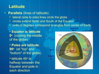
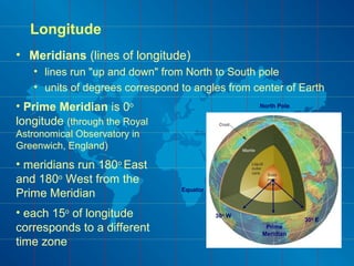
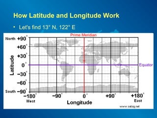
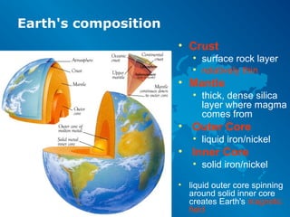
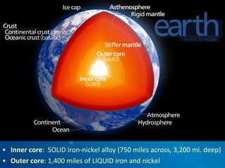
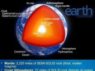
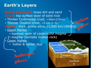
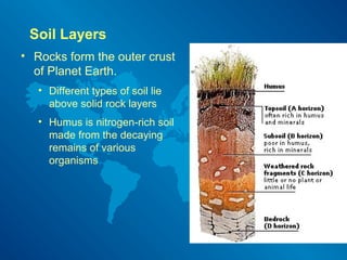
Earth & Space ScienceEarth & Space Science
The Geosphere I
Mapping the World
Science is Organized Knowledge
In your l ab not ebook, pl ease answer as best you
can:
1. Name the four spheres of the earth and what each category generally includes.
• Geosphere – rocks, Hydrosphere – water, Atmosphere – air, Biosphere – living things
1. What is the #1, first thing you can do to succeed in science class this year?
• Start early! (don’t procrastinate – have a plan/schedule for doing homework)
3. Name one rule for lab safety.
• No baggy clothing, hair pulled back, read & follow directions, closed-toe shoes, no
eating during labs, place leftover materials/chemicals in designated containers, tidy
workspace, safety equipment – use it (know locations), report spills/hazards
4. List the four primary steps of the Scientific Method.
• Observation (research & propose a question)
• Hypothesis
• Experiment (design, perform, & collect data)
• Conclusion (analyze & share data)
4. What special science field trips do we have planned for this year?
• Mt. St. Helens tour, MHCC Planetarium show, and maybe an Estuary Canoe Paddle
Bonus Question: Where is Earth’s crust thinnest?
Oceanic crust, especially in deep trenches or where tectonic plates are spreading, is very thin.
Week 2
Review Quiz
Bubble Lab Results
What variables might have
affected the data?
World Geography Review
North
America
South
America
Africa
Australia/
Oceania
Asia
Europe
Antarctica
Pacific
Ocean
Atlantic
Ocean
Indian
Ocean
Arctic Ocean
Southern Ocean
Map Projections
• Cylindrical
• Conic
• Planar
Map Projections
• Mercator
• cylindrical projection
• Albers or Lambert
• conic projections
• Azimuthal
• planar projection
Map Features
• Compass Rose
• Colors & Symbols
• Legend (key)
• Labels
• Scale
The Compass Rose
• Naughty Elephants Squirt Water
Colors, Symbols, Legends & Labels
• Cartographers (mapmakers) use color and symbols
to identify different types of information.
• The map legend
(or map key) tells
what the colors
and symbols
mean.
• Labels name
cities, rivers,
mountains, points
of interest, etc.
Climate Map
• What information does this map key display?
Map Scale
• How many miles from Shreveport to Baton Rouge?
• First measure it on
the map.
• Then place your
ruler on the scale
and estimate.
OR
• Use this formula:
Scale Distance x Measured Length
Scale Length
100 mi x 2.1 in = 240 mi
.875 in
Explore Your World
• Working alone OR in small groups, complete the
Map Reading Activity in your lab notebooks.
• You must EACH complete the written activity.
YOU HAVE 10 MINUTES to COMPLETE THIS!
Topography = Elevation
• Topographic maps include contour lines to show the
shape and elevation of an area
Contour
Lines
• Approximately how tall is Able Hill?
• About how tall is Baker Hill?
• Which mountain is taller, and by about how much?
• How many meters of elevation are there between contour lines on the topographic map?
• Which mountain has steeper slopes?
• Are the contour lines closer together on Able Hill or Baker Hill?
Topographic
maps use
contour lines
to show
changes in
elevation.
• Intro to maps:
• nationalmap.gov video
Explore Your World
• Form into groups of 2 or 3
• Complete the Topographic Map activity pages.
YOU HAVE 7 MINUTES to COMPLETE THIS DRILL
Latitude & Longitude
• Coordinates that describe locations on Earth
• i.e. Guatemala is 15º 30' N and 90º 15' W
• latitude is always given first, followed by longitude
• Angles of arc
• o
= degrees
• ' = minutes
• " = seconds
20o
angle
0o
90o
180o
360o
• 60 min. in a degree
• 60 sec. in a minute
• 15º 30' = 15.5o
Latitude
• Parallels (lines of latitude)
• lateral (side to side) lines circle the globe
• circles extend North and South of the Equator
• units of degrees correspond to angles from center of Earth
20o
N
Equator
0o
North Pole
90o
N
• Equator is latitude
0o
(circling the middle
of the globe)
• Poles are latitude
90o
(at "top" and
"bottom" of the globe)
• latitude 45o
is
halfway between the
Equator and pole in
each direction
Longitude
• Meridians (lines of longitude)
• lines run "up and down" from North to South pole
• units of degrees correspond to angles from center of Earth
Equator
North Pole
Prime
Meridian
30o
E
30o
W
• Prime Meridian is 0o
longitude (through the Royal
Astronomical Observatory in
Greenwich, England)
• meridians run 180o
East
and 180o
West from the
Prime Meridian
• each 15o
of longitude
corresponds to a different
time zone
How Latitude and Longitude Work
• Let's find 13° N, 122° E
Prime Meridian
Equator
Earth's composition
• Crust
• surface rock layer
• relatively thin
• Mantle
• thick, dense silica
layer where magma
comes from
• Outer Core
• liquid iron/nickel
• Inner Core
• solid iron/nickel
• liquid outer core spinning
around solid inner core
creates Earth's magnetic
field
• Inner core: SOLID iron-nickel alloy (750 miles across, 3,200 mi. deep)
• Outer core: 1,400 miles of LIQUID iron and nickel
• Mantle: 2,220 miles of SEMI-SOLID rock (thick, molten
magma)
Earth's Layers
Soil & Sediment: loose dirt and sand
Crust: top surface layer of solid rock
• Thicker Continental crust, ~30km (19mi)
• Thinner Oceanic crust, ~5 km (2 mi)
Mantle: thick, dense silica, (2,900 km/1800mi)
• Upper Mantle
• topmost layer of cooler/solid magma
• magma (partially molten rock)
• Lower Mantle
• hotter & harder due to pressure
Lithos
phere
Asthenos
phere
Mantle = 1800
miles
Outer Core
= 1300 milesInner
Core =
800 miles
Crust = 1
to 100
miles
Soil Layers
• Rocks form the outer crust
of Planet Earth.
• Different types of soil lie
above solid rock layers
• Humus is nitrogen-rich soil
made from the decaying
remains of various
organisms
Experiment 2
Bubble Trouble
• Observation:
• What do you know?
• What do you want to
know more about?
• Hypothesis:
• What do you think will
happen & why?
• Experiment:
• Record
data/observations
• What happened?
• Conclusion:
• Does the data support
your hypothesis?
• What's next?

Exploring the Geosphere

  • 1.
    Earth & SpaceScienceEarth & Space Science The Geosphere I Mapping the World Science is Organized Knowledge
  • 2.
    In your lab not ebook, pl ease answer as best you can: 1. Name the four spheres of the earth and what each category generally includes. • Geosphere – rocks, Hydrosphere – water, Atmosphere – air, Biosphere – living things 1. What is the #1, first thing you can do to succeed in science class this year? • Start early! (don’t procrastinate – have a plan/schedule for doing homework) 3. Name one rule for lab safety. • No baggy clothing, hair pulled back, read & follow directions, closed-toe shoes, no eating during labs, place leftover materials/chemicals in designated containers, tidy workspace, safety equipment – use it (know locations), report spills/hazards 4. List the four primary steps of the Scientific Method. • Observation (research & propose a question) • Hypothesis • Experiment (design, perform, & collect data) • Conclusion (analyze & share data) 4. What special science field trips do we have planned for this year? • Mt. St. Helens tour, MHCC Planetarium show, and maybe an Estuary Canoe Paddle Bonus Question: Where is Earth’s crust thinnest? Oceanic crust, especially in deep trenches or where tectonic plates are spreading, is very thin. Week 2 Review Quiz
  • 3.
    Bubble Lab Results Whatvariables might have affected the data?
  • 4.
  • 5.
  • 6.
    Map Projections • Mercator •cylindrical projection • Albers or Lambert • conic projections • Azimuthal • planar projection
  • 7.
    Map Features • CompassRose • Colors & Symbols • Legend (key) • Labels • Scale
  • 8.
    The Compass Rose •Naughty Elephants Squirt Water
  • 9.
    Colors, Symbols, Legends& Labels • Cartographers (mapmakers) use color and symbols to identify different types of information. • The map legend (or map key) tells what the colors and symbols mean. • Labels name cities, rivers, mountains, points of interest, etc.
  • 10.
    Climate Map • Whatinformation does this map key display?
  • 11.
    Map Scale • Howmany miles from Shreveport to Baton Rouge? • First measure it on the map. • Then place your ruler on the scale and estimate. OR • Use this formula: Scale Distance x Measured Length Scale Length 100 mi x 2.1 in = 240 mi .875 in
  • 12.
    Explore Your World •Working alone OR in small groups, complete the Map Reading Activity in your lab notebooks. • You must EACH complete the written activity. YOU HAVE 10 MINUTES to COMPLETE THIS!
  • 13.
    Topography = Elevation •Topographic maps include contour lines to show the shape and elevation of an area
  • 14.
    Contour Lines • Approximately howtall is Able Hill? • About how tall is Baker Hill? • Which mountain is taller, and by about how much? • How many meters of elevation are there between contour lines on the topographic map? • Which mountain has steeper slopes? • Are the contour lines closer together on Able Hill or Baker Hill? Topographic maps use contour lines to show changes in elevation.
  • 15.
    • Intro tomaps: • nationalmap.gov video
  • 16.
    Explore Your World •Form into groups of 2 or 3 • Complete the Topographic Map activity pages. YOU HAVE 7 MINUTES to COMPLETE THIS DRILL
  • 17.
    Latitude & Longitude •Coordinates that describe locations on Earth • i.e. Guatemala is 15º 30' N and 90º 15' W • latitude is always given first, followed by longitude • Angles of arc • o = degrees • ' = minutes • " = seconds 20o angle 0o 90o 180o 360o • 60 min. in a degree • 60 sec. in a minute • 15º 30' = 15.5o
  • 18.
    Latitude • Parallels (linesof latitude) • lateral (side to side) lines circle the globe • circles extend North and South of the Equator • units of degrees correspond to angles from center of Earth 20o N Equator 0o North Pole 90o N • Equator is latitude 0o (circling the middle of the globe) • Poles are latitude 90o (at "top" and "bottom" of the globe) • latitude 45o is halfway between the Equator and pole in each direction
  • 19.
    Longitude • Meridians (linesof longitude) • lines run "up and down" from North to South pole • units of degrees correspond to angles from center of Earth Equator North Pole Prime Meridian 30o E 30o W • Prime Meridian is 0o longitude (through the Royal Astronomical Observatory in Greenwich, England) • meridians run 180o East and 180o West from the Prime Meridian • each 15o of longitude corresponds to a different time zone
  • 20.
    How Latitude andLongitude Work • Let's find 13° N, 122° E Prime Meridian Equator
  • 22.
    Earth's composition • Crust •surface rock layer • relatively thin • Mantle • thick, dense silica layer where magma comes from • Outer Core • liquid iron/nickel • Inner Core • solid iron/nickel • liquid outer core spinning around solid inner core creates Earth's magnetic field
  • 23.
    • Inner core:SOLID iron-nickel alloy (750 miles across, 3,200 mi. deep) • Outer core: 1,400 miles of LIQUID iron and nickel
  • 24.
    • Mantle: 2,220miles of SEMI-SOLID rock (thick, molten magma)
  • 25.
    Earth's Layers Soil &Sediment: loose dirt and sand Crust: top surface layer of solid rock • Thicker Continental crust, ~30km (19mi) • Thinner Oceanic crust, ~5 km (2 mi) Mantle: thick, dense silica, (2,900 km/1800mi) • Upper Mantle • topmost layer of cooler/solid magma • magma (partially molten rock) • Lower Mantle • hotter & harder due to pressure Lithos phere Asthenos phere
  • 26.
    Mantle = 1800 miles OuterCore = 1300 milesInner Core = 800 miles Crust = 1 to 100 miles
  • 27.
    Soil Layers • Rocksform the outer crust of Planet Earth. • Different types of soil lie above solid rock layers • Humus is nitrogen-rich soil made from the decaying remains of various organisms
  • 29.
    Experiment 2 Bubble Trouble •Observation: • What do you know? • What do you want to know more about? • Hypothesis: • What do you think will happen & why? • Experiment: • Record data/observations • What happened? • Conclusion: • Does the data support your hypothesis? • What's next?

Editor's Notes

  • #5 Continents, then oceans. Middle East is a part of Asia, Greenland is a part of North America The Southern Ocean is the world's newest and fourth-largest ocean. In the spring of 2000, the International Hydrographic Organization decided to delimit a fifth ocean. In doing so, boundaries were taken from the Pacific, Atlantic and Indian Oceans. The Southern Ocean extends from the coast of Antarctica to 60 degrees south latitude. It has a total area of 7,848,300 square miles (20,327,000 sq km) and an average depth ranging from 13,100 to 16,400 feet (4,000 to 5,000 m). The deepest point in the Southern Ocean is unnamed but it is in the south end of the South Sandwich Trench and has a depth of -23,737 feet (-7,235 m). The world's largest ocean current, the Antarctic Circumpolar Current moves east and is 13,049 feet (21,000 km) in length.
  • #6 Civil war battles, Oregon trail and Pearl Harbor
  • #8 All are most accurate at points which touch the globe. Mercator is a cylindrical projection useful during sea navigation because the cardinal directions (N, S, E, W) are displayed as straight lines. Conic projections are generally used for smaller areas, such as maps of the U.S. Azimuthal projections are helpful for mapping air-travel routes because they can accurately show the shortest distance between two points.
  • #10 Never Eat Soggy Waffles
  • #12 Mapmakers, use colors to show different climate or precipitation zones.
  • #13 If all we had was this map and we happened to be in Shreveport, LA, it would be fairly simple to determine how many miles we'd need to drive before reaching Baton Rouge (the state capitol).
  • #14 Get into groups of 2 or 3. Find something in your book/atlas that intrigues you. Formulate a question you have about whatever you found (what would you like to know?). Share your question with your group. You have 5 minutes to complete this drill Ready Set GO! Now write your question in your notebook.
  • #15 Lines that are close together indicate steep terrain, and lines that are far apart indicate flat terrain. Very important for hikers and military or anyone traveling off-road or through the wilderness.
  • #17 Columbia Gorge - if you needed to get from "25" to "30", the quickest path would not be a straight line. Look at roads, railroads and notice how many lines of elevation are crossed.
  • #18 Get into groups of 2 or 3. Find something in your book/atlas that intrigues you. Formulate a question you have about whatever you found (what would you like to know?). Share your question with your group. You have 5 minutes to complete this drill Ready Set GO! Now write your question in your notebook.
  • #19 30 minutes is the same as ½ a degree, so it's easier to use decimals.
  • #20 45th Parallel
  • #21 Where do the Prime Meridian and the Equator cross? 360degrees/24hours=15
  • #22 Where are the Prime Meridian and Equator? The Philippines
  • #25 Gravity: a result of Earth's MASS Magnetism: a result of the LIQUID outer core spinning around the SOLID iron inner core ~4,000 miles to center of Earth's core
  • #26 Scale: 3,000 miles from Portland to Boston, 2,150 to Chicago, and 1,100 to San Diego
  • #27 There are very thin layers of the lithosphere (only 5 km thick), but they only exist beneath the deepest parts of the ocean. Now you know why we have not observed any section of the earth other than the lithosphere. The deepest that any drill has ever penetrated the lithosphere is 15 kilometers. Since drilling does not take place in the deep ocean, you can see that drilling has not come close to penetrating through the lithosphere. Mantle: like warm plastic, flows about 10cm per year.
  • #31 Density bars, scale optional: graduated cylinders & water - explain difference between volume, mass, and density - focus on mass