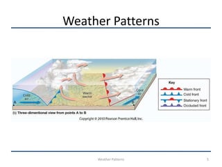
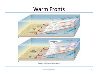
Weather Patterns
Weather Patterns
• Fronts- Are boundary surfaces that separate
  air masses of different densities.
• One air mass is usually warmer and often
  contains more moisture than the other air
  mass.
• However, fronts can form between any two
  contrasting air masses.
Weather Patterns
• Above the ground, the frontal surface slopes
  at a low angle.
• Warmer air overlies cooler air.
• In perfect conditions, air masses on both sides
  of the front move in the same direction and
  speed.
• In this situation, the fronts act as a barrier
  traveling along with the air masses.
Weather Patterns
• But in reality, the distribution of pressure
  across a front is such that one air mass moves
  faster than the other.
• So…… one air mass actively collides with the
  other.
• Norwegian meteorologists visualized these
  conditions as resembling a battle front, and so
  named them fronts.
Weather Patterns


     Weather Patterns   5
Weather Patterns
• Warm Fronts
    • When the surface (ground) position of a front moves in
      such a way that warm air occupies territory formerly
      covered by cooler air, denser air acts as a wedge on
      which lifting takes place.
    • Overrunning is the term applied to warm air gliding up
      along a cold air mass.
    • On a weather map, the surface position of a warm front
      is shown by a red line with red semi-circles protruding
      (sticking) into the cooler air.
Warm Fronts
• East of the Rockies (Rocky Mountains)
  maritime tropical (mT) air often enters the
  U.S. from the Gulf of Mexico.
• It often overruns receding cooler air.
• Less dense warmer air has a more difficult
  displacing heavier, cooler air.
• As a result, the boundary separating these air
  masses acquires a very gradual slope.
Warm Fronts
• The slope of a warm front is very gradual.
• As warm air rises over the retreating wedge of
  cooler air, it expands and cools adiabatically.
• This causes moisture to condense into clouds
  that often produce precipitation.
• The following cloud sequence (Figure 9-4a)
  typically precedes a warm front.
Warm Fronts


   Weather Patterns   9
Warm Fronts
• The first sign of an approaching warm front is
  cirrus clouds.
• These high clouds form where the overrunning
  warm air has ascended high up The wedge of cold
  air (about 600 miles – 1000 kilometers) ahead of
  the surface front.
• Another indication of an approaching warm front
  is the appearance of contrails.
• On a clear day when these contrails last for a long
  time, it’s a sign that comparatively warm, moist
  air is ascending overhead.
Warm Fronts
• As the front nears, cirrus clouds grade into
  cirrostratus clouds that blend into denser
  sheets of altostratus.
• About 180 miles (300 kilometers) ahead of the
  front, thicker stratus and nimbostratus clouds
  appear.
• Precipitation begins.
Warm Fronts
• Because of their relatively slow
  movement, warm fronts tend to produce light
  to moderate precipitation.
• But not always.
• When the overriding air mass is relatively dry
  (low dew point temperatures) there may be
  minimal cloud development and no
  precipitation.
Warm Fronts
• However, during the hot summer
  months, very moist air is often associated with
  an approaching warm front.
• If this unstable air is lifted sufficiently, it will
  freely rise on its own producing
  cumulonimbus clouds and thunderstorms.
• (Figure 9-4) Precipitation associated with a
  warm front occurs ahead of the surface
  position of the front.
Warm Fronts
• Some of the rain that falls through the cool air
  below the clouds evaporates.
• When this happens, the air directly beneath
  the cloud base become saturated and a
  stratus cloud deck develops.
• These clouds occasionally grow rapidly
  downward and causes problems for pilots of
  small aircraft that require visual landings. (No
  radar).
Warm Fronts
• Occasionally during the winter time, a
  relatively warm air mass is forced over a body
  of subfreezing air.
• When this happens, hazardous driving
  conditions may result.
• Raindrops become supercooled at they fall
  through the subfreezing air.
• Upon colliding with the road surface, the flash
  freeze to produce an icy layer called glaze.
Warm Fronts
• When a warm front passes, air temperatures
  gradually rise.
• The increase is most apparent when there is a
  large contrast between adjacent air masses.
• Moreover, a windshift from east to southwest is
  generally noticeable. (We’ll learn more about this
  later.
• Moisture content and stability of the encroaching
  warm air mass largely determines the time period
  required for clear skies to return.
Warm Fronts
• During the summer, cumulus and occasionally
  cumulonimbus clouds are embedded in the
  warm unstable air mass that follows the front.
• These clouds may produce precipitation which
  can be heavy but is usually scattered and of
  short duration.

Weather patterns

  • 1.
  • 2.
    Weather Patterns • Fronts-Are boundary surfaces that separate air masses of different densities. • One air mass is usually warmer and often contains more moisture than the other air mass. • However, fronts can form between any two contrasting air masses.
  • 3.
    Weather Patterns • Abovethe ground, the frontal surface slopes at a low angle. • Warmer air overlies cooler air. • In perfect conditions, air masses on both sides of the front move in the same direction and speed. • In this situation, the fronts act as a barrier traveling along with the air masses.
  • 4.
    Weather Patterns • Butin reality, the distribution of pressure across a front is such that one air mass moves faster than the other. • So…… one air mass actively collides with the other. • Norwegian meteorologists visualized these conditions as resembling a battle front, and so named them fronts.
  • 5.
    Weather Patterns Weather Patterns 5
  • 6.
    Weather Patterns • WarmFronts • When the surface (ground) position of a front moves in such a way that warm air occupies territory formerly covered by cooler air, denser air acts as a wedge on which lifting takes place. • Overrunning is the term applied to warm air gliding up along a cold air mass. • On a weather map, the surface position of a warm front is shown by a red line with red semi-circles protruding (sticking) into the cooler air.
  • 7.
    Warm Fronts • Eastof the Rockies (Rocky Mountains) maritime tropical (mT) air often enters the U.S. from the Gulf of Mexico. • It often overruns receding cooler air. • Less dense warmer air has a more difficult displacing heavier, cooler air. • As a result, the boundary separating these air masses acquires a very gradual slope.
  • 8.
    Warm Fronts • Theslope of a warm front is very gradual. • As warm air rises over the retreating wedge of cooler air, it expands and cools adiabatically. • This causes moisture to condense into clouds that often produce precipitation. • The following cloud sequence (Figure 9-4a) typically precedes a warm front.
  • 9.
    Warm Fronts Weather Patterns 9
  • 10.
    Warm Fronts • Thefirst sign of an approaching warm front is cirrus clouds. • These high clouds form where the overrunning warm air has ascended high up The wedge of cold air (about 600 miles – 1000 kilometers) ahead of the surface front. • Another indication of an approaching warm front is the appearance of contrails. • On a clear day when these contrails last for a long time, it’s a sign that comparatively warm, moist air is ascending overhead.
  • 11.
    Warm Fronts • Asthe front nears, cirrus clouds grade into cirrostratus clouds that blend into denser sheets of altostratus. • About 180 miles (300 kilometers) ahead of the front, thicker stratus and nimbostratus clouds appear. • Precipitation begins.
  • 12.
    Warm Fronts • Becauseof their relatively slow movement, warm fronts tend to produce light to moderate precipitation. • But not always. • When the overriding air mass is relatively dry (low dew point temperatures) there may be minimal cloud development and no precipitation.
  • 13.
    Warm Fronts • However,during the hot summer months, very moist air is often associated with an approaching warm front. • If this unstable air is lifted sufficiently, it will freely rise on its own producing cumulonimbus clouds and thunderstorms. • (Figure 9-4) Precipitation associated with a warm front occurs ahead of the surface position of the front.
  • 14.
    Warm Fronts • Someof the rain that falls through the cool air below the clouds evaporates. • When this happens, the air directly beneath the cloud base become saturated and a stratus cloud deck develops. • These clouds occasionally grow rapidly downward and causes problems for pilots of small aircraft that require visual landings. (No radar).
  • 15.
    Warm Fronts • Occasionallyduring the winter time, a relatively warm air mass is forced over a body of subfreezing air. • When this happens, hazardous driving conditions may result. • Raindrops become supercooled at they fall through the subfreezing air. • Upon colliding with the road surface, the flash freeze to produce an icy layer called glaze.
  • 16.
    Warm Fronts • Whena warm front passes, air temperatures gradually rise. • The increase is most apparent when there is a large contrast between adjacent air masses. • Moreover, a windshift from east to southwest is generally noticeable. (We’ll learn more about this later. • Moisture content and stability of the encroaching warm air mass largely determines the time period required for clear skies to return.
  • 17.
    Warm Fronts • Duringthe summer, cumulus and occasionally cumulonimbus clouds are embedded in the warm unstable air mass that follows the front. • These clouds may produce precipitation which can be heavy but is usually scattered and of short duration.