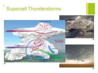
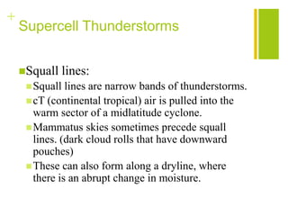
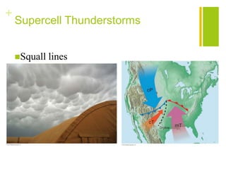
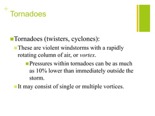
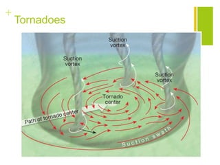
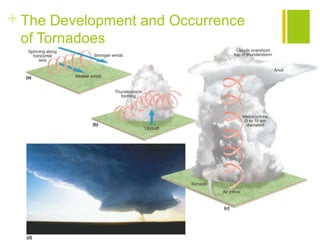
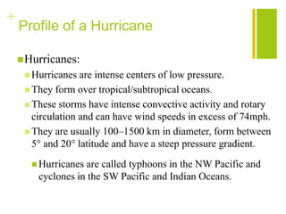
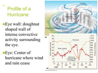
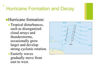
+


Thunderstorms, Tornadoes, Hurricanes
OH MY!!
           Chapters 10 and 11
+


Thunderstorms
Sections 10.1 to 10.6
+
    What’s in a Name?


    Cyclone refers to the circulation around a
     low-pressure center.
      Hurricanes
      Midlatitude   cyclones
      Tornadoes
+
    Thunderstorms

     Thunderstorms     generate lightning, thunder, winds,
     and hail.
     There   are two types of thunderstorms.
      Air-mass  thunderstorms are associated with warm,
       humid air that rises in unstable environments;
       cumulonimbus clouds, and mT (maritime tropical) air
       masses.
      Severe thunderstorms may produce high winds, hail,
       flash floods, and tornadoes.
        They are the result of uneven heating, frontal lifting,
         and diverging winds.
+
    Air-Mass Thunderstorms
    Air-mass   thunderstorms—mT air masses
+
    Air-Mass Thunderstorms

    Cumulus    stage:
      Warm,   humid air rises creating clouds that won’t
       evaporate.
      A cumulonimbus tower develops as water vapor
       moves from the surface to greater heights.
      Clouds pass freezing zone and Bergeron process
       starts.
      Rain accumulation is too great for updraft so it falls
       creating a downdraft via entrainment (influx of cool
       dry air. Remember cold air gets heavy and sinks).
+
    Air-Mass Thunderstorms


    Mature   stage:
      Thisis the most intense phase.
          This results in heavy rain and possibly
           small hail.
          Cool downdrafts exist next to updrafts.

    Dissipating   stage:
      Thisstage is dominated by downdrafts and
      entrainment causing evaporation.
+
    Air-Mass Thunderstorms
+
    Air-Mass Thunderstorms


    Occurrence:
      Mountainous  regions, such as the Rockies and
      the Appalachians, experience a greater number
      of air-mass thunderstorms.
+
    Severe Thunderstorms

    Severe    thunderstorms:
      Heavy   downpours
      Flash flooding
      Straight line wind gusts
      Hail, lightning
      Wind shear- change in wind speed or direction at
       different heights
      Can overshoot (enter stratosphere)
      Downdraft preceding (gust front)
+
    Supercell Thunderstorms
+
    Supercell Thunderstorms


     Supercells
      These storms can produce extremely dangerous
       weather.
          They consist of a single, powerful cell that can
           extend to heights of 20 km or more.
          The clouds can measure 20–50 km in diameter.

     Mesocyclone:
      Verticalwinds may cause the updraft to rotate, which
       forms a column of cyclonically rotating air.
      Tornadoes often form.
+
    Supercell Thunderstorms


    Squall     lines:
      Squall  lines are narrow bands of thunderstorms.
      cT (continental tropical) air is pulled into the
       warm sector of a midlatitude cyclone.
      Mammatus skies sometimes precede squall
       lines. (dark cloud rolls that have downward
       pouches)
      These can also form along a dryline, where
       there is an abrupt change in moisture.
+
    Supercell Thunderstorms


    Squall   lines
+
    Lightning and Thunder


     Lightning   strokes:
      The   flash (total discharge) lasts a few tenths of a
       second.
        It is what we see and it contains multiple strokes.
      The leader is the ionized air, which forms a
       conductive path.
      A step leader extends earthward in a short, nearly
       invisible burst.
      The return stroke extends upward from ground to
       cloud.
+
    Lightning and Thunder


    Thunder:
      The  air is heated quickly to as much as
       33,000°C.
      It expands explosively, which produces sound
       waves that travels at 330 mps.
            If lightning is more than 20 km away,
             thunder is not heard.
+
    Lightning and Thunder


    What   causes lightning?
+


Tornadoes
Section 10.7 to 10.10
+
    Tornadoes


    Tornadoes   (twisters, cyclones):
      These   are violent windstorms with a rapidly
       rotating column of air, or vortex.
            Pressures within tornadoes can be as much
             as 10% lower than immediately outside the
             storm.
      It may consist of single or multiple vortices.
+
    Tornadoes
+ The Development and Occurrence
 of Tornadoes
+
    The Development and Occurrence
    of Tornadoes
    Mesocyclones     form
      Winds  are stronger aloft producing rolling
       motion about a horizontal axis
      Stronger thunderstorm updrafts tilt the
       horizontal rotating air to a nearly vertical
       alignment
+
    The Development and Occurrence
    of Tornadoes

    The  mesocyclone, vertical cylinder of air, is
     established. It stretches vertically and
     narrows horizontally causing wind speeds
     to accelerate inward creating a vortex.
      FunnelCloud- vortex emerges from cloud
      Tornado- vortex touches the ground
+
    The Development and Occurrence
    of Tornadoes

    Profile   of a tornado:
      Average  diameter 150–600m
      Travels ~45 kph
      Path about 26 km long
      Most travel to the NE
      Exist between <3 min to >3 hours
      Wind speeds between <150 kph to >500 kph
        Between 90- 300mph
+
    Tornado Destruction
+


Hurricanes
Chapter 11
+
    Profile of a Hurricane

     Hurricanes:
      Hurricanes  are intense centers of low pressure.
      They form over tropical/subtropical oceans.
      These storms have intense convective activity and rotary
       circulation and can have wind speeds in excess of 74mph.
      They are usually 100–1500 km in diameter, form between
       5° and 20° latitude and have a steep pressure gradient.
       Hurricanes are called typhoons in the NW Pacific and
        cyclones in the SW Pacific and Indian Oceans.
+
    Profile of a
    Hurricane
Eye  wall: doughnut
 shaped wall of
 intense convective
 activity surrounding
 the eye.
Eye: Center of
 hurricane where wind
 and rain cease
+
    Hurricane Formation and Decay


    Hurricanes:
      Hurricanes are fueled by the latent heat of
       condensed water vapor.
      Most are formed from late summer to early fall.
      Sea-surface temperatures of 27°C or higher
       provide the necessary heat and moisture.
+
    Hurricane Formation and Decay

    Hurricane    formation:
      Tropical disturbances,
       such as disorganized
       cloud arrays and
       thunderstorms,
       occasionally grow
       larger and develop
       strong cyclonic rotation.
      Easterly waves
       gradually move from
       east to west.
+
    Hurricane Formation and Decay

 Hurricane     formation:
     As  areas within tropical disturbances get warmer, several
      factors help form hurricanes.
       Surface pressure drops creating a region of weak low
        pressure and cyclonic circulation.
       Higher pressure develops at the top of the storm causing
        an outward flow of air from the top.
     If wind speeds do not reach 63 kph, it is called a tropical
      depression.
     When winds exceed 61 kph, it becomes a tropical storm
      and is given a name.
+
    Hurricane Formation and Decay


    Hurricane   decay:
      Decay  occurs when latent heat is cut off.
      A hurricane moves over cooler water or land.
      When large scale flow aloft is unfavorable, they
       diminish in intensity.

Thunderstorms, Tornadoes, Hurricanes Oh My!

  • 1.
  • 2.
  • 3.
    + What’s in a Name? Cyclone refers to the circulation around a low-pressure center.  Hurricanes  Midlatitude cyclones  Tornadoes
  • 4.
    + Thunderstorms  Thunderstorms generate lightning, thunder, winds, and hail.  There are two types of thunderstorms.  Air-mass thunderstorms are associated with warm, humid air that rises in unstable environments; cumulonimbus clouds, and mT (maritime tropical) air masses.  Severe thunderstorms may produce high winds, hail, flash floods, and tornadoes.  They are the result of uneven heating, frontal lifting, and diverging winds.
  • 5.
    + Air-Mass Thunderstorms Air-mass thunderstorms—mT air masses
  • 6.
    + Air-Mass Thunderstorms Cumulus stage:  Warm, humid air rises creating clouds that won’t evaporate.  A cumulonimbus tower develops as water vapor moves from the surface to greater heights.  Clouds pass freezing zone and Bergeron process starts.  Rain accumulation is too great for updraft so it falls creating a downdraft via entrainment (influx of cool dry air. Remember cold air gets heavy and sinks).
  • 7.
    + Air-Mass Thunderstorms Mature stage:  Thisis the most intense phase.  This results in heavy rain and possibly small hail.  Cool downdrafts exist next to updrafts. Dissipating stage:  Thisstage is dominated by downdrafts and entrainment causing evaporation.
  • 8.
    + Air-Mass Thunderstorms
  • 9.
    + Air-Mass Thunderstorms Occurrence:  Mountainous regions, such as the Rockies and the Appalachians, experience a greater number of air-mass thunderstorms.
  • 10.
    + Severe Thunderstorms Severe thunderstorms:  Heavy downpours  Flash flooding  Straight line wind gusts  Hail, lightning  Wind shear- change in wind speed or direction at different heights  Can overshoot (enter stratosphere)  Downdraft preceding (gust front)
  • 11.
    + Supercell Thunderstorms
  • 12.
    + Supercell Thunderstorms  Supercells  These storms can produce extremely dangerous weather.  They consist of a single, powerful cell that can extend to heights of 20 km or more.  The clouds can measure 20–50 km in diameter.  Mesocyclone:  Verticalwinds may cause the updraft to rotate, which forms a column of cyclonically rotating air.  Tornadoes often form.
  • 13.
    + Supercell Thunderstorms Squall lines:  Squall lines are narrow bands of thunderstorms.  cT (continental tropical) air is pulled into the warm sector of a midlatitude cyclone.  Mammatus skies sometimes precede squall lines. (dark cloud rolls that have downward pouches)  These can also form along a dryline, where there is an abrupt change in moisture.
  • 14.
    + Supercell Thunderstorms Squall lines
  • 15.
    + Lightning and Thunder  Lightning strokes:  The flash (total discharge) lasts a few tenths of a second.  It is what we see and it contains multiple strokes.  The leader is the ionized air, which forms a conductive path.  A step leader extends earthward in a short, nearly invisible burst.  The return stroke extends upward from ground to cloud.
  • 16.
    + Lightning and Thunder Thunder:  The air is heated quickly to as much as 33,000°C.  It expands explosively, which produces sound waves that travels at 330 mps.  If lightning is more than 20 km away, thunder is not heard.
  • 17.
    + Lightning and Thunder What causes lightning?
  • 18.
  • 19.
    + Tornadoes Tornadoes (twisters, cyclones):  These are violent windstorms with a rapidly rotating column of air, or vortex.  Pressures within tornadoes can be as much as 10% lower than immediately outside the storm.  It may consist of single or multiple vortices.
  • 20.
    + Tornadoes
  • 21.
    + The Developmentand Occurrence of Tornadoes
  • 22.
    + The Development and Occurrence of Tornadoes Mesocyclones form  Winds are stronger aloft producing rolling motion about a horizontal axis  Stronger thunderstorm updrafts tilt the horizontal rotating air to a nearly vertical alignment
  • 23.
    + The Development and Occurrence of Tornadoes The mesocyclone, vertical cylinder of air, is established. It stretches vertically and narrows horizontally causing wind speeds to accelerate inward creating a vortex.  FunnelCloud- vortex emerges from cloud  Tornado- vortex touches the ground
  • 24.
    + The Development and Occurrence of Tornadoes Profile of a tornado:  Average diameter 150–600m  Travels ~45 kph  Path about 26 km long  Most travel to the NE  Exist between <3 min to >3 hours  Wind speeds between <150 kph to >500 kph  Between 90- 300mph
  • 25.
    + Tornado Destruction
  • 26.
  • 27.
    + Profile of a Hurricane  Hurricanes:  Hurricanes are intense centers of low pressure.  They form over tropical/subtropical oceans.  These storms have intense convective activity and rotary circulation and can have wind speeds in excess of 74mph.  They are usually 100–1500 km in diameter, form between 5° and 20° latitude and have a steep pressure gradient.  Hurricanes are called typhoons in the NW Pacific and cyclones in the SW Pacific and Indian Oceans.
  • 28.
    + Profile of a Hurricane Eye wall: doughnut shaped wall of intense convective activity surrounding the eye. Eye: Center of hurricane where wind and rain cease
  • 29.
    + Hurricane Formation and Decay Hurricanes:  Hurricanes are fueled by the latent heat of condensed water vapor.  Most are formed from late summer to early fall.  Sea-surface temperatures of 27°C or higher provide the necessary heat and moisture.
  • 30.
    + Hurricane Formation and Decay Hurricane formation:  Tropical disturbances, such as disorganized cloud arrays and thunderstorms, occasionally grow larger and develop strong cyclonic rotation.  Easterly waves gradually move from east to west.
  • 31.
    + Hurricane Formation and Decay  Hurricane formation:  As areas within tropical disturbances get warmer, several factors help form hurricanes.  Surface pressure drops creating a region of weak low pressure and cyclonic circulation.  Higher pressure develops at the top of the storm causing an outward flow of air from the top.  If wind speeds do not reach 63 kph, it is called a tropical depression.  When winds exceed 61 kph, it becomes a tropical storm and is given a name.
  • 32.
    + Hurricane Formation and Decay Hurricane decay:  Decay occurs when latent heat is cut off.  A hurricane moves over cooler water or land.  When large scale flow aloft is unfavorable, they diminish in intensity.