A Short History of Navigation TechnologiesMarco Lisi
A presentation on the history of navigation technologies and techniques, from Ulysses to present Global Navigation Satellite Systems, European Navigation Conference, ENC-GNSS 2009.
Training Linkedin, als bron gebruikt:
“Hoe Linkedin nu echt te gebruiken”
Jan Vermeiren – Bert Verdonck
Voor meer informatie:
http://www.how-to-really-use-linkedin.com/nl/
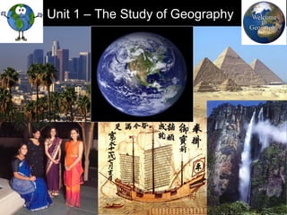
An introduction to the study of World Geography.
a) meaning of geography
b) essential elements of geography
c) branches of geography
d) themes of geography
e) graphic representation of the Earth (maps)
f) the global grid system
g) types of maps
h) map essentials
i) earth as a member of the solar system
j) the Planet Earth
k) evaluation (Quiz)
Claudius Ptolemy was an astrologer, mathematician,astronomer and geographer. He is known for his immense contribution in the field of Geography, astronomy, Mathematics as well as astronomy.
Synthetic Fiber Construction in lab .pptxPavel ( NSTU)
Synthetic fiber production is a fascinating and complex field that blends chemistry, engineering, and environmental science. By understanding these aspects, students can gain a comprehensive view of synthetic fiber production, its impact on society and the environment, and the potential for future innovations. Synthetic fibers play a crucial role in modern society, impacting various aspects of daily life, industry, and the environment. ynthetic fibers are integral to modern life, offering a range of benefits from cost-effectiveness and versatility to innovative applications and performance characteristics. While they pose environmental challenges, ongoing research and development aim to create more sustainable and eco-friendly alternatives. Understanding the importance of synthetic fibers helps in appreciating their role in the economy, industry, and daily life, while also emphasizing the need for sustainable practices and innovation.
Model Attribute Check Company Auto PropertyCeline George
In Odoo, the multi-company feature allows you to manage multiple companies within a single Odoo database instance. Each company can have its own configurations while still sharing common resources such as products, customers, and suppliers.
How to Make a Field invisible in Odoo 17Celine George
It is possible to hide or invisible some fields in odoo. Commonly using “invisible” attribute in the field definition to invisible the fields. This slide will show how to make a field invisible in odoo 17.
Honest Reviews of Tim Han LMA Course Program.pptxtimhan337
Personal development courses are widely available today, with each one promising life-changing outcomes. Tim Han’s Life Mastery Achievers (LMA) Course has drawn a lot of interest. In addition to offering my frank assessment of Success Insider’s LMA Course, this piece examines the course’s effects via a variety of Tim Han LMA course reviews and Success Insider comments.
Normal Labour/ Stages of Labour/ Mechanism of LabourWasim Ak
Normal labor is also termed spontaneous labor, defined as the natural physiological process through which the fetus, placenta, and membranes are expelled from the uterus through the birth canal at term (37 to 42 weeks
Read| The latest issue of The Challenger is here! We are thrilled to announce that our school paper has qualified for the NATIONAL SCHOOLS PRESS CONFERENCE (NSPC) 2024. Thank you for your unwavering support and trust. Dive into the stories that made us stand out!
Acetabularia Information For Class 9 .docxvaibhavrinwa19
Acetabularia acetabulum is a single-celled green alga that in its vegetative state is morphologically differentiated into a basal rhizoid and an axially elongated stalk, which bears whorls of branching hairs. The single diploid nucleus resides in the rhizoid.
2024.06.01 Introducing a competency framework for languag learning materials ...Sandy Millin
http://sandymillin.wordpress.com/iateflwebinar2024
Published classroom materials form the basis of syllabuses, drive teacher professional development, and have a potentially huge influence on learners, teachers and education systems. All teachers also create their own materials, whether a few sentences on a blackboard, a highly-structured fully-realised online course, or anything in between. Despite this, the knowledge and skills needed to create effective language learning materials are rarely part of teacher training, and are mostly learnt by trial and error.
Knowledge and skills frameworks, generally called competency frameworks, for ELT teachers, trainers and managers have existed for a few years now. However, until I created one for my MA dissertation, there wasn’t one drawing together what we need to know and do to be able to effectively produce language learning materials.
This webinar will introduce you to my framework, highlighting the key competencies I identified from my research. It will also show how anybody involved in language teaching (any language, not just English!), teacher training, managing schools or developing language learning materials can benefit from using the framework.
The French Revolution, which began in 1789, was a period of radical social and political upheaval in France. It marked the decline of absolute monarchies, the rise of secular and democratic republics, and the eventual rise of Napoleon Bonaparte. This revolutionary period is crucial in understanding the transition from feudalism to modernity in Europe.
For more information, visit-www.vavaclasses.com
21. • States What state are you from?
Canada/Spain/Argentina/South Africa – provinces
Guatemala/Columbia/Cameroon – departments
Japan/Greece – prefectures
Italy/France – regions
U.K. – counties
USA/Mexico/Brazil/Germany/Australia - states
29. • Region in a city
East Bench (Wasatch Hollows) - SLC
Sugarhouse -
SLC
30. With a Partner
• What are regional characteristics of Utah and
Cottonwood Heights/Sandy? List these
elements.
• Name another region you are familiar with
and explain what factors make it a region.
57. 57
3. Reference Maps
• Shows location of places and geographic
features
• Absolute location
Ex. Roadmap
58. 58
4. Thematic Maps
• Tells the story of the degree of an
attribute, the pattern of its distribution or
its movement.
Relative Location
59. • Map Projections – Representing Earth on a
flat sheet of paper.
1. Mercator, Robinson, Winkel and Goode
Mercator
Robinson
Winkel Goode
It is impossible to accurately portray a round
object on a flat piece of paper.
sstrength-minor distortion; weakness-flat poles
Strength-shows true
directions and shapes
Weakness-distorts size
and distance
Used most
Little distortion, most balanced
Shows true size & shape but
distance is distorted
62. • Map Elements
1. Key/legend (vocab.)
a. Explains lines, symbols and colors
2. Scale bar (vocab.)
a. Shows distance-ratio of actual ground distance to that shown on map
67. Sunrise on the Indian Ocean . . .
are you looking east or west?
Sunset on the Sahara Desert . . . are you looking
east or west?
You are looking west . . . sunrise or
sunset?
You are looking east . . . sunrise
or sunset?
68. • On a map, North is up and South is down
(generally).
Ogden is up and Provo is down.
72. Greek Mythology: Atlas
was a Titan and when the
Titans and the Olympians
went to war, the
Olympians won. His
punishment was to hold
up the heavens for
eternity. So he really
doesn’t hold up earth.
75. • Great Circle Route - Imaginary line that
follows the curve of earth.
- Who uses it and why?
76. The Great Circle Route looks longer, however, it is actually a shorter route.
Airline pilots
Benefits – reduce travel time and saves
fuel.
http://www.youtube.com/watch?
v=1XBwjQsOEeg&feature=related
82. -Geographic Information Systems
aka-GIS
• First, data is gathered from MAPS,
SATELLITE IMAGES, PRINTED TEXT
and STATISTICS
• Next, GIS converts data into digital code
and arranges it in data base.
• Last, Cartographers program the GIS to
process the data and produce maps.
p. 15 in text
84. • Earth
BTW
- Earth is moving at 67,000 mph
around the sun (Nicolaus
Copernicus 1473 - 1543 AD).
- Earth is spinning (rotating) 1,037
mph at the equator & 0 mph at the
poles.
- Thank you gravity!!!! (natural force
that pulls everything down to the
ground) and Sir Isaac Newton
1642 – 1727 AD.
85. A sphere is a round geometrical
object in 3-dimentional space.
Please write down
When was Earth discovered
to be round (sphere)?
86.
87.
88.
89. • The ancient Greeks knew that Earth was round
(sphere) about 2,000 years before Columbus.
- Aristotle 384 - 322 BC
Parthenon in Athens, Greece
- Pythagoras c. 570 - c. 495 BC
Pythagoras – “All celestial bodies are spherical”
Aristotle – “Only a sphere can cast a shadow in
every direction.” (referencing an eclipse)
90. • Father of Geography
- Eratosthenes (Greek c. 276 – c. 195 BC)
91. Eratosthenes was the first person to calculate (with incredible accuracy) the circumference of earth,
at 25,000 miles, by measuring angles of shadows. Actually, earth is 24,901 miles at the equator &
24,859 through the poles (centrifugal force).
Eratosthenes
was only off by
99 miles
(equator).
obelisk
Alexandria and
Syene are both in
Egypt.
93. A Greek named Posidonius,
who lived 100 years after
Eratosthenes, measured earth
at 18,000 miles. Columbus, in
1492 AD, used Posidonius
instead of Eratosthenes
measurement (Columbus did
know that Earth was round
before his famous voyage). As
a result, he thought that he
would get to “India” much
faster than he did.
94. • Location
1. Absolute Location - exact location of a
place on Earth (address).
a. Latitude and Longitude (vocab.) - Imaginary lines marking
positions on earth.
Eratosthenes was, also,
the first to use the word
“geography” and he
invented the concept of
latitude and longitude. At
an old age, Eratosthenes
became blind and he died
of self-induced starvation.
Eratosthenes
some dude
dog?
95. The ancient Babylonians,
actually, assigned numbers
to a circle. Ptolemy,
however, incorporated
them into the longitude and
latitude coordinates.
96. Ptolemy (Greek &
Roman citizen who
lived in Egypt c. 90 AD
– c. 168 AD) – he
assigned coordinates
to all of the places and
geographic features he
knew . . . in a grid.
97. 1. Latitude (flatitude)
a. Equator - 0 degrees latitude.
b. Tropic of Cancer (North) and
Capricorn (South) - 23.5 degrees
98. The Seasons:
Revolution of Earth
around the Sun and the
tilt of Earth’s axis
(revolution and rotation).
http://www.youtube.com/watch?
v=NydSuHoQZqk&feature=related&safety_mode=tru
e&persist_safety_mode=1&safe=active
Eratosthenes
was,also, the first to
accurately calculate
the tilt of Earth’s axis
at 23.5 degrees.
Where is the
Arctic Circle?
100. Equator 0
Tropic of Capricorn 23.5 S
Tropic of Cancer 23.5 N
Arctic Circle 66.5 N
Antarctic Circle 66.5 S
Hemispheres?
How to remember:
Latitude = Flatitude
101. 2. Longitude
1. Prime Meridian - 0 degrees longitude.
a. Old Royal Observatory in
Greenwich, England (U.K.)
111. 2. Relative Location
a. Where a place is located in relation to
other places.
1. Example: NYC is east of Chicago,
Illinois.
112. • Time on Earth
1. Standard Time (since 1884)
a. Based on the Prime Meridian.
1. Greenwich Mean Time (GMT)
113. • Time Zone (vocab.) – one of the 24 regions or divisions of Earth’s surface
used to determine local time in a given locality. Why do we have them?
114. • Because the sun’s rays are hitting Earth at
different times and in different places.
How many time
zones are there
worldwide?
115. 1. 24 time zones worldwide
a. One time zone = about 15 degrees
longitude.
1. U.S. Time Zones
a. East to west - Eastern, Central,
Mountain, Pacific, Alaska and Hawaii
China – one time zone
Russia – eleven time zones
116. The difference between each line of longitude is15 degrees. There are 24
increments of 15 degrees of longitude. How many hours in a day?
122. Lake Mead
Lake Mead is right on the border between Arizona and Nevada. The two states are in
different time zones (at least for part of the year).
124. • Daylight Savings Time
- “Spring Forward” and “Fall Back”
- There are two states with no daylight savings . . . What are they?
- November 3rd
2013
- March 9th
2014
125. - States with no daylight savings
- Hawaii and Arizona
Hawaii
Arizona
126. • International Dateline
1. Marks the place where each day officially begins.
2. The west side of the line is always one day ahead
of the east side.
http://www.youtube.com/watch?
v=Ra4nHwdTQ4Y&safety_mode=true&persist_safety_mode=1
http://www.youtube.com/watch?
v=qlmpIuaOBNY&NR=1&safety_mode=true&persist_safety_mo
http://www.youtube.com/watch?
v=1jbZoTlnmEA&feature=related&safety_mode=true&persist_safety_
Add Subtract