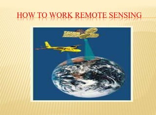
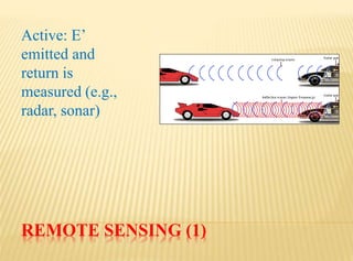
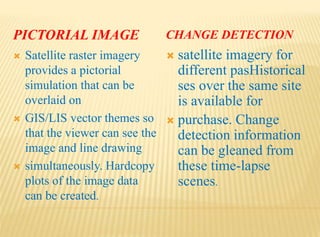
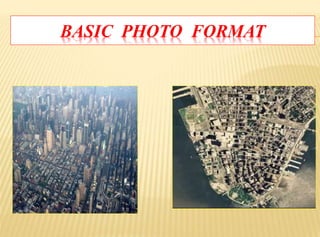
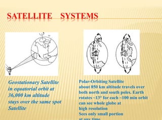
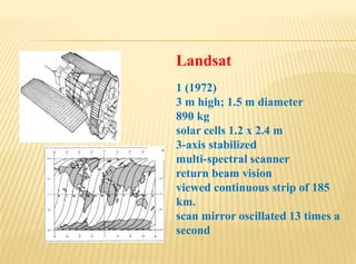
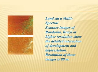
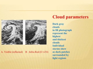
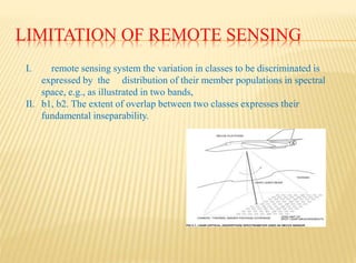
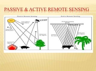
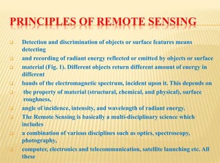
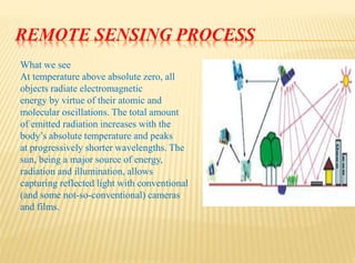
REMOTE SENSING
SHREE SWAMI ATMANAND SARASWATI
INSTITUTE OF TECHNOLOGY
PREPARED BY:
Prof. Karm Balar
REMOTE SENSING(GIS)
 Definition of Remote sensing
 Advantages Of Remote sensing
 Elements of Remote sensing
 Limitation of Remote sensing
 Principal Of Remote Sensing
DEFINITION OF REMOTE SENSING
 Remote sensing is the science of gathering
information from a location that is distant from the
data source. Image analysis is the science of
interpreting specific criteria from a remotely sensed
image.
 assistance of computer enhancement, extract
information from an image, whetherit is furnished in
the form of an aerial photograph, a multispectral
satellite scene, a,
 radar image, a base of LIDAR data, or a thermal
scan.
HOW TO WORK REMOTE SENSING
ADVANTAGES OF SATELLITE SCENES
Presuming that the inherent
accuracy of satellite data conforms
to the mapping
specification demands, satellite data
can be a valuable tool in many
ways.
REMOTE SENSING (1)
Active: E’
emitted and
return is
measured (e.g.,
radar, sonar)
PICTORIAL IMAGE CHANGE DETECTION
 Satellite raster imagery
provides a pictorial
simulation that can be
overlaid on
 GIS/LIS vector themes so
that the viewer can see the
image and line drawing
 simultaneously. Hardcopy
plots of the image data
can be created.
 satellite imagery for
different pasHistorical
ses over the same site
is available for
 purchase. Change
detection information
can be gleaned from
these time-lapse
scenes.
BASIC PHOTO FORMAT
SATELLITE SYSTEMS
Geostationary Satellite
in equatorial orbit at
36,000 km altitude
stays over the same spot
Satellite
Polar-Orbiting Satellite
about 850 km altitude travels over
both north and south poles. Earth
rotates ~13° for each ~100 min orbit
can see whole globe at
high resolution
Sees only small portion
Landsat
1 (1972)
3 m high; 1.5 m diameter
890 kg
solar cells 1.2 x 2.4 m
3-axis stabilized
multi-spectral scanner
return beam vision
viewed continuous strip of 185
km.
scan mirror oscillated 13 times a
second
Land sat a Multi-
Spectral
Scanner images of
Rondonia, Brazil at
higher resolution show
the detailed interaction
of development and
deforestation.
Resolution of these
images is 80 m.
Cloud parameters
Dark gray
clouds
in IR photograph
represent the
highest
and thickest
clouds
Individual
storms show
as dark patches
surrounded by
light regions
A. Visible (reflected) B . Infra-Red (E=sT4)
LIMITATION OF REMOTE SENSING
I. remote sensing system the variation in classes to be discriminated is
expressed by the distribution of their member populations in spectral
space, e.g., as illustrated in two bands,
II. b1, b2. The extent of overlap between two classes expresses their
fundamental inseparability.
 Variation in different components of the system, such as
benthic class
spectral variation, variance in water clarity, or sensor noise,
contributes to variation in the
recorded signal.sensor limited objectives are those for which
change in sensor
PASSIVE & ACTIVE REMOTE SENSING
PRINCIPLES OF REMOTE SENSING
 Detection and discrimination of objects or surface features means
detecting
 and recording of radiant energy reflected or emitted by objects or surface
 material (Fig. 1). Different objects return different amount of energy in
different
 bands of the electromagnetic spectrum, incident upon it. This depends on
 the property of material (structural, chemical, and physical), surface
roughness,
 angle of incidence, intensity, and wavelength of radiant energy.
 The Remote Sensing is basically a multi-disciplinary science which
includes
 a combination of various disciplines such as optics, spectroscopy,
photography,
 computer, electronics and telecommunication, satellite launching etc. All
these
STAGES IN REMOTE SENSING
 • Emission of electromagnetic radiation, or EMR
(sun/self- emission)
 • Transmission of energy from the source to the surface of
the earth, as well
 as absorption and scattering
 • Interaction of EMR with the earth’s surface: reflection
and emission
 • Transmission of energy from the surface to the remote
sensor
 • Sensor data output
REMOTE SENSING PROCESS
What we see
At temperature above absolute zero, all
objects radiate electromagnetic
energy by virtue of their atomic and
molecular oscillations. The total amount
of emitted radiation increases with the
body’s absolute temperature and peaks
at progressively shorter wavelengths. The
sun, being a major source of energy,
radiation and illumination, allows
capturing reflected light with conventional
(and some not-so-conventional) cameras
and films.
MODERN REMOTE SENSING TECHNOLOGY
VERSUS CONVENTIONALAERIAL
The use of different and extended portions of the
electromagnetic
spectrum, development in sensor technology,
different platforms for remote
sensing (spacecraft, in addition to aircraft),
emphasize on the use of spectral
information as compared to spatial information,
advancement in image
processing and enhancement techniques, and
automated image analysis in
addition to manual interpretation are points for
THANK YOU

Remote sensing

  • 1.
    REMOTE SENSING SHREE SWAMIATMANAND SARASWATI INSTITUTE OF TECHNOLOGY
  • 2.
  • 3.
    REMOTE SENSING(GIS)  Definitionof Remote sensing  Advantages Of Remote sensing  Elements of Remote sensing  Limitation of Remote sensing  Principal Of Remote Sensing
  • 4.
    DEFINITION OF REMOTESENSING  Remote sensing is the science of gathering information from a location that is distant from the data source. Image analysis is the science of interpreting specific criteria from a remotely sensed image.  assistance of computer enhancement, extract information from an image, whetherit is furnished in the form of an aerial photograph, a multispectral satellite scene, a,  radar image, a base of LIDAR data, or a thermal scan.
  • 5.
    HOW TO WORKREMOTE SENSING
  • 6.
    ADVANTAGES OF SATELLITESCENES Presuming that the inherent accuracy of satellite data conforms to the mapping specification demands, satellite data can be a valuable tool in many ways.
  • 7.
    REMOTE SENSING (1) Active:E’ emitted and return is measured (e.g., radar, sonar)
  • 8.
    PICTORIAL IMAGE CHANGEDETECTION  Satellite raster imagery provides a pictorial simulation that can be overlaid on  GIS/LIS vector themes so that the viewer can see the image and line drawing  simultaneously. Hardcopy plots of the image data can be created.  satellite imagery for different pasHistorical ses over the same site is available for  purchase. Change detection information can be gleaned from these time-lapse scenes.
  • 9.
  • 10.
    SATELLITE SYSTEMS Geostationary Satellite inequatorial orbit at 36,000 km altitude stays over the same spot Satellite Polar-Orbiting Satellite about 850 km altitude travels over both north and south poles. Earth rotates ~13° for each ~100 min orbit can see whole globe at high resolution Sees only small portion
  • 11.
    Landsat 1 (1972) 3 mhigh; 1.5 m diameter 890 kg solar cells 1.2 x 2.4 m 3-axis stabilized multi-spectral scanner return beam vision viewed continuous strip of 185 km. scan mirror oscillated 13 times a second
  • 12.
    Land sat aMulti- Spectral Scanner images of Rondonia, Brazil at higher resolution show the detailed interaction of development and deforestation. Resolution of these images is 80 m.
  • 13.
    Cloud parameters Dark gray clouds inIR photograph represent the highest and thickest clouds Individual storms show as dark patches surrounded by light regions A. Visible (reflected) B . Infra-Red (E=sT4)
  • 14.
    LIMITATION OF REMOTESENSING I. remote sensing system the variation in classes to be discriminated is expressed by the distribution of their member populations in spectral space, e.g., as illustrated in two bands, II. b1, b2. The extent of overlap between two classes expresses their fundamental inseparability.
  • 16.
     Variation indifferent components of the system, such as benthic class spectral variation, variance in water clarity, or sensor noise, contributes to variation in the recorded signal.sensor limited objectives are those for which change in sensor
  • 17.
    PASSIVE & ACTIVEREMOTE SENSING
  • 18.
    PRINCIPLES OF REMOTESENSING  Detection and discrimination of objects or surface features means detecting  and recording of radiant energy reflected or emitted by objects or surface  material (Fig. 1). Different objects return different amount of energy in different  bands of the electromagnetic spectrum, incident upon it. This depends on  the property of material (structural, chemical, and physical), surface roughness,  angle of incidence, intensity, and wavelength of radiant energy.  The Remote Sensing is basically a multi-disciplinary science which includes  a combination of various disciplines such as optics, spectroscopy, photography,  computer, electronics and telecommunication, satellite launching etc. All these
  • 19.
    STAGES IN REMOTESENSING  • Emission of electromagnetic radiation, or EMR (sun/self- emission)  • Transmission of energy from the source to the surface of the earth, as well  as absorption and scattering  • Interaction of EMR with the earth’s surface: reflection and emission  • Transmission of energy from the surface to the remote sensor  • Sensor data output
  • 20.
    REMOTE SENSING PROCESS Whatwe see At temperature above absolute zero, all objects radiate electromagnetic energy by virtue of their atomic and molecular oscillations. The total amount of emitted radiation increases with the body’s absolute temperature and peaks at progressively shorter wavelengths. The sun, being a major source of energy, radiation and illumination, allows capturing reflected light with conventional (and some not-so-conventional) cameras and films.
  • 21.
    MODERN REMOTE SENSINGTECHNOLOGY VERSUS CONVENTIONALAERIAL The use of different and extended portions of the electromagnetic spectrum, development in sensor technology, different platforms for remote sensing (spacecraft, in addition to aircraft), emphasize on the use of spectral information as compared to spatial information, advancement in image processing and enhancement techniques, and automated image analysis in addition to manual interpretation are points for
  • 22.