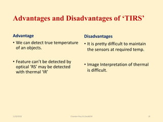
This document provides an overview of thermal remote sensing. It begins with an introduction to remote sensing and defines thermal remote sensing as measuring electromagnetic radiation in the thermal infrared region. It describes the atmospheric windows and fundamental radiation laws governing thermal remote sensing. Applications discussed include surface temperature detection, fire detection, and volcano monitoring. The document concludes with the advantages of being able to detect true temperatures and limitations such as difficulty maintaining sensor temperatures.
The document provides an overview of thermal remote sensing. It discusses key concepts like the thermal infrared spectrum, atmospheric windows and absorption bands, fundamental radiation laws, thermal data acquisition using sensors, and applications in mapping forest fires, urban heat islands, volcanoes, and military purposes. Thermal remote sensing allows measuring the true temperature of objects and detecting features not visible in optical remote sensing. It has advantages like temperature measurement but maintaining sensors at low temperatures can be challenging.
Aerial photography involves taking photographs from aircraft and is used for mapping and studying the Earth's surface. It has various uses like making pictorial representations, preparing base maps, photo interpretation, and expediting natural resource surveys. Factors like atmospheric conditions, aircraft, camera, and film processing influence aerial photographs. There are different types of aerial photographs based on the camera axis position and various stages involved in planning and executing aerial photography flights.
Types of Platforms
1. Airbrone Platforms
2. Spacebrone Platforms
Platforms are Vital Role in remote sensing data acquisition
Necessary to correct the position the remote sensors that collect data from the objects of interest
This document discusses remote sensing and geographical information systems in civil engineering. It covers various topics related to remote sensing sensors including optical sensors, thermal scanners, multispectral sensors, passive and active sensors, scanning and non-scanning sensors, imaging and non-imaging sensors, and the different types of resolutions including spatial, spectral, radiometric, and temporal resolution. It provides examples and illustrations of these concepts.
The document discusses different types of scanning systems used to collect remote sensing data. It describes whiskbroom scanners that use rotating mirrors to scan perpendicular to the flight path, building up images line-by-line. Pushbroom scanners use linear detector arrays that collect entire lines of pixels simultaneously as the sensor moves. Circular scanners employ rotating mirrors to scan in circular patterns, while side-scanning uses active radar to illuminate terrain to one side of the flight path. The characteristics of Landsat, SPOT, and sensor technologies are also overviewed.
This document provides an overview of remote sensing concepts. It defines remote sensing as acquiring information about an object without physical contact. Remote sensing data is collected from platforms like satellites and aircraft and analyzed. The document outlines the electromagnetic spectrum, how energy interacts with the atmosphere and objects, different sensor and image types, and resolutions. It also defines key terms like digital image, satellite imagery, spectral signature, and discusses different platform and sensor types used in remote sensing.
The document provides an overview of remote sensing techniques used in civil engineering projects. It discusses (1) the electromagnetic spectrum used for remote sensing, including microwave and radar bands; (2) active and passive microwave sensing methods such as SAR; and (3) applications like flood mapping, soil moisture monitoring, and landslide prediction. The document is a useful primer on how remote sensing and GIS technologies can support infrastructure and environmental monitoring.
Basic Concepts, Explanation, and Application. Fundamental Remote Sensing; Advantage/ disadvantages, Imaging/non Imaging sensors, RAR and SAR, SAR Geometry, Resolutions in the microwave, Geometric Distortions in SAR, Polarization in SAR, Target Interaction, SAR Interferometry
This document discusses remote sensing platforms and sensors. It describes the different types of orbits used by remote sensing satellites, including low Earth orbit, sun synchronous orbit, and geostationary orbit. It also outlines the various platforms that can be used, such as ground-based, airborne, and space-borne. Finally, it examines the characteristics of remote sensing sensors, including spatial, spectral, radiometric, and temporal resolution.
This document provides an overview of remote sensing. It defines remote sensing as acquiring information about the Earth's surface without physical contact using sensors. It discusses various remote sensing platforms, data sources, processes, applications, organizations, and history. The key applications of remote sensing mentioned are land use mapping, agriculture, forestry, water management, and environmental monitoring. Satellite images are provided as examples to illustrate monitoring of deforestation and flood damage assessment.
This document defines and describes Digital Elevation Models (DEMs). It discusses that DEMs are 3D representations of land surface elevation from various data sources. There are two main types of DEMs - raster and vector (TIN). Data can be captured through remote sensing, photogrammetry, or land surveys. Free global DEMs are available from sources like SRTM, ASTER, and ALOS. DEMs have many applications including terrain analysis, hydrology, mapping, and more.
Thermal infrared remote sensing involves observing electromagnetic radiation emitted from objects in the thermal infrared wavelength range of 3-14 micrometers. In this range, sensors can detect the thermal radiative properties of ground materials. Thermal infrared imagery captures relative differences in surface temperature or radiance. Interpreting thermal images requires understanding factors like the time of day the image was taken, whether it is a positive or negative image, and how emissivity and other surface characteristics impact observed radiation and temperature values.
The document discusses different types of remote sensing scanners. It describes multispectral scanners, thematic mappers, thermal scanners, and hyperspectral scanners. Multispectral scanners collect data in multiple wavelength bands using either across-track or along-track scanning. Thematic mappers were developed to improve upon multispectral scanners. Thermal scanners sense the thermal infrared wavelength range. Hyperspectral scanners record over 100 contiguous spectral bands to generate a continuous reflectance spectrum for each pixel.
Microwave remote sensing uses both passive and active sensors operating within the wavelength range of 1mm to 1m. Passive sensors such as microwave radiometers record naturally emitted energy, while active sensors like synthetic aperture radar (SAR) generate their own electromagnetic signals. SAR is an example of side-looking radar that uses signal processing to synthesize a very long antenna and improve azimuth resolution. Radar imagery exhibits characteristics like penetration of vegetation and clouds, day/night imaging, and sensitivity to surface properties. However, it also shows distortions from terrain relief and speckle noise from signal interference.
Glaciers are large, dense accumulations of snow and ice that form on land where snowfall exceeds melting over many years. They are distinct from sea ice and lake ice. Glaciers cover 10% of the world's land area and store the largest reservoir of fresh water on Earth. The scientific study of glaciers is called glaciology and involves understanding their relationships with climate, sea levels, and impacts on humans and the environment. Remote sensing techniques such as aerial photography, satellite imagery, and radar are powerful tools for monitoring and mapping glaciers, which are often located in remote areas. Different sensors can detect glacial features, measure glacier flow velocities, and help determine mass balances and snowmelt runoff.
Geographic information systems (GIS) are organized collections of computer hardware, software, and geographic data used to capture, store, update, manipulate, analyze, and display geographically referenced information. GIS provides spatial data depicted as points, lines, or polygons with attributes stored in tables, and can take data from various sources and integrate them into multiple layers for analysis. Common applications of GIS include agriculture, natural resource management, disaster management, and urban planning.
This document provides an overview of ground truthing for remote sensing. It defines ground truth as observations or measurements made near the Earth's surface to support air or space-based remote sensing. Ground truth is collected using tools like GPS, radiometers, cameras, and topographic maps. It involves field observations, spectral measurements, location coordinates and sample collection to validate remote sensing data and reduce classification errors. The process of ground truthing helps verify pixel contents on satellite images and assess classification accuracy.
Certain regions of the EM spectrum cannot be used for remote sensing due to atmospheric absorption. The regions that are not absorbed are called "atmospheric windows" which allow transmission of energy. The main atmospheric windows are in the visible and radio frequency regions, while other regions like X-Rays and UV are strongly absorbed. Ideal remote sensing systems do not exist in reality due to factors like variable energy sources, atmospheric effects, complex surface-energy interactions, limitations of sensors and data handling, and few users.
Landsat was a joint NASA/USGS satellite program designed to systematically acquire global land surface images. Landsat 1 was launched in 1972 as the first satellite dedicated to observing Earth's land areas. Subsequent Landsat satellites carried improved sensors with higher spatial, spectral, and radiometric resolutions. Landsat provides repetitive coverage of the entire global land mass with images useful for mapping and monitoring land use change over time.
Scanners, image resolution, orbit in remote sensing, pk maniP.K. Mani
This document provides information about different types of satellite orbits and sensors. It discusses polar orbits, geostationary orbits, and examples of weather satellites like METEOSAT, NOAA, and GOES that use these orbit types. It also describes imaging sensors on these satellites and their specifications. Sensors on other platforms like Landsat, SPOT, ERS, and Radarsat are outlined along with their characteristics and applications. Scanning techniques for collecting multispectral data like across-track and along-track scanning are defined.
Perhaps the most important component of a GIS is in the part of data used in GIS. The data for GIS can be derived from various sources. A wide variety of data sources exist for both spatial and attribute data.
Analysis of remote sensing imagery involves identifying targets through their tone, shape, size, pattern, texture, and relationships to other objects. Targets may be environmental or artificial features appearing as points, lines, or areas. Interpretation relies on how radiation is reflected or emitted from targets and recorded by sensors to form images. The key to interpretation is recognizing targets based on these visual elements.
Iirs lecure notes for Remote sensing –An Overview of Decision MakerTushar Dholakia
The document provides an overview of remote sensing including:
1) Defining remote sensing as acquiring information about Earth's surface without physical contact using sensors to detect reflected or emitted energy.
2) Describing the basic components and processes of remote sensing including emission, transmission, interaction with the surface, and sensor data acquisition.
3) Detailing the interaction of electromagnetic radiation with Earth's surfaces and the information that can be derived from changes in magnitude, direction, wavelength and other properties.
4) Explaining the different types of remote sensing platforms, sensors, resolutions and wavelengths used in remote sensing from visible light to microwaves.
5) Providing an overview of Indian remote sensing satellites
Remote sensing - Sensors, Platforms and Satellite orbitsAjay Singh Lodhi
Remote sensing uses sensors on various platforms to detect electromagnetic radiation from the Earth. Sensors can be passive, detecting natural radiation, or active, emitting their own radiation. Platforms include ground-based, airborne, and space-based options at increasing heights. Space-based platforms include low Earth orbit satellites in polar or sun synchronous orbits for frequent coverage, and geostationary satellites for continuous coverage of fixed regions. Different sensors have varying spatial, spectral, radiometric, and temporal resolutions to detect features on Earth.
This document discusses stereoscopic vision and its use in aerial photo interpretation. Stereoscopic vision involves using binocular vision to view overlapping photos from two camera positions to perceive 3D depth. Various stereoscopes can be used, like lens stereoscopes suitable for field use. Key measurements for determining object heights from stereo pairs include the average photo base length and differential parallax. Precise stereoplotters and software can digitally recreate stereo models for mapping. Orthophotos rectify photos to show objects in true planimetric positions.
The document discusses the four types of image resolution: spatial, spectral, radiometric, and temporal resolution. Spatial resolution refers to the ability of a sensor to identify the smallest details visible in an image. Spectral resolution is the sensor's ability to distinguish between narrow wavelength bands, while radiometric resolution refers to its ability to detect small differences in energy levels. Temporal resolution describes how frequently data is captured for a given location. Higher resolution in all four types provides more detailed, clear images for analysis.
Multispectral remote sensing involves collecting reflected, emitted, and backscattered energy from objects in multiple bands of the electromagnetic spectrum simultaneously. There are three main types of multispectral sensor systems: line detectors that detect one object at a time; whiskbroom/cross-track sensors that use a rotating mirror to scan the surface; and pushbroom/along-track sensors that have no moving parts and sense energy directly using arrays of detectors. Multispectral remote sensing has applications in military intelligence gathering, medical imaging, land assessment, and studying seasonal variations.
Thermal remote sensing measures electromagnetic radiation emitted from the surface of objects to estimate their temperature. It detects thermal properties rather than reflected solar radiation. Measurements provide the radiant temperature, which depends on the kinetic temperature and emissivity. Thermal remote sensing is used for applications like environmental monitoring, geology, agriculture, and urban planning by analyzing surface temperatures from satellites or aircraft.
This document reviews pyranometers, which are instruments used to measure solar radiation. It discusses two main types of
pyranometers - thermopile pyranometers and photodiode pyranometers. Thermopile pyranometers measure temperature differences
between a black surface exposed to sunlight and a reference white surface, while photodiode pyranometers directly convert solar
radiation to an electrical current using a photodiode. The document also summarizes previous work on developing low-cost
pyranometers using locally available materials like photodiodes, concluding that photodiode pyranometers have advantages over
thermopile pyranometers like lower cost and requiring less maintenance.
This document provides information about infrared detection technology, including the principles of blackbody radiation, emissivity, and Planck's radiation law. It discusses different types of infrared detectors such as photon detectors, which require cooling, and thermal detectors, whose output depends on temperature changes from absorbed radiation. Examples of applications for infrared detectors include medical diagnosis, security/surveillance, and condition monitoring. The document also summarizes infrared imaging and different detector technologies.
This document summarizes principles and applications of infrared photodetectors. It discusses the history and development of IR detectors from the 1800s to present. There are two main types of IR detectors - photon detectors and thermal detectors. Photon detectors respond to infrared photons and require cryogenic cooling, while thermal detectors respond to changes in temperature. The document focuses on mercury cadmium telluride (HgCdTe) short-wave infrared sensors, which can be tuned to detect different infrared wavelengths depending on their composition. HgCdTe detectors are widely used due to their high electron mobility and ability to absorb infrared radiation.
A systematic procedure for the use of state feedback and output feedback to control
Induction motor is studied. The impact of which is to explore the advantages of feedback control
assuming that all the state variables are measurable. Feedback control is capable of being used for
asymptotic stability of the desired operating condition, for any load torque and for any initial
condition. A suitable model enables motor faults to be simulated and the change in corresponding
parameters to be predicted without physical experimentation. This project presents a
mathematical foundation and theoretical analysis of modeling and applications of induction
machines. A three-phase induction motor is simulated with fundamental equations. The
simulations results are presented for understanding purpose.
This paper reviews in brief about solar radiation and pyranometer to measure the same.In order
to assess the availability of solar energy arriving on the earth, measurement of solar radiation at some locations
is essential. From measurements, empirical models are developed to predict the availability of solar energy at
other locations.[8] The common, commercial pyranometer design uses a thermopile, setting up a voltage
proportional to the radiation based on temperature readings. This necessitates temperature
compensation.Using photovoltaic silicon cells, instead of thermocouples, the global irradiance as well as its
direct and diffuse components to great accuracy can be measured. Pyranometer is basically just comprised of
two solar cells and a voltage amplifier.
This document discusses infrared radiation and infrared temperature measurement. It begins with an introduction to infrared radiation and its uses. It then covers the history of infrared detectors and their development. It describes the measurement principle for infrared temperature measurement, discussing Wien's displacement law, Stefan-Boltzmann law, and Kirchoff's law. It outlines different types of infrared sensors and concludes that the infrared industry is transitioning to enable mass production and detection of cold targets at long ranges.
Infrared radiation is electromagnetic radiation with wavelengths longer than those of visible light, ranging from 700 nanometers to 1 millimeter. It is emitted or absorbed by molecules as they change their rotational-vibrational movements. Infrared radiation is used for a variety of applications including night vision, thermography, spectroscopy, telecommunications, and heating.
IRJET- Infrared Thermography and its Application in Building ConstructionIRJET Journal
This document discusses the use of infrared thermography in building construction. Infrared thermography is a non-destructive testing method that uses infrared cameras to detect temperature variations on surfaces. This allows it to identify defects in concrete like voids, cracks, or moisture. The document provides examples of how infrared thermography has been used to detect moisture penetration in structures, locate plumbing pipes, and assess the quality of fresh concrete. It also discusses how infrared cameras can monitor the curing of concrete and identify failure points in reinforced steel bars during tensile testing.
Smart materials are designed materials that can significantly change one or more properties, such as shape, color, or conductivity, in response to external stimuli like temperature, stress, moisture, or electric/magnetic fields. Some examples include piezoelectric materials that generate voltage or change shape in response to electric fields, shape memory alloys that can return to their original shape after deformation when heated, and halochromic materials that change color with pH changes. Smart materials have properties like immediacy, transiency, self-actuation, selectivity, and directness in their responses to environmental changes.
Near-infrared (NIR) spectroscopy was discovered in the 18th century by William Herschel. NIR spectroscopy works by measuring overtones and combinations of vibrations from bonds like C-H, O-H, and N-H. It can be used to identify raw materials and monitor pharmaceutical manufacturing processes. Common instrumentation includes light sources, monochromators, sample holders, and detectors like PbS, PbSe, and Si. NIR spectroscopy has applications in pharmaceutical quality control, agricultural analysis, and food and material testing.
Thermal detectors contain a small active element that absorbs radiation and experiences a temperature change. The temperature change is inversely proportional to the exposed surface area of the element. There are several types of thermal detectors including thermocouples, thermistors, and pneumatic devices like the Golay cell. Thermocouples use two dissimilar metals where radiation heats the junction and creates a potential difference. Thermistors are made of materials with resistance highly dependent on temperature. Pyroelectric detectors contain non-centrosymmetric crystals that generate an electric field in response to temperature change rate. The Golay cell consists of a gas-filled cylinder with a flexible diaphragm that deforms in response to pressure changes
This Application Note describes the technology and applications of infrared heating. The basic principles behind the technology and its important characteristics, such as the effect of emissivity and shape coefficient on the rate of transfer of thermal energy, are described.
Infrared heating is characterized by high energy densities, rapid heating, and relative ease of installation. All these advantages offer the possibility of higher production speeds, more compact installations, and lower investment costs. Thus, in many industrial production processes, infrared heating offers advantages with respect to conventional heating techniques such as convection or hot air ovens.
Thermal Infrared Primer v7 Final for approvalSteve Simser
This document provides information about Alberta's use of thermal infrared technology to detect wildfires. It discusses the basics of infrared radiation and factors that can impact infrared scanning missions. Alberta uses a four-tiered approach to infrared scanning including handheld, low altitude, high altitude, and satellite. The document provides guidelines for requesting infrared scans and examples of forms used. It aims to educate about best practices to ensure successful infrared scanning.
This document discusses pyrometers, which are devices used to measure temperature without physical contact by measuring the electromagnetic radiation emitted by hot bodies. There are two main types of pyrometers: radiation pyrometers and optical pyrometers. Radiation pyrometers use an optical system including a lens, mirror, and adjustable eyepiece to collect the heat energy emitted by a hot body and focus it onto a detector, which converts it into an electrical signal and temperature display. Radiation pyrometers are able to measure high temperatures without contact and provide a fast response.
Solar resource measurements and sattelite dataSolarReference
To access explanatory notes and download link, head to -
http://solarreference.com/all-you-need-to-know-about-solar-resource-measurement/
This presentation can also be downloaded for SFERA website (SFERA Summer School 2013). Amazing, concise, to the point document. For more quality resources, visit
http://solarreference.com
Radiation pyrometers measure temperature without physical contact by measuring the electromagnetic radiation emitted by hot bodies. There are two main types of pyrometers - radiation pyrometers and optical pyrometers. Radiation pyrometers have an optical system including a lens, mirror, and adjustable eyepiece that collects the heat energy from a hot body and focuses it onto a detector, which converts it into an electrical signal and temperature display. They are able to measure high temperatures without contact and have fast response speeds.
OBT751 Analytical methods Instrumentation materialsMercy Joseph
Instrumental methods of analysis have several advantages over chemical methods, including requiring only small sample sizes, being faster, and being able to analyze complex mixtures. The basic functions of instrumental analysis are signal generation, transduction, amplification, and presentation. Instrumental techniques are divided into spectroscopy, electrochemistry, and chromatography. Noise in instrumental analysis can come from chemical, instrumental, thermal, shot, flicker, or environmental sources. Hardware techniques can help reduce environmental, flicker, and transducer noise through methods like filters, choppers, shields, modulators, and synchronous detection.
Similar to Thermal remote sensing and its applications (20)
This presentation was provided by Racquel Jemison, Ph.D., Christina MacLaughlin, Ph.D., and Paulomi Majumder. Ph.D., all of the American Chemical Society, for the second session of NISO's 2024 Training Series "DEIA in the Scholarly Landscape." Session Two: 'Expanding Pathways to Publishing Careers,' was held June 13, 2024.
Leveraging Generative AI to Drive Nonprofit InnovationTechSoup
In this webinar, participants learned how to utilize Generative AI to streamline operations and elevate member engagement. Amazon Web Service experts provided a customer specific use cases and dived into low/no-code tools that are quick and easy to deploy through Amazon Web Service (AWS.)
This document provides an overview of wound healing, its functions, stages, mechanisms, factors affecting it, and complications.
A wound is a break in the integrity of the skin or tissues, which may be associated with disruption of the structure and function.
Healing is the body’s response to injury in an attempt to restore normal structure and functions.
Healing can occur in two ways: Regeneration and Repair
There are 4 phases of wound healing: hemostasis, inflammation, proliferation, and remodeling. This document also describes the mechanism of wound healing. Factors that affect healing include infection, uncontrolled diabetes, poor nutrition, age, anemia, the presence of foreign bodies, etc.
Complications of wound healing like infection, hyperpigmentation of scar, contractures, and keloid formation.
A Visual Guide to 1 Samuel | A Tale of Two HeartsSteve Thomason
These slides walk through the story of 1 Samuel. Samuel is the last judge of Israel. The people reject God and want a king. Saul is anointed as the first king, but he is not a good king. David, the shepherd boy is anointed and Saul is envious of him. David shows honor while Saul continues to self destruct.
Level 3 NCEA - NZ: A Nation In the Making 1872 - 1900 SML.pptHenry Hollis
The History of NZ 1870-1900.
Making of a Nation.
From the NZ Wars to Liberals,
Richard Seddon, George Grey,
Social Laboratory, New Zealand,
Confiscations, Kotahitanga, Kingitanga, Parliament, Suffrage, Repudiation, Economic Change, Agriculture, Gold Mining, Timber, Flax, Sheep, Dairying,
Chapter wise All Notes of First year Basic Civil Engineering.pptxDenish Jangid
Chapter wise All Notes of First year Basic Civil Engineering
Syllabus
Chapter-1
Introduction to objective, scope and outcome the subject
Chapter 2
Introduction: Scope and Specialization of Civil Engineering, Role of civil Engineer in Society, Impact of infrastructural development on economy of country.
Chapter 3
Surveying: Object Principles & Types of Surveying; Site Plans, Plans & Maps; Scales & Unit of different Measurements.
Linear Measurements: Instruments used. Linear Measurement by Tape, Ranging out Survey Lines and overcoming Obstructions; Measurements on sloping ground; Tape corrections, conventional symbols. Angular Measurements: Instruments used; Introduction to Compass Surveying, Bearings and Longitude & Latitude of a Line, Introduction to total station.
Levelling: Instrument used Object of levelling, Methods of levelling in brief, and Contour maps.
Chapter 4
Buildings: Selection of site for Buildings, Layout of Building Plan, Types of buildings, Plinth area, carpet area, floor space index, Introduction to building byelaws, concept of sun light & ventilation. Components of Buildings & their functions, Basic concept of R.C.C., Introduction to types of foundation
Chapter 5
Transportation: Introduction to Transportation Engineering; Traffic and Road Safety: Types and Characteristics of Various Modes of Transportation; Various Road Traffic Signs, Causes of Accidents and Road Safety Measures.
Chapter 6
Environmental Engineering: Environmental Pollution, Environmental Acts and Regulations, Functional Concepts of Ecology, Basics of Species, Biodiversity, Ecosystem, Hydrological Cycle; Chemical Cycles: Carbon, Nitrogen & Phosphorus; Energy Flow in Ecosystems.
Water Pollution: Water Quality standards, Introduction to Treatment & Disposal of Waste Water. Reuse and Saving of Water, Rain Water Harvesting. Solid Waste Management: Classification of Solid Waste, Collection, Transportation and Disposal of Solid. Recycling of Solid Waste: Energy Recovery, Sanitary Landfill, On-Site Sanitation. Air & Noise Pollution: Primary and Secondary air pollutants, Harmful effects of Air Pollution, Control of Air Pollution. . Noise Pollution Harmful Effects of noise pollution, control of noise pollution, Global warming & Climate Change, Ozone depletion, Greenhouse effect
Text Books:
1. Palancharmy, Basic Civil Engineering, McGraw Hill publishers.
2. Satheesh Gopi, Basic Civil Engineering, Pearson Publishers.
3. Ketki Rangwala Dalal, Essentials of Civil Engineering, Charotar Publishing House.
4. BCP, Surveying volume 1
12. Emissivity depends on following factors:-
If the emissivity of an object varies with wavelength, the object is said
to be a selective radiance.
A graybody has 𝜺<1 but is constant at all wavelength
A selectively radiating bodies has emissivity ranging 0 ≤ 1.
• Color
• Surface Roughness
• Moisture Contant
• Compaction
• Field of view
• Viewing angle
What is Emissivity:-
11/8/2018 Chandan Roy,VU,Geo&EM 12
13. Types of Thermal Sensors
11/8/2018 Chandan Roy,VU,Geo&EM 13
17. Applications of Thermal Remote Sensing:-
Tropical Cyclone Identification Forest Fire
11/8/2018 Chandan Roy,VU,Geo&EM 17
18. Advantages and Disadvantages of ‘TIRS’
Advantage
• We can detect true temperature
of an objects.
• Feature can’t be detected by
optical ‘RS’ may be detected
with thermal ‘IR’
Disadvantages
• It is pretty difficult to maintain
the sensors at required temp.
• Image Interpretation of thermal
is difficult.
11/8/2018 Chandan Roy,VU,Geo&EM 18