Downloaded 246 times


![datasets is another. Being able to process these large datasets into actionable information and
informative research will harness the amount of information currently being collected.
Works Cited
1
Hill, David. "The Rise of Data-Drive Intelligence." Network Computing. N.p., 05 Dec. 2012. Web. 14 Dec. 2012.
2
"The New Media Reader [Hardcover]." Amazon.com: The New Media Reader (9780262232272): Noah
Wardrip-Fruin, Nick Montfort: Books. N.p., n.d. Web. 14 Dec. 2012.
3
"2012 Year in Review: Big Data." Government Technology News. N.p., n.d. Web. 14 Dec. 2012.
4
"Sebastian Thrun: Google's Driverless Car." TED: Ideas worth Spreading. N.p., n.d. Web. 14 Dec. 2012.
5
"Autonomous Vehicles Now Legal in California." Wired.com. Conde Nast Digital, 23 Sept. 0012. Web. 14 Dec.
2012.
6
"Unmanned Aircraft Systems (UAS)." Unmanned Aircraft Systems (UAS). Federal Aviation Administration, n.d.
Web. 14 Dec. 2012.
7
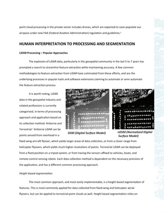
"Types of LiDAR." ArcGIS Help 10.1. N.p., n.d. Web. 14 Dec. 2012.
8
Schwallbe, Ellen, Haans-Gerd Maas, and Frank Seidel. "3D Building Model Generation from Airborne Laser
Scanner Data using 2D GIS data and Orthogonal Point cloud projections." ISPRS. Conference Proceedings.
9
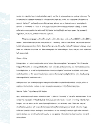
Morgan, Michael, and Ayman Habib. "Interpolation of LiDAR Data and Automated Building Extraction." Ohio State
University - Department of Civil and Material Engineering (n.d.): n. pag. Web.
10
Schwallbe, Ellen, Haans-Gerd Maas, and Frank Seidel. "3D Building Model Generation from Airborne Laser
Scanner Data using 2D GIS data and Orthogonal Point cloud projections." ISPRS. Conference Proceedings.
11
"DARPA Urban Challenge 2008." Welcome. Defense Advanced Research Projects Agency, n.d. Web. 14 Dec. 2012.
12
Wills, Danyll. "New Google Smart Phone Recognizes Your Face." MIT Technology Review. Massachusetts Institute
of Technology, 19 Oct. 2011. Web. 14 Dec. 2012.
13
Greenemeier, Larry, and Scientific American. "Something in the Way You Move: Cameras May Soon Recognize
Criminals by Their Gait." PBS. PBS, 29 Sept. 2011. Web. 14 Dec. 2012.](https://image.slidesharecdn.com/mikebularzlidarprocessingpaperdec2012-130115021500-phpapp02/85/LiDAR-Data-Processing-and-Classification-15-320.jpg)

This document discusses techniques for interpreting point cloud and image data through automated algorithms that translate human visual interpretations. It describes popular approaches for processing LiDAR point clouds, including height-based segmentation to classify features above the ground and shape-fitting algorithms. It also discusses using spectral information through intensity values or image fusion. Finally, it examines developing "computer vision" tools that can segment data based on visual cues humans use like color, texture, morphology, context and defined shapes. The goal is to replicate human visual interpretation abilities through algorithms.


