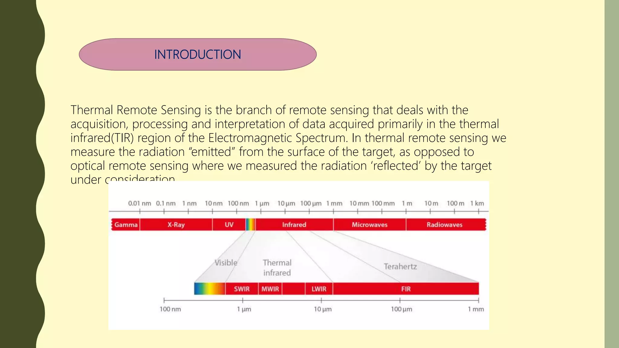
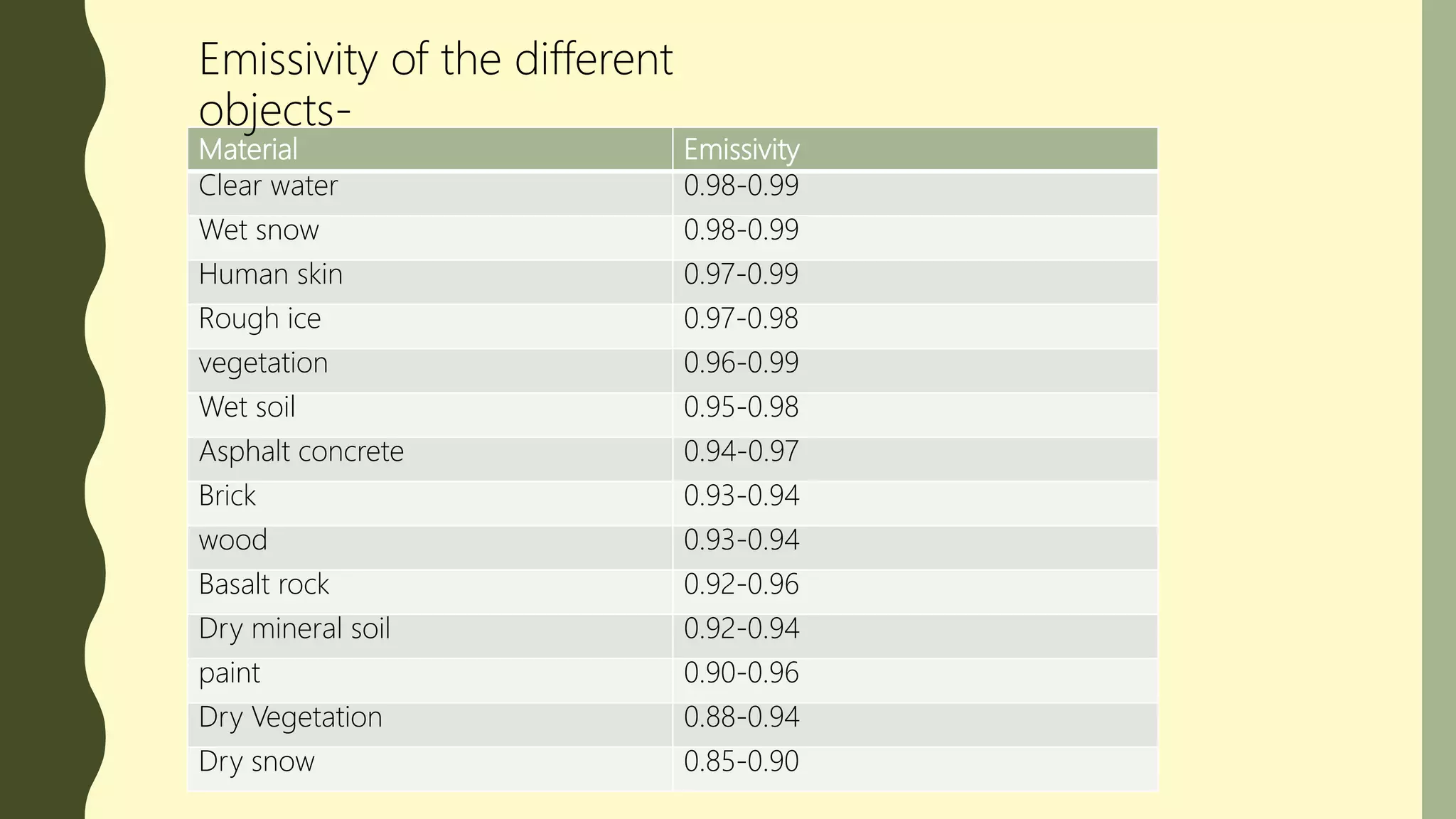
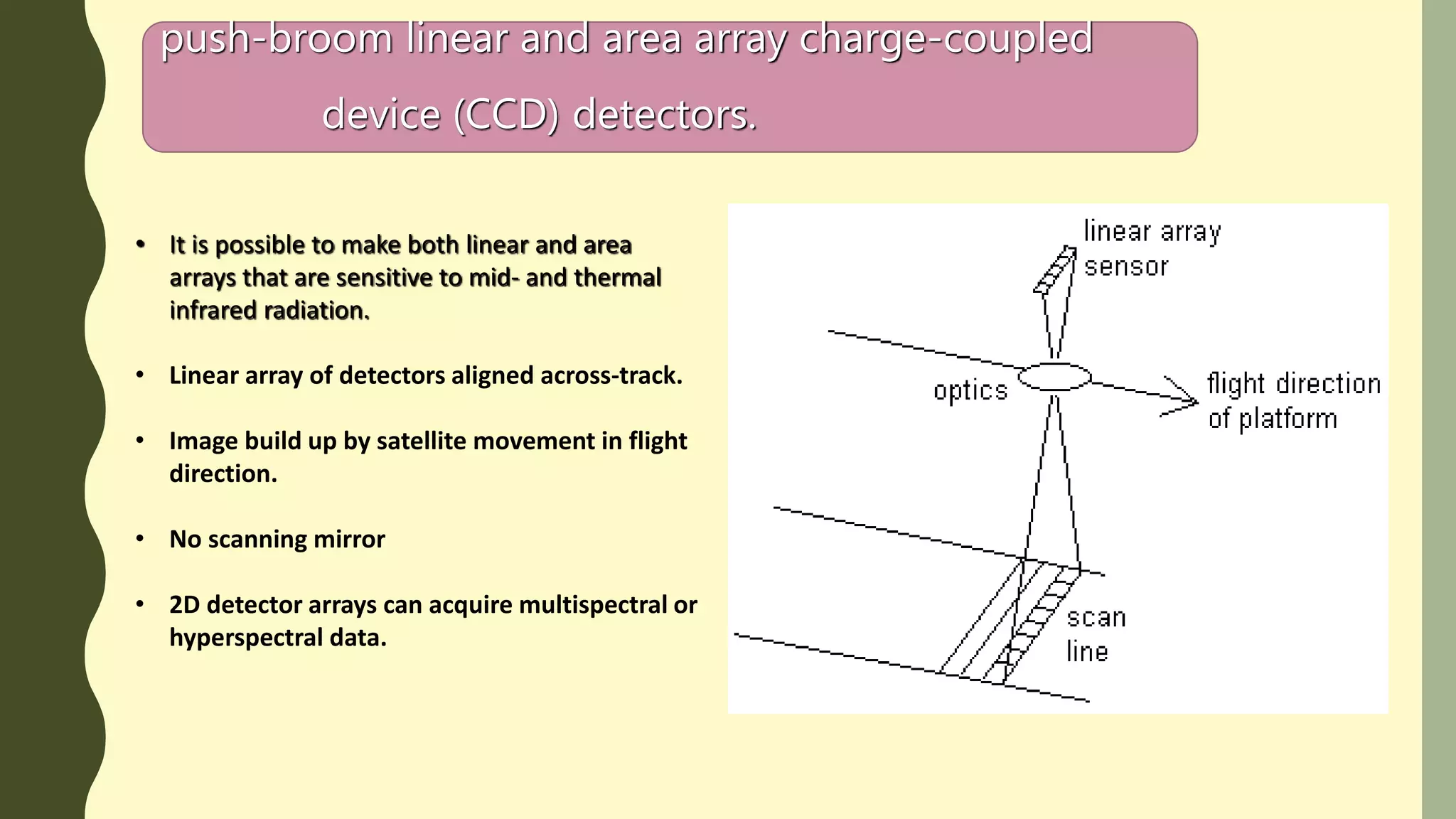
THERMAL INFRARED REMOTE SENSING
INTRODUCTION
Thermal Remote Sensing is the branch of remote sensing that deals with the
acquisition, processing and interpretation of data acquired primarily in the thermal
infrared(TIR) region of the Electromagnetic Spectrum. In thermal remote sensing we
measure the radiation “emitted” from the surface of the target, as opposed to
optical remote sensing where we measured the radiation ‘reflected’ by the target
under consideration.
And the black areas in denote the region of spectrum where the
atmosphere absorbs most of the infrared energy. Water vapor(H2O),CO2
and O3 are responsible for most of the absorption.
In the Thermal Infrared region has two primary thermal infrared
windows: 3-5µm. And 8-14µm.
Kinetic Heat, Radiant Temperature and Emissivity
Thermal Remote Sensing it’s basically depends upon Kinetic
Heat and Radiant Temperature..
Kinetic Heat
All objects in the real world having a
temperature above absolute zero. The
energy of particles of molecular matter in
random motion is called kinetic heat. Also
it is called internal,real,or true heat.
Concentration of kinetic temperature is
measure by thermometer.
Radiant Temperature/Energy
The internal kinetic heat also converted
to radiant energy, it is also called the
external or apparent energy.
We can utilize the “Radiometer” for
measuring the Radiant temperature
placed at a some distance from the
object.
Fig. Radiant energy exiting. a) water, b) granite, c) dunite
heated to 350K compared with a blackbody to the same
temperature (Jensen,2003).
Emissivity
The relationship between kinetic temperature and radiant temperature is not
perfect. The remote measurement of the radiant temperature always less than
the true kinetic temperature. So it is the ratio between of Radiant temperature
and the True Kinetic temperature.
Emissivity is differ by the different objects on the earth surface.
Factors
1.Colour
2.Moisture content
3.Comcaction
4.Field of view
5.Wave length
6.Viewing angle
7.Surface Ruggedness
Why do we need to know about
Emissivity?
Two objects laying next to one another
(e.g:two rocks) could have the same kinetic
temperature but different
apparent/radiant temperature because
their emissivities vary,,
Material Emissivity
Clear water 0.98-0.99
Wet snow 0.98-0.99
Human skin 0.97-0.99
Rough ice 0.97-0.98
vegetation 0.96-0.99
Wet soil 0.95-0.98
Asphalt concrete 0.94-0.97
Brick 0.93-0.94
wood 0.93-0.94
Basalt rock 0.92-0.96
Dry mineral soil 0.92-0.94
paint 0.90-0.96
Dry Vegetation 0.88-0.94
Dry snow 0.85-0.90
Emissivity of the different
objects-
Black Body
• Blackbody is a theoretical construct that absorbs all the
radiant energy striking it and radiates energy at the
maximum possible rate per unit area at each
wavelength for any given temp.
• No objects in nature are true blackbodies.
• Emissivity of blackbody is always ‘1’.
• Several objects like clean water or deep water which are
near to the blackbody concept. But they are not the
black body.
Grey body
• Its reflects a small fraction of the total energy
stored by them
• Its depends upon on the wavelength of different
bands.
Is a type of radiation emitted by a surface
whose emissivity is distinctly varied for
different wavelengths..
Selective Radiation
A)Spectral emissivity of
a blackbody, a
graybody and a
selective radiator.
B) Spectral radiance
exitance distribution of
the blackbody,
graybody and
hypothetical selective
radiator.
THERMAL RADIATION LAWS
THERMAL PORPERTIES OF TERRAIN
Thermal Infrared Data Collection
Thermal infrared remote sensor data may be collected
by:
• across-track thermal scanners, and
• push-broom linear and area array charge-
coupled
device (CCD) detectors.
across-track/whiskbroom thermal scanners
• Use a rotating mirror to sweep along a line
or a series of adjacent lines traversing the
ground.
• The incoming energy is separated into
several spectral components that are
independently sensed.
• To separate thermal and non thermal energy
forms
push-broom linear and area array charge-coupled
device (CCD) detectors.
• It is possible to make both linear and area
arrays that are sensitive to mid- and thermal
infrared radiation.
• Linear array of detectors aligned across-track.
• Image build up by satellite movement in flight
direction.
• No scanning mirror
• 2D detector arrays can acquire multispectral or
hyperspectral data.
Application
Agricultural purpose
Identification of water condition in the crop field.
Estimation of moisture amount in the crop
To find the appropriate time for irrigation
Detect the different types of disease in the agricultural
field
Crop maturity time identification, etc.
Identifying of natural
hazard
Volcanocity
Border security purposes
Weather forecasting
• Temperature
• Pressure
• Movement of the wind
• Prediction of Amount of rainfall
• Prediction of cyclone and tsunami
• Prediction of cloudiness
Others
• Identification of building materials
• Moisture condition of building
• Coal mining identify.
• Urban heat island effect.
URBAN HEAT ISLAND EFFECT
An urban heat island (UHI) is an urban
area or metropolitan area that is
significantly warmer than its
surrounding rural areas due to human
activities.
Thermal infrared image sources
 FLIR
 ATLAS
 LANDSAT ETM+
 LANDSAT 8 OLI
 ASTER
 AVHRR
 COASTAL ZONE COLOUR SCANNER(CZCS)
 OCEANSAT(ISRO)
Reference
Thermal remote sensing

Thermal remote sensing

  • 1.
  • 2.
    INTRODUCTION Thermal Remote Sensingis the branch of remote sensing that deals with the acquisition, processing and interpretation of data acquired primarily in the thermal infrared(TIR) region of the Electromagnetic Spectrum. In thermal remote sensing we measure the radiation “emitted” from the surface of the target, as opposed to optical remote sensing where we measured the radiation ‘reflected’ by the target under consideration.
  • 3.
    And the blackareas in denote the region of spectrum where the atmosphere absorbs most of the infrared energy. Water vapor(H2O),CO2 and O3 are responsible for most of the absorption. In the Thermal Infrared region has two primary thermal infrared windows: 3-5µm. And 8-14µm.
  • 4.
    Kinetic Heat, RadiantTemperature and Emissivity Thermal Remote Sensing it’s basically depends upon Kinetic Heat and Radiant Temperature.. Kinetic Heat All objects in the real world having a temperature above absolute zero. The energy of particles of molecular matter in random motion is called kinetic heat. Also it is called internal,real,or true heat. Concentration of kinetic temperature is measure by thermometer. Radiant Temperature/Energy The internal kinetic heat also converted to radiant energy, it is also called the external or apparent energy. We can utilize the “Radiometer” for measuring the Radiant temperature placed at a some distance from the object.
  • 5.
    Fig. Radiant energyexiting. a) water, b) granite, c) dunite heated to 350K compared with a blackbody to the same temperature (Jensen,2003).
  • 6.
    Emissivity The relationship betweenkinetic temperature and radiant temperature is not perfect. The remote measurement of the radiant temperature always less than the true kinetic temperature. So it is the ratio between of Radiant temperature and the True Kinetic temperature. Emissivity is differ by the different objects on the earth surface. Factors 1.Colour 2.Moisture content 3.Comcaction 4.Field of view 5.Wave length 6.Viewing angle 7.Surface Ruggedness Why do we need to know about Emissivity? Two objects laying next to one another (e.g:two rocks) could have the same kinetic temperature but different apparent/radiant temperature because their emissivities vary,,
  • 7.
    Material Emissivity Clear water0.98-0.99 Wet snow 0.98-0.99 Human skin 0.97-0.99 Rough ice 0.97-0.98 vegetation 0.96-0.99 Wet soil 0.95-0.98 Asphalt concrete 0.94-0.97 Brick 0.93-0.94 wood 0.93-0.94 Basalt rock 0.92-0.96 Dry mineral soil 0.92-0.94 paint 0.90-0.96 Dry Vegetation 0.88-0.94 Dry snow 0.85-0.90 Emissivity of the different objects-
  • 8.
    Black Body • Blackbodyis a theoretical construct that absorbs all the radiant energy striking it and radiates energy at the maximum possible rate per unit area at each wavelength for any given temp. • No objects in nature are true blackbodies. • Emissivity of blackbody is always ‘1’. • Several objects like clean water or deep water which are near to the blackbody concept. But they are not the black body.
  • 9.
    Grey body • Itsreflects a small fraction of the total energy stored by them • Its depends upon on the wavelength of different bands. Is a type of radiation emitted by a surface whose emissivity is distinctly varied for different wavelengths.. Selective Radiation
  • 10.
    A)Spectral emissivity of ablackbody, a graybody and a selective radiator. B) Spectral radiance exitance distribution of the blackbody, graybody and hypothetical selective radiator.
  • 11.
  • 14.
  • 15.
    Thermal Infrared DataCollection Thermal infrared remote sensor data may be collected by: • across-track thermal scanners, and • push-broom linear and area array charge- coupled device (CCD) detectors.
  • 16.
    across-track/whiskbroom thermal scanners •Use a rotating mirror to sweep along a line or a series of adjacent lines traversing the ground. • The incoming energy is separated into several spectral components that are independently sensed. • To separate thermal and non thermal energy forms
  • 17.
    push-broom linear andarea array charge-coupled device (CCD) detectors. • It is possible to make both linear and area arrays that are sensitive to mid- and thermal infrared radiation. • Linear array of detectors aligned across-track. • Image build up by satellite movement in flight direction. • No scanning mirror • 2D detector arrays can acquire multispectral or hyperspectral data.
  • 18.
    Application Agricultural purpose Identification ofwater condition in the crop field. Estimation of moisture amount in the crop To find the appropriate time for irrigation Detect the different types of disease in the agricultural field Crop maturity time identification, etc. Identifying of natural hazard Volcanocity
  • 19.
    Border security purposes Weatherforecasting • Temperature • Pressure • Movement of the wind • Prediction of Amount of rainfall • Prediction of cyclone and tsunami • Prediction of cloudiness Others • Identification of building materials • Moisture condition of building • Coal mining identify. • Urban heat island effect.
  • 20.
    URBAN HEAT ISLANDEFFECT An urban heat island (UHI) is an urban area or metropolitan area that is significantly warmer than its surrounding rural areas due to human activities.
  • 21.
    Thermal infrared imagesources  FLIR  ATLAS  LANDSAT ETM+  LANDSAT 8 OLI  ASTER  AVHRR  COASTAL ZONE COLOUR SCANNER(CZCS)  OCEANSAT(ISRO)
  • 22.