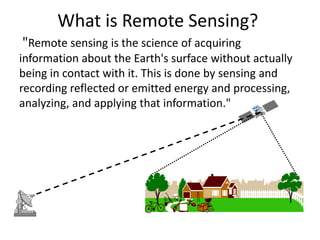
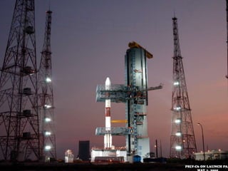
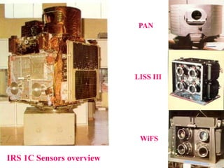
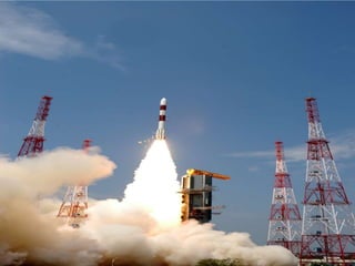
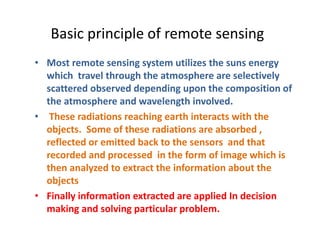
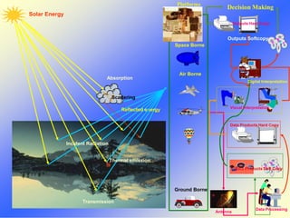
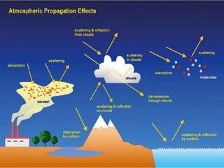
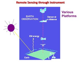
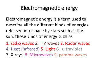
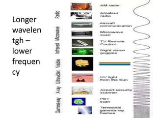
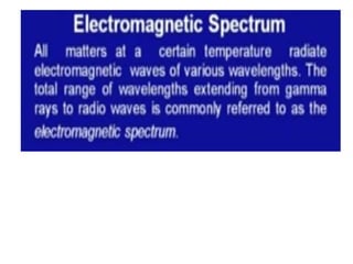
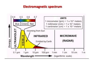
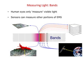
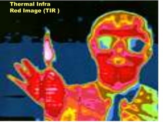
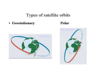
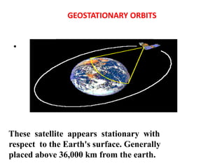
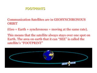
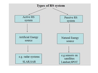
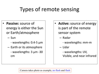
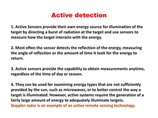
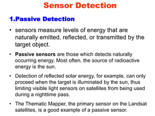
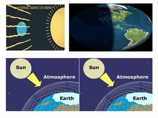
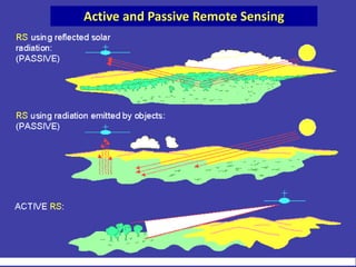
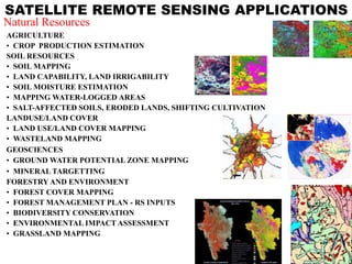
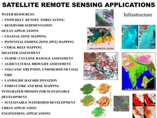
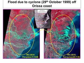
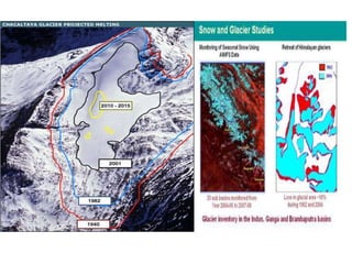
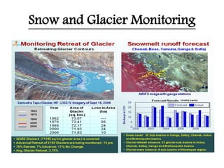
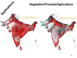
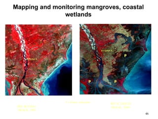
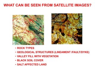
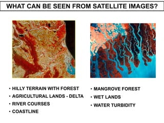
Remote Sensing
Manishkumar Dubey
MANISHKUMAR DUBEY
What is Remote Sensing?
"Remote sensing is the science of acquiring
information about the Earth's surface without actually
being in contact with it. This is done by sensing and
recording reflected or emitted energy and processing,
analyzing, and applying that information."
1903 - The Bavarian Pigeon Corps
H
I
S
T
O
R
Y
IRS 1C Sensors overview
PAN
LISS III
WiFS
Basic principle of remote sensing
• Most remote sensing system utilizes the suns energy
which travel through the atmosphere are selectively
scattered observed depending upon the composition of
the atmosphere and wavelength involved.
• These radiations reaching earth interacts with the
objects. Some of these radiations are absorbed ,
reflected or emitted back to the sensors and that
recorded and processed in the form of image which is
then analyzed to extract the information about the
objects
• Finally information extracted are applied In decision
making and solving particular problem.
Solar Energy
Incident Radiation
Absorption
Scattering
Reflected energy
Thermal emission
Transmission
Platforms
& Sensors
Ground Borne
Air Borne
Space Borne
Antenna
Data Processing
Data Products Soft Copy
Data Products Hard Copy
Visual Interpretation
Digital Interpretation
Outputs Softcopy
Outputs Hard Copy
Decision Making
Remote Sensing through instrument
Various
Platforms
Electromagnetic energy
Electromagnetic energy is a term used to
describe all the different kinds of energies
released into space by stars such as the
sun. these kinds of energy such as
1. radio waves 2. TV waves 3. Radar waves
4. Heat (infrared) 5. Light 6. ultraviolet
7. X-rays 8. Microwaves 9. gamma waves
Longer
wavelen
tgh –
lower
frequen
cy
Electromagnetic spectrum
Measuring Light: Bands
• Human eyes only ‘measure’ visible light
• Sensors can measure other portions of EMS
Bands
Thermal Infra
Red Image (TIR )
GEOSTATIONARY ORBITS
•
These satellite appears stationary with
respect to the Earth's surface. Generally
placed above 36,000 km from the earth.
FOOTPRINTS
Communication Satellites are in GEOSYNCHRONOUS
ORBIT
(Geo = Earth + synchronous = moving at the same rate).
This means that the satellite always stays over one spot on
Earth. The area on earth that it can “SEE” is called the
satellite’s “FOOTPRINT”
A Polar Orbit is a particular type of Low
Earth Orbit. The satellite travels a North –
South Direction, rather than more common
East-West Direction.
• As the satellite revolves around the Earth, the sensor
"sees" a certain portion of the Earth's surface.
• The width of the strip imaged is referred to as the swath
width.
SWATH
SIX STAGES IN REMOTE SENSING
Stage-1. Source of energy
Stage-2. Transmission of EMR towards the Object
Stage-3. Interaction of EMR with the Object
Stage-4. Transmission of Interacted EMR towards the
Sensor
Stage-5. Recording of the Image by the Detector
Stage-6. Analysis of the Imagery
1
2
3
4
5 (Film)
6
3
3
4
Types of remote sensing
• Passive: source of
energy is either the Sun
or Earth/atmosphere
– Sun
- wavelengths: 0.4-5 µm
– Earth or its atmosphere
- wavelengths: 3 µm -30
cm
• Active: source of energy
is part of the remote
sensor system
– Radar
- wavelengths: mm-m
– Lidar
- wavelengths: UV,
Visible, and near infrared
Camera takes photo as example, no flash and flash
Active detection
1. Active Sensors provide their own energy source for illumination of the
target by directing a burst of radiation at the target and use sensors to
measure how the target interacts with the energy.
2. Most often the sensor detects the reflection of the energy, measuring
the angle of reflection or the amount of time it took for the energy to
return.
3. Active sensors provide the capability to obtain measurements anytime,
regardless of the time of day or season.
4. They can be used for examining energy types that are not sufficiently
provided by the sun, such as microwaves, or to better control the way a
target is illuminated. However, active systems require the generation of a
fairly large amount of energy to adequately illuminate targets.
Doppler radar is an example of an active remote sensing technology.
GROUND PENETRATING RADAR
(GPR)
Active Remote Sensing
Sensor Detection
1.Passive Detection
• sensors measure levels of energy that are
naturally emitted, reflected, or transmitted by the
target object.
• Passive sensors are those which detects naturally
occurring energy. Most often, the source of radioactive
energy is the sun.
• Detection of reflected solar energy, for example, can only
proceed when the target is illuminated by the sun, thus
limiting visible light sensors on satellites from being used
during a nighttime pass.
• The Thematic Mapper, the primary sensor on the Landsat
satellites, is a good example of a passive sensor.
Active and Passive Remote Sensing
USUAL PLATFORMS
• Aircraft
– Helicopters
– Microlites
– Low altitude aircrafts
– High altitude aircraft
• Satellites
– Orbiting satellites
– Geostationary satellites
Application of Remote Sensing in civil
Engineering
Various civil engineering application areas include
1. Urban/ Regional planning 2. site investigation 3. terrain
mapping and analysis 4. water resources engineering
5. town planning and urban infrastructure development,
6. transportation network analysis 7. landslide analysis.
Regional Planning and Site Investigations: Site
investigations in general require topographic and geologic
considerations. Remote sensing data permits such an
assessment.
In case of dam site investigation, information on
topography is essential. Geological consideration involves
the different soil and rock types and physical properties
Image source: www.ldeo.columbia.edu
Image source: www.geospectra.net
• In selecting river-crossing sites for bridges and pipelines, an
important consideration is the stability of slopes leading down to
and up from the water crossing. Such slopes include riverbanks,
terrace faces and valley wall. History of river erosion and
sedimentation would give clues needed for locating the sites where
scour is likely to occur. High spatial resolution satellite data with
stereo vision capability can facilitate depth perception in the above
said investigations and also for regional planning of large
commercial airports, harbors, industrial towns and recreational
sites.
• The hydro geological and geomorphologic information along with
geological structures derived from satellite data are very useful in
sitting the ground – water bore holes.
• Terrain Mapping and Analysis Assessment of the performance of
the terrain for specific developmental activities can be made
through terrain evaluation. For this, terrain information can be
acquired from RS data and by generating the Digital Terrain Model
• In engineering construction like dam, the knowledge of material
comprising the terrain is essential for proper planning, location,
construction and maintenance of engineering facilities.
• For computation of hydrograph parameters like peak runoff rate,
time of concentration and time to peak, the height and slope
information derived from Digital Elevation Model (DEM) are useful.
• In large area reconnaissance studies, various technically feasible and
economically viable alternatives in locating surplus flow diversion
routes to water deficient basins can be arrived at.
• projects of large dimensions require considerations of land use /
land cover, soil and geological mapping, terrain evaluation,
construction material inventory etc. the latter are derived from
satellite remote sensing data of particular resolution depending
upon the scale on which such information is required
Advantages of Remote Sensing
• Provides a view for the large region
• Offers Geo-referenced information and digital
information
• Most of the remote sensors operate in every
season, every day, every time and even in real
tough weather
• Easy acquisition of data over inaccessible
areas
• A single data can be used for different uses
SATELLITE REMOTE SENSING APPLICATIONS
AGRICULTURE
• CROP PRODUCTION ESTIMATION
SOIL RESOURCES
• SOIL MAPPING
• LAND CAPABILITY, LAND IRRIGABILITY
• SOIL MOISTURE ESTIMATION
• MAPPING WATER-LOGGED AREAS
• SALT-AFFECTED SOILS, ERODED LANDS, SHIFTING CULTIVATION
LANDUSE/LAND COVER
• LAND USE/LAND COVER MAPPING
• WASTELAND MAPPING
GEOSCIENCES
• GROUND WATER POTENTIAL ZONE MAPPING
• MINERAL TARGETTING
FORESTRY AND ENVIRONMENT
• FOREST COVER MAPPING
• FOREST MANAGEMENT PLAN - RS INPUTS
• BIODIVERSITY CONSERVATION
• ENVIRONMENTAL IMPACT ASSESSMENT
• GRASSLAND MAPPING
Natural Resources
SATELLITE REMOTE SENSING APPLICATIONS
WATER RESOURCES
• SNOWMELT RUNOFF FORECASTING
• RESERVOIR SEDIMENTATION
OCEAN APPLICATIONS
• COASTAL ZONE MAPPING
• POTENTIAL FISHING ZONE (PFZ) MAPPING
• CORAL REEF MAPPING
DISASTER ASSESSMENT
• FLOOD / CYCLONE DAMAGE ASSESSMENT
• AGRICULTURAL DROUGHT ASSESSMENT
• VOLCANIC ERUPTION, UNDERGROUND COAL
FIRE
• LANDSLIDE HAZARD ZONATION
• FOREST FIRE AND RISK MAPPING
INTEGRATED MISSION FOR SUSTAINABLE
DEVELOPMENT
• SUSTAINABLE WATERSHED DEVELOPMENT
URBAN APPLICATION
ENGINEERING APPLICATIONS
Infrastructure
Flood due to cyclone (29th October 1999) off
Orissa coast
IRS LISS III
Pre-cyclone (11.10.99)
IRS LISS III
Post-cyclone (05.11.99)
RADARSAT
DATA of 2nd NOV
Snow and Glacier Monitoring
45
Vegetation/Forests/Agriculture
Kharif-1999 (Sep-Oct) Rabi-2000 (Feb-Mar)
46
Mapping and monitoring mangroves, coastal
wetlands
PP
P
KRISHNA R.
IRS-1B LISS-I
IMAGE, 1992
KRISHNA R.
P = Prawn cultivation
IRS-1C LISS-III
IMAGE, 2000
• ROCK TYPES
• GEOLOGICAL STRUCTURES (LINEAMENT /FAULT/DYKE)
• VALLEY FILL WITH VEGETATION
• BLACK SOIL COVER
• SALT AFFECTED LAND
WHAT CAN BE SEEN FROM SATELLITE IMAGES?
• HILLY TERRAIN WITH FOREST
• AGRICULTURAL LANDS - DELTA
• RIVER COURSES
• COASTLINE
WHAT CAN BE SEEN FROM SATELLITE IMAGES?
• MANGROVE FOREST
• WET LANDS
• WATER TURBIDITY
Land Use
Land cover means any surface cover on the ground
which can include vegetation, urban infrastructure,
water, lake, mountain, transportation networks,
buildings or any other. The attributes measured by
remote sensing techniques relate to land cover,
from which land use can be inferred, particularly
with ancillary data or a priori cognition.
Application of Remote Sensing
Mapping
Generating different maps from
remotely sensed data can be so
effective ad valuable. A classification
of sensing elements and methodologies
to generate theses remotely sensed
models are essential for mapping. Two
primary methods of generating
elevation data are:
1. Stereogrammetry techniques by air
photos
2. Radar interferometry
Radar image of a continuously clouded area
Map with the road network
 Wageningen UR 2002
52
But may be easier than we think…
to use Technology
THANK YOU

Remote sensing in Civil Engineering

  • 1.
  • 2.
    What is RemoteSensing? "Remote sensing is the science of acquiring information about the Earth's surface without actually being in contact with it. This is done by sensing and recording reflected or emitted energy and processing, analyzing, and applying that information."
  • 3.
    1903 - TheBavarian Pigeon Corps H I S T O R Y
  • 5.
    IRS 1C Sensorsoverview PAN LISS III WiFS
  • 7.
    Basic principle ofremote sensing • Most remote sensing system utilizes the suns energy which travel through the atmosphere are selectively scattered observed depending upon the composition of the atmosphere and wavelength involved. • These radiations reaching earth interacts with the objects. Some of these radiations are absorbed , reflected or emitted back to the sensors and that recorded and processed in the form of image which is then analyzed to extract the information about the objects • Finally information extracted are applied In decision making and solving particular problem.
  • 8.
    Solar Energy Incident Radiation Absorption Scattering Reflectedenergy Thermal emission Transmission Platforms & Sensors Ground Borne Air Borne Space Borne Antenna Data Processing Data Products Soft Copy Data Products Hard Copy Visual Interpretation Digital Interpretation Outputs Softcopy Outputs Hard Copy Decision Making
  • 10.
    Remote Sensing throughinstrument Various Platforms
  • 11.
    Electromagnetic energy Electromagnetic energyis a term used to describe all the different kinds of energies released into space by stars such as the sun. these kinds of energy such as 1. radio waves 2. TV waves 3. Radar waves 4. Heat (infrared) 5. Light 6. ultraviolet 7. X-rays 8. Microwaves 9. gamma waves
  • 12.
  • 14.
  • 15.
    Measuring Light: Bands •Human eyes only ‘measure’ visible light • Sensors can measure other portions of EMS Bands
  • 16.
  • 18.
    GEOSTATIONARY ORBITS • These satelliteappears stationary with respect to the Earth's surface. Generally placed above 36,000 km from the earth.
  • 19.
    FOOTPRINTS Communication Satellites arein GEOSYNCHRONOUS ORBIT (Geo = Earth + synchronous = moving at the same rate). This means that the satellite always stays over one spot on Earth. The area on earth that it can “SEE” is called the satellite’s “FOOTPRINT”
  • 20.
    A Polar Orbitis a particular type of Low Earth Orbit. The satellite travels a North – South Direction, rather than more common East-West Direction.
  • 22.
    • As thesatellite revolves around the Earth, the sensor "sees" a certain portion of the Earth's surface. • The width of the strip imaged is referred to as the swath width. SWATH
  • 23.
    SIX STAGES INREMOTE SENSING Stage-1. Source of energy Stage-2. Transmission of EMR towards the Object Stage-3. Interaction of EMR with the Object Stage-4. Transmission of Interacted EMR towards the Sensor Stage-5. Recording of the Image by the Detector Stage-6. Analysis of the Imagery 1 2 3 4 5 (Film) 6 3 3 4
  • 25.
    Types of remotesensing • Passive: source of energy is either the Sun or Earth/atmosphere – Sun - wavelengths: 0.4-5 µm – Earth or its atmosphere - wavelengths: 3 µm -30 cm • Active: source of energy is part of the remote sensor system – Radar - wavelengths: mm-m – Lidar - wavelengths: UV, Visible, and near infrared Camera takes photo as example, no flash and flash
  • 26.
    Active detection 1. ActiveSensors provide their own energy source for illumination of the target by directing a burst of radiation at the target and use sensors to measure how the target interacts with the energy. 2. Most often the sensor detects the reflection of the energy, measuring the angle of reflection or the amount of time it took for the energy to return. 3. Active sensors provide the capability to obtain measurements anytime, regardless of the time of day or season. 4. They can be used for examining energy types that are not sufficiently provided by the sun, such as microwaves, or to better control the way a target is illuminated. However, active systems require the generation of a fairly large amount of energy to adequately illuminate targets. Doppler radar is an example of an active remote sensing technology.
  • 27.
  • 28.
  • 29.
    Sensor Detection 1.Passive Detection •sensors measure levels of energy that are naturally emitted, reflected, or transmitted by the target object. • Passive sensors are those which detects naturally occurring energy. Most often, the source of radioactive energy is the sun. • Detection of reflected solar energy, for example, can only proceed when the target is illuminated by the sun, thus limiting visible light sensors on satellites from being used during a nighttime pass. • The Thematic Mapper, the primary sensor on the Landsat satellites, is a good example of a passive sensor.
  • 31.
    Active and PassiveRemote Sensing
  • 32.
    USUAL PLATFORMS • Aircraft –Helicopters – Microlites – Low altitude aircrafts – High altitude aircraft • Satellites – Orbiting satellites – Geostationary satellites
  • 33.
    Application of RemoteSensing in civil Engineering Various civil engineering application areas include 1. Urban/ Regional planning 2. site investigation 3. terrain mapping and analysis 4. water resources engineering 5. town planning and urban infrastructure development, 6. transportation network analysis 7. landslide analysis. Regional Planning and Site Investigations: Site investigations in general require topographic and geologic considerations. Remote sensing data permits such an assessment. In case of dam site investigation, information on topography is essential. Geological consideration involves the different soil and rock types and physical properties Image source: www.ldeo.columbia.edu Image source: www.geospectra.net
  • 34.
    • In selectingriver-crossing sites for bridges and pipelines, an important consideration is the stability of slopes leading down to and up from the water crossing. Such slopes include riverbanks, terrace faces and valley wall. History of river erosion and sedimentation would give clues needed for locating the sites where scour is likely to occur. High spatial resolution satellite data with stereo vision capability can facilitate depth perception in the above said investigations and also for regional planning of large commercial airports, harbors, industrial towns and recreational sites. • The hydro geological and geomorphologic information along with geological structures derived from satellite data are very useful in sitting the ground – water bore holes. • Terrain Mapping and Analysis Assessment of the performance of the terrain for specific developmental activities can be made through terrain evaluation. For this, terrain information can be acquired from RS data and by generating the Digital Terrain Model
  • 35.
    • In engineeringconstruction like dam, the knowledge of material comprising the terrain is essential for proper planning, location, construction and maintenance of engineering facilities. • For computation of hydrograph parameters like peak runoff rate, time of concentration and time to peak, the height and slope information derived from Digital Elevation Model (DEM) are useful. • In large area reconnaissance studies, various technically feasible and economically viable alternatives in locating surplus flow diversion routes to water deficient basins can be arrived at. • projects of large dimensions require considerations of land use / land cover, soil and geological mapping, terrain evaluation, construction material inventory etc. the latter are derived from satellite remote sensing data of particular resolution depending upon the scale on which such information is required
  • 36.
    Advantages of RemoteSensing • Provides a view for the large region • Offers Geo-referenced information and digital information • Most of the remote sensors operate in every season, every day, every time and even in real tough weather • Easy acquisition of data over inaccessible areas • A single data can be used for different uses
  • 39.
    SATELLITE REMOTE SENSINGAPPLICATIONS AGRICULTURE • CROP PRODUCTION ESTIMATION SOIL RESOURCES • SOIL MAPPING • LAND CAPABILITY, LAND IRRIGABILITY • SOIL MOISTURE ESTIMATION • MAPPING WATER-LOGGED AREAS • SALT-AFFECTED SOILS, ERODED LANDS, SHIFTING CULTIVATION LANDUSE/LAND COVER • LAND USE/LAND COVER MAPPING • WASTELAND MAPPING GEOSCIENCES • GROUND WATER POTENTIAL ZONE MAPPING • MINERAL TARGETTING FORESTRY AND ENVIRONMENT • FOREST COVER MAPPING • FOREST MANAGEMENT PLAN - RS INPUTS • BIODIVERSITY CONSERVATION • ENVIRONMENTAL IMPACT ASSESSMENT • GRASSLAND MAPPING Natural Resources
  • 40.
    SATELLITE REMOTE SENSINGAPPLICATIONS WATER RESOURCES • SNOWMELT RUNOFF FORECASTING • RESERVOIR SEDIMENTATION OCEAN APPLICATIONS • COASTAL ZONE MAPPING • POTENTIAL FISHING ZONE (PFZ) MAPPING • CORAL REEF MAPPING DISASTER ASSESSMENT • FLOOD / CYCLONE DAMAGE ASSESSMENT • AGRICULTURAL DROUGHT ASSESSMENT • VOLCANIC ERUPTION, UNDERGROUND COAL FIRE • LANDSLIDE HAZARD ZONATION • FOREST FIRE AND RISK MAPPING INTEGRATED MISSION FOR SUSTAINABLE DEVELOPMENT • SUSTAINABLE WATERSHED DEVELOPMENT URBAN APPLICATION ENGINEERING APPLICATIONS Infrastructure
  • 41.
    Flood due tocyclone (29th October 1999) off Orissa coast IRS LISS III Pre-cyclone (11.10.99) IRS LISS III Post-cyclone (05.11.99) RADARSAT DATA of 2nd NOV
  • 43.
    Snow and GlacierMonitoring
  • 44.
  • 45.
    46 Mapping and monitoringmangroves, coastal wetlands PP P KRISHNA R. IRS-1B LISS-I IMAGE, 1992 KRISHNA R. P = Prawn cultivation IRS-1C LISS-III IMAGE, 2000
  • 46.
    • ROCK TYPES •GEOLOGICAL STRUCTURES (LINEAMENT /FAULT/DYKE) • VALLEY FILL WITH VEGETATION • BLACK SOIL COVER • SALT AFFECTED LAND WHAT CAN BE SEEN FROM SATELLITE IMAGES?
  • 47.
    • HILLY TERRAINWITH FOREST • AGRICULTURAL LANDS - DELTA • RIVER COURSES • COASTLINE WHAT CAN BE SEEN FROM SATELLITE IMAGES? • MANGROVE FOREST • WET LANDS • WATER TURBIDITY
  • 48.
    Land Use Land covermeans any surface cover on the ground which can include vegetation, urban infrastructure, water, lake, mountain, transportation networks, buildings or any other. The attributes measured by remote sensing techniques relate to land cover, from which land use can be inferred, particularly with ancillary data or a priori cognition. Application of Remote Sensing
  • 50.
    Mapping Generating different mapsfrom remotely sensed data can be so effective ad valuable. A classification of sensing elements and methodologies to generate theses remotely sensed models are essential for mapping. Two primary methods of generating elevation data are: 1. Stereogrammetry techniques by air photos 2. Radar interferometry Radar image of a continuously clouded area Map with the road network  Wageningen UR 2002
  • 51.
    52 But may beeasier than we think… to use Technology
  • 53.