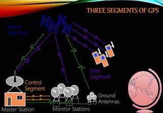
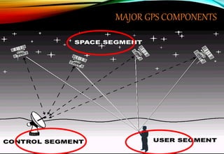
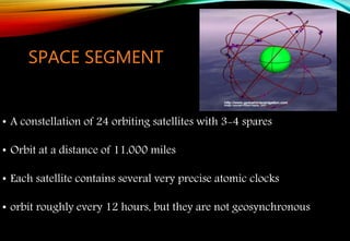
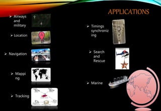
S.S.A.S.I.T, SURAT GTU
WHAT IS GPS
• GPS stands for Global Positioning System
• GPS is a satellite navigation system designed to provide
accurate position, velocity, and time information almost
anywhere in the world
• The Present System Is Known As NAVSTAR - Navigation
Satellite Timing And Ranging
• The Gps Program operated and controlled by the US
Department of Defense
Control
Segment
Space
Segment
User
Segment
THREE SEGMENTS OF GPS
Monitor Stations
Ground
Antennas
Master Station
MAJOR GPS COMPONENTS
SPACE SEGMENT
• A constellation of 24 orbiting satellites with 3-4 spares
• Orbit at a distance of 11,000 miles
• Each satellite contains several very precise atomic clocks
• orbit roughly every 12 hours, but they are not geosynchronous
 The control segment comprises of 5 ground stations located on
equator.(4-monitor and 1-master station)
 Monitor stations measure the distances of the overhead satellites
every 1.5 seconds and send the corrected data to Master station.
 In Master station the satellite orbit, clock performance and health
of the satellite are determined and determines whether
repositioning is required.
 This information is sent back to the satellites using ground
antennas.
Control Segment
User Segment
 The User Segment consists of all earth-based GPS receivers.
 The user segment is totally user community, both civilian
and military.
INFORMATION IN A GPS SIGNAL
The GPS signal contains mainly two types of data, they are:
Ephemeris data
Almanac data
Ephemeris data is constantly transmitted by each satellite and
contains important information such as status of the satellite
(healthy or unhealthy), current date, and time. This part of the
signal is essential to determining a position.
Almanac data tells the GPS receiver where each GPS satellite
should be at any time throughout the day. Each satellite transmits
almanac data showing the orbital information of that satellite.
How GPS Works
Satellites
broadcast
• Precise time
• Orbit data
• Satellite
health
Receiver measures
time delay from
satellites, and by
triangulation
calculates
• Location
• Elevation
• Velocity
HOW GPS WORKS(CONTINUE)
The GPS uses technique of "triangulation" to find
location.
To "triangulate," a GPS receiver measures distance from
the satellite using the travel time of radio signals.
To measure travel time, GPS needs very accurate timing,
which is provided by atomic clocks used in the satellites.
Along with distance, we need to know exactly where the
satellites are in space. This information is obtained by Almanac
data transmitted by satellites.
Finally we must correct for any delays the signal experiences
as it travels through the atmosphere.
To compute a positions in three dimensions. We need to have
four satellite measurements. The GPS uses a trigonometric
approach to calculate the positions.
The receiver is
somewhere on
this sphere.
Signal From One Satellite
Signals From Two Satellites
Three Satellites (2D Positioning) Three Dimensional (3D) Positioning
TRIANGLATION
APPLICATIONS
 Location
 Mappi
ng
 Tracking
 Navigation
 Marine
 Timings
synchroniz
ing
 Search
and
Rescue
 Airways
and
military
Ch 5 a gps

Ch 5 a gps

  • 1.
  • 2.
    WHAT IS GPS •GPS stands for Global Positioning System • GPS is a satellite navigation system designed to provide accurate position, velocity, and time information almost anywhere in the world • The Present System Is Known As NAVSTAR - Navigation Satellite Timing And Ranging • The Gps Program operated and controlled by the US Department of Defense
  • 3.
    Control Segment Space Segment User Segment THREE SEGMENTS OFGPS Monitor Stations Ground Antennas Master Station
  • 4.
  • 5.
    SPACE SEGMENT • Aconstellation of 24 orbiting satellites with 3-4 spares • Orbit at a distance of 11,000 miles • Each satellite contains several very precise atomic clocks • orbit roughly every 12 hours, but they are not geosynchronous
  • 6.
     The controlsegment comprises of 5 ground stations located on equator.(4-monitor and 1-master station)  Monitor stations measure the distances of the overhead satellites every 1.5 seconds and send the corrected data to Master station.  In Master station the satellite orbit, clock performance and health of the satellite are determined and determines whether repositioning is required.  This information is sent back to the satellites using ground antennas. Control Segment
  • 7.
    User Segment  TheUser Segment consists of all earth-based GPS receivers.  The user segment is totally user community, both civilian and military.
  • 8.
    INFORMATION IN AGPS SIGNAL The GPS signal contains mainly two types of data, they are: Ephemeris data Almanac data
  • 9.
    Ephemeris data isconstantly transmitted by each satellite and contains important information such as status of the satellite (healthy or unhealthy), current date, and time. This part of the signal is essential to determining a position. Almanac data tells the GPS receiver where each GPS satellite should be at any time throughout the day. Each satellite transmits almanac data showing the orbital information of that satellite.
  • 10.
    How GPS Works Satellites broadcast •Precise time • Orbit data • Satellite health Receiver measures time delay from satellites, and by triangulation calculates • Location • Elevation • Velocity
  • 11.
    HOW GPS WORKS(CONTINUE) TheGPS uses technique of "triangulation" to find location. To "triangulate," a GPS receiver measures distance from the satellite using the travel time of radio signals. To measure travel time, GPS needs very accurate timing, which is provided by atomic clocks used in the satellites.
  • 12.
    Along with distance,we need to know exactly where the satellites are in space. This information is obtained by Almanac data transmitted by satellites. Finally we must correct for any delays the signal experiences as it travels through the atmosphere. To compute a positions in three dimensions. We need to have four satellite measurements. The GPS uses a trigonometric approach to calculate the positions.
  • 13.
    The receiver is somewhereon this sphere. Signal From One Satellite Signals From Two Satellites Three Satellites (2D Positioning) Three Dimensional (3D) Positioning TRIANGLATION
  • 15.
    APPLICATIONS  Location  Mappi ng Tracking  Navigation  Marine  Timings synchroniz ing  Search and Rescue  Airways and military