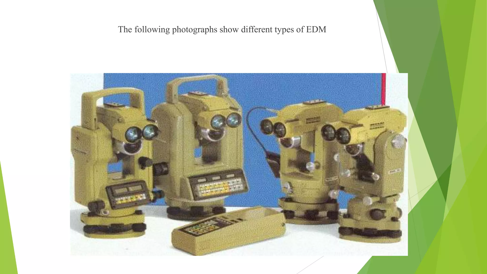
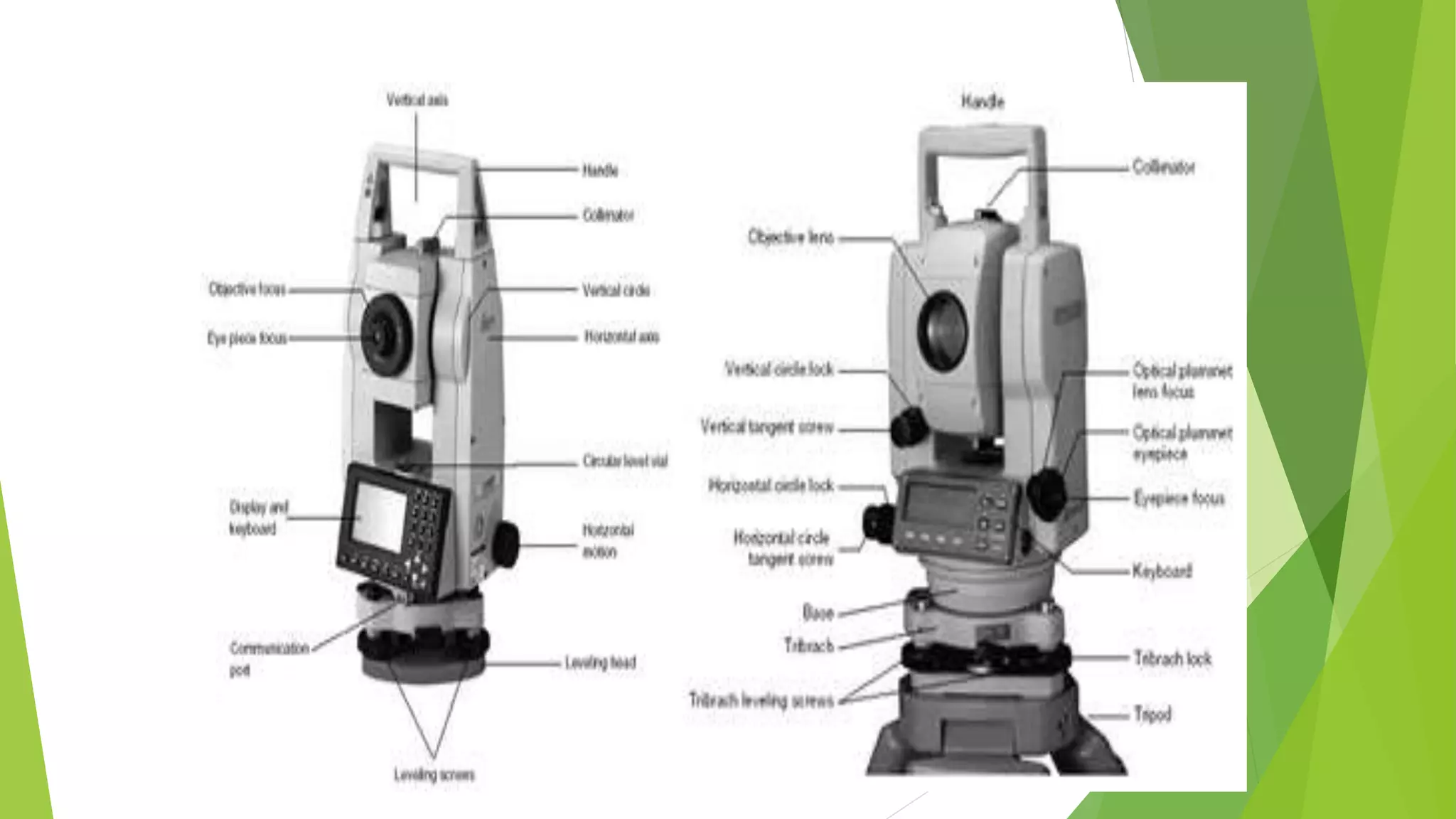
SlideShare a Scribd company logo
1 of 26
TOPIC : Modern Surveying Instruments
SUBJECT : Advanced Surveying
Student name
Pansuriya Mayank 141100106044
Parmar Parimal 141100106045
Patel Dhanik 141100106055
Kotila Jayvir 151103106008
Mistry Aditya 151103106009
Pandya Dhrumil 151103106010
Content
-Introduction
-Electromagnetic wave
-Properties of Electromagnetic Waves
-Principle of EDM
-Types of EDM Instruments
-Total Station
-Types of Total Station
-Measuring Angle
-Advantages and Disadvantages
-Digitals self and Levelling level
MODERN SURVEYING EQUIPMENT
 Revolutionary changes have taken place in last few
years in surveying instruments that are used for
measuring level differences, distances and angles.
 This has become possible because of introduction of
electronics in these measurements. With rapid
advancements in the technology and availability of
cheaper and innovative electronic components, these
instruments have become affordable and easy to use.
Introduction
 Direct distance measurement
 Optical distance measurement
 Electronic distance measurement
Electromagnetic waves
 The EDM method is based on generation, propagation,
reflection and subsequent reception of electromagnetic
waves
 The distance is measured indirectly using the
characteristics of these waves
 The electromagnetic waves required no medium and they
can travel even in vacuum
Properties of electromagnetic wave
 Cycle : when the wave moves through two identical point
on its path it is said to have completed one cycle.
 Wave length : the distance two identical points on a wave
is called wave length.
 Frequency : frequency refers to the number of cycles of
wave passing a fixed point per unit time it is denoted by
the Greek letter nu.
PRINCIPLE OF EDM
 The general principle involves sending a modulated Electro-
magnetic (EM) beam from one transmitter at the master station
to a reflector at the remote station and receiving it back at the
master station.
 The instrument measures slope distance between transmitter
and receiver by modulating the continuous carrier wave at
different frequencies, and then measuring the phase difference
at the master station between the outgoing and the incoming
signals. This establishes the following relationship for a double
distance (2D)
Types of EDM instrument
1. Micro Wave Instruments
2. Infrared Wave Instruments
3. Light Wave Instruments
Micro Wave Instruments
 These instruments make use of micro
waves.
 Tellurometers come under this
category.
 Tellurometers can be used in day as
well as in night.
 The range of these instruments is up to
100 km.
Infrared Wave Instruments
 In this instrument amplitude modulated infrared waves
are used.
 Prism reflectors are used at the end of line to be
measured.
 These instruments are light and economical and can be
mounted on theodolite.
 With these instruments accuracy achieved is ± 10 mm.
The range of these instruments is up to 3 km.
Light Wave Instruments
 These instruments rely on propagation of modulated light
waves.
 During night its range is up to 2.5 km while in day its
range is up to 3 km.
 Accuracy of these instruments varies from 0.5 mm to 5
mm/km distance.
The following photographs show different types of EDM
Total station
TOTAL STATION
 These instruments can record horizontal and vertical angles
together with slope distance and can be considered as combined
EDM plus electronic theodolite.
 The microprocessor in TS can perform various mathematical
operations such as averaging, multiple angle and distance
measurements, horizontal and vertical distances, X, Y, Z
coordinates, distance between observed points and corrections for
atmospheric and instrumental corrections.
Advantages of total station
 Area of the field can be computed.
 Automation of old maps.
 Graphical view of plots and land for quick visualization.
 Local language support.
 Full GIS creation using map info software.
 The instruments can be easily set on tripod using laser
plumber.
Disadvantages of total station
 For on overall check of the survey, it will be necessary to return
to the office and prepare the drawing using appropriate
software.
 The instrument is costly.
 Skilled personnel are required for conducting surveys.
Measuring angles
 For measuring angles optoelectronically, the absolute
circle scanning system used to read the coded graduations
of a glass circle.
 The circle contains only one coded graduation track which
contains all the information's.
 The code is read by linear CCD array and an analogue to
digital converter and displays with maximum accuracy.
Types of total stations
 Manual total stations
 Semi-automatic total stations
 Automatic total stations
Manual total stations
 In this type of total stations it was necessary to read the
horizontal and vertical angles manually.
 Only slope distance could be read electronically.
Semi-automatic total station
 For these instruments the user had to manually read the
horizontal circle.
 Vertical circle reading were shown digitally.
 Slope distances with their horizontal and vertical
components are displayed digitally.
Automatic total stations
 This type is the most common total station used now-a-
days.
 They sense both horizontal and vertical angle
electronically.
 The coordinate information obtained can either be stored
in the total stations memory card.
DIGITAL LEVEL
 Recently electronic digital levels have evolved as a result of
development in electronics and digital image processing.
 Digital levels use electronic image processing to evaluate the
special bar-coded staff reading.
 This bar-coded pattern is converted into elevation and distance
values using a digital image matching procedure within the
instrument.
 Various capabilities of digital levels are as follows:
1. measuring elevation.
2. measuring height difference.
3. measuring height difference with multiple instrument
positions.
4. levelling
6. setting out with horizontal distance
7. levelling of ceilings
Modern surveying instruments

More Related Content

What's hot

Triangulation and trilateration pdf...
Triangulation and trilateration pdf...Triangulation and trilateration pdf...
Triangulation and trilateration pdf...
Gokul Saud
 
Total station topcon exp procedures
Total station topcon exp proceduresTotal station topcon exp procedures
Total station topcon exp procedures
NAGESH KUMAR GUTURU
 

What's hot (20)

Triangulation and trilateration pdf...
Triangulation and trilateration pdf...Triangulation and trilateration pdf...
Triangulation and trilateration pdf...
 
Hydrographics surveying
Hydrographics surveyingHydrographics surveying
Hydrographics surveying
 
Total station Surveying
Total station SurveyingTotal station Surveying
Total station Surveying
 
Modern Surveying & Mapping
Modern Surveying & MappingModern Surveying & Mapping
Modern Surveying & Mapping
 
tacheometric surveying
tacheometric surveyingtacheometric surveying
tacheometric surveying
 
Electronic distance measurement (EDM)
Electronic distance measurement (EDM)Electronic distance measurement (EDM)
Electronic distance measurement (EDM)
 
Traverse Survey Part 1/2
Traverse Survey Part 1/2Traverse Survey Part 1/2
Traverse Survey Part 1/2
 
Curves
CurvesCurves
Curves
 
Total Station & GPS
 Total Station & GPS Total Station & GPS
Total Station & GPS
 
1.1 Linear measurement original: Chaining & Ranging
1.1 Linear measurement original: Chaining & Ranging1.1 Linear measurement original: Chaining & Ranging
1.1 Linear measurement original: Chaining & Ranging
 
Total station topcon exp procedures
Total station topcon exp proceduresTotal station topcon exp procedures
Total station topcon exp procedures
 
traversing of survey
traversing of surveytraversing of survey
traversing of survey
 
Trigonometric levelling
Trigonometric levellingTrigonometric levelling
Trigonometric levelling
 
Engineering surveying-ii
Engineering surveying-iiEngineering surveying-ii
Engineering surveying-ii
 
Total station
Total stationTotal station
Total station
 
Modern Surveying Equipment Presentation
Modern Surveying Equipment PresentationModern Surveying Equipment Presentation
Modern Surveying Equipment Presentation
 
Control surveying
Control surveyingControl surveying
Control surveying
 
Total station
Total stationTotal station
Total station
 
surveying instruments
surveying instrumentssurveying instruments
surveying instruments
 
surveying and geomatics
surveying and geomaticssurveying and geomatics
surveying and geomatics
 

Viewers also liked

Surveying instruments
Surveying instrumentsSurveying instruments
Surveying instruments
ShanALi
 
Welcome to the presentation on ‘total station
Welcome to the presentation on ‘total stationWelcome to the presentation on ‘total station
Welcome to the presentation on ‘total station
Shashank Javalagi
 
Lecture on photogrammetry
Lecture on photogrammetryLecture on photogrammetry
Lecture on photogrammetry
Waleed Liaqat
 
Photogrammetry- Surveying
Photogrammetry- SurveyingPhotogrammetry- Surveying
Photogrammetry- Surveying
Gokul Saud
 

Viewers also liked (20)

Modern Surveying
Modern Surveying Modern Surveying
Modern Surveying
 
Surveying instruments
Surveying instrumentsSurveying instruments
Surveying instruments
 
Advance surveying equipments
Advance surveying equipmentsAdvance surveying equipments
Advance surveying equipments
 
Modern surveying techniques
Modern surveying techniquesModern surveying techniques
Modern surveying techniques
 
Welcome to the presentation on ‘total station
Welcome to the presentation on ‘total stationWelcome to the presentation on ‘total station
Welcome to the presentation on ‘total station
 
EDM and Total Stations
EDM and Total StationsEDM and Total Stations
EDM and Total Stations
 
REMOTE SENSING
REMOTE SENSINGREMOTE SENSING
REMOTE SENSING
 
Intro to GIS and Remote Sensing
Intro to GIS and Remote SensingIntro to GIS and Remote Sensing
Intro to GIS and Remote Sensing
 
MODERN SURVEYING TECHNIQUES
MODERN SURVEYING TECHNIQUESMODERN SURVEYING TECHNIQUES
MODERN SURVEYING TECHNIQUES
 
Lecture on photogrammetry
Lecture on photogrammetryLecture on photogrammetry
Lecture on photogrammetry
 
Lecture 1-aerial photogrammetry
Lecture 1-aerial photogrammetryLecture 1-aerial photogrammetry
Lecture 1-aerial photogrammetry
 
Surveying
Surveying Surveying
Surveying
 
Remote Sensing PPT
Remote Sensing PPTRemote Sensing PPT
Remote Sensing PPT
 
FIELD ASTRONOMY SURVEYING
FIELD ASTRONOMY SURVEYINGFIELD ASTRONOMY SURVEYING
FIELD ASTRONOMY SURVEYING
 
B.sc. agri i foswce unit 1 surveying
B.sc. agri i foswce unit 1 surveyingB.sc. agri i foswce unit 1 surveying
B.sc. agri i foswce unit 1 surveying
 
Introduction to remote sensing and gis
Introduction to remote sensing and gisIntroduction to remote sensing and gis
Introduction to remote sensing and gis
 
Introduction of photogrammetry
Introduction of photogrammetryIntroduction of photogrammetry
Introduction of photogrammetry
 
Photogrammetry- Surveying
Photogrammetry- SurveyingPhotogrammetry- Surveying
Photogrammetry- Surveying
 
Photogrammetry 1.
Photogrammetry 1.Photogrammetry 1.
Photogrammetry 1.
 
Total station
Total stationTotal station
Total station
 

Similar to Modern surveying instruments

5535484946484884497358484048446605251.pdf
5535484946484884497358484048446605251.pdf5535484946484884497358484048446605251.pdf
5535484946484884497358484048446605251.pdf
krishnakondu
 
Total station and its application to civil engineering
Total station and its application to civil engineeringTotal station and its application to civil engineering
Total station and its application to civil engineering
Tushar Dholakia
 
Distance Sensors
Distance SensorsDistance Sensors
Distance Sensors
diego5wh
 

Similar to Modern surveying instruments (20)

5535484946484884497358484048446605251.pdf
5535484946484884497358484048446605251.pdf5535484946484884497358484048446605251.pdf
5535484946484884497358484048446605251.pdf
 
EDM-Electronic Distance Measurement by Denis Jangeed.pptx
EDM-Electronic Distance Measurement by Denis Jangeed.pptxEDM-Electronic Distance Measurement by Denis Jangeed.pptx
EDM-Electronic Distance Measurement by Denis Jangeed.pptx
 
3 a1 lecture 8
3 a1 lecture 83 a1 lecture 8
3 a1 lecture 8
 
DISTANCE MEASUREMENTS.pptx
DISTANCE MEASUREMENTS.pptxDISTANCE MEASUREMENTS.pptx
DISTANCE MEASUREMENTS.pptx
 
Surveying,ADVANCE EQUIPMENT IN SURVEY
Surveying,ADVANCE EQUIPMENT  IN SURVEYSurveying,ADVANCE EQUIPMENT  IN SURVEY
Surveying,ADVANCE EQUIPMENT IN SURVEY
 
Modern survey Instruments (2).pdf
Modern survey Instruments (2).pdfModern survey Instruments (2).pdf
Modern survey Instruments (2).pdf
 
Total station and its application to civil engineering
Total station and its application to civil engineeringTotal station and its application to civil engineering
Total station and its application to civil engineering
 
Electronic Distance Measurement (EDM) - Report
Electronic Distance Measurement (EDM)  - ReportElectronic Distance Measurement (EDM)  - Report
Electronic Distance Measurement (EDM) - Report
 
Total station .pptx
Total station .pptxTotal station .pptx
Total station .pptx
 
Total station .pdf
Total station .pdfTotal station .pdf
Total station .pdf
 
Modern suveying equipment.pptx
Modern suveying equipment.pptxModern suveying equipment.pptx
Modern suveying equipment.pptx
 
Modern Equipment's in Survey Works
Modern Equipment's in Survey WorksModern Equipment's in Survey Works
Modern Equipment's in Survey Works
 
Interfacing ultrasonic rangefinder with avr mc us
Interfacing ultrasonic rangefinder with avr mc usInterfacing ultrasonic rangefinder with avr mc us
Interfacing ultrasonic rangefinder with avr mc us
 
High speed measurement
High speed measurement High speed measurement
High speed measurement
 
total station topo III.pptx
total station topo III.pptxtotal station topo III.pptx
total station topo III.pptx
 
Distance Sensors
Distance SensorsDistance Sensors
Distance Sensors
 
M_I-II.ppt
M_I-II.pptM_I-II.ppt
M_I-II.ppt
 
M_I-II.ppt
M_I-II.pptM_I-II.ppt
M_I-II.ppt
 
0423160001_Microwave Sensors.pptx
0423160001_Microwave Sensors.pptx0423160001_Microwave Sensors.pptx
0423160001_Microwave Sensors.pptx
 
Iaetsd concepts of surveying with totalstation-a latest
Iaetsd concepts of surveying with totalstation-a latestIaetsd concepts of surveying with totalstation-a latest
Iaetsd concepts of surveying with totalstation-a latest
 

More from Aditya Mistry

APPLICATION OF SCIENCE AND TECHNOLOGY FOR DISASTER MANAGEMENT & MITIGATION
APPLICATION OF SCIENCE AND TECHNOLOGY FOR DISASTER MANAGEMENT & MITIGATIONAPPLICATION OF SCIENCE AND TECHNOLOGY FOR DISASTER MANAGEMENT & MITIGATION
APPLICATION OF SCIENCE AND TECHNOLOGY FOR DISASTER MANAGEMENT & MITIGATION
Aditya Mistry
 

More from Aditya Mistry (20)

Valuation
ValuationValuation
Valuation
 
Traffic studies
Traffic studiesTraffic studies
Traffic studies
 
Earthquake design example
Earthquake design example Earthquake design example
Earthquake design example
 
Cross section of the canal, balancing depth and canal fsl
Cross section of the canal, balancing depth  and canal fslCross section of the canal, balancing depth  and canal fsl
Cross section of the canal, balancing depth and canal fsl
 
Urban transportation system
Urban transportation systemUrban transportation system
Urban transportation system
 
Water and Waste Water Engineering
Water and Waste Water EngineeringWater and Waste Water Engineering
Water and Waste Water Engineering
 
Railway Bridge and Tunnel Engineering
Railway Bridge and Tunnel EngineeringRailway Bridge and Tunnel Engineering
Railway Bridge and Tunnel Engineering
 
Applied Fluid Mechanics
Applied Fluid MechanicsApplied Fluid Mechanics
Applied Fluid Mechanics
 
Advance Construction & Equipment
Advance Construction & EquipmentAdvance Construction & Equipment
Advance Construction & Equipment
 
Traffic control devices
Traffic control devicesTraffic control devices
Traffic control devices
 
Shear strength of soil
Shear strength of soilShear strength of soil
Shear strength of soil
 
Stiffness Matrix
Stiffness MatrixStiffness Matrix
Stiffness Matrix
 
Flood Management
Flood ManagementFlood Management
Flood Management
 
Air Pollution
Air PollutionAir Pollution
Air Pollution
 
APPLICATION OF SCIENCE AND TECHNOLOGY FOR DISASTER MANAGEMENT & MITIGATION
APPLICATION OF SCIENCE AND TECHNOLOGY FOR DISASTER MANAGEMENT & MITIGATIONAPPLICATION OF SCIENCE AND TECHNOLOGY FOR DISASTER MANAGEMENT & MITIGATION
APPLICATION OF SCIENCE AND TECHNOLOGY FOR DISASTER MANAGEMENT & MITIGATION
 
Special concrete and concreting method
Special concrete and concreting methodSpecial concrete and concreting method
Special concrete and concreting method
 
Earthquake resistant building
Earthquake resistant buildingEarthquake resistant building
Earthquake resistant building
 
Direct and bending stress
Direct and bending stressDirect and bending stress
Direct and bending stress
 
Temporary works
Temporary worksTemporary works
Temporary works
 
Notches and weir
Notches and weirNotches and weir
Notches and weir
 

Recently uploaded

Introduction to Robotics in Mechanical Engineering.pptx
Introduction to Robotics in Mechanical Engineering.pptxIntroduction to Robotics in Mechanical Engineering.pptx
Introduction to Robotics in Mechanical Engineering.pptx
hublikarsn
 
Integrated Test Rig For HTFE-25 - Neometrix
Integrated Test Rig For HTFE-25 - NeometrixIntegrated Test Rig For HTFE-25 - Neometrix
Integrated Test Rig For HTFE-25 - Neometrix
Neometrix_Engineering_Pvt_Ltd
 
Digital Communication Essentials: DPCM, DM, and ADM .pptx
Digital Communication Essentials: DPCM, DM, and ADM .pptxDigital Communication Essentials: DPCM, DM, and ADM .pptx
Digital Communication Essentials: DPCM, DM, and ADM .pptx
pritamlangde
 

Recently uploaded (20)

Hostel management system project report..pdf
Hostel management system project report..pdfHostel management system project report..pdf
Hostel management system project report..pdf
 
Introduction to Serverless with AWS Lambda
Introduction to Serverless with AWS LambdaIntroduction to Serverless with AWS Lambda
Introduction to Serverless with AWS Lambda
 
Linux Systems Programming: Inter Process Communication (IPC) using Pipes
Linux Systems Programming: Inter Process Communication (IPC) using PipesLinux Systems Programming: Inter Process Communication (IPC) using Pipes
Linux Systems Programming: Inter Process Communication (IPC) using Pipes
 
HOA1&2 - Module 3 - PREHISTORCI ARCHITECTURE OF KERALA.pptx
HOA1&2 - Module 3 - PREHISTORCI ARCHITECTURE OF KERALA.pptxHOA1&2 - Module 3 - PREHISTORCI ARCHITECTURE OF KERALA.pptx
HOA1&2 - Module 3 - PREHISTORCI ARCHITECTURE OF KERALA.pptx
 
COST-EFFETIVE and Energy Efficient BUILDINGS ptx
COST-EFFETIVE  and Energy Efficient BUILDINGS ptxCOST-EFFETIVE  and Energy Efficient BUILDINGS ptx
COST-EFFETIVE and Energy Efficient BUILDINGS ptx
 
Online food ordering system project report.pdf
Online food ordering system project report.pdfOnline food ordering system project report.pdf
Online food ordering system project report.pdf
 
Path loss model, OKUMURA Model, Hata Model
Path loss model, OKUMURA Model, Hata ModelPath loss model, OKUMURA Model, Hata Model
Path loss model, OKUMURA Model, Hata Model
 
Max. shear stress theory-Maximum Shear Stress Theory ​ Maximum Distortional ...
Max. shear stress theory-Maximum Shear Stress Theory ​  Maximum Distortional ...Max. shear stress theory-Maximum Shear Stress Theory ​  Maximum Distortional ...
Max. shear stress theory-Maximum Shear Stress Theory ​ Maximum Distortional ...
 
PE 459 LECTURE 2- natural gas basic concepts and properties
PE 459 LECTURE 2- natural gas basic concepts and propertiesPE 459 LECTURE 2- natural gas basic concepts and properties
PE 459 LECTURE 2- natural gas basic concepts and properties
 
8086 Microprocessor Architecture: 16-bit microprocessor
8086 Microprocessor Architecture: 16-bit microprocessor8086 Microprocessor Architecture: 16-bit microprocessor
8086 Microprocessor Architecture: 16-bit microprocessor
 
Introduction to Robotics in Mechanical Engineering.pptx
Introduction to Robotics in Mechanical Engineering.pptxIntroduction to Robotics in Mechanical Engineering.pptx
Introduction to Robotics in Mechanical Engineering.pptx
 
Theory of Time 2024 (Universal Theory for Everything)
Theory of Time 2024 (Universal Theory for Everything)Theory of Time 2024 (Universal Theory for Everything)
Theory of Time 2024 (Universal Theory for Everything)
 
Worksharing and 3D Modeling with Revit.pptx
Worksharing and 3D Modeling with Revit.pptxWorksharing and 3D Modeling with Revit.pptx
Worksharing and 3D Modeling with Revit.pptx
 
Unit 4_Part 1 CSE2001 Exception Handling and Function Template and Class Temp...
Unit 4_Part 1 CSE2001 Exception Handling and Function Template and Class Temp...Unit 4_Part 1 CSE2001 Exception Handling and Function Template and Class Temp...
Unit 4_Part 1 CSE2001 Exception Handling and Function Template and Class Temp...
 
Basic Electronics for diploma students as per technical education Kerala Syll...
Basic Electronics for diploma students as per technical education Kerala Syll...Basic Electronics for diploma students as per technical education Kerala Syll...
Basic Electronics for diploma students as per technical education Kerala Syll...
 
Integrated Test Rig For HTFE-25 - Neometrix
Integrated Test Rig For HTFE-25 - NeometrixIntegrated Test Rig For HTFE-25 - Neometrix
Integrated Test Rig For HTFE-25 - Neometrix
 
Augmented Reality (AR) with Augin Software.pptx
Augmented Reality (AR) with Augin Software.pptxAugmented Reality (AR) with Augin Software.pptx
Augmented Reality (AR) with Augin Software.pptx
 
Digital Communication Essentials: DPCM, DM, and ADM .pptx
Digital Communication Essentials: DPCM, DM, and ADM .pptxDigital Communication Essentials: DPCM, DM, and ADM .pptx
Digital Communication Essentials: DPCM, DM, and ADM .pptx
 
Computer Networks Basics of Network Devices
Computer Networks  Basics of Network DevicesComputer Networks  Basics of Network Devices
Computer Networks Basics of Network Devices
 
Electromagnetic relays used for power system .pptx
Electromagnetic relays used for power system .pptxElectromagnetic relays used for power system .pptx
Electromagnetic relays used for power system .pptx
 

Modern surveying instruments

  • 1. TOPIC : Modern Surveying Instruments SUBJECT : Advanced Surveying Student name Pansuriya Mayank 141100106044 Parmar Parimal 141100106045 Patel Dhanik 141100106055 Kotila Jayvir 151103106008 Mistry Aditya 151103106009 Pandya Dhrumil 151103106010
  • 2. Content -Introduction -Electromagnetic wave -Properties of Electromagnetic Waves -Principle of EDM -Types of EDM Instruments -Total Station -Types of Total Station -Measuring Angle -Advantages and Disadvantages -Digitals self and Levelling level
  • 3.
  • 4. MODERN SURVEYING EQUIPMENT  Revolutionary changes have taken place in last few years in surveying instruments that are used for measuring level differences, distances and angles.  This has become possible because of introduction of electronics in these measurements. With rapid advancements in the technology and availability of cheaper and innovative electronic components, these instruments have become affordable and easy to use.
  • 5. Introduction  Direct distance measurement  Optical distance measurement  Electronic distance measurement
  • 6. Electromagnetic waves  The EDM method is based on generation, propagation, reflection and subsequent reception of electromagnetic waves  The distance is measured indirectly using the characteristics of these waves  The electromagnetic waves required no medium and they can travel even in vacuum
  • 7. Properties of electromagnetic wave  Cycle : when the wave moves through two identical point on its path it is said to have completed one cycle.  Wave length : the distance two identical points on a wave is called wave length.  Frequency : frequency refers to the number of cycles of wave passing a fixed point per unit time it is denoted by the Greek letter nu.
  • 8. PRINCIPLE OF EDM  The general principle involves sending a modulated Electro- magnetic (EM) beam from one transmitter at the master station to a reflector at the remote station and receiving it back at the master station.  The instrument measures slope distance between transmitter and receiver by modulating the continuous carrier wave at different frequencies, and then measuring the phase difference at the master station between the outgoing and the incoming signals. This establishes the following relationship for a double distance (2D)
  • 9. Types of EDM instrument 1. Micro Wave Instruments 2. Infrared Wave Instruments 3. Light Wave Instruments
  • 10. Micro Wave Instruments  These instruments make use of micro waves.  Tellurometers come under this category.  Tellurometers can be used in day as well as in night.  The range of these instruments is up to 100 km.
  • 11. Infrared Wave Instruments  In this instrument amplitude modulated infrared waves are used.  Prism reflectors are used at the end of line to be measured.  These instruments are light and economical and can be mounted on theodolite.  With these instruments accuracy achieved is ± 10 mm. The range of these instruments is up to 3 km.
  • 12. Light Wave Instruments  These instruments rely on propagation of modulated light waves.  During night its range is up to 2.5 km while in day its range is up to 3 km.  Accuracy of these instruments varies from 0.5 mm to 5 mm/km distance.
  • 13. The following photographs show different types of EDM
  • 15.
  • 16. TOTAL STATION  These instruments can record horizontal and vertical angles together with slope distance and can be considered as combined EDM plus electronic theodolite.  The microprocessor in TS can perform various mathematical operations such as averaging, multiple angle and distance measurements, horizontal and vertical distances, X, Y, Z coordinates, distance between observed points and corrections for atmospheric and instrumental corrections.
  • 17. Advantages of total station  Area of the field can be computed.  Automation of old maps.  Graphical view of plots and land for quick visualization.  Local language support.  Full GIS creation using map info software.  The instruments can be easily set on tripod using laser plumber.
  • 18. Disadvantages of total station  For on overall check of the survey, it will be necessary to return to the office and prepare the drawing using appropriate software.  The instrument is costly.  Skilled personnel are required for conducting surveys.
  • 19. Measuring angles  For measuring angles optoelectronically, the absolute circle scanning system used to read the coded graduations of a glass circle.  The circle contains only one coded graduation track which contains all the information's.  The code is read by linear CCD array and an analogue to digital converter and displays with maximum accuracy.
  • 20. Types of total stations  Manual total stations  Semi-automatic total stations  Automatic total stations
  • 21. Manual total stations  In this type of total stations it was necessary to read the horizontal and vertical angles manually.  Only slope distance could be read electronically.
  • 22. Semi-automatic total station  For these instruments the user had to manually read the horizontal circle.  Vertical circle reading were shown digitally.  Slope distances with their horizontal and vertical components are displayed digitally.
  • 23. Automatic total stations  This type is the most common total station used now-a- days.  They sense both horizontal and vertical angle electronically.  The coordinate information obtained can either be stored in the total stations memory card.
  • 24. DIGITAL LEVEL  Recently electronic digital levels have evolved as a result of development in electronics and digital image processing.  Digital levels use electronic image processing to evaluate the special bar-coded staff reading.  This bar-coded pattern is converted into elevation and distance values using a digital image matching procedure within the instrument.
  • 25.  Various capabilities of digital levels are as follows: 1. measuring elevation. 2. measuring height difference. 3. measuring height difference with multiple instrument positions. 4. levelling 6. setting out with horizontal distance 7. levelling of ceilings