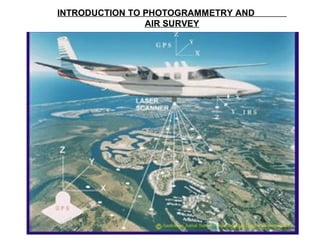
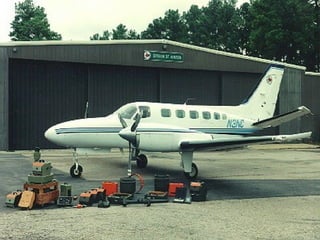
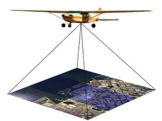
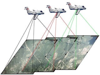
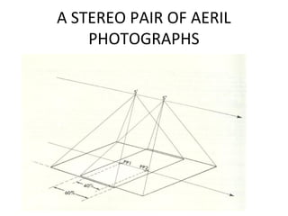
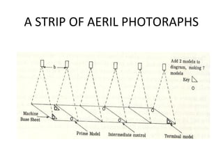
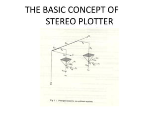
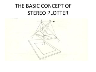
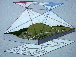
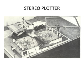
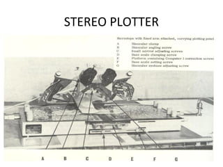
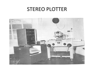
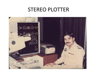
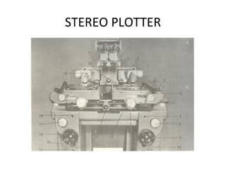
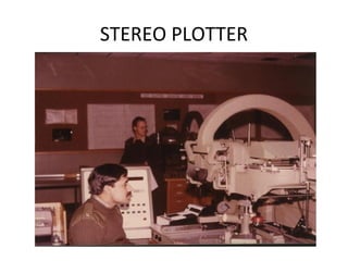
Photogrammetry is the science of obtaining reliable measurements from photographs. There are three main techniques: aerial, using vertically downward photos from planes or satellites; terrestrial, using horizontal photos on the ground; and industrial, adapting terrestrial techniques to small areas. Aerial photos are used for topographic mapping, cadastral plans, land use maps, and hydrographic charts. Stereo plotters allow precise 3D measurement and analysis from stereo photo pairs. Photogrammetry has many applications beyond traditional surveying, including traffic accident reconstruction, medical imaging, and analysis of surface movement.
Aerial surveying technology is utilized in a wide range of fields throughout the world. These range from the creation of maps, to terrain analysis and research (rivers, soil erosion, coasts, etc.), urban planning, road planning (roads, rails, etc.), and vegetation research (forests, agriculture, lakes and marshland, etc.).
This document help you to prepare Triangulation Network (TIN), Hillshade Map, Slope map, interpolation and Digital Elevation Model (DEM) in a area and how to interpret them.
Photogrammetry Surveying, its Benefits & DrawbacksNI BT
Learn the Photogrammetry Surveying and benefits-drawbacks of photogrammetry. Photogrammetry is the process of generating a 3D model from a set of 2D photographs. In Surveying, this is done by taking two or more images of the same point from different angles
This presentation about photogrammetry survey, this presentation gives a complete detail of photogrammetry survey. Photogrammetry survey is a powerful technique used in various industries to obtain accurate measurements and three-dimensional (3D) data from photographs. It involves the process of extracting precise geometric information from images using specialized software, providing a cost-effective and efficient method for capturing and analysing spatial data.
Epitome Geotechnical is a Geo survey Mapping company in India. Our services are Drone Survey and Aerial Photography Survey Services in India.
visit: www.epitomegs.com
In the vast realm of surveying techniques, Epitome provide drone aerial photography survey have emerged as a transformative technology, offering a unique perspective from the sky. This article delves into the evolution, applications, and future trends of drone aerial photography survey, unraveling the myriad advantages and challenges associated with this cutting-edge approach. Drone surveys have revolutionized the field of data collection, offering a nimble and efficient alternative to traditional survey methods. These unmanned aerial vehicles, equipped with advanced sensors and cameras, enable the rapid and cost-effective acquisition of high-resolution imagery and geospatial data.
The Three Step Writing Process (Technical & Business Writing)Waleed Liaqat
Explains the three step writing process that needs to be followed while preparing letters, applications, brochures etc. Indirect and Direct approach in writing are also explained.
Verses about the Quran
Verses about Allah (God)
Verses about the Creation
Verses about the Prophets & Messengers
Verses about Jesus Christ (peace be upon him)
Verses about the Prophet Muhammad (peace be upon him),
Verses about the Religion
Verses about the Noble Traits of the Believers
Verses about the Life of this world
Verses about the Resurrection
Verses about Death
Verses about the Day of Judgment
Verses about the Hereafter
An Admonition to Humanity
Construction machinery - Associated costs and basic conceptsWaleed Liaqat
The presentation contains information regarding the costs associated with operation and maintenance of construction machinery along with some basic concepts pertinent to operation of the machinery.
Fundamentals of Effective Business CommunicationWaleed Liaqat
The presentation describes how to communicate effectively in the business world today. Content has been extracted from "Business Communication Today" (9 ed.)
LEED 2009 applied to a mixed - use buildingWaleed Liaqat
LEED 2009 applied to a mixed use building
This is just an example and many sustainability features suggested do not necessarily conform to LEED prerequisites ( a requirement for certification).
An Overview of the History of Pakistan: 1947 - 1973 Waleed Liaqat
Describes early problems faced by Pakistan as an independent state.
Major events between 1947 and 1973 are given in a timeline. Foreign relations between Pakistan and power states such as China,Former USSR and US are also described.
General concepts such as workability, aggregate properties, problems with concrete components, admixtures
Note:- The information contained in the document may be incomplete i.e. it may not cover each topic in its entirety
Epistemic Interaction - tuning interfaces to provide information for AI supportAlan Dix
Paper presented at SYNERGY workshop at AVI 2024, Genoa, Italy. 3rd June 2024
https://alandix.com/academic/papers/synergy2024-epistemic/
As machine learning integrates deeper into human-computer interactions, the concept of epistemic interaction emerges, aiming to refine these interactions to enhance system adaptability. This approach encourages minor, intentional adjustments in user behaviour to enrich the data available for system learning. This paper introduces epistemic interaction within the context of human-system communication, illustrating how deliberate interaction design can improve system understanding and adaptation. Through concrete examples, we demonstrate the potential of epistemic interaction to significantly advance human-computer interaction by leveraging intuitive human communication strategies to inform system design and functionality, offering a novel pathway for enriching user-system engagements.
Essentials of Automations: Optimizing FME Workflows with ParametersSafe Software
Are you looking to streamline your workflows and boost your projects’ efficiency? Do you find yourself searching for ways to add flexibility and control over your FME workflows? If so, you’re in the right place.
Join us for an insightful dive into the world of FME parameters, a critical element in optimizing workflow efficiency. This webinar marks the beginning of our three-part “Essentials of Automation” series. This first webinar is designed to equip you with the knowledge and skills to utilize parameters effectively: enhancing the flexibility, maintainability, and user control of your FME projects.
Here’s what you’ll gain:
- Essentials of FME Parameters: Understand the pivotal role of parameters, including Reader/Writer, Transformer, User, and FME Flow categories. Discover how they are the key to unlocking automation and optimization within your workflows.
- Practical Applications in FME Form: Delve into key user parameter types including choice, connections, and file URLs. Allow users to control how a workflow runs, making your workflows more reusable. Learn to import values and deliver the best user experience for your workflows while enhancing accuracy.
- Optimization Strategies in FME Flow: Explore the creation and strategic deployment of parameters in FME Flow, including the use of deployment and geometry parameters, to maximize workflow efficiency.
- Pro Tips for Success: Gain insights on parameterizing connections and leveraging new features like Conditional Visibility for clarity and simplicity.
We’ll wrap up with a glimpse into future webinars, followed by a Q&A session to address your specific questions surrounding this topic.
Don’t miss this opportunity to elevate your FME expertise and drive your projects to new heights of efficiency.
UiPath Test Automation using UiPath Test Suite series, part 3DianaGray10
Welcome to UiPath Test Automation using UiPath Test Suite series part 3. In this session, we will cover desktop automation along with UI automation.
Topics covered:
UI automation Introduction,
UI automation Sample
Desktop automation flow
Pradeep Chinnala, Senior Consultant Automation Developer @WonderBotz and UiPath MVP
Deepak Rai, Automation Practice Lead, Boundaryless Group and UiPath MVP
Elevating Tactical DDD Patterns Through Object CalisthenicsDorra BARTAGUIZ
After immersing yourself in the blue book and its red counterpart, attending DDD-focused conferences, and applying tactical patterns, you're left with a crucial question: How do I ensure my design is effective? Tactical patterns within Domain-Driven Design (DDD) serve as guiding principles for creating clear and manageable domain models. However, achieving success with these patterns requires additional guidance. Interestingly, we've observed that a set of constraints initially designed for training purposes remarkably aligns with effective pattern implementation, offering a more ‘mechanical’ approach. Let's explore together how Object Calisthenics can elevate the design of your tactical DDD patterns, offering concrete help for those venturing into DDD for the first time!
Accelerate your Kubernetes clusters with Varnish CachingThijs Feryn
A presentation about the usage and availability of Varnish on Kubernetes. This talk explores the capabilities of Varnish caching and shows how to use the Varnish Helm chart to deploy it to Kubernetes.
This presentation was delivered at K8SUG Singapore. See https://feryn.eu/presentations/accelerate-your-kubernetes-clusters-with-varnish-caching-k8sug-singapore-28-2024 for more details.
JMeter webinar - integration with InfluxDB and GrafanaRTTS
Watch this recorded webinar about real-time monitoring of application performance. See how to integrate Apache JMeter, the open-source leader in performance testing, with InfluxDB, the open-source time-series database, and Grafana, the open-source analytics and visualization application.
In this webinar, we will review the benefits of leveraging InfluxDB and Grafana when executing load tests and demonstrate how these tools are used to visualize performance metrics.
Length: 30 minutes
Session Overview
-------------------------------------------
During this webinar, we will cover the following topics while demonstrating the integrations of JMeter, InfluxDB and Grafana:
- What out-of-the-box solutions are available for real-time monitoring JMeter tests?
- What are the benefits of integrating InfluxDB and Grafana into the load testing stack?
- Which features are provided by Grafana?
- Demonstration of InfluxDB and Grafana using a practice web application
To view the webinar recording, go to:
https://www.rttsweb.com/jmeter-integration-webinar
Generating a custom Ruby SDK for your web service or Rails API using Smithyg2nightmarescribd
Have you ever wanted a Ruby client API to communicate with your web service? Smithy is a protocol-agnostic language for defining services and SDKs. Smithy Ruby is an implementation of Smithy that generates a Ruby SDK using a Smithy model. In this talk, we will explore Smithy and Smithy Ruby to learn how to generate custom feature-rich SDKs that can communicate with any web service, such as a Rails JSON API.
DevOps and Testing slides at DASA ConnectKari Kakkonen
My and Rik Marselis slides at 30.5.2024 DASA Connect conference. We discuss about what is testing, then what is agile testing and finally what is Testing in DevOps. Finally we had lovely workshop with the participants trying to find out different ways to think about quality and testing in different parts of the DevOps infinity loop.
Kubernetes & AI - Beauty and the Beast !?! @KCD Istanbul 2024Tobias Schneck
As AI technology is pushing into IT I was wondering myself, as an “infrastructure container kubernetes guy”, how get this fancy AI technology get managed from an infrastructure operational view? Is it possible to apply our lovely cloud native principals as well? What benefit’s both technologies could bring to each other?
Let me take this questions and provide you a short journey through existing deployment models and use cases for AI software. On practical examples, we discuss what cloud/on-premise strategy we may need for applying it to our own infrastructure to get it to work from an enterprise perspective. I want to give an overview about infrastructure requirements and technologies, what could be beneficial or limiting your AI use cases in an enterprise environment. An interactive Demo will give you some insides, what approaches I got already working for real.
3. DEFINITION
• Photogrammetry is defined as the science of
obtaining reliable measurements, by the use
of photographs, in order to determine
characteristics such as size, shape and position
of photographed objects
24. SURVEY APPLICATIONS OF
PHOTOGRAMMETRY
a. Topographical Mapping
– The plotting of map detail and contours is normally
carried out using aerial photogrammetric methods
– These methods are used for both original survey and
revision, and replace classical ground methods
except where the task is so small that flying is
uneconomical
– The technique needs a certain amount of ground
surveyed control, but this requirement is being
continually reduced with the improvement of aerial
triangulation techniques to provide supplementary
control.
– A final Field check is necessary
25. SURVEY APPLICATIONS OF
PHOTOGRAMMETRY
b. Large Scale Plans
– Large scale surveys can be produced accurately and
quickly by air survey methods, but require more field
checking in addition to the provision of ground
control
– For large tasks, such as road building and major
constructions, air survey methods are quicker and
cheaper than ground methods
– Profiles for determination of earthwork quantities
and other data useful to Civil Engineer may be
simply obtained from the same photographs
26. SURVEY APPLICATIONS OF
PHOTOGRAMMETRY
c. Cadastral Plans
– Similar advantages may be gained by an air survey for
cadastral purpose as are provided in the production
of large scale plans.
– As the accuracy of the cadastral plan is related to the
value of land, the traditional ground method trends to
be slower, costly but very accurate
– In most cases, the accuracy of a well planned air
survey is sufficient for cadastral purposes, and this
method is used in many countries
– Where boundaries are related to described features,
or land is very valuable, the additional accuracy of
ground survey may be necessary
27. SURVEY APPLICATIONS OF
PHOTOGRAMMETRY
d. Land use maps
– Air survey techniques may be used not only to
define the extent of an area, but also to identify
its use and measure the yield of a crop
– Forestry is a typical application where, by plotting
the limits of timber and measuring tree heights,
an accurate estimate of yield may be given.
– The use of special films, such as color and infra-
red will provide additional information about the
quality of the crop
28. SURVEY APPLICATIONS OF
PHOTOGRAMMETRY
e. Hydrographic Maps and Charts
– Air survey techniques are particularly valuable in
the accurate plotting of coastlines, sandbanks and
small islands where the changing tide is a problem
for ground methods
– The use of special film will again add more
information, either by clearly delineating water
limits or by extra penetration in shallow water
29. SURVEY APPLICATIONS OF
PHOTOGRAMMETRY
f. Exploration and Reconnaissance
– Information may be gained about areas to which
access is restricted by employing air survey
techniques
– In the case of military reconnaissance, a high flying or
unmanned aircraft can obtain photograph that will
provide data for an accurate survey
– For explorers, and area can be mapped before the
first entry, either from photographs obtained by
aircraft as in the case of Moon or Mars, or by specially
equiped satellites
30. SURVEY APPLICATIONS OF
PHOTOGRAMMETRY
g. Terrestrial, Industrial and Scientific Uses
– Photogrammetry has provided rapid, accurate and
in some cases unique solutions to many non
topographical problems.
– The following are of particular interest
1.Detailed Survey of Historic Buildings
– Precise plans of building facades and architectural
detail may be obtained without direct
measurement by terrestrial photogrammetric
techniques
31. TERRESTRIAL, INDUSTRIAL AND
SCIENTIFIC USES
2. Traffic Accidents
– Terrestrial methods are also used to record details
of accidents in some countries
– This allows obstructions to be cleared without
delay, the scene being plotted at a later stage
3. Medical Applications
– Short range photogrammetry is in use by doctors
and dentists to define conditions requiring
treatment and also to study the results of
treatment
32. TERRESTRIAL, INDUSTRIAL AND
SCIENTIFIC USES
4. Analysis of movement
– Tidal and Particle movement may be analyzed by
photogrammetric methods by taking photographs
of the moving surface with a fixed camera
– The stereo model obtained shows vertical “relief”
proportional to the amount of movement
“contours” may be plotted