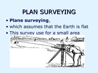
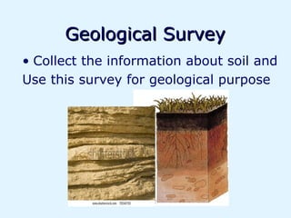
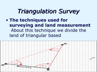
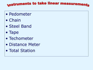
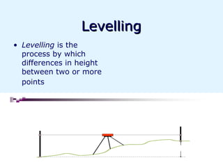
Engineering is the application of scientific and economic principles to design and build machines, structures, and other items, including bridges, roads, vehicles, and buildings. Civil engineering deals specifically with designing and constructing physical and natural built environments like roads, buildings, airports, tunnels, dams, and bridges. A survey is used to collect information about natural and man-made features of an area using various instruments, and has applications in areas like construction, geology, archaeology, and more. Modern surveying instruments have become more advanced with technologies like total stations, GPS, levels, theodolites, distance meters, and more that improve accuracy of data collection.
in this section the study of the various classification of the surveying. which based the surveying is classified and how many types of the surveying? all this is presented in this slide.
and that slide how it work?
in this section the study of the various classification of the surveying. which based the surveying is classified and how many types of the surveying? all this is presented in this slide.
and that slide how it work?
Introduction to surveying, ranging and chainingShital Navghare
This presentation contains the complete introduction of surveying. It also includes all the instrucments used in linear measurement and the terms related to Ranging and Chaining
This ppt presentation covers compass surveying, which explains principal of compass surveying, Types of compass, Difference between compass, Bearing, Definitions related to compass surveying etc.
Metric Chain : It Consists of galvanized mild steel wire of 4mm diameter known as link.
It is available in 20m, 30m, 50m length which consists of 100 links.
Gunter’s Chain : A 66 feet long chain consists of 100 links, each of 0.66 feet, it is known as Gunter’s chain.
This chain is suitable for taking length in miles.
Engineer’s Chain : A 100 feet long chain consisting of 100 links each of 1 feet is known as engineer’s chain.
This chain is used to measure length in feet and area in sq.yard.
Revenue Chain : it is 33 feet long chain consisting of 16 links.
This chain is used for distance measurements in feet & inches for smaller areas.
Plane Table Surveying is a graphical method of survey in which the field observations and plotting are done simultaneously.
It is simple and cheaper than theodolite survey. It is most suitable for small scale maps.
The plan is drawn by the surveyor in the field, while the area to be surveyed is before his eyes. Therefore, there is no possibility of omitting the necessary measurements.
Conventional and modern surveying instrumentssameedaslam
Instruments have a major importance in the field of survey. There are numerous instruments which are used in surveying.With the passage of time instruments have been modified and more accurate.
The science of today is the technology of tomorrow.
Distance Measurement & Chain Surveying
Contents
• Introduction About Surveying
.
• Primary Division Of Surveying • Classification Of Surveying • Distance Measurement And Chain Surveying • Principle Of Surveying • Types Of Tapes Based On The Materials Used • Erecting And Dropping A Perpendicular • Obstacle In Chain Survey • Types Of Errors • Corrections of Tape • Off –Sets • Ranging • Conclusion . • Homework And Next Lecture . • References.
-Definition of Surveying.
Types of Surveying
1. Plane Surveying
2. Geodetic Survey
3. Cadastral surveying
4. Aerial Surveying
5. Hydro graphic Surveying (Hydro-Survey)
6. Topographical Survey
7. Engineering Survey.
Primary division of Surveying
Reconnaissance.
• This is preliminary survey of the land to be surveyed. It may be either
1-Ground reconnaissance 2- Aerial reconnaissance survey.
Objectives of Reconnaissance
1. To ascertain the possibility of building or constructing route or track through the area.
Classification of Surveying:
1- Classification based on the instruments used:
A. Chain Surveying.
B. Compass Surveying.
C. Theodolite Surveying.
D. Tachometric Surveying .
E. Trigonometric Surveying.
F. Total station and GPS.
G. Photogrammetric and Aerial Surveying.
H. Plan Table .
2- According to the method used:
i. Traversing .
ii. Triangulation .
iii. Tacheometric.
iv. Trigonometric.
3- According to the Purpose of surveying:
i. Engineering survey.
ii. Military survey.
iii. Geological survey .
iv. Topographical survey
Chain and Tape Survey
-Length& Distance Measurements.
-Distance Measurement and Chain Surveying.
• In general there are two methods:
1- Direct methods of measuring lengths
2- Indirect methods of measuring distances.
There are two kinds of measurements used in plane surveying.
*Linear measurements
*Angular measurements
-Instruments used in Chain Surveying.
Types of tapes based on the materials used.
.......
.
.
.
.
.
.
.
.
.
.
Asst. Prof. Salar K.Hussein
Mr. Kamal Y.Abdullah
Asst.Lecturer. Dilveen H. Omar
Erbil Polytechnic University
Technical Engineering College
Civil Engineering Department
Surveying and scale_Surveying, Civil EngineeringA Makwana
It is defined as the process of measuring horizontal distances, vertical distances and included angles to determine the location of points on, above or below the earth surfaces.
The term surveying is the representation of surface features in a horizontal plane.
The process of determining the relative heights in the vertical plane is referred as levelling.
What is a Total Station?
Capability of a Total Station
Important Operations of Total Station
Uses of Total Station
Advantages of Using Total Stations
Applications
Between Filth and Fortune- Urban Cattle Foraging Realities by Devi S Nair, An...Mansi Shah
This study examines cattle rearing in urban and rural settings, focusing on milk production and consumption. By exploring a case in Ahmedabad, it highlights the challenges and processes in dairy farming across different environments, emphasising the need for sustainable practices and the essential role of milk in daily consumption.
Transforming Brand Perception and Boosting Profitabilityaaryangarg12
In today's digital era, the dynamics of brand perception, consumer behavior, and profitability have been profoundly reshaped by the synergy of branding, social media, and website design. This research paper investigates the transformative power of these elements in influencing how individuals perceive brands and products and how this transformation can be harnessed to drive sales and profitability for businesses.
Through an exploration of brand psychology and consumer behavior, this study sheds light on the intricate ways in which effective branding strategies, strategic social media engagement, and user-centric website design contribute to altering consumers' perceptions. We delve into the principles that underlie successful brand transformations, examining how visual identity, messaging, and storytelling can captivate and resonate with target audiences.
Methodologically, this research employs a comprehensive approach, combining qualitative and quantitative analyses. Real-world case studies illustrate the impact of branding, social media campaigns, and website redesigns on consumer perception, sales figures, and profitability. We assess the various metrics, including brand awareness, customer engagement, conversion rates, and revenue growth, to measure the effectiveness of these strategies.
The results underscore the pivotal role of cohesive branding, social media influence, and website usability in shaping positive brand perceptions, influencing consumer decisions, and ultimately bolstering sales and profitability. This paper provides actionable insights and strategic recommendations for businesses seeking to leverage branding, social media, and website design as potent tools to enhance their market position and financial success.
Hello everyone! I am thrilled to present my latest portfolio on LinkedIn, marking the culmination of my architectural journey thus far. Over the span of five years, I've been fortunate to acquire a wealth of knowledge under the guidance of esteemed professors and industry mentors. From rigorous academic pursuits to practical engagements, each experience has contributed to my growth and refinement as an architecture student. This portfolio not only showcases my projects but also underscores my attention to detail and to innovative architecture as a profession.
Expert Accessory Dwelling Unit (ADU) Drafting ServicesResDraft
Whether you’re looking to create a guest house, a rental unit, or a private retreat, our experienced team will design a space that complements your existing home and maximizes your investment. We provide personalized, comprehensive expert accessory dwelling unit (ADU)drafting solutions tailored to your needs, ensuring a seamless process from concept to completion.
4. “Life is like riding a bicycle, To keep your balance,
you must keep moving.”
-Albert Einstein
5.
6. Engineering
• A creative process
• Engineering is the art of applying scientific, social and
economic principles to create machines, buildings, devices
7. Allah is biggest creater
Works with Nature, Not Against It
Nature Often Guides us how to solve this
problem..
8. Civil Engineering
• Civil Engineering is one of the oldest and most widely recognized
engineering disciplines that deals with the design,construction,and
maintenance
9. Engineer
• Who apply his Knowledge of Science,
Mathematics and Economics to
Develop Useful Devices, Structures
and Processes.
47. Auto level
• Auto-Level is a Professional
Leveling Tool used by
Contractors, Builders, Land
Surveying Professionals, or
the Engineer who demands
accurate leveling ..
51. Electronic Distance
Meter(edm)
• A very accurate
method of measuring
distance by means of
an electronic device.
Most EDM instruments
are operated by infra-
red light or laser, with
the beam being
directed at a target
which may be some
kilometres away, and
give a direct reading
with an accuracy of 1
in 10000 or better
52. GPS
• Global Positioning
System
• The Global Positioning
System (GPS) is a
worldwide radio-
navigation system
formed from a
constellation of 24
satellites and their
ground stations. GPS
uses .
53. AQUEDUCT in the West of Belgium. This concrete structure has
498 meters long and 46 meters wide. Weight 65,000 tons and is
supported by 28 one meters in diameter concrete columns.