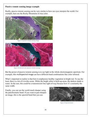
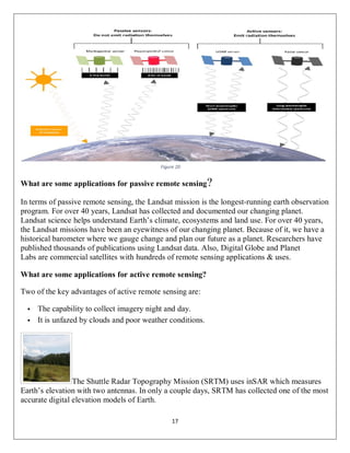
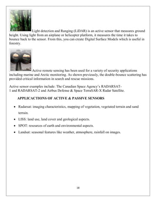
SlideShare a Scribd company logo
(passive and active remote sensing systems,
characteristics and operations)
Student Name: Copyright
Class: 4th Stage
Course Title: remote sensing
Department: Geomatics Department
College of Engineering
Salahaddin University-Erbil
Academic Year 2019-2020
1
ABSTRACT
The development of remote sensing technologies increases the potential to support more
precise, efficient, and ecologically-sensitive approaches to forest resource management. One of
the primary requirements of precision forest management is accurate and detailed 3D spatial
data relating to the type and condition of forest stands and characteristics of the underlying
terrain surface. A new generation of high-resolution, active remote sensing technologies,
including airborne laser scanning (LIDAR) and interferometric synthetic aperture RADAR
(IFSAR) have the capability to provide direct, 3D measurements of forest canopy structure and
topography. remote sensing is the process of detecting and monitoring the physical
characteristics of an area by measuring its reflected and emitted radiation at a distance (typically
from satellite or aircraft). Special cameras collect remotely sensed images, which help
researchers "sense" things about the Earth. The sun provides a very convenient source of energy
for remote sensing. The sun's energy is either reflected, as it is for visible wavelengths, or
absorbed and then re-emitted, as it is for thermal infrared wavelengths. Remote sensing systems
which measure energy that is naturally available are called passive sensors. Passive sensors can
only be used to detect energy when the naturally occurring energy is available. For all reflected
energy, this can only take place during the time when the sun is illuminating the Earth. There is
no reflected energy available from the sun at night. Energy that is naturally emitted (such as
thermal infrared) can be detected day or night, as long as the amount of energy is large enough
to be recorded. Active sensors, on the other hand, provide their own energy source for
illumination. The sensor emits radiation which is directed toward the target to be investigated.
The radiation reflected from that target is detected and measured by the sensor. Active sensors
can be used for examining wavelengths that are not sufficiently provided by the sun, such as
microwaves, or to better control the way a target is illuminated. However, active systems
require the generation of a fairly large amount of energy to adequately illuminate targets.
2
Table of content
ABSTRACT ............................................................................................................................. 1
Table of content........................................................................................................................ 2
INTRODUCTION ................................................................................................................... 3
BACKGROUND...................................................................................................................... 5
METHOD................................................................................................................................10
THEORY.................................................................................................................................13
Conclusion...............................................................................................................................19
REFRENCE ............................................................................................................................19
3
INTRODUCTION
Remote sensing instruments are of two primary types— active and passive. Active sensors,
provide their own source of energy to illuminate the objects they observe. An active sensor
emits radiation in the direction of the target to be investigated. The sensor then detects and
measures the radiation that is reflected or backscattered from the target. Passive sensors, on the
other hand, detect natural energy (radiation) that is emitted or reflected by the object or scene
being observed. Reflected sunlight is the most common source of radiation measured by passive
sensors. A passive sensor is a device that detects and responds to some type of input from the
physical environment.
Passive sensor technologies gather target data through the detection of vibrations, light,
radiation, heat or other phenomena occurring in the subject’s environment. They contrast with
active sensors, which include transmitters that send out a signal, a light wavelength or electrons
to be bounced off the target, with data gathered by the sensor upon their reflection. Both active
and passive sensing technologies are often used to make observations and measurements from a
distance or on a scale beyond those observable to the naked eye. Sensors can also be used in
harsh environments and places inaccessible to people. Examples of passive sensor-based
technologies include: Photographic, thermal, electric field sensing, chemical, infrared and
seismic. However, as can be the case with some sensors, seismic and infrared light sensors exist
in both active and passive forms. Depending on what is being sensed these various sensors
might be mounted to a satellite, airplane, boat, submarine UAV drone, or from another
convenient point of observation such as a building top. The data gathered by remote sensing is
used for everything from cartography to resource exploration to atmospheric and chemical
measurements. Remote sensing is also one of the basic enabling technologies for the Internet of
Things (IoT), in which almost any imaginable entity can be equipped with a unique identifier
and the ability to transfer data over a network autonomously. Both types of sensors have
benefits and drawbacks. Passive sensor technologies can't be detected by observed parties as
they only sense what is in the environment rather than relying on a transmitter whose activity
4
might be detected with equipment. Active sensors, however, can sometimes be used when
passive sources of observations by sensor are impossible. Passive sensors include different
types of radiometers and spectrometers.
An active sensor is a radar instrument used for measuring signals transmitted by the sensor that
were reflected, refracted or scattered by the Earth's surface or its atmosphere. Spaceborne active
sensors have a variety of applications related to meteorology and observation of the Earth's
surface and atmosphere. For example, precipitation radars measure the radar echo from rainfall
to determine the rainfall rate over the Earth's surface; and cloud profile radars measure the radar
echo return from clouds to provide a three dimensional profile of cloud reflectivity over the
Earth's surface. Spaceborne active sensors operate in the Earth Exploration-Satellite Service or
in the Space Research Service. Active sensor frequency allocations are often shared with other
radar systems, as such systems are normally compatible with the operation of the sensors.
5
BACKGROUND
Most passive systems used in remote sensing applications operate in the visible, infrared,
thermal infrared, and microwave portions of the electromagnetic spectrum. Passive remote
sensors include the following:
 Accelerometer—An instrument that measures acceleration (change in velocity per unit
time). There are two general types of accelerometers. One measures translational
accelerations (changes in linear motions in one or more dimensions), and the other
measures angular accelerations (changes in rotation rate per unit time).
 Hyperspectral radiometer—An advanced multispectral sensor that detects hundreds of
very narrow spectral bands throughout the visible, near-infrared, and mid-infrared
portions of the electromagnetic spectrum. This sensor’s very high spectral resolution
facilitates fine discrimination between different targets based on their spectral response in
each of the narrow bands.
Figure 1 accelerometer
Figure 2 hyperspectral
6
 Imaging radiometer—A radiometer that has a scanning capability to provide a two-
dimensional array of pixels from which an image may be produced. Scanning can be
performed mechanically or electronically by using an array of detectors.
 Radiometer—An instrument that quantitatively measures the intensity of
electromagnetic radiation in some bands within the spectrum. Usually, a radiometer is
further identified by the portion of the spectrum it covers; for example, visible, infrared,
or microwave.
 Sounder—An instrument that measures vertical distributions of atmospheric parameters
such as temperature, pressure, and composition from multispectral information.
Figure 5 atmospheric instrument sounder
Figure 4 infrared radiometer
Figure 3 imaging radiometer
7
 Spectrometer—A device that is designed to detect, measure, and analyze the spectral
content of incident electromagnetic radiation. Conventional imaging spectrometers use
gratings or prisms to disperse the radiation for spectral discrimination.
 Spectroradiometer—A radiometer that measures the intensity of radiation in multiple
wavelength bands (i.e., multispectral). Many times the bands are of high-spectral
resolution, designed for remotely sensing specific geophysical parameters
The majority of active sensors operate in the microwave portion of the electromagnetic
spectrum, which makes them able to penetrate the atmosphere under most conditions. An active
technique views the target from either end of a baseline of known length. The change in
apparent view direction (parallax) is related to the absolute distance between the instrument and
target.
Figure 6 spectrometer
Figure 7 spectroradiometer-DTS140- instrument system
8
 Laser altimeter—An instrument that uses LIDAR to measure the height of the platform
(spacecraft or aircraft) above the surface. The height of the platform with respect to the
mean Earth’s surface is used to determine the topography of the underlying surface.
 LIDAR—A light detection and ranging sensor that uses a laser (light amplification by
stimulated emission of radiation) radar to transmit a light pulse and a receiver with
sensitive detectors to measure the backscattered or reflected light. Distance to the object
is determined by recording the time between transmitted and backscattered pulses and by
using the speed of light to calculate the distance traveled.
Figure 8 laser altimeter
Figure 9 lider remote sensing
9
 Radar—An active radio detection and ranging sensor that
provides its own source of electromagnetic energy. An active
radar sensor, whether airborne or space borne, emits
microwave radiation in a series of pulses from an antenna.
When the energy reaches the target, some of the energy is
reflected back toward the sensor. This backscattered
microwave radiation is detected, measured, and timed. The time
required for the energy to travel to the target and return back to the sensor determines the
distance or range to the target. By recording the range and magnitude of the energy
reflected from all targets as the system passes by, a two-dimensional image of the surface
can be produced.
 Ranging Instrument—A device that measures the distance between the instrument and a
target object. Radars and altimeters work by determining the time a transmitted pulse
(microwaves or light) takes to reflect from a target and return to the instrument. Another
technique employs identical microwave instruments on a pair of platforms. Signals are
transmitted from each instrument to the other, with the distance between the two
determined from the difference between the received signal phase and transmitted
(reference) phase. These are examples of active techniques. An active technique views
the target from either end of a baseline of known length. The change in apparent view
direction (parallax) is related to the absolute distance between the instrument and target.
 Scatterometer—A high-frequency microwave radar designed specifically to measure
backscattered radiation. Over ocean surfaces,
measurements of backscattered radiation in the
microwave spectral region can be used to derive
maps of surface wind speed and direction.
Figure 10 radar
Figure 11 scatterometer
10
METHOD
Comparing active and passive microwave sensors
Passive microwave remote sensing Active microwave remote sensing
Sensor examples
AMSU-A & -B, MHS, ATMS, NPOESS. Jason-1and 2, Envisat ASAR, RA-2,
RADARSAT.
Measurement capabilities
Sense emitted microwave energy from
terrestrial sources.
Send and receive electromagnetic pulses of
energy.
Cloud and precipitations information
from layers.
Cloud and precipitation information from discrete
levels.
Sea surface wind vectors (WindSat,
MIS*), salinity.
Sea surface wind vectors, salinity.
Precipitations (rain rate and snowfall). Precipitation (rain rate and snowfall).
Cloud properties (microphysics, cloud top
and base).
Cloud properties (microphysics, cloud top, and
base).
Atmospheric temperature and moisture
profiling.
Snow and sea ice coverage and extent,
sea ice age.
Snow and sea ice coverage and extent, river ice
movement.
Snow cover characteristics Snow cover characteristics.
Soil moisture / surface wetness Soil moisture / surface wetness
Sea surface temperature Ocean surface topography, sea surface state, heat
storage and transfer (from radar altimeters).
Table 1
11
Advantages & disadvantages of active sensors
advantages disadvantages
Better control of noise sources
Through control of injected of signal.
because both of sources and receivers are under
the surveyor’s control, he must supply both.
Therefore, filed equipment tends to be more
complex.
Because propagating filed are generally
measured, active experiments usually provided
better depth control over source of anomalous
signal.
Field operations and logistics are generally
more complex and time consuming than passive
experiments.
Many different source/receiver configurations
can be used allowing for a wide variety of
survey designs. This allows survey designers
great flexibility in customizing surveys for
particular problems.
Many different source/receiver configurations
can be used allowing for a wide variety of
survey designs. The increase in the number of
field options inevitably leads to greater survey
design coasts and potentially to increased
probability of field
Once set up, active experiments are capable of
producing vast quantities of data that can be
used to interprets subtle details of the earth’s
subsurface.
The large quantity of data obtained in many
active experiments can become overwhelming
to process and interpret.
Table 2
12
Advantage & disadvantage of passive sensors
advantages Disadvantages
Surveyor need only record a naturally
occurring field; therefore, he need supply
only a sensor and a data recorder.
Less controls of noise because source of the
signal is out of the control of the surveyor.
Field operation are generally very time
officiant. Thus, passive experiments can be
run over wider areas in a more cost-effective
manner .
Because passive fields are generally the result
of integrating anomalous geologic
contributions over wide areas, identification
of the source of an anomalous reading can be
difficult.
One or two well-established field procedures
are generally used. Contractors can provide
these surveys on short notice with relatively
easily quantifiable results.
One or two well-established field procedures
is generally used. This limits the amount of
customization that can be done for specific
problems.
Interpretation of the limited set of
observations can be accomplished with
modest computational requirements quickly
and efficiently.
The data sets collected in passive experiments
are smaller than those collected in active
experiments and usually do not allow for as
detailed an interpretation.
Table 3
13
THEORY
Examples of passive and active remote sensing
Now that we have a clear understanding of passive and active remote sensing, let’s see it in action
for satellite sensors. In the schematic below, you can see how the sun emits light. First, light passes
through the atmospheric window. Then, it reflects off Earth to a satellite sensor orbiting Earth.
Figure 12 active remote sensing
Active Sensors
 An active sensor is a radar instrument used for measuring signals transmitted by the
sensor that were reflected, refracted or scattered by the Earth's surface or its
atmosphere.
 Spaceborne active sensors have a variety of applications related to meteorology and
observation of the Earth's surface and atmosphere.
 Examples of passive sensor-based technologies include: Photographic, thermal, electric
field sensing, chemical, infrared and seismic.
Active Sensor: Active sensor is used for sensing environment conditions and transmitted
signals. It is an electronic sensing device which requires AC and DC source for produce output.
Figure 13
14
Whereas active sensors illuminate their target. In this example, it’s a side-looking sensor that sends
its own pulse to Earth’s surface. First, it bounces off the ground. Then, it bounces again off a
building. Finally, it returns back to the sensor again. Actually, this type of backscatter is
called double bounce backscatter.
Figure 14 passive remote sensing
Passive sensor
 A passive sensor is a microwave instrument designed to receive and to measure natural
emissions produced by constituents of the Earth's surface and its atmosphere.
 The power measured by passive sensors is a function of the surface composition,
physical temperature, surface roughness, and other physical characteristics of the Earth.
 The frequency bands for passive sensor measurements are determined by fixed physical
properties (molecular resonance) of the substance being measured. These frequencies
do not change and information cannot be duplicated in other frequency bands.
 Examples of other active sensor-based technologies include: scanning electron
microscopes, LiDAR, radar, GPS, x-ray, sonar, infrared and seismic.
Figure 15
15
Active remote sensing image example If you ever have a chance to see a synthetic aperture
radar image, it will look speckled like this:
Figure 16 active remote sensing (radar image)
For the untrained eye, it’s just a bunch of black and white pixels. But the reality is that there’s more
that meets the eye. For example, the 3 main types of backscatter are:
 Specular reflection
 Double-bounce
 Diffuse scattering
SPECULAR REFLECTION: Specular reflection is where dark spots are in the image. In this
case, it’s the smooth surfaces like the east-west flowing river and paved surfaces.
DOUBLE-BOUNCE: The bright white in the center is double-bounce backscatter at work. As
shown in the schematic above, it’s an urban feature like a building but it’s not entirely clear at this
scale.
DIFFUSE SCATTERING: Finally, the majority of the radar image is rough surface and diffuse
scattering. This may be from the growing vegetation in the agriculture areas.
16
Passive remote sensing image example
Really, passive remote sensing can be very similar to how our eyes interpret the world. For
example, here are the Rocky Mountains in true color.
Figure 17 passive remote sensing image
But the power of passive remote sensing is to see light in the whole electromagnetic spectrum. For
example, this multispectral image can have different band combinations like color infrared.
What’s important to realize is that how it emphasizes healthy vegetation in bright red. To say the
least, there is a lot of it in this scene. While the bright white is built-up areas, the darkest shade is
water. In the east, this could be a transmission line right-of-way because how it’s constantly the
same width.
Finally, you can see the world much sharper using
the panchromatic band. If you want to pan-sharpen
an image, this is the spectral band that you use.
Figure 18 infrared color (passive remote sensing)
Figure 19 spectral band
17
What are some applications for passive remote sensing?
In terms of passive remote sensing, the Landsat mission is the longest-running earth observation
program. For over 40 years, Landsat has collected and documented our changing planet.
Landsat science helps understand Earth’s climate, ecosystems and land use. For over 40 years,
the Landsat missions have been an eyewitness of our changing planet. Because of it, we have a
historical barometer where we gauge change and plan our future as a planet. Researchers have
published thousands of publications using Landsat data. Also, Digital Globe and Planet
Labs are commercial satellites with hundreds of remote sensing applications & uses.
What are some applications for active remote sensing?
Two of the key advantages of active remote sensing are:
 The capability to collect imagery night and day.
 It is unfazed by clouds and poor weather conditions.
The Shuttle Radar Topography Mission (SRTM) uses inSAR which measures
Earth’s elevation with two antennas. In only a couple days, SRTM has collected one of the most
accurate digital elevation models of Earth.
Figure 20
18
Light detection and Ranging (LiDAR) is an active sensor that measures ground
height. Using light from an airplane or helicopter platform, it measures the time it takes to
bounce back to the sensor. From this, you can create Digital Surface Models which is useful in
forestry.
Active remote sensing has been used for a variety of security applications
including marine and Arctic monitoring. As shown previously, the double-bounce scattering has
provided critical information in search and rescue missions.
Active sensor examples include: The Canadian Space Agency’s RADARSAT-
1 and RADARSAT-2 and Airbus Defense & Space TerraSAR-X Radar Satellite.
APPLICACTIONS OF ACTIVE & PASSIVE SENSORS
 Radarsat: imaging characteristics, mapping of vegetation, vegetated terrain and sand
terrain.
 LISS: land use, land cover and geological aspects.
 SPOT: resources of earth and environmental aspects.
 Landsat: seasonal features like weather, atmosphere, rainfall on images.
19
Conclusion
 Sensor is a device comprising of optical component or system and a detector electronic
circuity used to record.
 It is a very important component in remote sensing.
 Active sensors are more advantageous than passive sensors.
 LISS is one of the active sensors which is launched in Indian satellites.
 LISS-2 is the advanced version carried by the Indian satellite IRS-1B.
REFRENCE
 Mani, A., & Co-requisites, P. BCE093-REMOTE SENSING AND GIS.
 Deal, Jeffrey T., and Wilson Greatbatch. "MRI-compatible medical device with passive
generation of optical sensing signals." U.S. Patent No. 6,711,440. 23 Mar. 2004..
 PREAMBLE, A., & PRE-REQUISITES, B. FUNDAMENTALS OF REMOTE
SENSING AND GIS..
 Cox, Helen, Kimberle Kelly, and Laura Yetter. "Using remote sensing and geospatial
technology for climate change education." Journal of Geoscience Education 62.4
(2014): 609-620..

More Related Content

What's hot

Atmospheric windows
Atmospheric windowsAtmospheric windows
Atmospheric windows
Sadia Rahat
 
Sensors
SensorsSensors
Remote sensing-presentaion
Remote sensing-presentaionRemote sensing-presentaion
Remote sensing-presentaion
Mouna Guru
 
Remote sensing and gis ppt
Remote sensing and gis pptRemote sensing and gis ppt
Remote sensing and gis ppt
preeti patil
 
Fundamentals of Remote Sensing
Fundamentals of Remote SensingFundamentals of Remote Sensing
Fundamentals of Remote Sensing
Shah Naseer
 
Remote Sensing Platforms and Its types
Remote Sensing Platforms and Its typesRemote Sensing Platforms and Its types
Remote Sensing Platforms and Its types
Senthamizhan M
 
Spectral reflectance curve of dead stressed vegetation
Spectral reflectance curve of dead stressed vegetationSpectral reflectance curve of dead stressed vegetation
Spectral reflectance curve of dead stressed vegetation
Junaid Ijaz
 
groundtruth collection for remotesensing support
groundtruth collection for remotesensing supportgroundtruth collection for remotesensing support
groundtruth collection for remotesensing support
Thiruvengadam .
 
Chapter 1 (Introduction to remote sensing)
Chapter 1 (Introduction to remote sensing)Chapter 1 (Introduction to remote sensing)
Chapter 1 (Introduction to remote sensing)
Shankar Gangaju
 
Thermal remote sensing
Thermal remote sensing   Thermal remote sensing
Thermal remote sensing
Rahat Malik
 
Remote sensing
 Remote sensing Remote sensing
Remote sensing
Fidy Zegge
 
Introduction to Remote Sensing
Introduction to Remote SensingIntroduction to Remote Sensing
Introduction to Remote Sensing
Malla Reddy University
 
Remote sensing
Remote sensingRemote sensing
Remote sensing
Kaium Chowdhury
 
Basic of Remote Sensing
Basic of Remote SensingBasic of Remote Sensing
Basic of Remote Sensing
gueste5cfed
 
Remote sensing - Scanners
Remote sensing - ScannersRemote sensing - Scanners
Remote sensing - Scanners
Pramoda Raj
 
Gps and its application
Gps and its applicationGps and its application
Gps and its application
shubham paliwal
 
Microwave remote sensing
Microwave remote sensingMicrowave remote sensing
Microwave remote sensing
Mohsin Siddique
 
Introduction to Landsat
Introduction to LandsatIntroduction to Landsat
Introduction to Landsat
Nizam GIS
 
datum
datumdatum
datum
Riya Gupta
 

What's hot (20)

Atmospheric windows
Atmospheric windowsAtmospheric windows
Atmospheric windows
 
Sensors
SensorsSensors
Sensors
 
Remote sensing-presentaion
Remote sensing-presentaionRemote sensing-presentaion
Remote sensing-presentaion
 
Remote sensing and gis ppt
Remote sensing and gis pptRemote sensing and gis ppt
Remote sensing and gis ppt
 
Fundamentals of Remote Sensing
Fundamentals of Remote SensingFundamentals of Remote Sensing
Fundamentals of Remote Sensing
 
Remote Sensing Platforms and Its types
Remote Sensing Platforms and Its typesRemote Sensing Platforms and Its types
Remote Sensing Platforms and Its types
 
Spectral reflectance curve of dead stressed vegetation
Spectral reflectance curve of dead stressed vegetationSpectral reflectance curve of dead stressed vegetation
Spectral reflectance curve of dead stressed vegetation
 
groundtruth collection for remotesensing support
groundtruth collection for remotesensing supportgroundtruth collection for remotesensing support
groundtruth collection for remotesensing support
 
Chapter 1 (Introduction to remote sensing)
Chapter 1 (Introduction to remote sensing)Chapter 1 (Introduction to remote sensing)
Chapter 1 (Introduction to remote sensing)
 
Thermal remote sensing
Thermal remote sensing   Thermal remote sensing
Thermal remote sensing
 
Remote sensing
 Remote sensing Remote sensing
Remote sensing
 
Introduction to Remote Sensing
Introduction to Remote SensingIntroduction to Remote Sensing
Introduction to Remote Sensing
 
Remote sensing
Remote sensingRemote sensing
Remote sensing
 
Basic of Remote Sensing
Basic of Remote SensingBasic of Remote Sensing
Basic of Remote Sensing
 
Remote sensing - Scanners
Remote sensing - ScannersRemote sensing - Scanners
Remote sensing - Scanners
 
Gps and its application
Gps and its applicationGps and its application
Gps and its application
 
Microwave remote sensing
Microwave remote sensingMicrowave remote sensing
Microwave remote sensing
 
Introduction to Landsat
Introduction to LandsatIntroduction to Landsat
Introduction to Landsat
 
remote sensing
remote sensingremote sensing
remote sensing
 
datum
datumdatum
datum
 

Similar to passive and active remote sensing systems, characteristics and operations

Remote sensing by Priyanshu kumar, 9608684800
Remote sensing by Priyanshu kumar, 9608684800Remote sensing by Priyanshu kumar, 9608684800
Remote sensing by Priyanshu kumar, 9608684800
PRIYANSHU KUMAR
 
Report
ReportReport
Report
ALIN BABU
 
Remote sensing
Remote sensingRemote sensing
Remote sensing
KHUSHBU SHAH
 
REMOTE SENSING
REMOTE SENSINGREMOTE SENSING
REMOTE SENSING
ijsrd.com
 
Remote Sensing: Meaning, Concept and Components | Geography
Remote Sensing: Meaning, Concept and Components | GeographyRemote Sensing: Meaning, Concept and Components | Geography
Remote Sensing: Meaning, Concept and Components | Geography
SrimantaKarak
 
Types of Remote Sensing.pdf
Types of Remote Sensing.pdfTypes of Remote Sensing.pdf
Types of Remote Sensing.pdf
UjjwalSubedi8
 
35001320006_Saraswati Mahato_Remote sensing and gis_ca 1_2024_even.pdf
35001320006_Saraswati Mahato_Remote sensing and gis_ca 1_2024_even.pdf35001320006_Saraswati Mahato_Remote sensing and gis_ca 1_2024_even.pdf
35001320006_Saraswati Mahato_Remote sensing and gis_ca 1_2024_even.pdf
barunmahato3
 
Remote sensing
Remote sensingRemote sensing
Remote sensing
Mohit Goyal
 
Ch 5 b remote sensing
Ch 5 b remote sensingCh 5 b remote sensing
rsgis-unitii-160731062950.pdf
rsgis-unitii-160731062950.pdfrsgis-unitii-160731062950.pdf
rsgis-unitii-160731062950.pdf
BSuresh26
 
G044044249
G044044249G044044249
G044044249
IJERA Editor
 
Kannan RS.ppt
Kannan RS.pptKannan RS.ppt
Kannan RS.ppt
DidhaaDirribaaHarmee
 
Remote sensing
Remote sensingRemote sensing
Remote sensing
Naresh Kumar
 
MAPPING REMOTE PLANTS THROUGH REMOTE SENSING TECHNOLOGY AND GIS
MAPPING REMOTE PLANTS THROUGH REMOTE SENSING TECHNOLOGY AND GISMAPPING REMOTE PLANTS THROUGH REMOTE SENSING TECHNOLOGY AND GIS
MAPPING REMOTE PLANTS THROUGH REMOTE SENSING TECHNOLOGY AND GIS
International Journal of Technical Research & Application
 
remote sensing for study.docx
remote sensing for study.docxremote sensing for study.docx
remote sensing for study.docx
bbc37142
 
Remote sensing
 Remote sensing Remote sensing
Basic Concepts of Remote Sensing
Basic Concepts of Remote Sensing Basic Concepts of Remote Sensing
Basic Concepts of Remote Sensing
Somenath Goswami
 
REMOTE SENSING........btech civil ..pptx
REMOTE SENSING........btech civil ..pptxREMOTE SENSING........btech civil ..pptx
REMOTE SENSING........btech civil ..pptx
Ayushsharma131736
 
Remote sensing
Remote sensingRemote sensing
Remote sensing
Anand Choudhary
 
Remote sensing by abhishek mahajan
Remote sensing by abhishek mahajanRemote sensing by abhishek mahajan
Remote sensing by abhishek mahajan
Abhishek Mahajan
 

Similar to passive and active remote sensing systems, characteristics and operations (20)

Remote sensing by Priyanshu kumar, 9608684800
Remote sensing by Priyanshu kumar, 9608684800Remote sensing by Priyanshu kumar, 9608684800
Remote sensing by Priyanshu kumar, 9608684800
 
Report
ReportReport
Report
 
Remote sensing
Remote sensingRemote sensing
Remote sensing
 
REMOTE SENSING
REMOTE SENSINGREMOTE SENSING
REMOTE SENSING
 
Remote Sensing: Meaning, Concept and Components | Geography
Remote Sensing: Meaning, Concept and Components | GeographyRemote Sensing: Meaning, Concept and Components | Geography
Remote Sensing: Meaning, Concept and Components | Geography
 
Types of Remote Sensing.pdf
Types of Remote Sensing.pdfTypes of Remote Sensing.pdf
Types of Remote Sensing.pdf
 
35001320006_Saraswati Mahato_Remote sensing and gis_ca 1_2024_even.pdf
35001320006_Saraswati Mahato_Remote sensing and gis_ca 1_2024_even.pdf35001320006_Saraswati Mahato_Remote sensing and gis_ca 1_2024_even.pdf
35001320006_Saraswati Mahato_Remote sensing and gis_ca 1_2024_even.pdf
 
Remote sensing
Remote sensingRemote sensing
Remote sensing
 
Ch 5 b remote sensing
Ch 5 b remote sensingCh 5 b remote sensing
Ch 5 b remote sensing
 
rsgis-unitii-160731062950.pdf
rsgis-unitii-160731062950.pdfrsgis-unitii-160731062950.pdf
rsgis-unitii-160731062950.pdf
 
G044044249
G044044249G044044249
G044044249
 
Kannan RS.ppt
Kannan RS.pptKannan RS.ppt
Kannan RS.ppt
 
Remote sensing
Remote sensingRemote sensing
Remote sensing
 
MAPPING REMOTE PLANTS THROUGH REMOTE SENSING TECHNOLOGY AND GIS
MAPPING REMOTE PLANTS THROUGH REMOTE SENSING TECHNOLOGY AND GISMAPPING REMOTE PLANTS THROUGH REMOTE SENSING TECHNOLOGY AND GIS
MAPPING REMOTE PLANTS THROUGH REMOTE SENSING TECHNOLOGY AND GIS
 
remote sensing for study.docx
remote sensing for study.docxremote sensing for study.docx
remote sensing for study.docx
 
Remote sensing
 Remote sensing Remote sensing
Remote sensing
 
Basic Concepts of Remote Sensing
Basic Concepts of Remote Sensing Basic Concepts of Remote Sensing
Basic Concepts of Remote Sensing
 
REMOTE SENSING........btech civil ..pptx
REMOTE SENSING........btech civil ..pptxREMOTE SENSING........btech civil ..pptx
REMOTE SENSING........btech civil ..pptx
 
Remote sensing
Remote sensingRemote sensing
Remote sensing
 
Remote sensing by abhishek mahajan
Remote sensing by abhishek mahajanRemote sensing by abhishek mahajan
Remote sensing by abhishek mahajan
 

More from Nzar Braim

Engineering Project Management
Engineering Project Management Engineering Project Management
Engineering Project Management
Nzar Braim
 
The Effect of Declination on The Tide Pattern in Hydroghraphic Surveying
The Effect of Declination on The Tide Pattern in Hydroghraphic SurveyingThe Effect of Declination on The Tide Pattern in Hydroghraphic Surveying
The Effect of Declination on The Tide Pattern in Hydroghraphic Surveying
Nzar Braim
 
Contribution Of Real Time Network (NRTK) for improvement of accuracy
Contribution Of Real Time Network (NRTK) for improvement of accuracyContribution Of Real Time Network (NRTK) for improvement of accuracy
Contribution Of Real Time Network (NRTK) for improvement of accuracy
Nzar Braim
 
Nominal & effective Interest Rates
Nominal & effective Interest RatesNominal & effective Interest Rates
Nominal & effective Interest Rates
Nzar Braim
 
Types of Walls (Brick,Concrete Block & Stone Walls)
Types of Walls (Brick,Concrete Block & Stone Walls)Types of Walls (Brick,Concrete Block & Stone Walls)
Types of Walls (Brick,Concrete Block & Stone Walls)
Nzar Braim
 
Comparing alternatives in Engineering Economics and Management
Comparing alternatives in Engineering Economics and ManagementComparing alternatives in Engineering Economics and Management
Comparing alternatives in Engineering Economics and Management
Nzar Braim
 
Differentiation between primary and secondary LIDAR system of Remote Sensing
Differentiation between primary and secondary LIDAR system of Remote SensingDifferentiation between primary and secondary LIDAR system of Remote Sensing
Differentiation between primary and secondary LIDAR system of Remote Sensing
Nzar Braim
 
The concept of total Horizontal and Vertical Uncertainty
The concept of total Horizontal and Vertical UncertaintyThe concept of total Horizontal and Vertical Uncertainty
The concept of total Horizontal and Vertical Uncertainty
Nzar Braim
 
Thermostone in Constrication or Thermostone
Thermostone in Constrication or ThermostoneThermostone in Constrication or Thermostone
Thermostone in Constrication or Thermostone
Nzar Braim
 
Developing project objectives and Execution plan in Economy management
Developing project objectives and Execution plan in Economy management Developing project objectives and Execution plan in Economy management
Developing project objectives and Execution plan in Economy management
Nzar Braim
 
Erbil Citadel - قةلَاي هةوليَر
Erbil Citadel - قةلَاي هةوليَرErbil Citadel - قةلَاي هةوليَر
Erbil Citadel - قةلَاي هةوليَر
Nzar Braim
 
SOIL STABILIZATION IN ROAD CONSTRUCTION AND MEASURING THE FIELD DENSITY [CO...
SOIL STABILIZATION IN ROAD CONSTRUCTION AND MEASURING  THE FIELD DENSITY  [CO...SOIL STABILIZATION IN ROAD CONSTRUCTION AND MEASURING  THE FIELD DENSITY  [CO...
SOIL STABILIZATION IN ROAD CONSTRUCTION AND MEASURING THE FIELD DENSITY [CO...
Nzar Braim
 
Law of supply and demand
Law of supply and demandLaw of supply and demand
Law of supply and demand
Nzar Braim
 
Role of electromagnetic Radiation in Remote Sensing
Role of electromagnetic Radiation in  Remote SensingRole of electromagnetic Radiation in  Remote Sensing
Role of electromagnetic Radiation in Remote Sensing
Nzar Braim
 
The Hyperbolic Radio System
The Hyperbolic Radio SystemThe Hyperbolic Radio System
The Hyperbolic Radio System
Nzar Braim
 
Car Parking Design in Urban Planning
Car Parking Design in Urban PlanningCar Parking Design in Urban Planning
Car Parking Design in Urban Planning
Nzar Braim
 
Portland cement in concrete
Portland cement  in concrete Portland cement  in concrete
Portland cement in concrete
Nzar Braim
 
Segregation in Concrete
Segregation in Concrete Segregation in Concrete
Segregation in Concrete
Nzar Braim
 
Bar Graph Method in Engineering management
Bar Graph Method in Engineering management Bar Graph Method in Engineering management
Bar Graph Method in Engineering management
Nzar Braim
 
Reconnaissance for Hydrographic Surveying Project
Reconnaissance for Hydrographic  Surveying ProjectReconnaissance for Hydrographic  Surveying Project
Reconnaissance for Hydrographic Surveying Project
Nzar Braim
 

More from Nzar Braim (20)

Engineering Project Management
Engineering Project Management Engineering Project Management
Engineering Project Management
 
The Effect of Declination on The Tide Pattern in Hydroghraphic Surveying
The Effect of Declination on The Tide Pattern in Hydroghraphic SurveyingThe Effect of Declination on The Tide Pattern in Hydroghraphic Surveying
The Effect of Declination on The Tide Pattern in Hydroghraphic Surveying
 
Contribution Of Real Time Network (NRTK) for improvement of accuracy
Contribution Of Real Time Network (NRTK) for improvement of accuracyContribution Of Real Time Network (NRTK) for improvement of accuracy
Contribution Of Real Time Network (NRTK) for improvement of accuracy
 
Nominal & effective Interest Rates
Nominal & effective Interest RatesNominal & effective Interest Rates
Nominal & effective Interest Rates
 
Types of Walls (Brick,Concrete Block & Stone Walls)
Types of Walls (Brick,Concrete Block & Stone Walls)Types of Walls (Brick,Concrete Block & Stone Walls)
Types of Walls (Brick,Concrete Block & Stone Walls)
 
Comparing alternatives in Engineering Economics and Management
Comparing alternatives in Engineering Economics and ManagementComparing alternatives in Engineering Economics and Management
Comparing alternatives in Engineering Economics and Management
 
Differentiation between primary and secondary LIDAR system of Remote Sensing
Differentiation between primary and secondary LIDAR system of Remote SensingDifferentiation between primary and secondary LIDAR system of Remote Sensing
Differentiation between primary and secondary LIDAR system of Remote Sensing
 
The concept of total Horizontal and Vertical Uncertainty
The concept of total Horizontal and Vertical UncertaintyThe concept of total Horizontal and Vertical Uncertainty
The concept of total Horizontal and Vertical Uncertainty
 
Thermostone in Constrication or Thermostone
Thermostone in Constrication or ThermostoneThermostone in Constrication or Thermostone
Thermostone in Constrication or Thermostone
 
Developing project objectives and Execution plan in Economy management
Developing project objectives and Execution plan in Economy management Developing project objectives and Execution plan in Economy management
Developing project objectives and Execution plan in Economy management
 
Erbil Citadel - قةلَاي هةوليَر
Erbil Citadel - قةلَاي هةوليَرErbil Citadel - قةلَاي هةوليَر
Erbil Citadel - قةلَاي هةوليَر
 
SOIL STABILIZATION IN ROAD CONSTRUCTION AND MEASURING THE FIELD DENSITY [CO...
SOIL STABILIZATION IN ROAD CONSTRUCTION AND MEASURING  THE FIELD DENSITY  [CO...SOIL STABILIZATION IN ROAD CONSTRUCTION AND MEASURING  THE FIELD DENSITY  [CO...
SOIL STABILIZATION IN ROAD CONSTRUCTION AND MEASURING THE FIELD DENSITY [CO...
 
Law of supply and demand
Law of supply and demandLaw of supply and demand
Law of supply and demand
 
Role of electromagnetic Radiation in Remote Sensing
Role of electromagnetic Radiation in  Remote SensingRole of electromagnetic Radiation in  Remote Sensing
Role of electromagnetic Radiation in Remote Sensing
 
The Hyperbolic Radio System
The Hyperbolic Radio SystemThe Hyperbolic Radio System
The Hyperbolic Radio System
 
Car Parking Design in Urban Planning
Car Parking Design in Urban PlanningCar Parking Design in Urban Planning
Car Parking Design in Urban Planning
 
Portland cement in concrete
Portland cement  in concrete Portland cement  in concrete
Portland cement in concrete
 
Segregation in Concrete
Segregation in Concrete Segregation in Concrete
Segregation in Concrete
 
Bar Graph Method in Engineering management
Bar Graph Method in Engineering management Bar Graph Method in Engineering management
Bar Graph Method in Engineering management
 
Reconnaissance for Hydrographic Surveying Project
Reconnaissance for Hydrographic  Surveying ProjectReconnaissance for Hydrographic  Surveying Project
Reconnaissance for Hydrographic Surveying Project
 

Recently uploaded

CME397 Surface Engineering- Professional Elective
CME397 Surface Engineering- Professional ElectiveCME397 Surface Engineering- Professional Elective
CME397 Surface Engineering- Professional Elective
karthi keyan
 
Student information management system project report ii.pdf
Student information management system project report ii.pdfStudent information management system project report ii.pdf
Student information management system project report ii.pdf
Kamal Acharya
 
ethical hacking-mobile hacking methods.ppt
ethical hacking-mobile hacking methods.pptethical hacking-mobile hacking methods.ppt
ethical hacking-mobile hacking methods.ppt
Jayaprasanna4
 
Halogenation process of chemical process industries
Halogenation process of chemical process industriesHalogenation process of chemical process industries
Halogenation process of chemical process industries
MuhammadTufail242431
 
CFD Simulation of By-pass Flow in a HRSG module by R&R Consult.pptx
CFD Simulation of By-pass Flow in a HRSG module by R&R Consult.pptxCFD Simulation of By-pass Flow in a HRSG module by R&R Consult.pptx
CFD Simulation of By-pass Flow in a HRSG module by R&R Consult.pptx
R&R Consult
 
Standard Reomte Control Interface - Neometrix
Standard Reomte Control Interface - NeometrixStandard Reomte Control Interface - Neometrix
Standard Reomte Control Interface - Neometrix
Neometrix_Engineering_Pvt_Ltd
 
NO1 Uk best vashikaran specialist in delhi vashikaran baba near me online vas...
NO1 Uk best vashikaran specialist in delhi vashikaran baba near me online vas...NO1 Uk best vashikaran specialist in delhi vashikaran baba near me online vas...
NO1 Uk best vashikaran specialist in delhi vashikaran baba near me online vas...
Amil Baba Dawood bangali
 
Water Industry Process Automation and Control Monthly - May 2024.pdf
Water Industry Process Automation and Control Monthly - May 2024.pdfWater Industry Process Automation and Control Monthly - May 2024.pdf
Water Industry Process Automation and Control Monthly - May 2024.pdf
Water Industry Process Automation & Control
 
Automobile Management System Project Report.pdf
Automobile Management System Project Report.pdfAutomobile Management System Project Report.pdf
Automobile Management System Project Report.pdf
Kamal Acharya
 
H.Seo, ICLR 2024, MLILAB, KAIST AI.pdf
H.Seo,  ICLR 2024, MLILAB,  KAIST AI.pdfH.Seo,  ICLR 2024, MLILAB,  KAIST AI.pdf
H.Seo, ICLR 2024, MLILAB, KAIST AI.pdf
MLILAB
 
weather web application report.pdf
weather web application report.pdfweather web application report.pdf
weather web application report.pdf
Pratik Pawar
 
road safety engineering r s e unit 3.pdf
road safety engineering  r s e unit 3.pdfroad safety engineering  r s e unit 3.pdf
road safety engineering r s e unit 3.pdf
VENKATESHvenky89705
 
Top 10 Oil and Gas Projects in Saudi Arabia 2024.pdf
Top 10 Oil and Gas Projects in Saudi Arabia 2024.pdfTop 10 Oil and Gas Projects in Saudi Arabia 2024.pdf
Top 10 Oil and Gas Projects in Saudi Arabia 2024.pdf
Teleport Manpower Consultant
 
Forklift Classes Overview by Intella Parts
Forklift Classes Overview by Intella PartsForklift Classes Overview by Intella Parts
Forklift Classes Overview by Intella Parts
Intella Parts
 
Nuclear Power Economics and Structuring 2024
Nuclear Power Economics and Structuring 2024Nuclear Power Economics and Structuring 2024
Nuclear Power Economics and Structuring 2024
Massimo Talia
 
Immunizing Image Classifiers Against Localized Adversary Attacks
Immunizing Image Classifiers Against Localized Adversary AttacksImmunizing Image Classifiers Against Localized Adversary Attacks
Immunizing Image Classifiers Against Localized Adversary Attacks
gerogepatton
 
The Benefits and Techniques of Trenchless Pipe Repair.pdf
The Benefits and Techniques of Trenchless Pipe Repair.pdfThe Benefits and Techniques of Trenchless Pipe Repair.pdf
The Benefits and Techniques of Trenchless Pipe Repair.pdf
Pipe Restoration Solutions
 
AKS UNIVERSITY Satna Final Year Project By OM Hardaha.pdf
AKS UNIVERSITY Satna Final Year Project By OM Hardaha.pdfAKS UNIVERSITY Satna Final Year Project By OM Hardaha.pdf
AKS UNIVERSITY Satna Final Year Project By OM Hardaha.pdf
SamSarthak3
 
ASME IX(9) 2007 Full Version .pdf
ASME IX(9)  2007 Full Version       .pdfASME IX(9)  2007 Full Version       .pdf
ASME IX(9) 2007 Full Version .pdf
AhmedHussein950959
 
TECHNICAL TRAINING MANUAL GENERAL FAMILIARIZATION COURSE
TECHNICAL TRAINING MANUAL   GENERAL FAMILIARIZATION COURSETECHNICAL TRAINING MANUAL   GENERAL FAMILIARIZATION COURSE
TECHNICAL TRAINING MANUAL GENERAL FAMILIARIZATION COURSE
DuvanRamosGarzon1
 

Recently uploaded (20)

CME397 Surface Engineering- Professional Elective
CME397 Surface Engineering- Professional ElectiveCME397 Surface Engineering- Professional Elective
CME397 Surface Engineering- Professional Elective
 
Student information management system project report ii.pdf
Student information management system project report ii.pdfStudent information management system project report ii.pdf
Student information management system project report ii.pdf
 
ethical hacking-mobile hacking methods.ppt
ethical hacking-mobile hacking methods.pptethical hacking-mobile hacking methods.ppt
ethical hacking-mobile hacking methods.ppt
 
Halogenation process of chemical process industries
Halogenation process of chemical process industriesHalogenation process of chemical process industries
Halogenation process of chemical process industries
 
CFD Simulation of By-pass Flow in a HRSG module by R&R Consult.pptx
CFD Simulation of By-pass Flow in a HRSG module by R&R Consult.pptxCFD Simulation of By-pass Flow in a HRSG module by R&R Consult.pptx
CFD Simulation of By-pass Flow in a HRSG module by R&R Consult.pptx
 
Standard Reomte Control Interface - Neometrix
Standard Reomte Control Interface - NeometrixStandard Reomte Control Interface - Neometrix
Standard Reomte Control Interface - Neometrix
 
NO1 Uk best vashikaran specialist in delhi vashikaran baba near me online vas...
NO1 Uk best vashikaran specialist in delhi vashikaran baba near me online vas...NO1 Uk best vashikaran specialist in delhi vashikaran baba near me online vas...
NO1 Uk best vashikaran specialist in delhi vashikaran baba near me online vas...
 
Water Industry Process Automation and Control Monthly - May 2024.pdf
Water Industry Process Automation and Control Monthly - May 2024.pdfWater Industry Process Automation and Control Monthly - May 2024.pdf
Water Industry Process Automation and Control Monthly - May 2024.pdf
 
Automobile Management System Project Report.pdf
Automobile Management System Project Report.pdfAutomobile Management System Project Report.pdf
Automobile Management System Project Report.pdf
 
H.Seo, ICLR 2024, MLILAB, KAIST AI.pdf
H.Seo,  ICLR 2024, MLILAB,  KAIST AI.pdfH.Seo,  ICLR 2024, MLILAB,  KAIST AI.pdf
H.Seo, ICLR 2024, MLILAB, KAIST AI.pdf
 
weather web application report.pdf
weather web application report.pdfweather web application report.pdf
weather web application report.pdf
 
road safety engineering r s e unit 3.pdf
road safety engineering  r s e unit 3.pdfroad safety engineering  r s e unit 3.pdf
road safety engineering r s e unit 3.pdf
 
Top 10 Oil and Gas Projects in Saudi Arabia 2024.pdf
Top 10 Oil and Gas Projects in Saudi Arabia 2024.pdfTop 10 Oil and Gas Projects in Saudi Arabia 2024.pdf
Top 10 Oil and Gas Projects in Saudi Arabia 2024.pdf
 
Forklift Classes Overview by Intella Parts
Forklift Classes Overview by Intella PartsForklift Classes Overview by Intella Parts
Forklift Classes Overview by Intella Parts
 
Nuclear Power Economics and Structuring 2024
Nuclear Power Economics and Structuring 2024Nuclear Power Economics and Structuring 2024
Nuclear Power Economics and Structuring 2024
 
Immunizing Image Classifiers Against Localized Adversary Attacks
Immunizing Image Classifiers Against Localized Adversary AttacksImmunizing Image Classifiers Against Localized Adversary Attacks
Immunizing Image Classifiers Against Localized Adversary Attacks
 
The Benefits and Techniques of Trenchless Pipe Repair.pdf
The Benefits and Techniques of Trenchless Pipe Repair.pdfThe Benefits and Techniques of Trenchless Pipe Repair.pdf
The Benefits and Techniques of Trenchless Pipe Repair.pdf
 
AKS UNIVERSITY Satna Final Year Project By OM Hardaha.pdf
AKS UNIVERSITY Satna Final Year Project By OM Hardaha.pdfAKS UNIVERSITY Satna Final Year Project By OM Hardaha.pdf
AKS UNIVERSITY Satna Final Year Project By OM Hardaha.pdf
 
ASME IX(9) 2007 Full Version .pdf
ASME IX(9)  2007 Full Version       .pdfASME IX(9)  2007 Full Version       .pdf
ASME IX(9) 2007 Full Version .pdf
 
TECHNICAL TRAINING MANUAL GENERAL FAMILIARIZATION COURSE
TECHNICAL TRAINING MANUAL   GENERAL FAMILIARIZATION COURSETECHNICAL TRAINING MANUAL   GENERAL FAMILIARIZATION COURSE
TECHNICAL TRAINING MANUAL GENERAL FAMILIARIZATION COURSE
 

passive and active remote sensing systems, characteristics and operations

  • 1. (passive and active remote sensing systems, characteristics and operations) Student Name: Copyright Class: 4th Stage Course Title: remote sensing Department: Geomatics Department College of Engineering Salahaddin University-Erbil Academic Year 2019-2020
  • 2. 1 ABSTRACT The development of remote sensing technologies increases the potential to support more precise, efficient, and ecologically-sensitive approaches to forest resource management. One of the primary requirements of precision forest management is accurate and detailed 3D spatial data relating to the type and condition of forest stands and characteristics of the underlying terrain surface. A new generation of high-resolution, active remote sensing technologies, including airborne laser scanning (LIDAR) and interferometric synthetic aperture RADAR (IFSAR) have the capability to provide direct, 3D measurements of forest canopy structure and topography. remote sensing is the process of detecting and monitoring the physical characteristics of an area by measuring its reflected and emitted radiation at a distance (typically from satellite or aircraft). Special cameras collect remotely sensed images, which help researchers "sense" things about the Earth. The sun provides a very convenient source of energy for remote sensing. The sun's energy is either reflected, as it is for visible wavelengths, or absorbed and then re-emitted, as it is for thermal infrared wavelengths. Remote sensing systems which measure energy that is naturally available are called passive sensors. Passive sensors can only be used to detect energy when the naturally occurring energy is available. For all reflected energy, this can only take place during the time when the sun is illuminating the Earth. There is no reflected energy available from the sun at night. Energy that is naturally emitted (such as thermal infrared) can be detected day or night, as long as the amount of energy is large enough to be recorded. Active sensors, on the other hand, provide their own energy source for illumination. The sensor emits radiation which is directed toward the target to be investigated. The radiation reflected from that target is detected and measured by the sensor. Active sensors can be used for examining wavelengths that are not sufficiently provided by the sun, such as microwaves, or to better control the way a target is illuminated. However, active systems require the generation of a fairly large amount of energy to adequately illuminate targets.
  • 3. 2 Table of content ABSTRACT ............................................................................................................................. 1 Table of content........................................................................................................................ 2 INTRODUCTION ................................................................................................................... 3 BACKGROUND...................................................................................................................... 5 METHOD................................................................................................................................10 THEORY.................................................................................................................................13 Conclusion...............................................................................................................................19 REFRENCE ............................................................................................................................19
  • 4. 3 INTRODUCTION Remote sensing instruments are of two primary types— active and passive. Active sensors, provide their own source of energy to illuminate the objects they observe. An active sensor emits radiation in the direction of the target to be investigated. The sensor then detects and measures the radiation that is reflected or backscattered from the target. Passive sensors, on the other hand, detect natural energy (radiation) that is emitted or reflected by the object or scene being observed. Reflected sunlight is the most common source of radiation measured by passive sensors. A passive sensor is a device that detects and responds to some type of input from the physical environment. Passive sensor technologies gather target data through the detection of vibrations, light, radiation, heat or other phenomena occurring in the subject’s environment. They contrast with active sensors, which include transmitters that send out a signal, a light wavelength or electrons to be bounced off the target, with data gathered by the sensor upon their reflection. Both active and passive sensing technologies are often used to make observations and measurements from a distance or on a scale beyond those observable to the naked eye. Sensors can also be used in harsh environments and places inaccessible to people. Examples of passive sensor-based technologies include: Photographic, thermal, electric field sensing, chemical, infrared and seismic. However, as can be the case with some sensors, seismic and infrared light sensors exist in both active and passive forms. Depending on what is being sensed these various sensors might be mounted to a satellite, airplane, boat, submarine UAV drone, or from another convenient point of observation such as a building top. The data gathered by remote sensing is used for everything from cartography to resource exploration to atmospheric and chemical measurements. Remote sensing is also one of the basic enabling technologies for the Internet of Things (IoT), in which almost any imaginable entity can be equipped with a unique identifier and the ability to transfer data over a network autonomously. Both types of sensors have benefits and drawbacks. Passive sensor technologies can't be detected by observed parties as they only sense what is in the environment rather than relying on a transmitter whose activity
  • 5. 4 might be detected with equipment. Active sensors, however, can sometimes be used when passive sources of observations by sensor are impossible. Passive sensors include different types of radiometers and spectrometers. An active sensor is a radar instrument used for measuring signals transmitted by the sensor that were reflected, refracted or scattered by the Earth's surface or its atmosphere. Spaceborne active sensors have a variety of applications related to meteorology and observation of the Earth's surface and atmosphere. For example, precipitation radars measure the radar echo from rainfall to determine the rainfall rate over the Earth's surface; and cloud profile radars measure the radar echo return from clouds to provide a three dimensional profile of cloud reflectivity over the Earth's surface. Spaceborne active sensors operate in the Earth Exploration-Satellite Service or in the Space Research Service. Active sensor frequency allocations are often shared with other radar systems, as such systems are normally compatible with the operation of the sensors.
  • 6. 5 BACKGROUND Most passive systems used in remote sensing applications operate in the visible, infrared, thermal infrared, and microwave portions of the electromagnetic spectrum. Passive remote sensors include the following:  Accelerometer—An instrument that measures acceleration (change in velocity per unit time). There are two general types of accelerometers. One measures translational accelerations (changes in linear motions in one or more dimensions), and the other measures angular accelerations (changes in rotation rate per unit time).  Hyperspectral radiometer—An advanced multispectral sensor that detects hundreds of very narrow spectral bands throughout the visible, near-infrared, and mid-infrared portions of the electromagnetic spectrum. This sensor’s very high spectral resolution facilitates fine discrimination between different targets based on their spectral response in each of the narrow bands. Figure 1 accelerometer Figure 2 hyperspectral
  • 7. 6  Imaging radiometer—A radiometer that has a scanning capability to provide a two- dimensional array of pixels from which an image may be produced. Scanning can be performed mechanically or electronically by using an array of detectors.  Radiometer—An instrument that quantitatively measures the intensity of electromagnetic radiation in some bands within the spectrum. Usually, a radiometer is further identified by the portion of the spectrum it covers; for example, visible, infrared, or microwave.  Sounder—An instrument that measures vertical distributions of atmospheric parameters such as temperature, pressure, and composition from multispectral information. Figure 5 atmospheric instrument sounder Figure 4 infrared radiometer Figure 3 imaging radiometer
  • 8. 7  Spectrometer—A device that is designed to detect, measure, and analyze the spectral content of incident electromagnetic radiation. Conventional imaging spectrometers use gratings or prisms to disperse the radiation for spectral discrimination.  Spectroradiometer—A radiometer that measures the intensity of radiation in multiple wavelength bands (i.e., multispectral). Many times the bands are of high-spectral resolution, designed for remotely sensing specific geophysical parameters The majority of active sensors operate in the microwave portion of the electromagnetic spectrum, which makes them able to penetrate the atmosphere under most conditions. An active technique views the target from either end of a baseline of known length. The change in apparent view direction (parallax) is related to the absolute distance between the instrument and target. Figure 6 spectrometer Figure 7 spectroradiometer-DTS140- instrument system
  • 9. 8  Laser altimeter—An instrument that uses LIDAR to measure the height of the platform (spacecraft or aircraft) above the surface. The height of the platform with respect to the mean Earth’s surface is used to determine the topography of the underlying surface.  LIDAR—A light detection and ranging sensor that uses a laser (light amplification by stimulated emission of radiation) radar to transmit a light pulse and a receiver with sensitive detectors to measure the backscattered or reflected light. Distance to the object is determined by recording the time between transmitted and backscattered pulses and by using the speed of light to calculate the distance traveled. Figure 8 laser altimeter Figure 9 lider remote sensing
  • 10. 9  Radar—An active radio detection and ranging sensor that provides its own source of electromagnetic energy. An active radar sensor, whether airborne or space borne, emits microwave radiation in a series of pulses from an antenna. When the energy reaches the target, some of the energy is reflected back toward the sensor. This backscattered microwave radiation is detected, measured, and timed. The time required for the energy to travel to the target and return back to the sensor determines the distance or range to the target. By recording the range and magnitude of the energy reflected from all targets as the system passes by, a two-dimensional image of the surface can be produced.  Ranging Instrument—A device that measures the distance between the instrument and a target object. Radars and altimeters work by determining the time a transmitted pulse (microwaves or light) takes to reflect from a target and return to the instrument. Another technique employs identical microwave instruments on a pair of platforms. Signals are transmitted from each instrument to the other, with the distance between the two determined from the difference between the received signal phase and transmitted (reference) phase. These are examples of active techniques. An active technique views the target from either end of a baseline of known length. The change in apparent view direction (parallax) is related to the absolute distance between the instrument and target.  Scatterometer—A high-frequency microwave radar designed specifically to measure backscattered radiation. Over ocean surfaces, measurements of backscattered radiation in the microwave spectral region can be used to derive maps of surface wind speed and direction. Figure 10 radar Figure 11 scatterometer
  • 11. 10 METHOD Comparing active and passive microwave sensors Passive microwave remote sensing Active microwave remote sensing Sensor examples AMSU-A & -B, MHS, ATMS, NPOESS. Jason-1and 2, Envisat ASAR, RA-2, RADARSAT. Measurement capabilities Sense emitted microwave energy from terrestrial sources. Send and receive electromagnetic pulses of energy. Cloud and precipitations information from layers. Cloud and precipitation information from discrete levels. Sea surface wind vectors (WindSat, MIS*), salinity. Sea surface wind vectors, salinity. Precipitations (rain rate and snowfall). Precipitation (rain rate and snowfall). Cloud properties (microphysics, cloud top and base). Cloud properties (microphysics, cloud top, and base). Atmospheric temperature and moisture profiling. Snow and sea ice coverage and extent, sea ice age. Snow and sea ice coverage and extent, river ice movement. Snow cover characteristics Snow cover characteristics. Soil moisture / surface wetness Soil moisture / surface wetness Sea surface temperature Ocean surface topography, sea surface state, heat storage and transfer (from radar altimeters). Table 1
  • 12. 11 Advantages & disadvantages of active sensors advantages disadvantages Better control of noise sources Through control of injected of signal. because both of sources and receivers are under the surveyor’s control, he must supply both. Therefore, filed equipment tends to be more complex. Because propagating filed are generally measured, active experiments usually provided better depth control over source of anomalous signal. Field operations and logistics are generally more complex and time consuming than passive experiments. Many different source/receiver configurations can be used allowing for a wide variety of survey designs. This allows survey designers great flexibility in customizing surveys for particular problems. Many different source/receiver configurations can be used allowing for a wide variety of survey designs. The increase in the number of field options inevitably leads to greater survey design coasts and potentially to increased probability of field Once set up, active experiments are capable of producing vast quantities of data that can be used to interprets subtle details of the earth’s subsurface. The large quantity of data obtained in many active experiments can become overwhelming to process and interpret. Table 2
  • 13. 12 Advantage & disadvantage of passive sensors advantages Disadvantages Surveyor need only record a naturally occurring field; therefore, he need supply only a sensor and a data recorder. Less controls of noise because source of the signal is out of the control of the surveyor. Field operation are generally very time officiant. Thus, passive experiments can be run over wider areas in a more cost-effective manner . Because passive fields are generally the result of integrating anomalous geologic contributions over wide areas, identification of the source of an anomalous reading can be difficult. One or two well-established field procedures are generally used. Contractors can provide these surveys on short notice with relatively easily quantifiable results. One or two well-established field procedures is generally used. This limits the amount of customization that can be done for specific problems. Interpretation of the limited set of observations can be accomplished with modest computational requirements quickly and efficiently. The data sets collected in passive experiments are smaller than those collected in active experiments and usually do not allow for as detailed an interpretation. Table 3
  • 14. 13 THEORY Examples of passive and active remote sensing Now that we have a clear understanding of passive and active remote sensing, let’s see it in action for satellite sensors. In the schematic below, you can see how the sun emits light. First, light passes through the atmospheric window. Then, it reflects off Earth to a satellite sensor orbiting Earth. Figure 12 active remote sensing Active Sensors  An active sensor is a radar instrument used for measuring signals transmitted by the sensor that were reflected, refracted or scattered by the Earth's surface or its atmosphere.  Spaceborne active sensors have a variety of applications related to meteorology and observation of the Earth's surface and atmosphere.  Examples of passive sensor-based technologies include: Photographic, thermal, electric field sensing, chemical, infrared and seismic. Active Sensor: Active sensor is used for sensing environment conditions and transmitted signals. It is an electronic sensing device which requires AC and DC source for produce output. Figure 13
  • 15. 14 Whereas active sensors illuminate their target. In this example, it’s a side-looking sensor that sends its own pulse to Earth’s surface. First, it bounces off the ground. Then, it bounces again off a building. Finally, it returns back to the sensor again. Actually, this type of backscatter is called double bounce backscatter. Figure 14 passive remote sensing Passive sensor  A passive sensor is a microwave instrument designed to receive and to measure natural emissions produced by constituents of the Earth's surface and its atmosphere.  The power measured by passive sensors is a function of the surface composition, physical temperature, surface roughness, and other physical characteristics of the Earth.  The frequency bands for passive sensor measurements are determined by fixed physical properties (molecular resonance) of the substance being measured. These frequencies do not change and information cannot be duplicated in other frequency bands.  Examples of other active sensor-based technologies include: scanning electron microscopes, LiDAR, radar, GPS, x-ray, sonar, infrared and seismic. Figure 15
  • 16. 15 Active remote sensing image example If you ever have a chance to see a synthetic aperture radar image, it will look speckled like this: Figure 16 active remote sensing (radar image) For the untrained eye, it’s just a bunch of black and white pixels. But the reality is that there’s more that meets the eye. For example, the 3 main types of backscatter are:  Specular reflection  Double-bounce  Diffuse scattering SPECULAR REFLECTION: Specular reflection is where dark spots are in the image. In this case, it’s the smooth surfaces like the east-west flowing river and paved surfaces. DOUBLE-BOUNCE: The bright white in the center is double-bounce backscatter at work. As shown in the schematic above, it’s an urban feature like a building but it’s not entirely clear at this scale. DIFFUSE SCATTERING: Finally, the majority of the radar image is rough surface and diffuse scattering. This may be from the growing vegetation in the agriculture areas.
  • 17. 16 Passive remote sensing image example Really, passive remote sensing can be very similar to how our eyes interpret the world. For example, here are the Rocky Mountains in true color. Figure 17 passive remote sensing image But the power of passive remote sensing is to see light in the whole electromagnetic spectrum. For example, this multispectral image can have different band combinations like color infrared. What’s important to realize is that how it emphasizes healthy vegetation in bright red. To say the least, there is a lot of it in this scene. While the bright white is built-up areas, the darkest shade is water. In the east, this could be a transmission line right-of-way because how it’s constantly the same width. Finally, you can see the world much sharper using the panchromatic band. If you want to pan-sharpen an image, this is the spectral band that you use. Figure 18 infrared color (passive remote sensing) Figure 19 spectral band
  • 18. 17 What are some applications for passive remote sensing? In terms of passive remote sensing, the Landsat mission is the longest-running earth observation program. For over 40 years, Landsat has collected and documented our changing planet. Landsat science helps understand Earth’s climate, ecosystems and land use. For over 40 years, the Landsat missions have been an eyewitness of our changing planet. Because of it, we have a historical barometer where we gauge change and plan our future as a planet. Researchers have published thousands of publications using Landsat data. Also, Digital Globe and Planet Labs are commercial satellites with hundreds of remote sensing applications & uses. What are some applications for active remote sensing? Two of the key advantages of active remote sensing are:  The capability to collect imagery night and day.  It is unfazed by clouds and poor weather conditions. The Shuttle Radar Topography Mission (SRTM) uses inSAR which measures Earth’s elevation with two antennas. In only a couple days, SRTM has collected one of the most accurate digital elevation models of Earth. Figure 20
  • 19. 18 Light detection and Ranging (LiDAR) is an active sensor that measures ground height. Using light from an airplane or helicopter platform, it measures the time it takes to bounce back to the sensor. From this, you can create Digital Surface Models which is useful in forestry. Active remote sensing has been used for a variety of security applications including marine and Arctic monitoring. As shown previously, the double-bounce scattering has provided critical information in search and rescue missions. Active sensor examples include: The Canadian Space Agency’s RADARSAT- 1 and RADARSAT-2 and Airbus Defense & Space TerraSAR-X Radar Satellite. APPLICACTIONS OF ACTIVE & PASSIVE SENSORS  Radarsat: imaging characteristics, mapping of vegetation, vegetated terrain and sand terrain.  LISS: land use, land cover and geological aspects.  SPOT: resources of earth and environmental aspects.  Landsat: seasonal features like weather, atmosphere, rainfall on images.
  • 20. 19 Conclusion  Sensor is a device comprising of optical component or system and a detector electronic circuity used to record.  It is a very important component in remote sensing.  Active sensors are more advantageous than passive sensors.  LISS is one of the active sensors which is launched in Indian satellites.  LISS-2 is the advanced version carried by the Indian satellite IRS-1B. REFRENCE  Mani, A., & Co-requisites, P. BCE093-REMOTE SENSING AND GIS.  Deal, Jeffrey T., and Wilson Greatbatch. "MRI-compatible medical device with passive generation of optical sensing signals." U.S. Patent No. 6,711,440. 23 Mar. 2004..  PREAMBLE, A., & PRE-REQUISITES, B. FUNDAMENTALS OF REMOTE SENSING AND GIS..  Cox, Helen, Kimberle Kelly, and Laura Yetter. "Using remote sensing and geospatial technology for climate change education." Journal of Geoscience Education 62.4 (2014): 609-620..