SlideShare a Scribd company logo
1 of 13
Download to read offline
Reconnaissance for Hydrographic
Surveying Project
Student Name: Nzar Braim Omar
Class: 4th
Stage
Course Title: Hydrographic Surveying
Department: Geomatics (Surveying) Engineering
College of Engineering
Salahaddin University-Erbil
Academic Year 2019-2020
2
Abstract
This report talks about how the reconnaissance will be and it is effectively
important the place that we survey and observation so the surveyor should
prepare himself or herself for the project visiting site and site survey and
planning and so on.
Observer visiting the site many times daily to see what is the situation and
the condition and booking his or her notes recording them such as is the site
ready to start the observation? Or is the site has safety to start? I mean replace
safety conditions and also must have collected all this information and
choose which instrument this site or this project and many other conditions
should be considered after all above that I have mentioned he or she decides
to start and beginning Project and surveying or not. This is the idea or this
the outline recognize.
3
Table of Content
Subject page
Abstract …………………………………………………………….. 2
Table of Contents …………...……………………………………… 3
Introduction …………………………………………………............ 4
The Geodetic Reconnaissance ……………………………………… 6
Reconnaissance surveying using Satellite ………………………….. 7
Objective of Site Reconnaissance ………………………………….. 8
Preparation for Site Reconnaissance ………………………………. 8
Information gathering and preparation …………………………….. 9
Planning of preliminary site reconnaissance ……………………….. 9
Necessary equipment for preliminary site reconnaissance ………… 10
The Tidal Reconnaissance …………………………………………. 11
Conclusion …………………………………………………………. 12
Reference …………………………………………………………... 13
4
Introduction
Hydrography is the branch of applied sciences which deals with the
measurement and description of the physical features of oceans, seas, coastal
areas, lakes and rivers, as well as with the prediction of their change over
time, for the primary purpose of safety of navigation and in support of all
other marine activities, including economic development, security and
defense, scientific research, and environmental protection. (International
Hydrographic Organization), hydrographic surveys may be broadly
classified as:
• Reconnaissance or Class 3
• Project condition or design or Class 2
• Contract payment or Class 1
Reconnaissance as every project require a start-up plan to complete it
effectively and economically, reconnaissance has to be undergone. A
complete reconnaissance of whole survey area to choose the best way of
performing the survey.
Reconnaissance is needed prior to any survey to acquire the necessary
data to permit the best and most economical survey to be carried out.
The information collected should cater for the design, planning,
organization and observations of the proposed task. The reconnaissance
may be carried out immediately before the survey, or many months in
advance [1].
The reconnaissance is important; a bad one can result in wasted time and
effort later, when much more expensive assets are likely to be involved.
5
It should also be complete because a poor reconnaissance will inevitably
result in a poor plan.
The surveyor called upon to do the reconnaissance should possess
experience, commonsense, a sound knowledge of all equipment available,
and have no preconceived ideas about the method by which the task will be
carried out. The actual observations can safely be left to less experienced
surveyors once the major decisions have been taken.
6
The Geodetic Reconnaissance
The purposes of the reconnaissance can be summarized [1] as follows:
1. Establish local contacts in person.
2. Visit all proposed stations - select actual sites. Recover existing
control stations.
3. Confirm inter-visibilities.
4. Decide upon final network design (re-analyses if necessary).
5. Permanently mark geodetic stations.
6. Describe geodetic stations.
7. Prove the proposed observing plan (instruments/targets required).
Prepare detailed observing program.
8. Prove the administrative plan for the main survey, amend as
necessary.
For each new geodetic station, the following information will be
required:
1. Accessibility by road, rail, boat, foot or helicopter. Time for access
(e.g. on foot from road) and recommended route.
2. Visibility from station and requirements for any subsequent clearing.
3. Description of the station, magnetic bearings to other visible stations.
4. Photographs of the station, surroundings, and panoramic photos from
the station.
5. Local factors, customs etc.
6. Likely visibility and meteorological conditions.
7
Reconnaissance surveying using Satellite
The reconnaissance survey is an extensive study of an entire area that might
be used for a road or airfield. Its purpose is to eliminate those routes or sites
which are impractical or unfeasible and to identify the more promising routes
or sites. Existing maps and aerial photographs may be of great help.
Figure 1: Reconnaissance surveying using Satellite-derived Bathymetry [2].
8
Objective of Site Reconnaissance
The objective of site reconnaissance for micro-hydro is to investigate plant
sites and supply area in order to evaluate the feasibility of projects and get
information for electrification planning [3]. One of the most important
activities in site reconnaissance is to measure water discharge and head that
could be utilized for micro-hydro generation. Investigations of intake site,
waterway route, powerhouse site and transmission route etc. are also
conducted to assess the feasibility of project sites.
Power demand survey is also important in the planning of the electrification
system. Socio economic data such as number of households and public
facilities in supply area, availability of local industries that will use
electricity, solvency of local people for electricity, and the acceptability of
local people to the electrification scheme are gathered during the
reconnaissance survey.
Preparation for Site Reconnaissance
To achieve effective and fruitful site reconnaissance, it is important to
conduct preparation such as gathering of available information, and devise a
sufficient plan and schedule of survey activities in advance.
9
Information gathering and preparation
As advance information, 1/50,000 topographic maps are prepared to check
the topography of the target site and villages, the catchment area, village’s
distribution and access road. More accurate information on site accessibility
could be collected by contacting local people concerned. Copies of 1/50,000
topographic maps and route maps enlarged by 200 to 400% are prepared for
the fieldwork. Check list and interview sheet are also prepared for each site
reconnaissance.
Planning of preliminary site reconnaissance
Although it may be required to deviate from original plan and schedule in
accordance with site conditions, it is important to make a sufficient plan and
schedule for site reconnaissance activities in advance. It is also necessary to
coordinate with local officials concerned to insure safety and successful
conduct of the reconnaissance activities. Since most micro-hydro sites are
located in mountainous and isolated areas, it requires longer time to conduct
site reconnaissance activities. Therefore, sufficient schedule should be
considered to have enough time for the fieldwork. Also, measurement and
other activities for site reconnaissance should be taken into account.
Figure 2: The mapping of bodies of water [4].
10
A checklist or interview sheet should be prepared beforehand to efficiently
perform necessary activities of site reconnaissance.
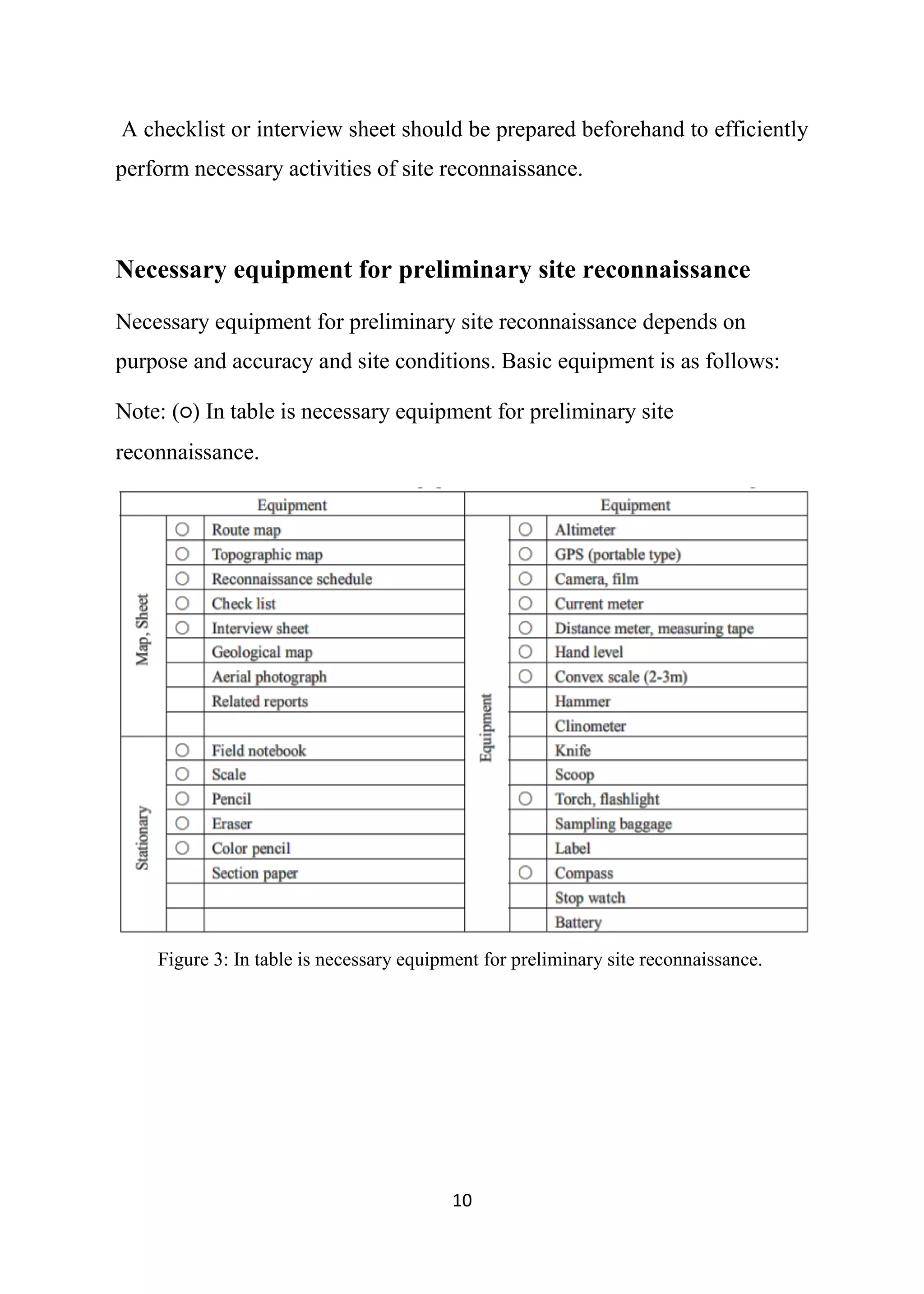
Necessary equipment for preliminary site reconnaissance
Necessary equipment for preliminary site reconnaissance depends on
purpose and accuracy and site conditions. Basic equipment is as follows:
Note: (○) In table is necessary equipment for preliminary site
reconnaissance.
Figure 3: In table is necessary equipment for preliminary site reconnaissance.
11
The Tidal Reconnaissance
Whenever possible it is advisable to use established or previously used tide
stations for commonality of data. When selecting a site for a tide gauge and
tide pole the following must be considered:
1. Ease of Erection Consider which is the easiest place to erect a tide
pole and gauge, some places are easier than Others, and some places
are impossible;
2. The Station Must Not Dry Out. The zero of the Tide Pole and Tide
Gauge pressure sensor should not dry out. If this is unavoidable a
secondary pole and gauge should be established below the level Of
the first gauge or pole;
3. Ease of Reading. The pole or gauge must be sited such that it can be
read at all times;
4. Security. Avoid situations where the tide pole and particularly the tide
gauge will be likely to be interfered with by the public, e.g. Fishing
boats berthing;
5. Shelter. The pole or gauge sensor should be sited away from the more
severe effects of weather sea and swell;
6. Protection. Ideally the tide gauge recorder should be placed in a
lockable building;
7. Proximity of Bench Marks. Select a station near to two benchmarks if
possible, to avoid time spent on long levelling runs;
8. Accessibility. If a tide watcher is employed, accommodation should
be close at hand. If a detached Boat Party is in operation the tide
station should be close to where the boat is moored, or close to the
tide party base.
12
CONCLUSION
At the result of this report it shows that reconnaissance of the hydrographic
survey Project helps to find out recognizing and discovering all details about
the project site in order to control the site buy the surveyor and he or she can
knowing what she or he needs and all the equipment and the most important
thing is the time should be considered.
At The end surveyor should collected all information the purpose of making
a good surveying and a successful Project within a precise and an accurate
results.
13
REFERENCES
[1]. International Hydrographic Organization (IHO), C-13, Chapter 7,
https://iho.int/en/capacity-building-
publications?fbclid=IwAR2bPLteXpsqjDAl4W2kwhMnLiK5XBiTDuGLOmB4BWjpF
WBqMp9Oo_6wn4Y
[2]. Website name: Surveying in water Hydro International
https://www.hydro-international.com/content/article/reconnaissance-surveying-using-
satellite-derived-bathymetry
[3]. Name book: Manual for Micro-hydro power Development, chapter 3,
https://openjicareport.jica.go.jp/643/643/643_108_11737046.html
[4]. Name presentation: hydrographic Surveying
https://cdn.ymaws.com/www.mnsurveyor.com/resource/resmgr/imported/2
012-C6A-Brunkhorst-Hydrography-Presentation-handout.pdf

More Related Content

What's hot

Hydrographic survey for std not print
Hydrographic survey for std not printHydrographic survey for std not print
Hydrographic survey for std not printGokul Saud
 
Ge 122 lecture 1 (GEODETIC CONTROL SURVEY) by: Broddett Bello abatayo
Ge 122 lecture 1 (GEODETIC CONTROL SURVEY) by: Broddett Bello abatayoGe 122 lecture 1 (GEODETIC CONTROL SURVEY) by: Broddett Bello abatayo
Ge 122 lecture 1 (GEODETIC CONTROL SURVEY) by: Broddett Bello abatayoBPA ABATAYO Land Surveying Services
 
Reconnaissance for Hydrographic Survey Project
Reconnaissance for Hydrographic  Survey ProjectReconnaissance for Hydrographic  Survey Project
Reconnaissance for Hydrographic Survey ProjectNzar Braim
 
Compass surveying
Compass surveyingCompass surveying
Compass surveyingRAHUL SINHA
 
Importance of geological considerations while choosing tunnel sites and align...
Importance of geological considerations while choosing tunnel sites and align...Importance of geological considerations while choosing tunnel sites and align...
Importance of geological considerations while choosing tunnel sites and align...Buddharatna godboley
 
Traverse Survey Part 1/2
Traverse Survey Part 1/2Traverse Survey Part 1/2
Traverse Survey Part 1/2Muhammad Zubair
 
Hydrographic Surveying By Jithin Jose
Hydrographic Surveying  By Jithin JoseHydrographic Surveying  By Jithin Jose
Hydrographic Surveying By Jithin JoseJithin Jose
 
Geophysical investigation
Geophysical investigation Geophysical investigation
Geophysical investigation shruthiv19
 
12.1. Horizontal and vertical control (1).pptx
12.1.  Horizontal and vertical control (1).pptx12.1.  Horizontal and vertical control (1).pptx
12.1. Horizontal and vertical control (1).pptxSaddoAjmal
 
Geometry of Aerial photograph
Geometry of Aerial photographGeometry of Aerial photograph
Geometry of Aerial photographApoorva Mathur
 

What's hot (20)

Hydrographic survey for std not print
Hydrographic survey for std not printHydrographic survey for std not print
Hydrographic survey for std not print
 
Ge 122 lecture 1 (GEODETIC CONTROL SURVEY) by: Broddett Bello abatayo
Ge 122 lecture 1 (GEODETIC CONTROL SURVEY) by: Broddett Bello abatayoGe 122 lecture 1 (GEODETIC CONTROL SURVEY) by: Broddett Bello abatayo
Ge 122 lecture 1 (GEODETIC CONTROL SURVEY) by: Broddett Bello abatayo
 
Reconnaissance for Hydrographic Survey Project
Reconnaissance for Hydrographic  Survey ProjectReconnaissance for Hydrographic  Survey Project
Reconnaissance for Hydrographic Survey Project
 
Stereoscopic Parallax
Stereoscopic ParallaxStereoscopic Parallax
Stereoscopic Parallax
 
Hydrography
Hydrography Hydrography
Hydrography
 
Compass surveying
Compass surveyingCompass surveying
Compass surveying
 
Serveying
ServeyingServeying
Serveying
 
Importance of geological considerations while choosing tunnel sites and align...
Importance of geological considerations while choosing tunnel sites and align...Importance of geological considerations while choosing tunnel sites and align...
Importance of geological considerations while choosing tunnel sites and align...
 
Traverse Survey Part 1/2
Traverse Survey Part 1/2Traverse Survey Part 1/2
Traverse Survey Part 1/2
 
Dredging
DredgingDredging
Dredging
 
Hydrographic Surveying By Jithin Jose
Hydrographic Surveying  By Jithin JoseHydrographic Surveying  By Jithin Jose
Hydrographic Surveying By Jithin Jose
 
Geophysical investigation
Geophysical investigation Geophysical investigation
Geophysical investigation
 
12.1. Horizontal and vertical control (1).pptx
12.1.  Horizontal and vertical control (1).pptx12.1.  Horizontal and vertical control (1).pptx
12.1. Horizontal and vertical control (1).pptx
 
Application of surveying
Application of surveyingApplication of surveying
Application of surveying
 
Triangulation survey
Triangulation surveyTriangulation survey
Triangulation survey
 
Geometry of Aerial photograph
Geometry of Aerial photographGeometry of Aerial photograph
Geometry of Aerial photograph
 
Hydrographic survey
Hydrographic surveyHydrographic survey
Hydrographic survey
 
Surveying and Leveling
Surveying and LevelingSurveying and Leveling
Surveying and Leveling
 
Dam, reservoir & tunnels
Dam, reservoir & tunnelsDam, reservoir & tunnels
Dam, reservoir & tunnels
 
Projection
ProjectionProjection
Projection
 

Similar to Reconnaissance for Hydrographic Surveying Project

1.2 iii-gl for-planning_the_projects_on_run_of_river
1.2 iii-gl for-planning_the_projects_on_run_of_river1.2 iii-gl for-planning_the_projects_on_run_of_river
1.2 iii-gl for-planning_the_projects_on_run_of_riverRavi Naid Gorle
 
Download-manuals-surface water-manual-sw-volume4fieldmanualhydrometryparti
 Download-manuals-surface water-manual-sw-volume4fieldmanualhydrometryparti Download-manuals-surface water-manual-sw-volume4fieldmanualhydrometryparti
Download-manuals-surface water-manual-sw-volume4fieldmanualhydrometrypartihydrologyproject001
 
Conceptual and geometric design of tunnel and quantity estimation
Conceptual and geometric design of tunnel and quantity estimationConceptual and geometric design of tunnel and quantity estimation
Conceptual and geometric design of tunnel and quantity estimationAtiqa khan
 
Methods of Shore Observations for Horizontal position Fixing
Methods of Shore Observations for Horizontal position FixingMethods of Shore Observations for Horizontal position Fixing
Methods of Shore Observations for Horizontal position FixingNzar Braim
 
Download-manuals-ground water-manual-gw-volume4fieldmanualgeo-hydrologypartviii
 Download-manuals-ground water-manual-gw-volume4fieldmanualgeo-hydrologypartviii Download-manuals-ground water-manual-gw-volume4fieldmanualgeo-hydrologypartviii
Download-manuals-ground water-manual-gw-volume4fieldmanualgeo-hydrologypartviiihydrologyproject001
 
Petronas exploration guidelines
Petronas exploration guidelinesPetronas exploration guidelines
Petronas exploration guidelinesEaswaran Kanason
 
Download-manuals-ground water-manual-gw-volume4fieldmanualgeo-hydrologypartiii
 Download-manuals-ground water-manual-gw-volume4fieldmanualgeo-hydrologypartiii Download-manuals-ground water-manual-gw-volume4fieldmanualgeo-hydrologypartiii
Download-manuals-ground water-manual-gw-volume4fieldmanualgeo-hydrologypartiiihydrologyproject001
 
Download-manuals-surface water-manual-sw-volume4fieldmanualhydrometrypartvi
 Download-manuals-surface water-manual-sw-volume4fieldmanualhydrometrypartvi Download-manuals-surface water-manual-sw-volume4fieldmanualhydrometrypartvi
Download-manuals-surface water-manual-sw-volume4fieldmanualhydrometrypartvihydrologyproject001
 
Download-manuals-ground water-manual-gw-volume4fieldmanualgeo-hydrologypartii
 Download-manuals-ground water-manual-gw-volume4fieldmanualgeo-hydrologypartii Download-manuals-ground water-manual-gw-volume4fieldmanualgeo-hydrologypartii
Download-manuals-ground water-manual-gw-volume4fieldmanualgeo-hydrologypartiihydrologyproject001
 
Easter Desert Project
Easter Desert ProjectEaster Desert Project
Easter Desert ProjectIwl Pcu
 
Solution Manual Elementary Surveying 15th edition by Ghilani.pdf
Solution Manual Elementary Surveying 15th edition by Ghilani.pdfSolution Manual Elementary Surveying 15th edition by Ghilani.pdf
Solution Manual Elementary Surveying 15th edition by Ghilani.pdfhmanavimm77
 
Structural geology
Structural geologyStructural geology
Structural geologyKhchao Tel
 
AIRPORT PLANNING AND DESIGN BY NIRANJAN
AIRPORT PLANNING AND DESIGN BY NIRANJANAIRPORT PLANNING AND DESIGN BY NIRANJAN
AIRPORT PLANNING AND DESIGN BY NIRANJANNiranjan Varma
 
AIRPORT PLANNING AND DESIGN
AIRPORT PLANNING AND DESIGNAIRPORT PLANNING AND DESIGN
AIRPORT PLANNING AND DESIGNNiranjan Varma
 

Similar to Reconnaissance for Hydrographic Surveying Project (20)

1.2 iii-gl for-planning_the_projects_on_run_of_river
1.2 iii-gl for-planning_the_projects_on_run_of_river1.2 iii-gl for-planning_the_projects_on_run_of_river
1.2 iii-gl for-planning_the_projects_on_run_of_river
 
Download-manuals-surface water-manual-sw-volume4fieldmanualhydrometryparti
 Download-manuals-surface water-manual-sw-volume4fieldmanualhydrometryparti Download-manuals-surface water-manual-sw-volume4fieldmanualhydrometryparti
Download-manuals-surface water-manual-sw-volume4fieldmanualhydrometryparti
 
Voyage-Planning PPT.ppt
Voyage-Planning PPT.pptVoyage-Planning PPT.ppt
Voyage-Planning PPT.ppt
 
Conceptual and geometric design of tunnel and quantity estimation
Conceptual and geometric design of tunnel and quantity estimationConceptual and geometric design of tunnel and quantity estimation
Conceptual and geometric design of tunnel and quantity estimation
 
Methods of Shore Observations for Horizontal position Fixing
Methods of Shore Observations for Horizontal position FixingMethods of Shore Observations for Horizontal position Fixing
Methods of Shore Observations for Horizontal position Fixing
 
Download-manuals-ground water-manual-gw-volume4fieldmanualgeo-hydrologypartviii
 Download-manuals-ground water-manual-gw-volume4fieldmanualgeo-hydrologypartviii Download-manuals-ground water-manual-gw-volume4fieldmanualgeo-hydrologypartviii
Download-manuals-ground water-manual-gw-volume4fieldmanualgeo-hydrologypartviii
 
Petronas exploration guidelines
Petronas exploration guidelinesPetronas exploration guidelines
Petronas exploration guidelines
 
Download-manuals-ground water-manual-gw-volume4fieldmanualgeo-hydrologypartiii
 Download-manuals-ground water-manual-gw-volume4fieldmanualgeo-hydrologypartiii Download-manuals-ground water-manual-gw-volume4fieldmanualgeo-hydrologypartiii
Download-manuals-ground water-manual-gw-volume4fieldmanualgeo-hydrologypartiii
 
Download-manuals-surface water-manual-sw-volume4fieldmanualhydrometrypartvi
 Download-manuals-surface water-manual-sw-volume4fieldmanualhydrometrypartvi Download-manuals-surface water-manual-sw-volume4fieldmanualhydrometrypartvi
Download-manuals-surface water-manual-sw-volume4fieldmanualhydrometrypartvi
 
Download-manuals-ground water-manual-gw-volume4fieldmanualgeo-hydrologypartii
 Download-manuals-ground water-manual-gw-volume4fieldmanualgeo-hydrologypartii Download-manuals-ground water-manual-gw-volume4fieldmanualgeo-hydrologypartii
Download-manuals-ground water-manual-gw-volume4fieldmanualgeo-hydrologypartii
 
Site organization
Site organizationSite organization
Site organization
 
Ijetr032314
Ijetr032314Ijetr032314
Ijetr032314
 
Easter Desert Project
Easter Desert ProjectEaster Desert Project
Easter Desert Project
 
unmanned aerial vehicle
unmanned aerial vehicleunmanned aerial vehicle
unmanned aerial vehicle
 
IRTG ppt.pptx
IRTG ppt.pptxIRTG ppt.pptx
IRTG ppt.pptx
 
Solution Manual Elementary Surveying 15th edition by Ghilani.pdf
Solution Manual Elementary Surveying 15th edition by Ghilani.pdfSolution Manual Elementary Surveying 15th edition by Ghilani.pdf
Solution Manual Elementary Surveying 15th edition by Ghilani.pdf
 
Structural geology
Structural geologyStructural geology
Structural geology
 
AIRPORT PLANNING AND DESIGN BY NIRANJAN
AIRPORT PLANNING AND DESIGN BY NIRANJANAIRPORT PLANNING AND DESIGN BY NIRANJAN
AIRPORT PLANNING AND DESIGN BY NIRANJAN
 
AIRPORT PLANNING AND DESIGN
AIRPORT PLANNING AND DESIGNAIRPORT PLANNING AND DESIGN
AIRPORT PLANNING AND DESIGN
 
Well logging
Well loggingWell logging
Well logging
 

More from Nzar Braim

Engineering Project Management
Engineering Project Management Engineering Project Management
Engineering Project Management Nzar Braim
 
The Effect of Declination on The Tide Pattern in Hydroghraphic Surveying
The Effect of Declination on The Tide Pattern in Hydroghraphic SurveyingThe Effect of Declination on The Tide Pattern in Hydroghraphic Surveying
The Effect of Declination on The Tide Pattern in Hydroghraphic SurveyingNzar Braim
 
Contribution Of Real Time Network (NRTK) for improvement of accuracy
Contribution Of Real Time Network (NRTK) for improvement of accuracyContribution Of Real Time Network (NRTK) for improvement of accuracy
Contribution Of Real Time Network (NRTK) for improvement of accuracyNzar Braim
 
Nominal & effective Interest Rates
Nominal & effective Interest RatesNominal & effective Interest Rates
Nominal & effective Interest RatesNzar Braim
 
Types of Walls (Brick,Concrete Block & Stone Walls)
Types of Walls (Brick,Concrete Block & Stone Walls)Types of Walls (Brick,Concrete Block & Stone Walls)
Types of Walls (Brick,Concrete Block & Stone Walls)Nzar Braim
 
Comparing alternatives in Engineering Economics and Management
Comparing alternatives in Engineering Economics and ManagementComparing alternatives in Engineering Economics and Management
Comparing alternatives in Engineering Economics and ManagementNzar Braim
 
Differentiation between primary and secondary LIDAR system of Remote Sensing
Differentiation between primary and secondary LIDAR system of Remote SensingDifferentiation between primary and secondary LIDAR system of Remote Sensing
Differentiation between primary and secondary LIDAR system of Remote SensingNzar Braim
 
The concept of total Horizontal and Vertical Uncertainty
The concept of total Horizontal and Vertical UncertaintyThe concept of total Horizontal and Vertical Uncertainty
The concept of total Horizontal and Vertical UncertaintyNzar Braim
 
Thermostone in Constrication or Thermostone
Thermostone in Constrication or ThermostoneThermostone in Constrication or Thermostone
Thermostone in Constrication or ThermostoneNzar Braim
 
Developing project objectives and Execution plan in Economy management
Developing project objectives and Execution plan in Economy management Developing project objectives and Execution plan in Economy management
Developing project objectives and Execution plan in Economy management Nzar Braim
 
Erbil Citadel - قةلَاي هةوليَر
Erbil Citadel - قةلَاي هةوليَرErbil Citadel - قةلَاي هةوليَر
Erbil Citadel - قةلَاي هةوليَرNzar Braim
 
SOIL STABILIZATION IN ROAD CONSTRUCTION AND MEASURING THE FIELD DENSITY [CO...
SOIL STABILIZATION IN ROAD CONSTRUCTION AND MEASURING  THE FIELD DENSITY  [CO...SOIL STABILIZATION IN ROAD CONSTRUCTION AND MEASURING  THE FIELD DENSITY  [CO...
SOIL STABILIZATION IN ROAD CONSTRUCTION AND MEASURING THE FIELD DENSITY [CO...Nzar Braim
 
Law of supply and demand
Law of supply and demandLaw of supply and demand
Law of supply and demandNzar Braim
 
Role of electromagnetic Radiation in Remote Sensing
Role of electromagnetic Radiation in  Remote SensingRole of electromagnetic Radiation in  Remote Sensing
Role of electromagnetic Radiation in Remote SensingNzar Braim
 
The Hyperbolic Radio System
The Hyperbolic Radio SystemThe Hyperbolic Radio System
The Hyperbolic Radio SystemNzar Braim
 
Car Parking Design in Urban Planning
Car Parking Design in Urban PlanningCar Parking Design in Urban Planning
Car Parking Design in Urban PlanningNzar Braim
 
Portland cement in concrete
Portland cement  in concrete Portland cement  in concrete
Portland cement in concrete Nzar Braim
 
Segregation in Concrete
Segregation in Concrete Segregation in Concrete
Segregation in Concrete Nzar Braim
 
Bar Graph Method in Engineering management
Bar Graph Method in Engineering management Bar Graph Method in Engineering management
Bar Graph Method in Engineering management Nzar Braim
 
Differentiation between Global and Local Datum from Different aspect
Differentiation between Global and Local Datum from Different aspect Differentiation between Global and Local Datum from Different aspect
Differentiation between Global and Local Datum from Different aspect Nzar Braim
 

More from Nzar Braim (20)

Engineering Project Management
Engineering Project Management Engineering Project Management
Engineering Project Management
 
The Effect of Declination on The Tide Pattern in Hydroghraphic Surveying
The Effect of Declination on The Tide Pattern in Hydroghraphic SurveyingThe Effect of Declination on The Tide Pattern in Hydroghraphic Surveying
The Effect of Declination on The Tide Pattern in Hydroghraphic Surveying
 
Contribution Of Real Time Network (NRTK) for improvement of accuracy
Contribution Of Real Time Network (NRTK) for improvement of accuracyContribution Of Real Time Network (NRTK) for improvement of accuracy
Contribution Of Real Time Network (NRTK) for improvement of accuracy
 
Nominal & effective Interest Rates
Nominal & effective Interest RatesNominal & effective Interest Rates
Nominal & effective Interest Rates
 
Types of Walls (Brick,Concrete Block & Stone Walls)
Types of Walls (Brick,Concrete Block & Stone Walls)Types of Walls (Brick,Concrete Block & Stone Walls)
Types of Walls (Brick,Concrete Block & Stone Walls)
 
Comparing alternatives in Engineering Economics and Management
Comparing alternatives in Engineering Economics and ManagementComparing alternatives in Engineering Economics and Management
Comparing alternatives in Engineering Economics and Management
 
Differentiation between primary and secondary LIDAR system of Remote Sensing
Differentiation between primary and secondary LIDAR system of Remote SensingDifferentiation between primary and secondary LIDAR system of Remote Sensing
Differentiation between primary and secondary LIDAR system of Remote Sensing
 
The concept of total Horizontal and Vertical Uncertainty
The concept of total Horizontal and Vertical UncertaintyThe concept of total Horizontal and Vertical Uncertainty
The concept of total Horizontal and Vertical Uncertainty
 
Thermostone in Constrication or Thermostone
Thermostone in Constrication or ThermostoneThermostone in Constrication or Thermostone
Thermostone in Constrication or Thermostone
 
Developing project objectives and Execution plan in Economy management
Developing project objectives and Execution plan in Economy management Developing project objectives and Execution plan in Economy management
Developing project objectives and Execution plan in Economy management
 
Erbil Citadel - قةلَاي هةوليَر
Erbil Citadel - قةلَاي هةوليَرErbil Citadel - قةلَاي هةوليَر
Erbil Citadel - قةلَاي هةوليَر
 
SOIL STABILIZATION IN ROAD CONSTRUCTION AND MEASURING THE FIELD DENSITY [CO...
SOIL STABILIZATION IN ROAD CONSTRUCTION AND MEASURING  THE FIELD DENSITY  [CO...SOIL STABILIZATION IN ROAD CONSTRUCTION AND MEASURING  THE FIELD DENSITY  [CO...
SOIL STABILIZATION IN ROAD CONSTRUCTION AND MEASURING THE FIELD DENSITY [CO...
 
Law of supply and demand
Law of supply and demandLaw of supply and demand
Law of supply and demand
 
Role of electromagnetic Radiation in Remote Sensing
Role of electromagnetic Radiation in  Remote SensingRole of electromagnetic Radiation in  Remote Sensing
Role of electromagnetic Radiation in Remote Sensing
 
The Hyperbolic Radio System
The Hyperbolic Radio SystemThe Hyperbolic Radio System
The Hyperbolic Radio System
 
Car Parking Design in Urban Planning
Car Parking Design in Urban PlanningCar Parking Design in Urban Planning
Car Parking Design in Urban Planning
 
Portland cement in concrete
Portland cement  in concrete Portland cement  in concrete
Portland cement in concrete
 
Segregation in Concrete
Segregation in Concrete Segregation in Concrete
Segregation in Concrete
 
Bar Graph Method in Engineering management
Bar Graph Method in Engineering management Bar Graph Method in Engineering management
Bar Graph Method in Engineering management
 
Differentiation between Global and Local Datum from Different aspect
Differentiation between Global and Local Datum from Different aspect Differentiation between Global and Local Datum from Different aspect
Differentiation between Global and Local Datum from Different aspect
 

Recently uploaded

The Most Attractive Pune Call Girls Budhwar Peth 8250192130 Will You Miss Thi...
The Most Attractive Pune Call Girls Budhwar Peth 8250192130 Will You Miss Thi...The Most Attractive Pune Call Girls Budhwar Peth 8250192130 Will You Miss Thi...
The Most Attractive Pune Call Girls Budhwar Peth 8250192130 Will You Miss Thi...ranjana rawat
 
VIP Call Girls Service Kondapur Hyderabad Call +91-8250192130
VIP Call Girls Service Kondapur Hyderabad Call +91-8250192130VIP Call Girls Service Kondapur Hyderabad Call +91-8250192130
VIP Call Girls Service Kondapur Hyderabad Call +91-8250192130Suhani Kapoor
 
Top Rated Pune Call Girls Budhwar Peth ⟟ 6297143586 ⟟ Call Me For Genuine Se...
Top Rated  Pune Call Girls Budhwar Peth ⟟ 6297143586 ⟟ Call Me For Genuine Se...Top Rated  Pune Call Girls Budhwar Peth ⟟ 6297143586 ⟟ Call Me For Genuine Se...
Top Rated Pune Call Girls Budhwar Peth ⟟ 6297143586 ⟟ Call Me For Genuine Se...Call Girls in Nagpur High Profile
 
High Profile Call Girls Nagpur Isha Call 7001035870 Meet With Nagpur Escorts
High Profile Call Girls Nagpur Isha Call 7001035870 Meet With Nagpur EscortsHigh Profile Call Girls Nagpur Isha Call 7001035870 Meet With Nagpur Escorts
High Profile Call Girls Nagpur Isha Call 7001035870 Meet With Nagpur Escortsranjana rawat
 
Sheet Pile Wall Design and Construction: A Practical Guide for Civil Engineer...
Sheet Pile Wall Design and Construction: A Practical Guide for Civil Engineer...Sheet Pile Wall Design and Construction: A Practical Guide for Civil Engineer...
Sheet Pile Wall Design and Construction: A Practical Guide for Civil Engineer...Dr.Costas Sachpazis
 
UNIT-III FMM. DIMENSIONAL ANALYSIS
UNIT-III FMM.        DIMENSIONAL ANALYSISUNIT-III FMM.        DIMENSIONAL ANALYSIS
UNIT-III FMM. DIMENSIONAL ANALYSISrknatarajan
 
(PRIYA) Rajgurunagar Call Girls Just Call 7001035870 [ Cash on Delivery ] Pun...
(PRIYA) Rajgurunagar Call Girls Just Call 7001035870 [ Cash on Delivery ] Pun...(PRIYA) Rajgurunagar Call Girls Just Call 7001035870 [ Cash on Delivery ] Pun...
(PRIYA) Rajgurunagar Call Girls Just Call 7001035870 [ Cash on Delivery ] Pun...ranjana rawat
 
Booking open Available Pune Call Girls Koregaon Park 6297143586 Call Hot Ind...
Booking open Available Pune Call Girls Koregaon Park  6297143586 Call Hot Ind...Booking open Available Pune Call Girls Koregaon Park  6297143586 Call Hot Ind...
Booking open Available Pune Call Girls Koregaon Park 6297143586 Call Hot Ind...Call Girls in Nagpur High Profile
 
College Call Girls Nashik Nehal 7001305949 Independent Escort Service Nashik
College Call Girls Nashik Nehal 7001305949 Independent Escort Service NashikCollege Call Girls Nashik Nehal 7001305949 Independent Escort Service Nashik
College Call Girls Nashik Nehal 7001305949 Independent Escort Service NashikCall Girls in Nagpur High Profile
 
Call for Papers - Educational Administration: Theory and Practice, E-ISSN: 21...
Call for Papers - Educational Administration: Theory and Practice, E-ISSN: 21...Call for Papers - Educational Administration: Theory and Practice, E-ISSN: 21...
Call for Papers - Educational Administration: Theory and Practice, E-ISSN: 21...Christo Ananth
 
Call Girls Service Nagpur Tanvi Call 7001035870 Meet With Nagpur Escorts
Call Girls Service Nagpur Tanvi Call 7001035870 Meet With Nagpur EscortsCall Girls Service Nagpur Tanvi Call 7001035870 Meet With Nagpur Escorts
Call Girls Service Nagpur Tanvi Call 7001035870 Meet With Nagpur EscortsCall Girls in Nagpur High Profile
 
Introduction to IEEE STANDARDS and its different types.pptx
Introduction to IEEE STANDARDS and its different types.pptxIntroduction to IEEE STANDARDS and its different types.pptx
Introduction to IEEE STANDARDS and its different types.pptxupamatechverse
 
Coefficient of Thermal Expansion and their Importance.pptx
Coefficient of Thermal Expansion and their Importance.pptxCoefficient of Thermal Expansion and their Importance.pptx
Coefficient of Thermal Expansion and their Importance.pptxAsutosh Ranjan
 
Extrusion Processes and Their Limitations
Extrusion Processes and Their LimitationsExtrusion Processes and Their Limitations
Extrusion Processes and Their Limitations120cr0395
 
CCS335 _ Neural Networks and Deep Learning Laboratory_Lab Complete Record
CCS335 _ Neural Networks and Deep Learning Laboratory_Lab Complete RecordCCS335 _ Neural Networks and Deep Learning Laboratory_Lab Complete Record
CCS335 _ Neural Networks and Deep Learning Laboratory_Lab Complete RecordAsst.prof M.Gokilavani
 
Processing & Properties of Floor and Wall Tiles.pptx
Processing & Properties of Floor and Wall Tiles.pptxProcessing & Properties of Floor and Wall Tiles.pptx
Processing & Properties of Floor and Wall Tiles.pptxpranjaldaimarysona
 
HARMONY IN THE NATURE AND EXISTENCE - Unit-IV
HARMONY IN THE NATURE AND EXISTENCE - Unit-IVHARMONY IN THE NATURE AND EXISTENCE - Unit-IV
HARMONY IN THE NATURE AND EXISTENCE - Unit-IVRajaP95
 
UNIT - IV - Air Compressors and its Performance
UNIT - IV - Air Compressors and its PerformanceUNIT - IV - Air Compressors and its Performance
UNIT - IV - Air Compressors and its Performancesivaprakash250
 
IMPLICATIONS OF THE ABOVE HOLISTIC UNDERSTANDING OF HARMONY ON PROFESSIONAL E...
IMPLICATIONS OF THE ABOVE HOLISTIC UNDERSTANDING OF HARMONY ON PROFESSIONAL E...IMPLICATIONS OF THE ABOVE HOLISTIC UNDERSTANDING OF HARMONY ON PROFESSIONAL E...
IMPLICATIONS OF THE ABOVE HOLISTIC UNDERSTANDING OF HARMONY ON PROFESSIONAL E...RajaP95
 

Recently uploaded (20)

The Most Attractive Pune Call Girls Budhwar Peth 8250192130 Will You Miss Thi...
The Most Attractive Pune Call Girls Budhwar Peth 8250192130 Will You Miss Thi...The Most Attractive Pune Call Girls Budhwar Peth 8250192130 Will You Miss Thi...
The Most Attractive Pune Call Girls Budhwar Peth 8250192130 Will You Miss Thi...
 
VIP Call Girls Service Kondapur Hyderabad Call +91-8250192130
VIP Call Girls Service Kondapur Hyderabad Call +91-8250192130VIP Call Girls Service Kondapur Hyderabad Call +91-8250192130
VIP Call Girls Service Kondapur Hyderabad Call +91-8250192130
 
Top Rated Pune Call Girls Budhwar Peth ⟟ 6297143586 ⟟ Call Me For Genuine Se...
Top Rated  Pune Call Girls Budhwar Peth ⟟ 6297143586 ⟟ Call Me For Genuine Se...Top Rated  Pune Call Girls Budhwar Peth ⟟ 6297143586 ⟟ Call Me For Genuine Se...
Top Rated Pune Call Girls Budhwar Peth ⟟ 6297143586 ⟟ Call Me For Genuine Se...
 
High Profile Call Girls Nagpur Isha Call 7001035870 Meet With Nagpur Escorts
High Profile Call Girls Nagpur Isha Call 7001035870 Meet With Nagpur EscortsHigh Profile Call Girls Nagpur Isha Call 7001035870 Meet With Nagpur Escorts
High Profile Call Girls Nagpur Isha Call 7001035870 Meet With Nagpur Escorts
 
Sheet Pile Wall Design and Construction: A Practical Guide for Civil Engineer...
Sheet Pile Wall Design and Construction: A Practical Guide for Civil Engineer...Sheet Pile Wall Design and Construction: A Practical Guide for Civil Engineer...
Sheet Pile Wall Design and Construction: A Practical Guide for Civil Engineer...
 
UNIT-III FMM. DIMENSIONAL ANALYSIS
UNIT-III FMM.        DIMENSIONAL ANALYSISUNIT-III FMM.        DIMENSIONAL ANALYSIS
UNIT-III FMM. DIMENSIONAL ANALYSIS
 
(PRIYA) Rajgurunagar Call Girls Just Call 7001035870 [ Cash on Delivery ] Pun...
(PRIYA) Rajgurunagar Call Girls Just Call 7001035870 [ Cash on Delivery ] Pun...(PRIYA) Rajgurunagar Call Girls Just Call 7001035870 [ Cash on Delivery ] Pun...
(PRIYA) Rajgurunagar Call Girls Just Call 7001035870 [ Cash on Delivery ] Pun...
 
Booking open Available Pune Call Girls Koregaon Park 6297143586 Call Hot Ind...
Booking open Available Pune Call Girls Koregaon Park  6297143586 Call Hot Ind...Booking open Available Pune Call Girls Koregaon Park  6297143586 Call Hot Ind...
Booking open Available Pune Call Girls Koregaon Park 6297143586 Call Hot Ind...
 
College Call Girls Nashik Nehal 7001305949 Independent Escort Service Nashik
College Call Girls Nashik Nehal 7001305949 Independent Escort Service NashikCollege Call Girls Nashik Nehal 7001305949 Independent Escort Service Nashik
College Call Girls Nashik Nehal 7001305949 Independent Escort Service Nashik
 
Call for Papers - Educational Administration: Theory and Practice, E-ISSN: 21...
Call for Papers - Educational Administration: Theory and Practice, E-ISSN: 21...Call for Papers - Educational Administration: Theory and Practice, E-ISSN: 21...
Call for Papers - Educational Administration: Theory and Practice, E-ISSN: 21...
 
Call Girls Service Nagpur Tanvi Call 7001035870 Meet With Nagpur Escorts
Call Girls Service Nagpur Tanvi Call 7001035870 Meet With Nagpur EscortsCall Girls Service Nagpur Tanvi Call 7001035870 Meet With Nagpur Escorts
Call Girls Service Nagpur Tanvi Call 7001035870 Meet With Nagpur Escorts
 
Introduction to IEEE STANDARDS and its different types.pptx
Introduction to IEEE STANDARDS and its different types.pptxIntroduction to IEEE STANDARDS and its different types.pptx
Introduction to IEEE STANDARDS and its different types.pptx
 
Coefficient of Thermal Expansion and their Importance.pptx
Coefficient of Thermal Expansion and their Importance.pptxCoefficient of Thermal Expansion and their Importance.pptx
Coefficient of Thermal Expansion and their Importance.pptx
 
Extrusion Processes and Their Limitations
Extrusion Processes and Their LimitationsExtrusion Processes and Their Limitations
Extrusion Processes and Their Limitations
 
CCS335 _ Neural Networks and Deep Learning Laboratory_Lab Complete Record
CCS335 _ Neural Networks and Deep Learning Laboratory_Lab Complete RecordCCS335 _ Neural Networks and Deep Learning Laboratory_Lab Complete Record
CCS335 _ Neural Networks and Deep Learning Laboratory_Lab Complete Record
 
Processing & Properties of Floor and Wall Tiles.pptx
Processing & Properties of Floor and Wall Tiles.pptxProcessing & Properties of Floor and Wall Tiles.pptx
Processing & Properties of Floor and Wall Tiles.pptx
 
Roadmap to Membership of RICS - Pathways and Routes
Roadmap to Membership of RICS - Pathways and RoutesRoadmap to Membership of RICS - Pathways and Routes
Roadmap to Membership of RICS - Pathways and Routes
 
HARMONY IN THE NATURE AND EXISTENCE - Unit-IV
HARMONY IN THE NATURE AND EXISTENCE - Unit-IVHARMONY IN THE NATURE AND EXISTENCE - Unit-IV
HARMONY IN THE NATURE AND EXISTENCE - Unit-IV
 
UNIT - IV - Air Compressors and its Performance
UNIT - IV - Air Compressors and its PerformanceUNIT - IV - Air Compressors and its Performance
UNIT - IV - Air Compressors and its Performance
 
IMPLICATIONS OF THE ABOVE HOLISTIC UNDERSTANDING OF HARMONY ON PROFESSIONAL E...
IMPLICATIONS OF THE ABOVE HOLISTIC UNDERSTANDING OF HARMONY ON PROFESSIONAL E...IMPLICATIONS OF THE ABOVE HOLISTIC UNDERSTANDING OF HARMONY ON PROFESSIONAL E...
IMPLICATIONS OF THE ABOVE HOLISTIC UNDERSTANDING OF HARMONY ON PROFESSIONAL E...
 

Reconnaissance for Hydrographic Surveying Project

  • 1. Reconnaissance for Hydrographic Surveying Project Student Name: Nzar Braim Omar Class: 4th Stage Course Title: Hydrographic Surveying Department: Geomatics (Surveying) Engineering College of Engineering Salahaddin University-Erbil Academic Year 2019-2020
  • 2. 2 Abstract This report talks about how the reconnaissance will be and it is effectively important the place that we survey and observation so the surveyor should prepare himself or herself for the project visiting site and site survey and planning and so on. Observer visiting the site many times daily to see what is the situation and the condition and booking his or her notes recording them such as is the site ready to start the observation? Or is the site has safety to start? I mean replace safety conditions and also must have collected all this information and choose which instrument this site or this project and many other conditions should be considered after all above that I have mentioned he or she decides to start and beginning Project and surveying or not. This is the idea or this the outline recognize.
  • 3. 3 Table of Content Subject page Abstract …………………………………………………………….. 2 Table of Contents …………...……………………………………… 3 Introduction …………………………………………………............ 4 The Geodetic Reconnaissance ……………………………………… 6 Reconnaissance surveying using Satellite ………………………….. 7 Objective of Site Reconnaissance ………………………………….. 8 Preparation for Site Reconnaissance ………………………………. 8 Information gathering and preparation …………………………….. 9 Planning of preliminary site reconnaissance ……………………….. 9 Necessary equipment for preliminary site reconnaissance ………… 10 The Tidal Reconnaissance …………………………………………. 11 Conclusion …………………………………………………………. 12 Reference …………………………………………………………... 13
  • 4. 4 Introduction Hydrography is the branch of applied sciences which deals with the measurement and description of the physical features of oceans, seas, coastal areas, lakes and rivers, as well as with the prediction of their change over time, for the primary purpose of safety of navigation and in support of all other marine activities, including economic development, security and defense, scientific research, and environmental protection. (International Hydrographic Organization), hydrographic surveys may be broadly classified as: • Reconnaissance or Class 3 • Project condition or design or Class 2 • Contract payment or Class 1 Reconnaissance as every project require a start-up plan to complete it effectively and economically, reconnaissance has to be undergone. A complete reconnaissance of whole survey area to choose the best way of performing the survey. Reconnaissance is needed prior to any survey to acquire the necessary data to permit the best and most economical survey to be carried out. The information collected should cater for the design, planning, organization and observations of the proposed task. The reconnaissance may be carried out immediately before the survey, or many months in advance [1]. The reconnaissance is important; a bad one can result in wasted time and effort later, when much more expensive assets are likely to be involved.
  • 5. 5 It should also be complete because a poor reconnaissance will inevitably result in a poor plan. The surveyor called upon to do the reconnaissance should possess experience, commonsense, a sound knowledge of all equipment available, and have no preconceived ideas about the method by which the task will be carried out. The actual observations can safely be left to less experienced surveyors once the major decisions have been taken.
  • 6. 6 The Geodetic Reconnaissance The purposes of the reconnaissance can be summarized [1] as follows: 1. Establish local contacts in person. 2. Visit all proposed stations - select actual sites. Recover existing control stations. 3. Confirm inter-visibilities. 4. Decide upon final network design (re-analyses if necessary). 5. Permanently mark geodetic stations. 6. Describe geodetic stations. 7. Prove the proposed observing plan (instruments/targets required). Prepare detailed observing program. 8. Prove the administrative plan for the main survey, amend as necessary. For each new geodetic station, the following information will be required: 1. Accessibility by road, rail, boat, foot or helicopter. Time for access (e.g. on foot from road) and recommended route. 2. Visibility from station and requirements for any subsequent clearing. 3. Description of the station, magnetic bearings to other visible stations. 4. Photographs of the station, surroundings, and panoramic photos from the station. 5. Local factors, customs etc. 6. Likely visibility and meteorological conditions.
  • 7. 7 Reconnaissance surveying using Satellite The reconnaissance survey is an extensive study of an entire area that might be used for a road or airfield. Its purpose is to eliminate those routes or sites which are impractical or unfeasible and to identify the more promising routes or sites. Existing maps and aerial photographs may be of great help. Figure 1: Reconnaissance surveying using Satellite-derived Bathymetry [2].
  • 8. 8 Objective of Site Reconnaissance The objective of site reconnaissance for micro-hydro is to investigate plant sites and supply area in order to evaluate the feasibility of projects and get information for electrification planning [3]. One of the most important activities in site reconnaissance is to measure water discharge and head that could be utilized for micro-hydro generation. Investigations of intake site, waterway route, powerhouse site and transmission route etc. are also conducted to assess the feasibility of project sites. Power demand survey is also important in the planning of the electrification system. Socio economic data such as number of households and public facilities in supply area, availability of local industries that will use electricity, solvency of local people for electricity, and the acceptability of local people to the electrification scheme are gathered during the reconnaissance survey. Preparation for Site Reconnaissance To achieve effective and fruitful site reconnaissance, it is important to conduct preparation such as gathering of available information, and devise a sufficient plan and schedule of survey activities in advance.
  • 9. 9 Information gathering and preparation As advance information, 1/50,000 topographic maps are prepared to check the topography of the target site and villages, the catchment area, village’s distribution and access road. More accurate information on site accessibility could be collected by contacting local people concerned. Copies of 1/50,000 topographic maps and route maps enlarged by 200 to 400% are prepared for the fieldwork. Check list and interview sheet are also prepared for each site reconnaissance. Planning of preliminary site reconnaissance Although it may be required to deviate from original plan and schedule in accordance with site conditions, it is important to make a sufficient plan and schedule for site reconnaissance activities in advance. It is also necessary to coordinate with local officials concerned to insure safety and successful conduct of the reconnaissance activities. Since most micro-hydro sites are located in mountainous and isolated areas, it requires longer time to conduct site reconnaissance activities. Therefore, sufficient schedule should be considered to have enough time for the fieldwork. Also, measurement and other activities for site reconnaissance should be taken into account. Figure 2: The mapping of bodies of water [4].
  • 10. 10 A checklist or interview sheet should be prepared beforehand to efficiently perform necessary activities of site reconnaissance. Necessary equipment for preliminary site reconnaissance Necessary equipment for preliminary site reconnaissance depends on purpose and accuracy and site conditions. Basic equipment is as follows: Note: (○) In table is necessary equipment for preliminary site reconnaissance. Figure 3: In table is necessary equipment for preliminary site reconnaissance.
  • 11. 11 The Tidal Reconnaissance Whenever possible it is advisable to use established or previously used tide stations for commonality of data. When selecting a site for a tide gauge and tide pole the following must be considered: 1. Ease of Erection Consider which is the easiest place to erect a tide pole and gauge, some places are easier than Others, and some places are impossible; 2. The Station Must Not Dry Out. The zero of the Tide Pole and Tide Gauge pressure sensor should not dry out. If this is unavoidable a secondary pole and gauge should be established below the level Of the first gauge or pole; 3. Ease of Reading. The pole or gauge must be sited such that it can be read at all times; 4. Security. Avoid situations where the tide pole and particularly the tide gauge will be likely to be interfered with by the public, e.g. Fishing boats berthing; 5. Shelter. The pole or gauge sensor should be sited away from the more severe effects of weather sea and swell; 6. Protection. Ideally the tide gauge recorder should be placed in a lockable building; 7. Proximity of Bench Marks. Select a station near to two benchmarks if possible, to avoid time spent on long levelling runs; 8. Accessibility. If a tide watcher is employed, accommodation should be close at hand. If a detached Boat Party is in operation the tide station should be close to where the boat is moored, or close to the tide party base.
  • 12. 12 CONCLUSION At the result of this report it shows that reconnaissance of the hydrographic survey Project helps to find out recognizing and discovering all details about the project site in order to control the site buy the surveyor and he or she can knowing what she or he needs and all the equipment and the most important thing is the time should be considered. At The end surveyor should collected all information the purpose of making a good surveying and a successful Project within a precise and an accurate results.
  • 13. 13 REFERENCES [1]. International Hydrographic Organization (IHO), C-13, Chapter 7, https://iho.int/en/capacity-building- publications?fbclid=IwAR2bPLteXpsqjDAl4W2kwhMnLiK5XBiTDuGLOmB4BWjpF WBqMp9Oo_6wn4Y [2]. Website name: Surveying in water Hydro International https://www.hydro-international.com/content/article/reconnaissance-surveying-using- satellite-derived-bathymetry [3]. Name book: Manual for Micro-hydro power Development, chapter 3, https://openjicareport.jica.go.jp/643/643/643_108_11737046.html [4]. Name presentation: hydrographic Surveying https://cdn.ymaws.com/www.mnsurveyor.com/resource/resmgr/imported/2 012-C6A-Brunkhorst-Hydrography-Presentation-handout.pdf