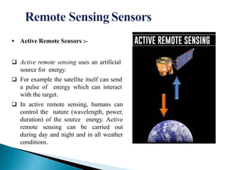
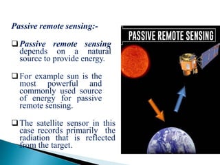
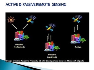
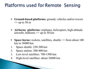
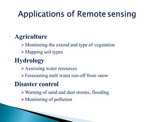
 Remote sensing is defined as the technique
of obtaining information about objects
through the analysis of data collected by
special instruments that are not in physical
contact with the objects of investigation.
 Collection of information about an object
without coming into physical contact.
 The information needs a physical carrier to
travel from the objects/events to the sensors
through an intervening medium.
 The electromagnetic radiation is normally
used as an information carrier in remote
sensing.
 The output of a remote sensing system is
usually an image representing the scene
being observed.
1. Energy Source or Illumination
(A)
2. Radiation and theAtmosphere
(B)
3. Interaction with the Object (C)
4. Recording of Energy by the
Sensor (D)
5. Transmission, Reception and
Processing (E)
6. Interpretation and Analysis (F)
7. Application (G)
 Active Remote Sensors :-
 Active remote sensing uses an artificial
source for energy.
 For example the satellite itself can send
a pulse of energy which can interact
with the target.
 In active remote sensing, humans can
control the nature (wavelength, power,
duration) of the source energy. Active
remote sensing can be carried out
during day and night and in all weather
conditions.
Passive remote sensing:-
Passive remote sensing
depends on a natural
source to provide energy.
For example sun is the
most powerful and
commonly used source
of energy for passive
remote sensing.
The satellite sensor in this
case records primarily the
radiation that is reflected
from the target.
ACTIVE & PASSIVEREMOTE SENSING
Platforms :
The base on which remote
sensors are placed to
acquire information about
the Earth surface is called
platforms.
• Ground based
• Airborne
• Space borne
 Ground-based platforms: ground, vehicles and/or towers
=> up to 50 m
 Airborne platforms: airplanes, helicopters, high-altitude
aircrafts, balloons => up to 50 km
 Space borne: rockets, satellites, shuttle => from about 100
km to 36000 km
1. Space shuttle: 250-300 km
2. Space station: 300-400 km
3. Low-level satellites: 700-1500 km
4. High-level satellites: about 36000 km
 Providesaregionalview(largeareas).
 Providesrepetitivelooksatthesamearea.
 Remote sensors "see" over a broader.
portionofthespectrumthanthehuman eye.
 Providesgeo-referenced,digital,data.
 Some remote sensors operate in all
seasons,atnight,andinbadweather.
 Expensivetobuildandoperate
 Needs ground verification
 Not the best tool for small areas
 Needs expert system to extract data
 Agriculture
Monitoring the extend and type of vegetation
Mapping soil types
 Hydrology
Assessing water resources
Forecasting melt water run-off from snow
 Disaster control
Warning of sand and dust storms, flooding
Monitoring of pollution
REMOTE SENSING........btech civil ..pptx

REMOTE SENSING........btech civil ..pptx

  • 2.
     Remote sensingis defined as the technique of obtaining information about objects through the analysis of data collected by special instruments that are not in physical contact with the objects of investigation.  Collection of information about an object without coming into physical contact.  The information needs a physical carrier to travel from the objects/events to the sensors through an intervening medium.  The electromagnetic radiation is normally used as an information carrier in remote sensing.  The output of a remote sensing system is usually an image representing the scene being observed.
  • 3.
    1. Energy Sourceor Illumination (A) 2. Radiation and theAtmosphere (B) 3. Interaction with the Object (C) 4. Recording of Energy by the Sensor (D) 5. Transmission, Reception and Processing (E) 6. Interpretation and Analysis (F) 7. Application (G)
  • 4.
     Active RemoteSensors :-  Active remote sensing uses an artificial source for energy.  For example the satellite itself can send a pulse of energy which can interact with the target.  In active remote sensing, humans can control the nature (wavelength, power, duration) of the source energy. Active remote sensing can be carried out during day and night and in all weather conditions.
  • 5.
    Passive remote sensing:- Passiveremote sensing depends on a natural source to provide energy. For example sun is the most powerful and commonly used source of energy for passive remote sensing. The satellite sensor in this case records primarily the radiation that is reflected from the target.
  • 6.
  • 7.
    Platforms : The baseon which remote sensors are placed to acquire information about the Earth surface is called platforms. • Ground based • Airborne • Space borne
  • 8.
     Ground-based platforms:ground, vehicles and/or towers => up to 50 m  Airborne platforms: airplanes, helicopters, high-altitude aircrafts, balloons => up to 50 km  Space borne: rockets, satellites, shuttle => from about 100 km to 36000 km 1. Space shuttle: 250-300 km 2. Space station: 300-400 km 3. Low-level satellites: 700-1500 km 4. High-level satellites: about 36000 km
  • 9.
     Providesaregionalview(largeareas).  Providesrepetitivelooksatthesamearea. Remote sensors "see" over a broader. portionofthespectrumthanthehuman eye.  Providesgeo-referenced,digital,data.  Some remote sensors operate in all seasons,atnight,andinbadweather.
  • 10.
     Expensivetobuildandoperate  Needsground verification  Not the best tool for small areas  Needs expert system to extract data
  • 11.
     Agriculture Monitoring theextend and type of vegetation Mapping soil types  Hydrology Assessing water resources Forecasting melt water run-off from snow  Disaster control Warning of sand and dust storms, flooding Monitoring of pollution