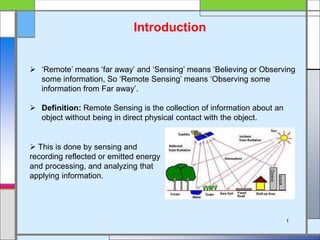
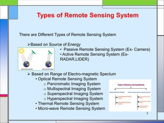
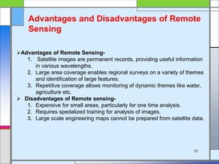
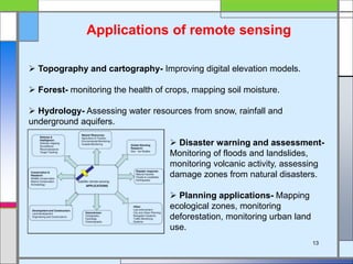
BASIC CONCEPTS OF REMOTE SENSING
SOMENATH GOSWAMI
UID NO.- 21143031032
MSc In GEO-INFORMATICS
1St Semester
P.R.M.S. MAHAVIDYALAYA
BANKURA UNIVERSITY
1
Introduction
 ā€˜Remote’ means ā€˜far away’ and ā€˜Sensing’ means ā€˜Believing or Observing
some information, So ā€˜Remote Sensing’ means ā€˜Observing some
information from Far away’.
 Definition: Remote Sensing is the collection of information about an
object without being in direct physical contact with the object.
 This is done by sensing and
recording reflected or emitted energy
and processing, and analyzing that
applying information.
Types of Remote Sensing System
There are Different Types of Remote Sensing System
Based on Source of Energy
• Passive Remote Sensing System (Ex- Camera)
• Active Remote Sensing System (Ex-
RADAR,LIDER)
 Based on Range of Electro-magnetic Spectum
• Optical Remote Sensing System
o Pancromatic Imaging System
o Multispectral Imaging System
o Superspectral Imaging System
o Hyperspectral Imaging System
• Thermal Remote Sensing System
• Micro-wave Remote Sensing System
2
Processes and Elements of Remote
Sensing
 Data Acquisition
• Source of Energy
• Radiation & Atmosphere
• Interaction with Targets
• Recording of Energy by Sensor
• Transmission & Reception
 Data Analysis
• Interpretation and Analysis
• Application
3
Electro-magnetic Radiation
 The foundation of remote sensing technology is based on the
measurement and interpretation of the patterns of EMR. EMR is a dynamic
form of energy. EMR transmit cross space in the wave form and in the speed
of light. The whole range of EMR is called spectrum.
 The Sun light is the Exampel of EMR
• Wave Velocity
• Wave Langth
• Wane Frequency
4
Electro-magnetic Spectrum
The electromagnetic spectrum is the range of frequencies (the spectrum) of
electromagnetic radiation and their respective wavelengths and photon
energies.
 Human eyes can only measure visible light but sensors can measure other
portions of EMS.
5
Energy Interaction With Atmosphere
 Transmission of Energy- The release of energy from a substance is called
energy transmission. When the energy of an electromagnet is transmitted
through a medium without any change, it is called Transmission.
 Refraction of Energy- Refraction is a feature of the flow of light where light
rays bend towards the speed of light to change the density of the medium as it
enters from one medium to another.
 Reflection of Energy- Reflection means
that they are thrown back from a surface
 Absorption of Energy- Absorption
means that they are incorporated by a
surface. Different surfaces reflect and
absorb differently. The ratio between
absorption and reflection is called albedo.
 Scattering of Energy- When energy waves (such as light, sound, and
various electromagnetic waves) are caused to depart from a straight path due
to imperfections in the medium, it is called scattering.
6
Atmospheric Window
 The Atmosphere absorbs some this to pass through. The places where
energy passes through are called ā€˜Atmospheric Window’.
 An atmospheric window is a range of wavelengths of the electromagnetic
spectrum that can pass through the earth's atmosphere. The optical, infrared
and radio windows comprise the three main atmospheric windows.
 We use these "windows" in remote
sensing to peer into the atmosphere
from which we can obtain much
information concerning the weather.
7
Sensor
 In remote sensing management, a device that receives incoming
electromagnetic radiation and converts it into a digital electronics signal, is
called Sensor.
1. Active Sensor- Sensors that artificially collect energy from
source of energy are called Active Sensor. (Ex- RADAR)
2. Passive Sensor- Sensors that collect reflected
electromagnetic radiation from natural source are called
Passive Sensor. (Ex- LISS-I)
8
Platform
 Platforms are used to house the sensors which obtain data for remote
sensing purposes.
The distance between the target being imaged and the platform, plays a
large role in determining the detail of information obtained and the total area
imaged by the sensor.
 Platform are-
1. Groundbrone Platform- Such platforms are
related to the land and any object is
photographed from above the ground.
2. Airborne Platform- This is called an
airborne platform where pictures can be
taken at an altitude of 160 km above the
ground
3. Spaceborne Platform- The Spaceborne
Platform is an artificial satellite that can
collect images or data of the Earth's surface
from a height of more than 160 kilometers
above the Earth's surface.
9
Satellite System
 Satellite- an artificial body placed in orbit around the earth or moon or
another planet in order to collect information or for communication.
1. Geo-Stationary Satellite- Geo-Stationary
Satellites are artificial satellites that orbit the
earth from west to east at a time equal to the
speed of the earth's orbit.
2. Sun-Syncronous Satellite- Artificial
satellites orbiting from north to south pole
orbit according to Kepler's formula, consistent
with the apparent angle of the sun, are called
Sun-Syncronous Satellites.
 Sarellite Orbit- The path on which a satellite orbits its satellite on a
specific surface is called orbit
10
11
Resolution
 Definition: the ability to distinguish between different subject areas and
elements of a satellite image is called resolution.
 Resolution can be divided into four parts –
• Spectral Resolution
• Spatial Resolution
• Radiometeric Resolution
• Temporal Resolution
Advantages of Remote Sensing-
1. Satellite images are permanent records, providing useful information
in various wavelengths.
2. Large area coverage enables regional surveys on a variety of themes
and identification of large features.
3. Repetitive coverage allows monitoring of dynamic themes like water,
agriculture etc.
 Disadvantages of Remote sensing-
1. Expensive for small areas, particularly for one time analysis.
2. Requires spedalized training for analysis of images.
3. Large scale engineering maps cannot be prepared from satellite data.
Advantages and Disadvantages of Remote
Sensing
12
 Topography and cartography- Improving digital elevation models.
 Forest- monitoring the health of crops, mapping soil moisture.
 Hydrology- Assessing water resources from snow, rainfall and
underground aquifers.
 Disaster warning and assessment-
Monitoring of floods and landslides,
monitoring volcanic activity, assessing
damage zones from natural disasters.
 Planning applications- Mapping
ecological zones, monitoring
deforestation, monitoring urban land
use.
Applications of remote sensing
13
 Remote sensing is the essential tool for prediction, detection and
relief from natural and man-made disasters
It is the only way to obtain unbiased data repetitive coverage.
 The remote sensing is restricted to methods that electromagnetic
energy.
 Remote sensing data include multiple air photos, radiometer and
photometer.
Conclusion
14
15

Basic Concepts of Remote Sensing

  • 1.
    BASIC CONCEPTS OFREMOTE SENSING SOMENATH GOSWAMI UID NO.- 21143031032 MSc In GEO-INFORMATICS 1St Semester P.R.M.S. MAHAVIDYALAYA BANKURA UNIVERSITY
  • 2.
    1 Introduction  ā€˜Remote’ meansā€˜far away’ and ā€˜Sensing’ means ā€˜Believing or Observing some information, So ā€˜Remote Sensing’ means ā€˜Observing some information from Far away’.  Definition: Remote Sensing is the collection of information about an object without being in direct physical contact with the object.  This is done by sensing and recording reflected or emitted energy and processing, and analyzing that applying information.
  • 3.
    Types of RemoteSensing System There are Different Types of Remote Sensing System Based on Source of Energy • Passive Remote Sensing System (Ex- Camera) • Active Remote Sensing System (Ex- RADAR,LIDER)  Based on Range of Electro-magnetic Spectum • Optical Remote Sensing System o Pancromatic Imaging System o Multispectral Imaging System o Superspectral Imaging System o Hyperspectral Imaging System • Thermal Remote Sensing System • Micro-wave Remote Sensing System 2
  • 4.
    Processes and Elementsof Remote Sensing  Data Acquisition • Source of Energy • Radiation & Atmosphere • Interaction with Targets • Recording of Energy by Sensor • Transmission & Reception  Data Analysis • Interpretation and Analysis • Application 3
  • 5.
    Electro-magnetic Radiation  Thefoundation of remote sensing technology is based on the measurement and interpretation of the patterns of EMR. EMR is a dynamic form of energy. EMR transmit cross space in the wave form and in the speed of light. The whole range of EMR is called spectrum.  The Sun light is the Exampel of EMR • Wave Velocity • Wave Langth • Wane Frequency 4
  • 6.
    Electro-magnetic Spectrum The electromagneticspectrum is the range of frequencies (the spectrum) of electromagnetic radiation and their respective wavelengths and photon energies.  Human eyes can only measure visible light but sensors can measure other portions of EMS. 5
  • 7.
    Energy Interaction WithAtmosphere  Transmission of Energy- The release of energy from a substance is called energy transmission. When the energy of an electromagnet is transmitted through a medium without any change, it is called Transmission.  Refraction of Energy- Refraction is a feature of the flow of light where light rays bend towards the speed of light to change the density of the medium as it enters from one medium to another.  Reflection of Energy- Reflection means that they are thrown back from a surface  Absorption of Energy- Absorption means that they are incorporated by a surface. Different surfaces reflect and absorb differently. The ratio between absorption and reflection is called albedo.  Scattering of Energy- When energy waves (such as light, sound, and various electromagnetic waves) are caused to depart from a straight path due to imperfections in the medium, it is called scattering. 6
  • 8.
    Atmospheric Window  TheAtmosphere absorbs some this to pass through. The places where energy passes through are called ā€˜Atmospheric Window’.  An atmospheric window is a range of wavelengths of the electromagnetic spectrum that can pass through the earth's atmosphere. The optical, infrared and radio windows comprise the three main atmospheric windows.  We use these "windows" in remote sensing to peer into the atmosphere from which we can obtain much information concerning the weather. 7
  • 9.
    Sensor  In remotesensing management, a device that receives incoming electromagnetic radiation and converts it into a digital electronics signal, is called Sensor. 1. Active Sensor- Sensors that artificially collect energy from source of energy are called Active Sensor. (Ex- RADAR) 2. Passive Sensor- Sensors that collect reflected electromagnetic radiation from natural source are called Passive Sensor. (Ex- LISS-I) 8
  • 10.
    Platform  Platforms areused to house the sensors which obtain data for remote sensing purposes. The distance between the target being imaged and the platform, plays a large role in determining the detail of information obtained and the total area imaged by the sensor.  Platform are- 1. Groundbrone Platform- Such platforms are related to the land and any object is photographed from above the ground. 2. Airborne Platform- This is called an airborne platform where pictures can be taken at an altitude of 160 km above the ground 3. Spaceborne Platform- The Spaceborne Platform is an artificial satellite that can collect images or data of the Earth's surface from a height of more than 160 kilometers above the Earth's surface. 9
  • 11.
    Satellite System  Satellite-an artificial body placed in orbit around the earth or moon or another planet in order to collect information or for communication. 1. Geo-Stationary Satellite- Geo-Stationary Satellites are artificial satellites that orbit the earth from west to east at a time equal to the speed of the earth's orbit. 2. Sun-Syncronous Satellite- Artificial satellites orbiting from north to south pole orbit according to Kepler's formula, consistent with the apparent angle of the sun, are called Sun-Syncronous Satellites.  Sarellite Orbit- The path on which a satellite orbits its satellite on a specific surface is called orbit 10
  • 12.
    11 Resolution  Definition: theability to distinguish between different subject areas and elements of a satellite image is called resolution.  Resolution can be divided into four parts – • Spectral Resolution • Spatial Resolution • Radiometeric Resolution • Temporal Resolution
  • 13.
    Advantages of RemoteSensing- 1. Satellite images are permanent records, providing useful information in various wavelengths. 2. Large area coverage enables regional surveys on a variety of themes and identification of large features. 3. Repetitive coverage allows monitoring of dynamic themes like water, agriculture etc.  Disadvantages of Remote sensing- 1. Expensive for small areas, particularly for one time analysis. 2. Requires spedalized training for analysis of images. 3. Large scale engineering maps cannot be prepared from satellite data. Advantages and Disadvantages of Remote Sensing 12
  • 14.
     Topography andcartography- Improving digital elevation models.  Forest- monitoring the health of crops, mapping soil moisture.  Hydrology- Assessing water resources from snow, rainfall and underground aquifers.  Disaster warning and assessment- Monitoring of floods and landslides, monitoring volcanic activity, assessing damage zones from natural disasters.  Planning applications- Mapping ecological zones, monitoring deforestation, monitoring urban land use. Applications of remote sensing 13
  • 15.
     Remote sensingis the essential tool for prediction, detection and relief from natural and man-made disasters It is the only way to obtain unbiased data repetitive coverage.  The remote sensing is restricted to methods that electromagnetic energy.  Remote sensing data include multiple air photos, radiometer and photometer. Conclusion 14
  • 16.