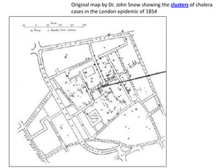
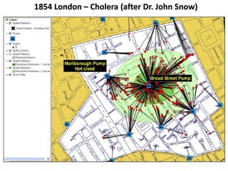
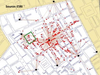
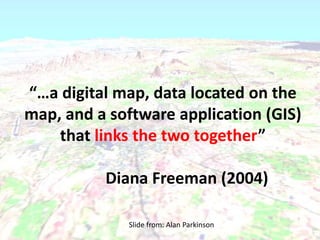
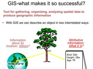
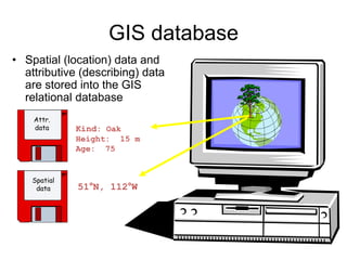
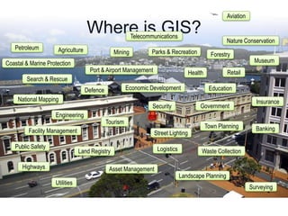
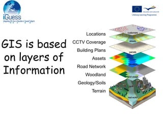
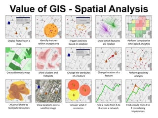
GISGeographical InformationSystems
What is GIGeographical InformationAny information that has a spatial element is Geographical.That is any information that can be located on a map.
Using GI to solve problems – Cholera Epidemic
Original map by Dr. John Snow showing the clusters of cholera cases in the London epidemic of 1854
1854 London – Cholera (after Dr. John Snow)
Source: ESRI
“…a digital map, data located on the map, and a software application (GIS) that links the two together”			Diana Freeman (2004)Slide from: Alan Parkinson
GIS-what makes it so successful?Attributive information:What it is?Information about its location: Where?Kind: OakHeight: 15mAge: 7551°N, 112°WTool for gathering, organizing, analyzing spatial data to produce geographic informationWith GIS we can describe an object in two interrelated ways:
GIS databaseAttr.dataKind: OakHeight:  15mAge:  75Spatialdata51°N, 112°WSpatial (location) data and attributive (describing) data are stored into the GIS relational database
Where is GIS?
Where is GIS?AviationTelecommunicationsNature ConservationPetroleumAgricultureParks & RecreationMiningForestryMuseumCoastal & Marine ProtectionPort & Airport ManagementRetailHealthSearch & RescueEducationEconomic DevelopmentDefenceNational MappingInsuranceGovernmentSecurityEngineeringTourismTown PlanningBankingFacility ManagementStreet LightingPublic SafetyLogisticsLand RegistryWaste CollectionHighwaysAsset ManagementLandscape PlanningUtilitiesSurveying
PropertiesCensus DataHealth StatisticsUtility NetworksPolicy HoldersLand OwnershipFlood RiskRivers/CanalsLocationsCCTV CoverageBuilding PlansAssetsRoad NetworkWoodlandGeology/SoilsTerrainGIS is basedon layers ofInformation
Value of GIS - Spatial AnalysisIdentify features within a target areaPerform comparative time-based analyticsDisplay features on a mapTrigger activities based on locationShow which features are relatedChange location of a featureCreate thematic mapsShow clusters and hotspotsChange the attributesof a featurePerform proximity analysisAnalyse where to reallocate resourcesView locations over a satellite imageAnswer what-if scenariosFind a route from A to B across a networkFind a route from A to B considering impedances

What is GIS?

  • 1.
  • 2.
    What is GIGeographicalInformationAny information that has a spatial element is Geographical.That is any information that can be located on a map.
  • 3.
    Using GI tosolve problems – Cholera Epidemic
  • 4.
    Original map byDr. John Snow showing the clusters of cholera cases in the London epidemic of 1854
  • 5.
    1854 London –Cholera (after Dr. John Snow)
  • 6.
  • 7.
    “…a digital map,data located on the map, and a software application (GIS) that links the two together” Diana Freeman (2004)Slide from: Alan Parkinson
  • 8.
    GIS-what makes itso successful?Attributive information:What it is?Information about its location: Where?Kind: OakHeight: 15mAge: 7551°N, 112°WTool for gathering, organizing, analyzing spatial data to produce geographic informationWith GIS we can describe an object in two interrelated ways:
  • 9.
    GIS databaseAttr.dataKind: OakHeight: 15mAge: 75Spatialdata51°N, 112°WSpatial (location) data and attributive (describing) data are stored into the GIS relational database
  • 10.
  • 11.
    Where is GIS?AviationTelecommunicationsNatureConservationPetroleumAgricultureParks & RecreationMiningForestryMuseumCoastal & Marine ProtectionPort & Airport ManagementRetailHealthSearch & RescueEducationEconomic DevelopmentDefenceNational MappingInsuranceGovernmentSecurityEngineeringTourismTown PlanningBankingFacility ManagementStreet LightingPublic SafetyLogisticsLand RegistryWaste CollectionHighwaysAsset ManagementLandscape PlanningUtilitiesSurveying
  • 12.
    PropertiesCensus DataHealth StatisticsUtilityNetworksPolicy HoldersLand OwnershipFlood RiskRivers/CanalsLocationsCCTV CoverageBuilding PlansAssetsRoad NetworkWoodlandGeology/SoilsTerrainGIS is basedon layers ofInformation
  • 13.
    Value of GIS- Spatial AnalysisIdentify features within a target areaPerform comparative time-based analyticsDisplay features on a mapTrigger activities based on locationShow which features are relatedChange location of a featureCreate thematic mapsShow clusters and hotspotsChange the attributesof a featurePerform proximity analysisAnalyse where to reallocate resourcesView locations over a satellite imageAnswer what-if scenariosFind a route from A to B across a networkFind a route from A to B considering impedances

Editor's Notes

  • #14 GIS is not just about visualisationIt provides powerful analysis capabilities as well.