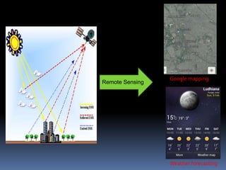
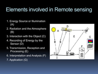
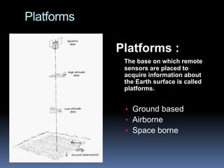
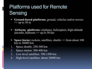
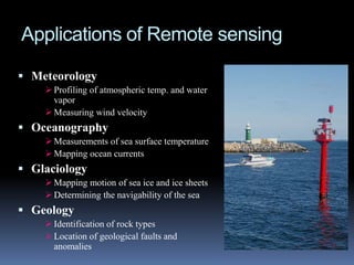
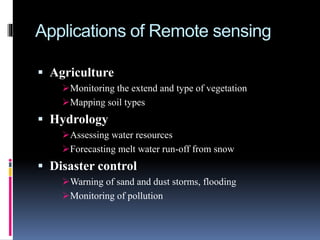
SlideShare a Scribd company logo
REMOTE SENSING
AND ITS APPLICATIONS
Remote Sensing
Weather forecasting
Google mapping
Remote Sensing?
 Remote sensing is defined as the technique
of obtaining information about objects
through the analysis of data collected by
special instruments that are not in physical
contact with the objects of investigation.
 Collection of information about an object
without coming into physical contact.
 The information needs a physical carrier to
travel from the objects/events to the sensors
through an intervening medium.
 The electromagnetic radiation is normally
used as an information carrier in remote
sensing.
 The output of a remote sensing system is
usually an image representing the scene
being observed.
 The technology of modern remote sensing
began with the invention of the camera more
than 150 years ago.
 The idea and practice of looking down at the
Earth's surface emerged in the 1840s when
pictures were taken from cameras secured to
tethered balloons for purposes of topographic
mapping.
 Satellite remote sensing can be traced to the
early days of the space age (both Russian and
American programs) and actually began as a
dual approach to imaging surfaces using
several types of sensors from spacecraft.
 The term "remote sensing," first used in the
United States in the 1950s by Ms. Evelyn
Pruitt of the U.S.
History
Elements involved in Remote sensing
1. Energy Source or Illumination
(A)
2. Radiation and the Atmosphere
(B)
3. Interaction with the Object (C)
4. Recording of Energy by the
Sensor (D)
5. Transmission, Reception and
Processing (E)
6. Interpretation and Analysis (F)
7. Application (G)
Remote Sensing Sensors
 Active Remote Sensors :-
 Active remote sensing uses an artificial source for
energy.
 For example the satellite itself can send a pulse of
energy which can interact with the target.
 In active remote sensing, humans can control the
nature (wavelength, power, duration) of the source
energy. Active remote sensing can be carried out
during day and night and in all weather conditions.
Conti…
Passive remote sensing:-
 Passive remote sensing depends on a natural
source to provide energy.
 For example sun is the most powerful and
commonly used source of energy for passive
remote sensing.
 The satellite sensor in this case records primarily
the radiation that is reflected from the target.
ACTIVE & PASSIVE REMOTE
SENSING
Platforms
Platforms :
The base on which remote
sensors are placed to
acquire information about
the Earth surface is called
platforms.
• Ground based
• Airborne
• Space borne
Platforms used for Remote
Sensing
 Ground-based platforms: ground, vehicles and/or towers
=> up to 50 m
 Airborne platforms: airplanes, helicopters, high-altitude
aircrafts, balloons => up to 50 km
 Space borne: rockets, satellites, shuttle => from about 100
km to 36000 km
1. Space shuttle: 250-300 km
2. Space station: 300-400 km
3. Low-level satellites: 700-1500 km
4. High-level satellites: about 36000 km
Advantages of remote sensing:-
 Provides a regional view (large areas).
 Provides repetitive looks at the same area.
 Remote sensors "see" over a broader.
portion of the spectrum than the human
eye.
 Provides geo-referenced, digital, data.
 Some remote sensors operate in all
seasons, at night, and in bad weather.
DISADVANTAGE OF REMOTE
SENSING:-
 Expensive to build and operate
 Needs ground verification
 Not the best tool for small areas
 Needs expert system to extract data
Applications of Remote sensing
 Meteorology
 Profiling of atmospheric temp. and water
vapor
 Measuring wind velocity
 Oceanography
 Measurements of sea surface temperature
 Mapping ocean currents
 Glaciology
 Mapping motion of sea ice and ice sheets
 Determining the navigability of the sea
 Geology
 Identification of rock types
 Location of geological faults and
anomalies
Applications of Remote sensing
 Agriculture
Monitoring the extend and type of vegetation
Mapping soil types
 Hydrology
Assessing water resources
Forecasting melt water run-off from snow
 Disaster control
Warning of sand and dust storms, flooding
Monitoring of pollution
7528
Thankyou
for
yourkindattention!!!

More Related Content

What's hot

Microwave remote sensing
Microwave remote sensingMicrowave remote sensing
Microwave remote sensing
Mohsin Siddique
 
Remote Sensing and GIS in Land Use / Land Cover Mapping
Remote Sensing and GIS in Land Use / Land Cover MappingRemote Sensing and GIS in Land Use / Land Cover Mapping
Remote Sensing and GIS in Land Use / Land Cover Mapping
VenkatKamal1
 
Chapter 5: Remote sensing
Chapter 5: Remote sensingChapter 5: Remote sensing
Chapter 5: Remote sensing
Shankar Gangaju
 
Introduction to GIS
Introduction to GISIntroduction to GIS
Introduction to GIS
KU Leuven
 
Introduction to Landsat
Introduction to LandsatIntroduction to Landsat
Introduction to Landsat
Nizam GIS
 
Global Positioning System
Global Positioning System Global Positioning System
Global Positioning System
Himanshu Agrawal
 
GIS presentation
GIS presentationGIS presentation
GIS presentation
arniontech
 
Remote sensing - Sensors, Platforms and Satellite orbits
Remote sensing - Sensors, Platforms and Satellite orbitsRemote sensing - Sensors, Platforms and Satellite orbits
Remote sensing - Sensors, Platforms and Satellite orbits
Ajay Singh Lodhi
 
Basics of Remote Sensing
Basics of Remote SensingBasics of Remote Sensing
Basics of Remote Sensing
Akash Tikhe
 
GPS & GIS
GPS & GISGPS & GIS
Visual Interpretation
Visual InterpretationVisual Interpretation
Visual Interpretation
!SYOU co-designed sneakers
 
Geographic information system
Geographic information systemGeographic information system
Geographic information system
Sumanta Das
 
Application of remote sensing
Application of remote sensingApplication of remote sensing
Application of remote sensing
Anurag Kumar
 
Applications of gis
Applications of gisApplications of gis
Applications of gis
Pramoda Raj
 
Remote sensing concept, history and principles
Remote sensing  concept, history and principlesRemote sensing  concept, history and principles
Remote sensing concept, history and principles
Ajay Singh Lodhi
 
Remote sensing - Scanners
Remote sensing - ScannersRemote sensing - Scanners
Remote sensing - Scanners
Pramoda Raj
 
VISUAL IMAGE INTERPRETATION.pptx
VISUAL IMAGE INTERPRETATION.pptxVISUAL IMAGE INTERPRETATION.pptx
VISUAL IMAGE INTERPRETATION.pptx
Samirsinh Parmar
 
Components of Remote Sensing
Components of Remote SensingComponents of Remote Sensing
Components of Remote Sensing
Abby Varghese
 
Remote Sensing Platforms and Sensors
Remote Sensing Platforms and SensorsRemote Sensing Platforms and Sensors
Remote Sensing Platforms and Sensors
Uday kumar Devalla
 
Digital image processing and interpretation
Digital image processing and interpretationDigital image processing and interpretation
Digital image processing and interpretation
P.K. Mani
 

What's hot (20)

Microwave remote sensing
Microwave remote sensingMicrowave remote sensing
Microwave remote sensing
 
Remote Sensing and GIS in Land Use / Land Cover Mapping
Remote Sensing and GIS in Land Use / Land Cover MappingRemote Sensing and GIS in Land Use / Land Cover Mapping
Remote Sensing and GIS in Land Use / Land Cover Mapping
 
Chapter 5: Remote sensing
Chapter 5: Remote sensingChapter 5: Remote sensing
Chapter 5: Remote sensing
 
Introduction to GIS
Introduction to GISIntroduction to GIS
Introduction to GIS
 
Introduction to Landsat
Introduction to LandsatIntroduction to Landsat
Introduction to Landsat
 
Global Positioning System
Global Positioning System Global Positioning System
Global Positioning System
 
GIS presentation
GIS presentationGIS presentation
GIS presentation
 
Remote sensing - Sensors, Platforms and Satellite orbits
Remote sensing - Sensors, Platforms and Satellite orbitsRemote sensing - Sensors, Platforms and Satellite orbits
Remote sensing - Sensors, Platforms and Satellite orbits
 
Basics of Remote Sensing
Basics of Remote SensingBasics of Remote Sensing
Basics of Remote Sensing
 
GPS & GIS
GPS & GISGPS & GIS
GPS & GIS
 
Visual Interpretation
Visual InterpretationVisual Interpretation
Visual Interpretation
 
Geographic information system
Geographic information systemGeographic information system
Geographic information system
 
Application of remote sensing
Application of remote sensingApplication of remote sensing
Application of remote sensing
 
Applications of gis
Applications of gisApplications of gis
Applications of gis
 
Remote sensing concept, history and principles
Remote sensing  concept, history and principlesRemote sensing  concept, history and principles
Remote sensing concept, history and principles
 
Remote sensing - Scanners
Remote sensing - ScannersRemote sensing - Scanners
Remote sensing - Scanners
 
VISUAL IMAGE INTERPRETATION.pptx
VISUAL IMAGE INTERPRETATION.pptxVISUAL IMAGE INTERPRETATION.pptx
VISUAL IMAGE INTERPRETATION.pptx
 
Components of Remote Sensing
Components of Remote SensingComponents of Remote Sensing
Components of Remote Sensing
 
Remote Sensing Platforms and Sensors
Remote Sensing Platforms and SensorsRemote Sensing Platforms and Sensors
Remote Sensing Platforms and Sensors
 
Digital image processing and interpretation
Digital image processing and interpretationDigital image processing and interpretation
Digital image processing and interpretation
 

Viewers also liked

Elements of remote sensing
Elements of remote sensingElements of remote sensing
Elements of remote sensingAlbein Vivek
 
Differential gps (dgps) 09 04-12
Differential gps (dgps) 09 04-12Differential gps (dgps) 09 04-12
Differential gps (dgps) 09 04-12Sumant Diwakar
 
Dgps concept
Dgps conceptDgps concept
Dgps concept
egovindia
 
Carmon remote sensinggis
Carmon remote sensinggisCarmon remote sensinggis
Carmon remote sensinggisnavdeepjamwal
 
Remote Sensing Techniques for Oceanography Satelitte and In Situ Observations
Remote Sensing Techniques for Oceanography Satelitte and In Situ ObservationsRemote Sensing Techniques for Oceanography Satelitte and In Situ Observations
Remote Sensing Techniques for Oceanography Satelitte and In Situ ObservationsA.Tuğsan İşiaçık Çolak
 
GPS
GPS GPS
Global positioning system(GPS)
Global positioning system(GPS)Global positioning system(GPS)
Global positioning system(GPS)
Arghaya Goswami
 
Semiconductor laser
Semiconductor laserSemiconductor laser
Semiconductor laser
Arghaya Goswami
 
Ppt on remote sensing system
Ppt on remote sensing systemPpt on remote sensing system
Ppt on remote sensing systemAlisha Korpal
 
Electromagnetic waves
Electromagnetic wavesElectromagnetic waves
Electromagnetic waves
meenng
 
Electromagnetic Waves Class 12
Electromagnetic Waves Class 12 Electromagnetic Waves Class 12
Electromagnetic Waves Class 12 Self-employed
 
Electromagnetic waves
Electromagnetic wavesElectromagnetic waves
Electromagnetic waves
Jun Libradilla Maloloy-on
 
Electromagnetic waves
Electromagnetic wavesElectromagnetic waves
Electromagnetic waves
KANNAN
 
Electromagnetic waves
Electromagnetic wavesElectromagnetic waves
Electromagnetic wavess7822143g
 
What is GIS
What is GISWhat is GIS
What is GIS
Esri
 
Basic of Remote Sensing
Basic of Remote SensingBasic of Remote Sensing
Basic of Remote Sensing
gueste5cfed
 
REMOTE SENSING
REMOTE SENSINGREMOTE SENSING
REMOTE SENSING
KANNAN
 
The Electromagnetic Spectrum
The Electromagnetic SpectrumThe Electromagnetic Spectrum
The Electromagnetic SpectrumJan Parker
 
electromagnetic spectrum & its uses
 electromagnetic spectrum & its uses  electromagnetic spectrum & its uses
electromagnetic spectrum & its uses
Tarun Joshi
 

Viewers also liked (20)

Elements of remote sensing
Elements of remote sensingElements of remote sensing
Elements of remote sensing
 
remote sensing
remote sensingremote sensing
remote sensing
 
Differential gps (dgps) 09 04-12
Differential gps (dgps) 09 04-12Differential gps (dgps) 09 04-12
Differential gps (dgps) 09 04-12
 
Dgps concept
Dgps conceptDgps concept
Dgps concept
 
Carmon remote sensinggis
Carmon remote sensinggisCarmon remote sensinggis
Carmon remote sensinggis
 
Remote Sensing Techniques for Oceanography Satelitte and In Situ Observations
Remote Sensing Techniques for Oceanography Satelitte and In Situ ObservationsRemote Sensing Techniques for Oceanography Satelitte and In Situ Observations
Remote Sensing Techniques for Oceanography Satelitte and In Situ Observations
 
GPS
GPS GPS
GPS
 
Global positioning system(GPS)
Global positioning system(GPS)Global positioning system(GPS)
Global positioning system(GPS)
 
Semiconductor laser
Semiconductor laserSemiconductor laser
Semiconductor laser
 
Ppt on remote sensing system
Ppt on remote sensing systemPpt on remote sensing system
Ppt on remote sensing system
 
Electromagnetic waves
Electromagnetic wavesElectromagnetic waves
Electromagnetic waves
 
Electromagnetic Waves Class 12
Electromagnetic Waves Class 12 Electromagnetic Waves Class 12
Electromagnetic Waves Class 12
 
Electromagnetic waves
Electromagnetic wavesElectromagnetic waves
Electromagnetic waves
 
Electromagnetic waves
Electromagnetic wavesElectromagnetic waves
Electromagnetic waves
 
Electromagnetic waves
Electromagnetic wavesElectromagnetic waves
Electromagnetic waves
 
What is GIS
What is GISWhat is GIS
What is GIS
 
Basic of Remote Sensing
Basic of Remote SensingBasic of Remote Sensing
Basic of Remote Sensing
 
REMOTE SENSING
REMOTE SENSINGREMOTE SENSING
REMOTE SENSING
 
The Electromagnetic Spectrum
The Electromagnetic SpectrumThe Electromagnetic Spectrum
The Electromagnetic Spectrum
 
electromagnetic spectrum & its uses
 electromagnetic spectrum & its uses  electromagnetic spectrum & its uses
electromagnetic spectrum & its uses
 

Similar to Remote sensing ppt

Module 5 Remote Sensing in Civil Engineering.pptx
Module 5 Remote Sensing in Civil Engineering.pptxModule 5 Remote Sensing in Civil Engineering.pptx
Module 5 Remote Sensing in Civil Engineering.pptx
surekha1287
 
Remote sensing
Remote sensingRemote sensing
Remote sensing
pavithrasenthilkumar5
 
remote sensing
remote sensingremote sensing
remote sensing
78harshith
 
Remote Sensing_2020-21 (1).pdf
Remote Sensing_2020-21  (1).pdfRemote Sensing_2020-21  (1).pdf
Remote Sensing_2020-21 (1).pdf
BAGARAGAZAROMUALD2
 
Remote sensing
Remote sensingRemote sensing
Remote sensing
KHUSHBU SHAH
 
REMOTE SENSING........btech civil ..pptx
REMOTE SENSING........btech civil ..pptxREMOTE SENSING........btech civil ..pptx
REMOTE SENSING........btech civil ..pptx
Ayushsharma131736
 
Ch 5 b remote sensing
Ch 5 b remote sensingCh 5 b remote sensing
Remote sensing
Remote sensingRemote sensing
Remote sensing
Anand Choudhary
 
Concepts of Remote Sensing: Process and Stages of Remote Sensing, Remote Sens...
Concepts of Remote Sensing: Process and Stages of Remote Sensing, Remote Sens...Concepts of Remote Sensing: Process and Stages of Remote Sensing, Remote Sens...
Concepts of Remote Sensing: Process and Stages of Remote Sensing, Remote Sens...
ShavnamMehta
 
Concept of remote sensing
Concept of remote sensingConcept of remote sensing
Concept of remote sensing
UTTAM KUMAR PARIDA
 
Remote sensing and its applications in environment
Remote sensing and its applications in environmentRemote sensing and its applications in environment
Remote sensing and its applications in environmentMuhammad Sajjad
 
Remote Sensing - by Ashwini
Remote Sensing - by AshwiniRemote Sensing - by Ashwini
Remote Sensing - by AshwiniSanthosh Sundar
 
remote sensing for study.docx
remote sensing for study.docxremote sensing for study.docx
remote sensing for study.docx
bbc37142
 
rsgis-unitii-160731062950.pdf
rsgis-unitii-160731062950.pdfrsgis-unitii-160731062950.pdf
rsgis-unitii-160731062950.pdf
BSuresh26
 
Report
ReportReport
Report
ALIN BABU
 
Introduction to Remote Sensing
Introduction to Remote SensingIntroduction to Remote Sensing
Introduction to Remote Sensing
Malla Reddy University
 
intro.pptx
intro.pptxintro.pptx
Remote sensing by Priyanshu kumar, 9608684800
Remote sensing by Priyanshu kumar, 9608684800Remote sensing by Priyanshu kumar, 9608684800
Remote sensing by Priyanshu kumar, 9608684800
PRIYANSHU KUMAR
 
Basic Understanding of Remote Sensing.pdf
Basic Understanding of Remote Sensing.pdfBasic Understanding of Remote Sensing.pdf
Basic Understanding of Remote Sensing.pdf
rupalibgisnetra
 
A Brief Introduction to Remote Sensing Satellites
A Brief Introduction to Remote Sensing Satellites A Brief Introduction to Remote Sensing Satellites
A Brief Introduction to Remote Sensing Satellites
Alireza Rahimzadeganasl
 

Similar to Remote sensing ppt (20)

Module 5 Remote Sensing in Civil Engineering.pptx
Module 5 Remote Sensing in Civil Engineering.pptxModule 5 Remote Sensing in Civil Engineering.pptx
Module 5 Remote Sensing in Civil Engineering.pptx
 
Remote sensing
Remote sensingRemote sensing
Remote sensing
 
remote sensing
remote sensingremote sensing
remote sensing
 
Remote Sensing_2020-21 (1).pdf
Remote Sensing_2020-21  (1).pdfRemote Sensing_2020-21  (1).pdf
Remote Sensing_2020-21 (1).pdf
 
Remote sensing
Remote sensingRemote sensing
Remote sensing
 
REMOTE SENSING........btech civil ..pptx
REMOTE SENSING........btech civil ..pptxREMOTE SENSING........btech civil ..pptx
REMOTE SENSING........btech civil ..pptx
 
Ch 5 b remote sensing
Ch 5 b remote sensingCh 5 b remote sensing
Ch 5 b remote sensing
 
Remote sensing
Remote sensingRemote sensing
Remote sensing
 
Concepts of Remote Sensing: Process and Stages of Remote Sensing, Remote Sens...
Concepts of Remote Sensing: Process and Stages of Remote Sensing, Remote Sens...Concepts of Remote Sensing: Process and Stages of Remote Sensing, Remote Sens...
Concepts of Remote Sensing: Process and Stages of Remote Sensing, Remote Sens...
 
Concept of remote sensing
Concept of remote sensingConcept of remote sensing
Concept of remote sensing
 
Remote sensing and its applications in environment
Remote sensing and its applications in environmentRemote sensing and its applications in environment
Remote sensing and its applications in environment
 
Remote Sensing - by Ashwini
Remote Sensing - by AshwiniRemote Sensing - by Ashwini
Remote Sensing - by Ashwini
 
remote sensing for study.docx
remote sensing for study.docxremote sensing for study.docx
remote sensing for study.docx
 
rsgis-unitii-160731062950.pdf
rsgis-unitii-160731062950.pdfrsgis-unitii-160731062950.pdf
rsgis-unitii-160731062950.pdf
 
Report
ReportReport
Report
 
Introduction to Remote Sensing
Introduction to Remote SensingIntroduction to Remote Sensing
Introduction to Remote Sensing
 
intro.pptx
intro.pptxintro.pptx
intro.pptx
 
Remote sensing by Priyanshu kumar, 9608684800
Remote sensing by Priyanshu kumar, 9608684800Remote sensing by Priyanshu kumar, 9608684800
Remote sensing by Priyanshu kumar, 9608684800
 
Basic Understanding of Remote Sensing.pdf
Basic Understanding of Remote Sensing.pdfBasic Understanding of Remote Sensing.pdf
Basic Understanding of Remote Sensing.pdf
 
A Brief Introduction to Remote Sensing Satellites
A Brief Introduction to Remote Sensing Satellites A Brief Introduction to Remote Sensing Satellites
A Brief Introduction to Remote Sensing Satellites
 

Recently uploaded

Mule 4.6 & Java 17 Upgrade | MuleSoft Mysore Meetup #46
Mule 4.6 & Java 17 Upgrade | MuleSoft Mysore Meetup #46Mule 4.6 & Java 17 Upgrade | MuleSoft Mysore Meetup #46
Mule 4.6 & Java 17 Upgrade | MuleSoft Mysore Meetup #46
MysoreMuleSoftMeetup
 
Synthetic Fiber Construction in lab .pptx
Synthetic Fiber Construction in lab .pptxSynthetic Fiber Construction in lab .pptx
Synthetic Fiber Construction in lab .pptx
Pavel ( NSTU)
 
GIÁO ÁN DẠY THÊM (KẾ HOẠCH BÀI BUỔI 2) - TIẾNG ANH 8 GLOBAL SUCCESS (2 CỘT) N...
GIÁO ÁN DẠY THÊM (KẾ HOẠCH BÀI BUỔI 2) - TIẾNG ANH 8 GLOBAL SUCCESS (2 CỘT) N...GIÁO ÁN DẠY THÊM (KẾ HOẠCH BÀI BUỔI 2) - TIẾNG ANH 8 GLOBAL SUCCESS (2 CỘT) N...
GIÁO ÁN DẠY THÊM (KẾ HOẠCH BÀI BUỔI 2) - TIẾNG ANH 8 GLOBAL SUCCESS (2 CỘT) N...
Nguyen Thanh Tu Collection
 
Operation Blue Star - Saka Neela Tara
Operation Blue Star   -  Saka Neela TaraOperation Blue Star   -  Saka Neela Tara
Operation Blue Star - Saka Neela Tara
Balvir Singh
 
The approach at University of Liverpool.pptx
The approach at University of Liverpool.pptxThe approach at University of Liverpool.pptx
The approach at University of Liverpool.pptx
Jisc
 
The geography of Taylor Swift - some ideas
The geography of Taylor Swift - some ideasThe geography of Taylor Swift - some ideas
The geography of Taylor Swift - some ideas
GeoBlogs
 
How to Make a Field invisible in Odoo 17
How to Make a Field invisible in Odoo 17How to Make a Field invisible in Odoo 17
How to Make a Field invisible in Odoo 17
Celine George
 
Sectors of the Indian Economy - Class 10 Study Notes pdf
Sectors of the Indian Economy - Class 10 Study Notes pdfSectors of the Indian Economy - Class 10 Study Notes pdf
Sectors of the Indian Economy - Class 10 Study Notes pdf
Vivekanand Anglo Vedic Academy
 
MARUTI SUZUKI- A Successful Joint Venture in India.pptx
MARUTI SUZUKI- A Successful Joint Venture in India.pptxMARUTI SUZUKI- A Successful Joint Venture in India.pptx
MARUTI SUZUKI- A Successful Joint Venture in India.pptx
bennyroshan06
 
PART A. Introduction to Costumer Service
PART A. Introduction to Costumer ServicePART A. Introduction to Costumer Service
PART A. Introduction to Costumer Service
PedroFerreira53928
 
ESC Beyond Borders _From EU to You_ InfoPack general.pdf
ESC Beyond Borders _From EU to You_ InfoPack general.pdfESC Beyond Borders _From EU to You_ InfoPack general.pdf
ESC Beyond Borders _From EU to You_ InfoPack general.pdf
Fundacja Rozwoju Społeczeństwa Przedsiębiorczego
 
Introduction to Quality Improvement Essentials
Introduction to Quality Improvement EssentialsIntroduction to Quality Improvement Essentials
Introduction to Quality Improvement Essentials
Excellence Foundation for South Sudan
 
Polish students' mobility in the Czech Republic
Polish students' mobility in the Czech RepublicPolish students' mobility in the Czech Republic
Polish students' mobility in the Czech Republic
Anna Sz.
 
The Challenger.pdf DNHS Official Publication
The Challenger.pdf DNHS Official PublicationThe Challenger.pdf DNHS Official Publication
The Challenger.pdf DNHS Official Publication
Delapenabediema
 
Palestine last event orientationfvgnh .pptx
Palestine last event orientationfvgnh .pptxPalestine last event orientationfvgnh .pptx
Palestine last event orientationfvgnh .pptx
RaedMohamed3
 
Model Attribute Check Company Auto Property
Model Attribute  Check Company Auto PropertyModel Attribute  Check Company Auto Property
Model Attribute Check Company Auto Property
Celine George
 
Home assignment II on Spectroscopy 2024 Answers.pdf
Home assignment II on Spectroscopy 2024 Answers.pdfHome assignment II on Spectroscopy 2024 Answers.pdf
Home assignment II on Spectroscopy 2024 Answers.pdf
Tamralipta Mahavidyalaya
 
Ethnobotany and Ethnopharmacology ......
Ethnobotany and Ethnopharmacology ......Ethnobotany and Ethnopharmacology ......
Ethnobotany and Ethnopharmacology ......
Ashokrao Mane college of Pharmacy Peth-Vadgaon
 
Overview on Edible Vaccine: Pros & Cons with Mechanism
Overview on Edible Vaccine: Pros & Cons with MechanismOverview on Edible Vaccine: Pros & Cons with Mechanism
Overview on Edible Vaccine: Pros & Cons with Mechanism
DeeptiGupta154
 
The Roman Empire A Historical Colossus.pdf
The Roman Empire A Historical Colossus.pdfThe Roman Empire A Historical Colossus.pdf
The Roman Empire A Historical Colossus.pdf
kaushalkr1407
 

Recently uploaded (20)

Mule 4.6 & Java 17 Upgrade | MuleSoft Mysore Meetup #46
Mule 4.6 & Java 17 Upgrade | MuleSoft Mysore Meetup #46Mule 4.6 & Java 17 Upgrade | MuleSoft Mysore Meetup #46
Mule 4.6 & Java 17 Upgrade | MuleSoft Mysore Meetup #46
 
Synthetic Fiber Construction in lab .pptx
Synthetic Fiber Construction in lab .pptxSynthetic Fiber Construction in lab .pptx
Synthetic Fiber Construction in lab .pptx
 
GIÁO ÁN DẠY THÊM (KẾ HOẠCH BÀI BUỔI 2) - TIẾNG ANH 8 GLOBAL SUCCESS (2 CỘT) N...
GIÁO ÁN DẠY THÊM (KẾ HOẠCH BÀI BUỔI 2) - TIẾNG ANH 8 GLOBAL SUCCESS (2 CỘT) N...GIÁO ÁN DẠY THÊM (KẾ HOẠCH BÀI BUỔI 2) - TIẾNG ANH 8 GLOBAL SUCCESS (2 CỘT) N...
GIÁO ÁN DẠY THÊM (KẾ HOẠCH BÀI BUỔI 2) - TIẾNG ANH 8 GLOBAL SUCCESS (2 CỘT) N...
 
Operation Blue Star - Saka Neela Tara
Operation Blue Star   -  Saka Neela TaraOperation Blue Star   -  Saka Neela Tara
Operation Blue Star - Saka Neela Tara
 
The approach at University of Liverpool.pptx
The approach at University of Liverpool.pptxThe approach at University of Liverpool.pptx
The approach at University of Liverpool.pptx
 
The geography of Taylor Swift - some ideas
The geography of Taylor Swift - some ideasThe geography of Taylor Swift - some ideas
The geography of Taylor Swift - some ideas
 
How to Make a Field invisible in Odoo 17
How to Make a Field invisible in Odoo 17How to Make a Field invisible in Odoo 17
How to Make a Field invisible in Odoo 17
 
Sectors of the Indian Economy - Class 10 Study Notes pdf
Sectors of the Indian Economy - Class 10 Study Notes pdfSectors of the Indian Economy - Class 10 Study Notes pdf
Sectors of the Indian Economy - Class 10 Study Notes pdf
 
MARUTI SUZUKI- A Successful Joint Venture in India.pptx
MARUTI SUZUKI- A Successful Joint Venture in India.pptxMARUTI SUZUKI- A Successful Joint Venture in India.pptx
MARUTI SUZUKI- A Successful Joint Venture in India.pptx
 
PART A. Introduction to Costumer Service
PART A. Introduction to Costumer ServicePART A. Introduction to Costumer Service
PART A. Introduction to Costumer Service
 
ESC Beyond Borders _From EU to You_ InfoPack general.pdf
ESC Beyond Borders _From EU to You_ InfoPack general.pdfESC Beyond Borders _From EU to You_ InfoPack general.pdf
ESC Beyond Borders _From EU to You_ InfoPack general.pdf
 
Introduction to Quality Improvement Essentials
Introduction to Quality Improvement EssentialsIntroduction to Quality Improvement Essentials
Introduction to Quality Improvement Essentials
 
Polish students' mobility in the Czech Republic
Polish students' mobility in the Czech RepublicPolish students' mobility in the Czech Republic
Polish students' mobility in the Czech Republic
 
The Challenger.pdf DNHS Official Publication
The Challenger.pdf DNHS Official PublicationThe Challenger.pdf DNHS Official Publication
The Challenger.pdf DNHS Official Publication
 
Palestine last event orientationfvgnh .pptx
Palestine last event orientationfvgnh .pptxPalestine last event orientationfvgnh .pptx
Palestine last event orientationfvgnh .pptx
 
Model Attribute Check Company Auto Property
Model Attribute  Check Company Auto PropertyModel Attribute  Check Company Auto Property
Model Attribute Check Company Auto Property
 
Home assignment II on Spectroscopy 2024 Answers.pdf
Home assignment II on Spectroscopy 2024 Answers.pdfHome assignment II on Spectroscopy 2024 Answers.pdf
Home assignment II on Spectroscopy 2024 Answers.pdf
 
Ethnobotany and Ethnopharmacology ......
Ethnobotany and Ethnopharmacology ......Ethnobotany and Ethnopharmacology ......
Ethnobotany and Ethnopharmacology ......
 
Overview on Edible Vaccine: Pros & Cons with Mechanism
Overview on Edible Vaccine: Pros & Cons with MechanismOverview on Edible Vaccine: Pros & Cons with Mechanism
Overview on Edible Vaccine: Pros & Cons with Mechanism
 
The Roman Empire A Historical Colossus.pdf
The Roman Empire A Historical Colossus.pdfThe Roman Empire A Historical Colossus.pdf
The Roman Empire A Historical Colossus.pdf
 

Remote sensing ppt

  • 1. REMOTE SENSING AND ITS APPLICATIONS
  • 3. Remote Sensing?  Remote sensing is defined as the technique of obtaining information about objects through the analysis of data collected by special instruments that are not in physical contact with the objects of investigation.  Collection of information about an object without coming into physical contact.  The information needs a physical carrier to travel from the objects/events to the sensors through an intervening medium.  The electromagnetic radiation is normally used as an information carrier in remote sensing.  The output of a remote sensing system is usually an image representing the scene being observed.
  • 4.  The technology of modern remote sensing began with the invention of the camera more than 150 years ago.  The idea and practice of looking down at the Earth's surface emerged in the 1840s when pictures were taken from cameras secured to tethered balloons for purposes of topographic mapping.  Satellite remote sensing can be traced to the early days of the space age (both Russian and American programs) and actually began as a dual approach to imaging surfaces using several types of sensors from spacecraft.  The term "remote sensing," first used in the United States in the 1950s by Ms. Evelyn Pruitt of the U.S. History
  • 5. Elements involved in Remote sensing 1. Energy Source or Illumination (A) 2. Radiation and the Atmosphere (B) 3. Interaction with the Object (C) 4. Recording of Energy by the Sensor (D) 5. Transmission, Reception and Processing (E) 6. Interpretation and Analysis (F) 7. Application (G)
  • 6. Remote Sensing Sensors  Active Remote Sensors :-  Active remote sensing uses an artificial source for energy.  For example the satellite itself can send a pulse of energy which can interact with the target.  In active remote sensing, humans can control the nature (wavelength, power, duration) of the source energy. Active remote sensing can be carried out during day and night and in all weather conditions.
  • 7. Conti… Passive remote sensing:-  Passive remote sensing depends on a natural source to provide energy.  For example sun is the most powerful and commonly used source of energy for passive remote sensing.  The satellite sensor in this case records primarily the radiation that is reflected from the target.
  • 8. ACTIVE & PASSIVE REMOTE SENSING
  • 9. Platforms Platforms : The base on which remote sensors are placed to acquire information about the Earth surface is called platforms. • Ground based • Airborne • Space borne
  • 10. Platforms used for Remote Sensing  Ground-based platforms: ground, vehicles and/or towers => up to 50 m  Airborne platforms: airplanes, helicopters, high-altitude aircrafts, balloons => up to 50 km  Space borne: rockets, satellites, shuttle => from about 100 km to 36000 km 1. Space shuttle: 250-300 km 2. Space station: 300-400 km 3. Low-level satellites: 700-1500 km 4. High-level satellites: about 36000 km
  • 11. Advantages of remote sensing:-  Provides a regional view (large areas).  Provides repetitive looks at the same area.  Remote sensors "see" over a broader. portion of the spectrum than the human eye.  Provides geo-referenced, digital, data.  Some remote sensors operate in all seasons, at night, and in bad weather.
  • 12. DISADVANTAGE OF REMOTE SENSING:-  Expensive to build and operate  Needs ground verification  Not the best tool for small areas  Needs expert system to extract data
  • 13. Applications of Remote sensing  Meteorology  Profiling of atmospheric temp. and water vapor  Measuring wind velocity  Oceanography  Measurements of sea surface temperature  Mapping ocean currents  Glaciology  Mapping motion of sea ice and ice sheets  Determining the navigability of the sea  Geology  Identification of rock types  Location of geological faults and anomalies
  • 14. Applications of Remote sensing  Agriculture Monitoring the extend and type of vegetation Mapping soil types  Hydrology Assessing water resources Forecasting melt water run-off from snow  Disaster control Warning of sand and dust storms, flooding Monitoring of pollution