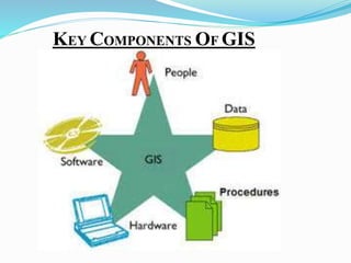
SlideShare a Scribd company logo
1 of 38
GANDHINAGAR INSTITUTE OF 
TECHNOLOGY 
Elements of Civil Engineering 
Presentation on 
“Geographical Information System” 
Prepared By:- 
Vedant Dave 140120119247 
Vivek Verma 140120119248 
Kuldeep Tiwari 140120119233 
Prahar Vyas 140120119251 
Nilesh Sharma 140120119215 
Guided By:- 
Mrs. Priyanka Mehta 
Mrs. Ankita Shah
Flow of Presentation 
1. Introduction to GIS 
2. History of Development 
3. Key Components of GIS 
4. GIS Processes 
5. 4 M’s of GIS 
6. Contribution Disciplines of GIS 
7. Applications of GIS 
8. Research Papers
Introduction to GIS 
GEOGRAPHIC 
implies that locations of the data items are known, or can be 
calculated, in terms of Geographic coordinates (Latitude, 
Longitude) 
INFORMATION 
implies that the data in a GIS are organized to yield useful 
knowledge, often as colored maps and images, but also as statistical 
graphics, tables, and various on-screen responses to interactive 
queries. 
SYSTEM 
implies that a GIS is made up from several inter-related and linked 
components with different functions. Thus, GIS have functional 
capabilities for data capture, input, manipulation, transformation, 
visualization, combinations, query, analysis, modelling and output.
A Model of GIS
• Allow users to create interactive queries. 
• Analyze spatial information 
• Edit data in maps. 
• Geographic concepts, applications, and systems. 
• Refers to a number of different technologies, processes, 
and methods. 
• Foundation for many location-enabled services that rely 
on analysis and visualization. 
• Relate unrelated information. 
• RecordsLocations or extents in the Earth space–time.
The x, y and z axis representating the longitude, latitude, 
and elevation, respectively
History of Development 
• John Snow's 1855 map of the Soho cholera in the London. 
 1966 GIS demonstrated by Howard 
Fisher 
 1969 ESRI founded 
 1970’s satellites aid GPS 
 1971 GIS project used a layering 
system to display data 
 1979 Odessy developed
GIS concepts 
 London cholera epidemic 1854 
8 
Soho 
+ 
Cholera death 
Water pump
 1986 MapInfo developed 
 1986 SPOT satellite was launched. 
 1992 the Lebanon used GIS to 
rebuild electricity network the
KEY COMPONENTS OF GIS
1. Hardware:- 
• Used in stand-alone or networked configurations. 
• Chief part of GIS such as Computer etc. 
• Help to run centralized computer servers to desktop 
2. Software:- 
•Analyse and display geographic information. 
•Provides function and tools needed. 
3. Data:- 
•Collects the geographic and other tabular data 
•It assemble to use specifications and requirements 
•Integrate spatial data with other existing data resources 
•Key functionality is to store the data.
4.People:- 
• Developers and users are quiet important. 
• Ranges from Specialists to Normal Users. 
5. Procedures:- 
• Drafting Designs 
• Implementing Plans 
• Integration into the business strategy and operation 
• Requires necessary investments in hardware and 
software
Capture 
Data 
GIS Process 
Register 
Map Base 
Interpret 
Data 
Convert Data 
to Digital 
Format 
Store Data 
in Computer 
Process 
Data 
Display 
Results
4 M’s of GIS
Land Use Environmental 
Cadastral 4 M’s 
Assessment 
Agriculture Drainage Network 
Hydrology Model Terrains 
Measurement 
Mapping 
Monitoring 
Modelling
Contribution Disciplines
Mathematics 
GIS 
Geography 
Cartography 
CAD,CAM 
Automated 
Cartography 
Surveying 
Photographical 
Digital 
Photogrammetry 
Remote Sensing 
Technology 
Statistics
Applications of GIS 
1. Agriculture 
 Farm management 
 Pest/Disease tracking 
 Crop monitoring 
 Yield prediction 
 Soil analysis
2. Natural Resource Management 
 Forestry 
 Ecology 
 Mining 
 Petroleum 
 Water Resources
3.Planning and Economic Development 
 Land Use/Zoning 
 Emergency Preparedness 
 Population Forecast 
 Market Analysis 
 Property Tax Assessment 
 Transportation
4. Geography Matters 
Today’s challenges require geographic approach 
 Climate Change 
 Urban Growth 
 Sustainable Agriculture 
 Water Quality and Availability 
 International and National Security 
 Energy 
 Epidemiology/Disease Tracking 
 Natural Hazards: Seismicity, Weather Events
5.Vehicle Routing
6. Land Use Planning and Management 
Map of Ahmedabad City through GIS
7.Environmental Applications 
• Land cover and land use analysis 
• Modelling watersheds 
• Soil Erosion 
• Forest management 
• Conservation and Protected Areas 
Marine Map
8.Business Applications 
• Delivery of goods and services 
• Retail store placement 
• Distribution of competitors 
• Location of potential customers 
• Traffic flow 
• Parking locations
Expenditures using costumer market data
Literature Review 
L 
TOPIC:- 
An overview of 
“Geographic Information 
System" and its role and 
applicability in 
Environmental 
Monitoring and Process 
Modelling 
Author:- 
Miroslav Rusko, 
Roman Chovanec, 
Dana Roskova 
Volume 29 
Edition :- 1st 
Year:- 2010 
Methodology Used:- Result/Conclusion:- 
GIS system are the powerful 
and effective tool for creating 
intelligent maps. The system 
functions only when the 
requisite expertise is available, 
the data are compiled, the 
necessary routines are 
organized, and the programs are 
modified to suit the application, 
and/or the organization’s needs. 
GIS integrates all kinds of 
information and applications 
with a geographic component 
into one manageable system. 
The hardware and software 
functions of GIS include:- 
• Data input 
• Data storage 
• Data management (data 
manipulation, updating, 
changing, exchange) 
• Data reporting (retrieval, 
presentation, analysis, 
combination, etc.). 
All of these actions and 
operations are applied to 
GIS as a tool that forms its 
database.
Literature Review 
L 
TOPIC:- 
Developing a Web-based 
GIS Application 
for Earthquake 
Information 
Author :- 
A. Garagon Dogru , 
T. Selcuk , 
H. Ozener, 
O. Gurkan, G. Toz 
Volume 1 
Edition :- 1st 
Year:- NA 
Methodology Used:- Result/Conclusion:- 
It is designed to allow viewing, 
querying, and analysis of 
geographic information. This 
application is a software 
independent System. It offers 
maximum functionality with the 
minimum effort. The drawback 
in such a distributed system is 
that data come 
from different sources based on 
different forms and datas 
which cause havoc in a GIS. The 
response time for generating 
maps is related to the map server 
configuration (memory, disk, and 
processor). 
This paper focuses on 
development and 
implementation of a web-based 
GIS application for 
earthquake information. 
Methods used:- 
• Integrating various data from 
different sources. 
• Provides public users to 
access information. 
• Gathers information about 
Earthquakes doing spatial 
and attribute query. 
• Easy data management 
including maintenance and 
updating.
Literature Review 
L 
TOPIC:- 
GIS Technology for 
Disasters 
and Emergency 
Management 
Author :- 
Russ Johnson 
Volume 1 
Edition :- 1st 
Year:- May 2000 
Methodology Used:- Result/Conclusion:- 
This paper will identify 
emergency management 
activities and describe how 
GIS technology plays a 
critically important role. 
Methods Used:- 
• Information analysis 
• Mapping 
• Emergency management 
planning 
• Planning Implementation 
• Modifications in Planning 
•Data Reporting 
GIS allows emergency 
management needs to be 
identified prior to an incident. 
Emergency management 
personnel can use modeling for 
training, for actual tactical 
deployment during a disaster, 
or to analyze the consequences 
of a possible disaster. In short, 
the thoughtful application of a 
GIS can take 
much of the panic and surprise 
out of emergencies.
Literature Review 
TOPIC:- 
GIS and Transportation: 
Status and Challenges 
It is designed to allow viewing, querying, and analysis 
of geographic information. 
Author:- 
Michael F. 
Goodchild 
Volume 1 
Edition :- 1st 
Methodology Used:- Result/Conclusion:- 
Database designs have been 
influenced by a number of 
historical practices and 
traditions, and three of these 
have been of particular 
significance to GIS: map, 
navigation, and the study of 
behavior. Six research 
challenges have been 
identified, ranging from the 
technical issues of 
representation and unambiguous 
communication of location to 
the economic modeling of GIS 
data creation and use. 
The application of GIS in 
transportation, dates from 
the very earliest in the 1960s. 
Methods Used:- 
• The mapping 
• The navigation 
• Unambiguous 
communication 
• Connectivity 
• Response to new 
technologies 
• Map Implementation 
• Map Recovery
References 
Websites:- 
www.google.com 
www.wikipedia.org 
www.mtf.stuba.sk 
ncgia.ucsb.edu 
www.isprs.org 
Journals:- 
Research Papers Authors 
GIS and its role and applicability in 
Environmental Monitoring and 
Process Modelling 
Developing a Web-based GIS 
Application for Earthquake Info. 
GIS Technology for Disasters and 
Emergency Management 
GIS and Transportation: Status and 
Challenges 
Miroslav Rusko, Roman Chovanec, 
Dana Roskova 
A. Garagon Dogru , T. Selcuk , 
H. Ozener, O. Gurkan, G. Toz 
Russ Johnson 
Michael F. Goodchild 
1. 
2. 
3. 
4. 
Books:- 
R.B.Khasiya
Gis powerpoint

More Related Content

What's hot

What's hot (20)

Mobile gis
Mobile gisMobile gis
Mobile gis
 
Functions of GIS
Functions of GISFunctions of GIS
Functions of GIS
 
Introduction to GIS
Introduction to GISIntroduction to GIS
Introduction to GIS
 
Urban Landuse/ Landcover change analysis using Remote Sensing and GIS
Urban Landuse/ Landcover change analysis using Remote Sensing and GISUrban Landuse/ Landcover change analysis using Remote Sensing and GIS
Urban Landuse/ Landcover change analysis using Remote Sensing and GIS
 
Introduction to GIS
Introduction to GISIntroduction to GIS
Introduction to GIS
 
DATA in GIS and DATA Query
DATA in GIS and DATA QueryDATA in GIS and DATA Query
DATA in GIS and DATA Query
 
GIS
GISGIS
GIS
 
Gis functions
Gis functionsGis functions
Gis functions
 
Gis Geographical Information System Fundamentals
Gis Geographical Information System FundamentalsGis Geographical Information System Fundamentals
Gis Geographical Information System Fundamentals
 
Basics of Remote Sensing
Basics of Remote SensingBasics of Remote Sensing
Basics of Remote Sensing
 
Gis
GisGis
Gis
 
Principles of GIS unit 1
Principles of GIS unit 1Principles of GIS unit 1
Principles of GIS unit 1
 
Presentation on gis and future trends
Presentation on gis and future trendsPresentation on gis and future trends
Presentation on gis and future trends
 
Introduction to GIS
Introduction to GISIntroduction to GIS
Introduction to GIS
 
Digital Elevation Model (DEM)
Digital Elevation Model (DEM)Digital Elevation Model (DEM)
Digital Elevation Model (DEM)
 
gis
gisgis
gis
 
Chapter one gis
Chapter one gisChapter one gis
Chapter one gis
 
Basic of gis concept and theories
Basic of gis concept and theoriesBasic of gis concept and theories
Basic of gis concept and theories
 
Application of GIS and RS in Watershed Management
Application of GIS and RS in Watershed ManagementApplication of GIS and RS in Watershed Management
Application of GIS and RS in Watershed Management
 
Data base management system
Data base management systemData base management system
Data base management system
 

Similar to Gis powerpoint

Introduction to Geographic Information System.pptx
Introduction to Geographic Information System.pptxIntroduction to Geographic Information System.pptx
Introduction to Geographic Information System.pptxElijahEmmanuel6
 
INTRODUCTION TO GIS
INTRODUCTION TO GISINTRODUCTION TO GIS
INTRODUCTION TO GISHamzaAhmad91
 
GIS for geophysics.pptx
GIS for geophysics.pptxGIS for geophysics.pptx
GIS for geophysics.pptxThomasHundasa1
 
Fundamentals of gis
Fundamentals of gisFundamentals of gis
Fundamentals of gisJessy Mol
 
TYBSC IT PGIS Unit I Chapter I- Introduction to Geographic Information Systems
TYBSC IT PGIS Unit I  Chapter I- Introduction to Geographic Information SystemsTYBSC IT PGIS Unit I  Chapter I- Introduction to Geographic Information Systems
TYBSC IT PGIS Unit I Chapter I- Introduction to Geographic Information SystemsArti Parab Academics
 
EVS G.I.S CONCEPTS OF SCIENCE PPT.pptx
EVS  G.I.S CONCEPTS  OF SCIENCE PPT.pptxEVS  G.I.S CONCEPTS  OF SCIENCE PPT.pptx
EVS G.I.S CONCEPTS OF SCIENCE PPT.pptxUMANJUNATH
 
Geographical information system
Geographical information systemGeographical information system
Geographical information systemBipin Karki
 
Geographical information system
Geographical information systemGeographical information system
Geographical information systemBipin Karki
 
GEOGRAPHICAL INFORMATION SYSTEM (GIS)
GEOGRAPHICAL INFORMATION SYSTEM (GIS)GEOGRAPHICAL INFORMATION SYSTEM (GIS)
GEOGRAPHICAL INFORMATION SYSTEM (GIS)subhashB10
 

Similar to Gis powerpoint (20)

GIS.pptx
GIS.pptxGIS.pptx
GIS.pptx
 
Introduction to Geographic Information System.pptx
Introduction to Geographic Information System.pptxIntroduction to Geographic Information System.pptx
Introduction to Geographic Information System.pptx
 
FINAL 31,12,10
FINAL 31,12,10FINAL 31,12,10
FINAL 31,12,10
 
Gis
GisGis
Gis
 
GIS in Civil Engineering
GIS in Civil EngineeringGIS in Civil Engineering
GIS in Civil Engineering
 
GISgIRR G1.pptx
GISgIRR G1.pptxGISgIRR G1.pptx
GISgIRR G1.pptx
 
INTRODUCTION TO GIS
INTRODUCTION TO GISINTRODUCTION TO GIS
INTRODUCTION TO GIS
 
gis.pdf
gis.pdfgis.pdf
gis.pdf
 
gis.pdf
gis.pdfgis.pdf
gis.pdf
 
GIS for geophysics.pptx
GIS for geophysics.pptxGIS for geophysics.pptx
GIS for geophysics.pptx
 
Fundamentals of gis
Fundamentals of gisFundamentals of gis
Fundamentals of gis
 
TYBSC IT PGIS Unit I Chapter I- Introduction to Geographic Information Systems
TYBSC IT PGIS Unit I  Chapter I- Introduction to Geographic Information SystemsTYBSC IT PGIS Unit I  Chapter I- Introduction to Geographic Information Systems
TYBSC IT PGIS Unit I Chapter I- Introduction to Geographic Information Systems
 
GIS Presentation.pptx
GIS Presentation.pptxGIS Presentation.pptx
GIS Presentation.pptx
 
EVS G.I.S CONCEPTS OF SCIENCE PPT.pptx
EVS  G.I.S CONCEPTS  OF SCIENCE PPT.pptxEVS  G.I.S CONCEPTS  OF SCIENCE PPT.pptx
EVS G.I.S CONCEPTS OF SCIENCE PPT.pptx
 
introduction to GIS
introduction to GIS introduction to GIS
introduction to GIS
 
Gis dr rahul
Gis dr rahulGis dr rahul
Gis dr rahul
 
Geographical information system
Geographical information systemGeographical information system
Geographical information system
 
Geographical information system
Geographical information systemGeographical information system
Geographical information system
 
GEOGRAPHICAL INFORMATION SYSTEM (GIS)
GEOGRAPHICAL INFORMATION SYSTEM (GIS)GEOGRAPHICAL INFORMATION SYSTEM (GIS)
GEOGRAPHICAL INFORMATION SYSTEM (GIS)
 
TYBSC IT SEM 6 GIS
TYBSC IT SEM 6 GISTYBSC IT SEM 6 GIS
TYBSC IT SEM 6 GIS
 

More from kaushdave

Kaushambee j
Kaushambee jKaushambee j
Kaushambee jkaushdave
 
Kaushambee 12th CBSE KV CANTT
Kaushambee  12th CBSE KV CANTTKaushambee  12th CBSE KV CANTT
Kaushambee 12th CBSE KV CANTTkaushdave
 
Research seminar
Research seminarResearch seminar
Research seminarkaushdave
 
Romance of a busy broker
Romance of a busy brokerRomance of a busy broker
Romance of a busy brokerkaushdave
 
Focus On Value
Focus On ValueFocus On Value
Focus On Valuekaushdave
 
Diesel engine Powerpoint
Diesel engine PowerpointDiesel engine Powerpoint
Diesel engine Powerpointkaushdave
 

More from kaushdave (6)

Kaushambee j
Kaushambee jKaushambee j
Kaushambee j
 
Kaushambee 12th CBSE KV CANTT
Kaushambee  12th CBSE KV CANTTKaushambee  12th CBSE KV CANTT
Kaushambee 12th CBSE KV CANTT
 
Research seminar
Research seminarResearch seminar
Research seminar
 
Romance of a busy broker
Romance of a busy brokerRomance of a busy broker
Romance of a busy broker
 
Focus On Value
Focus On ValueFocus On Value
Focus On Value
 
Diesel engine Powerpoint
Diesel engine PowerpointDiesel engine Powerpoint
Diesel engine Powerpoint
 

Recently uploaded

OSVC_Meta-Data based Simulation Automation to overcome Verification Challenge...
OSVC_Meta-Data based Simulation Automation to overcome Verification Challenge...OSVC_Meta-Data based Simulation Automation to overcome Verification Challenge...
OSVC_Meta-Data based Simulation Automation to overcome Verification Challenge...Soham Mondal
 
Sheet Pile Wall Design and Construction: A Practical Guide for Civil Engineer...
Sheet Pile Wall Design and Construction: A Practical Guide for Civil Engineer...Sheet Pile Wall Design and Construction: A Practical Guide for Civil Engineer...
Sheet Pile Wall Design and Construction: A Practical Guide for Civil Engineer...Dr.Costas Sachpazis
 
College Call Girls Nashik Nehal 7001305949 Independent Escort Service Nashik
College Call Girls Nashik Nehal 7001305949 Independent Escort Service NashikCollege Call Girls Nashik Nehal 7001305949 Independent Escort Service Nashik
College Call Girls Nashik Nehal 7001305949 Independent Escort Service NashikCall Girls in Nagpur High Profile
 
Coefficient of Thermal Expansion and their Importance.pptx
Coefficient of Thermal Expansion and their Importance.pptxCoefficient of Thermal Expansion and their Importance.pptx
Coefficient of Thermal Expansion and their Importance.pptxAsutosh Ranjan
 
main PPT.pptx of girls hostel security using rfid
main PPT.pptx of girls hostel security using rfidmain PPT.pptx of girls hostel security using rfid
main PPT.pptx of girls hostel security using rfidNikhilNagaraju
 
The Most Attractive Pune Call Girls Budhwar Peth 8250192130 Will You Miss Thi...
The Most Attractive Pune Call Girls Budhwar Peth 8250192130 Will You Miss Thi...The Most Attractive Pune Call Girls Budhwar Peth 8250192130 Will You Miss Thi...
The Most Attractive Pune Call Girls Budhwar Peth 8250192130 Will You Miss Thi...ranjana rawat
 
MANUFACTURING PROCESS-II UNIT-5 NC MACHINE TOOLS
MANUFACTURING PROCESS-II UNIT-5 NC MACHINE TOOLSMANUFACTURING PROCESS-II UNIT-5 NC MACHINE TOOLS
MANUFACTURING PROCESS-II UNIT-5 NC MACHINE TOOLSSIVASHANKAR N
 
What are the advantages and disadvantages of membrane structures.pptx
What are the advantages and disadvantages of membrane structures.pptxWhat are the advantages and disadvantages of membrane structures.pptx
What are the advantages and disadvantages of membrane structures.pptxwendy cai
 
(PRIYA) Rajgurunagar Call Girls Just Call 7001035870 [ Cash on Delivery ] Pun...
(PRIYA) Rajgurunagar Call Girls Just Call 7001035870 [ Cash on Delivery ] Pun...(PRIYA) Rajgurunagar Call Girls Just Call 7001035870 [ Cash on Delivery ] Pun...
(PRIYA) Rajgurunagar Call Girls Just Call 7001035870 [ Cash on Delivery ] Pun...ranjana rawat
 
VIP Call Girls Service Hitech City Hyderabad Call +91-8250192130
VIP Call Girls Service Hitech City Hyderabad Call +91-8250192130VIP Call Girls Service Hitech City Hyderabad Call +91-8250192130
VIP Call Girls Service Hitech City Hyderabad Call +91-8250192130Suhani Kapoor
 
High Profile Call Girls Nagpur Isha Call 7001035870 Meet With Nagpur Escorts
High Profile Call Girls Nagpur Isha Call 7001035870 Meet With Nagpur EscortsHigh Profile Call Girls Nagpur Isha Call 7001035870 Meet With Nagpur Escorts
High Profile Call Girls Nagpur Isha Call 7001035870 Meet With Nagpur Escortsranjana rawat
 
MANUFACTURING PROCESS-II UNIT-2 LATHE MACHINE
MANUFACTURING PROCESS-II UNIT-2 LATHE MACHINEMANUFACTURING PROCESS-II UNIT-2 LATHE MACHINE
MANUFACTURING PROCESS-II UNIT-2 LATHE MACHINESIVASHANKAR N
 
chaitra-1.pptx fake news detection using machine learning
chaitra-1.pptx  fake news detection using machine learningchaitra-1.pptx  fake news detection using machine learning
chaitra-1.pptx fake news detection using machine learningmisbanausheenparvam
 
Porous Ceramics seminar and technical writing
Porous Ceramics seminar and technical writingPorous Ceramics seminar and technical writing
Porous Ceramics seminar and technical writingrakeshbaidya232001
 
the ladakh protest in leh ladakh 2024 sonam wangchuk.pptx
the ladakh protest in leh ladakh 2024 sonam wangchuk.pptxthe ladakh protest in leh ladakh 2024 sonam wangchuk.pptx
the ladakh protest in leh ladakh 2024 sonam wangchuk.pptxhumanexperienceaaa
 
HARDNESS, FRACTURE TOUGHNESS AND STRENGTH OF CERAMICS
HARDNESS, FRACTURE TOUGHNESS AND STRENGTH OF CERAMICSHARDNESS, FRACTURE TOUGHNESS AND STRENGTH OF CERAMICS
HARDNESS, FRACTURE TOUGHNESS AND STRENGTH OF CERAMICSRajkumarAkumalla
 

Recently uploaded (20)

9953056974 Call Girls In South Ex, Escorts (Delhi) NCR.pdf
9953056974 Call Girls In South Ex, Escorts (Delhi) NCR.pdf9953056974 Call Girls In South Ex, Escorts (Delhi) NCR.pdf
9953056974 Call Girls In South Ex, Escorts (Delhi) NCR.pdf
 
OSVC_Meta-Data based Simulation Automation to overcome Verification Challenge...
OSVC_Meta-Data based Simulation Automation to overcome Verification Challenge...OSVC_Meta-Data based Simulation Automation to overcome Verification Challenge...
OSVC_Meta-Data based Simulation Automation to overcome Verification Challenge...
 
Sheet Pile Wall Design and Construction: A Practical Guide for Civil Engineer...
Sheet Pile Wall Design and Construction: A Practical Guide for Civil Engineer...Sheet Pile Wall Design and Construction: A Practical Guide for Civil Engineer...
Sheet Pile Wall Design and Construction: A Practical Guide for Civil Engineer...
 
College Call Girls Nashik Nehal 7001305949 Independent Escort Service Nashik
College Call Girls Nashik Nehal 7001305949 Independent Escort Service NashikCollege Call Girls Nashik Nehal 7001305949 Independent Escort Service Nashik
College Call Girls Nashik Nehal 7001305949 Independent Escort Service Nashik
 
Coefficient of Thermal Expansion and their Importance.pptx
Coefficient of Thermal Expansion and their Importance.pptxCoefficient of Thermal Expansion and their Importance.pptx
Coefficient of Thermal Expansion and their Importance.pptx
 
main PPT.pptx of girls hostel security using rfid
main PPT.pptx of girls hostel security using rfidmain PPT.pptx of girls hostel security using rfid
main PPT.pptx of girls hostel security using rfid
 
The Most Attractive Pune Call Girls Budhwar Peth 8250192130 Will You Miss Thi...
The Most Attractive Pune Call Girls Budhwar Peth 8250192130 Will You Miss Thi...The Most Attractive Pune Call Girls Budhwar Peth 8250192130 Will You Miss Thi...
The Most Attractive Pune Call Girls Budhwar Peth 8250192130 Will You Miss Thi...
 
Call Us -/9953056974- Call Girls In Vikaspuri-/- Delhi NCR
Call Us -/9953056974- Call Girls In Vikaspuri-/- Delhi NCRCall Us -/9953056974- Call Girls In Vikaspuri-/- Delhi NCR
Call Us -/9953056974- Call Girls In Vikaspuri-/- Delhi NCR
 
MANUFACTURING PROCESS-II UNIT-5 NC MACHINE TOOLS
MANUFACTURING PROCESS-II UNIT-5 NC MACHINE TOOLSMANUFACTURING PROCESS-II UNIT-5 NC MACHINE TOOLS
MANUFACTURING PROCESS-II UNIT-5 NC MACHINE TOOLS
 
What are the advantages and disadvantages of membrane structures.pptx
What are the advantages and disadvantages of membrane structures.pptxWhat are the advantages and disadvantages of membrane structures.pptx
What are the advantages and disadvantages of membrane structures.pptx
 
(PRIYA) Rajgurunagar Call Girls Just Call 7001035870 [ Cash on Delivery ] Pun...
(PRIYA) Rajgurunagar Call Girls Just Call 7001035870 [ Cash on Delivery ] Pun...(PRIYA) Rajgurunagar Call Girls Just Call 7001035870 [ Cash on Delivery ] Pun...
(PRIYA) Rajgurunagar Call Girls Just Call 7001035870 [ Cash on Delivery ] Pun...
 
Roadmap to Membership of RICS - Pathways and Routes
Roadmap to Membership of RICS - Pathways and RoutesRoadmap to Membership of RICS - Pathways and Routes
Roadmap to Membership of RICS - Pathways and Routes
 
VIP Call Girls Service Hitech City Hyderabad Call +91-8250192130
VIP Call Girls Service Hitech City Hyderabad Call +91-8250192130VIP Call Girls Service Hitech City Hyderabad Call +91-8250192130
VIP Call Girls Service Hitech City Hyderabad Call +91-8250192130
 
High Profile Call Girls Nagpur Isha Call 7001035870 Meet With Nagpur Escorts
High Profile Call Girls Nagpur Isha Call 7001035870 Meet With Nagpur EscortsHigh Profile Call Girls Nagpur Isha Call 7001035870 Meet With Nagpur Escorts
High Profile Call Girls Nagpur Isha Call 7001035870 Meet With Nagpur Escorts
 
MANUFACTURING PROCESS-II UNIT-2 LATHE MACHINE
MANUFACTURING PROCESS-II UNIT-2 LATHE MACHINEMANUFACTURING PROCESS-II UNIT-2 LATHE MACHINE
MANUFACTURING PROCESS-II UNIT-2 LATHE MACHINE
 
chaitra-1.pptx fake news detection using machine learning
chaitra-1.pptx  fake news detection using machine learningchaitra-1.pptx  fake news detection using machine learning
chaitra-1.pptx fake news detection using machine learning
 
Porous Ceramics seminar and technical writing
Porous Ceramics seminar and technical writingPorous Ceramics seminar and technical writing
Porous Ceramics seminar and technical writing
 
the ladakh protest in leh ladakh 2024 sonam wangchuk.pptx
the ladakh protest in leh ladakh 2024 sonam wangchuk.pptxthe ladakh protest in leh ladakh 2024 sonam wangchuk.pptx
the ladakh protest in leh ladakh 2024 sonam wangchuk.pptx
 
DJARUM4D - SLOT GACOR ONLINE | SLOT DEMO ONLINE
DJARUM4D - SLOT GACOR ONLINE | SLOT DEMO ONLINEDJARUM4D - SLOT GACOR ONLINE | SLOT DEMO ONLINE
DJARUM4D - SLOT GACOR ONLINE | SLOT DEMO ONLINE
 
HARDNESS, FRACTURE TOUGHNESS AND STRENGTH OF CERAMICS
HARDNESS, FRACTURE TOUGHNESS AND STRENGTH OF CERAMICSHARDNESS, FRACTURE TOUGHNESS AND STRENGTH OF CERAMICS
HARDNESS, FRACTURE TOUGHNESS AND STRENGTH OF CERAMICS
 

Gis powerpoint

  • 1. GANDHINAGAR INSTITUTE OF TECHNOLOGY Elements of Civil Engineering Presentation on “Geographical Information System” Prepared By:- Vedant Dave 140120119247 Vivek Verma 140120119248 Kuldeep Tiwari 140120119233 Prahar Vyas 140120119251 Nilesh Sharma 140120119215 Guided By:- Mrs. Priyanka Mehta Mrs. Ankita Shah
  • 2. Flow of Presentation 1. Introduction to GIS 2. History of Development 3. Key Components of GIS 4. GIS Processes 5. 4 M’s of GIS 6. Contribution Disciplines of GIS 7. Applications of GIS 8. Research Papers
  • 3. Introduction to GIS GEOGRAPHIC implies that locations of the data items are known, or can be calculated, in terms of Geographic coordinates (Latitude, Longitude) INFORMATION implies that the data in a GIS are organized to yield useful knowledge, often as colored maps and images, but also as statistical graphics, tables, and various on-screen responses to interactive queries. SYSTEM implies that a GIS is made up from several inter-related and linked components with different functions. Thus, GIS have functional capabilities for data capture, input, manipulation, transformation, visualization, combinations, query, analysis, modelling and output.
  • 5. • Allow users to create interactive queries. • Analyze spatial information • Edit data in maps. • Geographic concepts, applications, and systems. • Refers to a number of different technologies, processes, and methods. • Foundation for many location-enabled services that rely on analysis and visualization. • Relate unrelated information. • RecordsLocations or extents in the Earth space–time.
  • 6. The x, y and z axis representating the longitude, latitude, and elevation, respectively
  • 7. History of Development • John Snow's 1855 map of the Soho cholera in the London.  1966 GIS demonstrated by Howard Fisher  1969 ESRI founded  1970’s satellites aid GPS  1971 GIS project used a layering system to display data  1979 Odessy developed
  • 8. GIS concepts  London cholera epidemic 1854 8 Soho + Cholera death Water pump
  • 9.  1986 MapInfo developed  1986 SPOT satellite was launched.  1992 the Lebanon used GIS to rebuild electricity network the
  • 11. 1. Hardware:- • Used in stand-alone or networked configurations. • Chief part of GIS such as Computer etc. • Help to run centralized computer servers to desktop 2. Software:- •Analyse and display geographic information. •Provides function and tools needed. 3. Data:- •Collects the geographic and other tabular data •It assemble to use specifications and requirements •Integrate spatial data with other existing data resources •Key functionality is to store the data.
  • 12. 4.People:- • Developers and users are quiet important. • Ranges from Specialists to Normal Users. 5. Procedures:- • Drafting Designs • Implementing Plans • Integration into the business strategy and operation • Requires necessary investments in hardware and software
  • 13. Capture Data GIS Process Register Map Base Interpret Data Convert Data to Digital Format Store Data in Computer Process Data Display Results
  • 14. 4 M’s of GIS
  • 15. Land Use Environmental Cadastral 4 M’s Assessment Agriculture Drainage Network Hydrology Model Terrains Measurement Mapping Monitoring Modelling
  • 17. Mathematics GIS Geography Cartography CAD,CAM Automated Cartography Surveying Photographical Digital Photogrammetry Remote Sensing Technology Statistics
  • 18. Applications of GIS 1. Agriculture  Farm management  Pest/Disease tracking  Crop monitoring  Yield prediction  Soil analysis
  • 19. 2. Natural Resource Management  Forestry  Ecology  Mining  Petroleum  Water Resources
  • 20. 3.Planning and Economic Development  Land Use/Zoning  Emergency Preparedness  Population Forecast  Market Analysis  Property Tax Assessment  Transportation
  • 21.
  • 22.
  • 23.
  • 24. 4. Geography Matters Today’s challenges require geographic approach  Climate Change  Urban Growth  Sustainable Agriculture  Water Quality and Availability  International and National Security  Energy  Epidemiology/Disease Tracking  Natural Hazards: Seismicity, Weather Events
  • 26.
  • 27.
  • 28.
  • 29. 6. Land Use Planning and Management Map of Ahmedabad City through GIS
  • 30. 7.Environmental Applications • Land cover and land use analysis • Modelling watersheds • Soil Erosion • Forest management • Conservation and Protected Areas Marine Map
  • 31. 8.Business Applications • Delivery of goods and services • Retail store placement • Distribution of competitors • Location of potential customers • Traffic flow • Parking locations
  • 33. Literature Review L TOPIC:- An overview of “Geographic Information System" and its role and applicability in Environmental Monitoring and Process Modelling Author:- Miroslav Rusko, Roman Chovanec, Dana Roskova Volume 29 Edition :- 1st Year:- 2010 Methodology Used:- Result/Conclusion:- GIS system are the powerful and effective tool for creating intelligent maps. The system functions only when the requisite expertise is available, the data are compiled, the necessary routines are organized, and the programs are modified to suit the application, and/or the organization’s needs. GIS integrates all kinds of information and applications with a geographic component into one manageable system. The hardware and software functions of GIS include:- • Data input • Data storage • Data management (data manipulation, updating, changing, exchange) • Data reporting (retrieval, presentation, analysis, combination, etc.). All of these actions and operations are applied to GIS as a tool that forms its database.
  • 34. Literature Review L TOPIC:- Developing a Web-based GIS Application for Earthquake Information Author :- A. Garagon Dogru , T. Selcuk , H. Ozener, O. Gurkan, G. Toz Volume 1 Edition :- 1st Year:- NA Methodology Used:- Result/Conclusion:- It is designed to allow viewing, querying, and analysis of geographic information. This application is a software independent System. It offers maximum functionality with the minimum effort. The drawback in such a distributed system is that data come from different sources based on different forms and datas which cause havoc in a GIS. The response time for generating maps is related to the map server configuration (memory, disk, and processor). This paper focuses on development and implementation of a web-based GIS application for earthquake information. Methods used:- • Integrating various data from different sources. • Provides public users to access information. • Gathers information about Earthquakes doing spatial and attribute query. • Easy data management including maintenance and updating.
  • 35. Literature Review L TOPIC:- GIS Technology for Disasters and Emergency Management Author :- Russ Johnson Volume 1 Edition :- 1st Year:- May 2000 Methodology Used:- Result/Conclusion:- This paper will identify emergency management activities and describe how GIS technology plays a critically important role. Methods Used:- • Information analysis • Mapping • Emergency management planning • Planning Implementation • Modifications in Planning •Data Reporting GIS allows emergency management needs to be identified prior to an incident. Emergency management personnel can use modeling for training, for actual tactical deployment during a disaster, or to analyze the consequences of a possible disaster. In short, the thoughtful application of a GIS can take much of the panic and surprise out of emergencies.
  • 36. Literature Review TOPIC:- GIS and Transportation: Status and Challenges It is designed to allow viewing, querying, and analysis of geographic information. Author:- Michael F. Goodchild Volume 1 Edition :- 1st Methodology Used:- Result/Conclusion:- Database designs have been influenced by a number of historical practices and traditions, and three of these have been of particular significance to GIS: map, navigation, and the study of behavior. Six research challenges have been identified, ranging from the technical issues of representation and unambiguous communication of location to the economic modeling of GIS data creation and use. The application of GIS in transportation, dates from the very earliest in the 1960s. Methods Used:- • The mapping • The navigation • Unambiguous communication • Connectivity • Response to new technologies • Map Implementation • Map Recovery
  • 37. References Websites:- www.google.com www.wikipedia.org www.mtf.stuba.sk ncgia.ucsb.edu www.isprs.org Journals:- Research Papers Authors GIS and its role and applicability in Environmental Monitoring and Process Modelling Developing a Web-based GIS Application for Earthquake Info. GIS Technology for Disasters and Emergency Management GIS and Transportation: Status and Challenges Miroslav Rusko, Roman Chovanec, Dana Roskova A. Garagon Dogru , T. Selcuk , H. Ozener, O. Gurkan, G. Toz Russ Johnson Michael F. Goodchild 1. 2. 3. 4. Books:- R.B.Khasiya