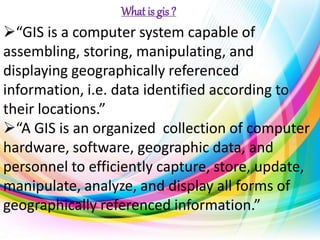
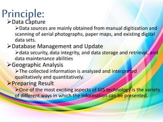
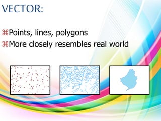
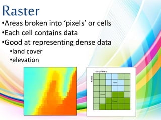
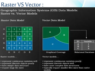
Geographical Information System (GIS) is a computer system for capturing, storing, analyzing, and displaying spatially-referenced data. GIS allows users to visualize relationships and patterns in data through maps, globes, reports, and charts. The key components of GIS are data capture, database management, geographic analysis, and result preparation. GIS data comes in vector and raster formats, with vector being better for representing real-world features precisely and raster being better for dense data like elevation or land cover. GIS provides accurate data, better analysis and predictions, and helps answer questions by visualizing spatial relationships. However, GIS software can be expensive and difficult to integrate with traditional maps.
This is most benificial for the First year Engineering students.This presentation consists of videos and many applications of GIS. The processes and the other parts of GIS is also nicely explained.
One of most important topics in ArcGIS and GIS, is coordinate system, the slides will cover this topic in order to understand the difference between various coordinate systems.
Gis Geographical Information System FundamentalsUroosa Samman
Gis, Geographical Information System Fundamentals. This presentation includes a complete detail of GIS and GIS Softwares. It will help students of GIS and Environmental Science.
The basic intention of this presentation is to help the beginners in GIS to understand what GIS is? It is a simple presentation about GIS, i mean an introductory one. Hope anyone finds it useful.
This presentation is about the raster and vector data in GIS which is important and costly as well, through the presentation we will learn about both type of data.
Geosys GIS training programs aims to give a strong theoretical foundation and excellent hands-on skills to prepare participants explore careers in and meet the challenges of the GIS world
GEOSYS Provides best classroom,Online,Corparate GIS(Geographic Information System) Trainings With 100% Live Projects,Job Placements,15+ Certifed Faculty,24*7 Lab Access in Hyderabad,Ameerpet @ 9581817878
http://geosys.co.in/home.html
I had to give presentation on GIS as a part of my CEC marks so here I have included all the points which are there in my curriculum and its all about Geographical Information System - GIS.
Conception et Développement d'un Network Management System ATM NortelTidiane Sylla
Ce projet consistait à développer une application web sous ASP .Net pour gérer et superviser des commutateurs ATM Nortel de Tunisie Télécom en 2012. De ce fait ce projet comporte une partie création lien Frame Relay, Circuit aal1ces, etc, SNMP et backup automatique.
Welcome to our ultimate guide to Geographical Information System (GIS). Discover how GIS revolutionizes data analysis, mapping.
Explore the comprehensive guide to Geographical Information System (GIS). Learn about GIS benefits, applications, and implementation. Click here to uncover the potential.
A Geographical Information System (GIS) is a computer-based tool used to capture, store, manipulate, analyse, and present spatial or geographic data. It combines various types of data such as maps, satellite imagery, aerial photographs, and tabular data to create layers of information that can be visualized and analysed in relation to their geographic location.
GIS technology allows users to explore, interpret, and understand patterns and relationships within geographic data. It provides a framework for organizing and managing data, enabling users to query and retrieve specific information based on spatial and non-spatial attributes. GIS can be used in various fields, including urban planning, natural resource management, environmental assessment, transportation, agriculture, and emergency management
The Art Pastor's Guide to Sabbath | Steve ThomasonSteve Thomason
What is the purpose of the Sabbath Law in the Torah. It is interesting to compare how the context of the law shifts from Exodus to Deuteronomy. Who gets to rest, and why?
The Indian economy is classified into different sectors to simplify the analysis and understanding of economic activities. For Class 10, it's essential to grasp the sectors of the Indian economy, understand their characteristics, and recognize their importance. This guide will provide detailed notes on the Sectors of the Indian Economy Class 10, using specific long-tail keywords to enhance comprehension.
For more information, visit-www.vavaclasses.com
Ethnobotany and Ethnopharmacology:
Ethnobotany in herbal drug evaluation,
Impact of Ethnobotany in traditional medicine,
New development in herbals,
Bio-prospecting tools for drug discovery,
Role of Ethnopharmacology in drug evaluation,
Reverse Pharmacology.
2024.06.01 Introducing a competency framework for languag learning materials ...Sandy Millin
http://sandymillin.wordpress.com/iateflwebinar2024
Published classroom materials form the basis of syllabuses, drive teacher professional development, and have a potentially huge influence on learners, teachers and education systems. All teachers also create their own materials, whether a few sentences on a blackboard, a highly-structured fully-realised online course, or anything in between. Despite this, the knowledge and skills needed to create effective language learning materials are rarely part of teacher training, and are mostly learnt by trial and error.
Knowledge and skills frameworks, generally called competency frameworks, for ELT teachers, trainers and managers have existed for a few years now. However, until I created one for my MA dissertation, there wasn’t one drawing together what we need to know and do to be able to effectively produce language learning materials.
This webinar will introduce you to my framework, highlighting the key competencies I identified from my research. It will also show how anybody involved in language teaching (any language, not just English!), teacher training, managing schools or developing language learning materials can benefit from using the framework.
Read| The latest issue of The Challenger is here! We are thrilled to announce that our school paper has qualified for the NATIONAL SCHOOLS PRESS CONFERENCE (NSPC) 2024. Thank you for your unwavering support and trust. Dive into the stories that made us stand out!
We all have good and bad thoughts from time to time and situation to situation. We are bombarded daily with spiraling thoughts(both negative and positive) creating all-consuming feel , making us difficult to manage with associated suffering. Good thoughts are like our Mob Signal (Positive thought) amidst noise(negative thought) in the atmosphere. Negative thoughts like noise outweigh positive thoughts. These thoughts often create unwanted confusion, trouble, stress and frustration in our mind as well as chaos in our physical world. Negative thoughts are also known as “distorted thinking”.
How to Make a Field invisible in Odoo 17Celine George
It is possible to hide or invisible some fields in odoo. Commonly using “invisible” attribute in the field definition to invisible the fields. This slide will show how to make a field invisible in odoo 17.
Operation “Blue Star” is the only event in the history of Independent India where the state went into war with its own people. Even after about 40 years it is not clear if it was culmination of states anger over people of the region, a political game of power or start of dictatorial chapter in the democratic setup.
The people of Punjab felt alienated from main stream due to denial of their just demands during a long democratic struggle since independence. As it happen all over the word, it led to militant struggle with great loss of lives of military, police and civilian personnel. Killing of Indira Gandhi and massacre of innocent Sikhs in Delhi and other India cities was also associated with this movement.
2. Objective
What Is GIS?
Principle Of GIS.
Function Of GIS.
Components Of GIS.
Type Of GIS.
Advantages Of GIS.
Applications Of GIS.
3. “GIS is a computer system capable of
assembling, storing, manipulating, and
displaying geographically referenced
information, i.e. data identified according to
their locations.”
“A GIS is an organized collection of computer
hardware, software, geographic data, and
personnel to efficiently capture, store, update,
manipulate, analyze, and display all forms of
geographically referenced information.”
What is gis ?
4. Principle:Data Capture
Data sources are mainly obtained from manual digitization and
scanning of aerial photographs, paper maps, and existing digital
data sets.
Database Management and Update
data security, data integrity, and data storage and retrieval, and
data maintenance abilities
Geographic Analysis
The collected information is analyzed and interpreted
qualitatively and quantitatively.
Preparing Result
One of the most exciting aspects of GIS technology is the variety
of different ways in which the information can be presented.
5. Functions:Data Capture
The input of data into a GIS can be achieved through many
different methods of gathering. For example, aerial photography,
scanning, digitizing, GPS or global positioning system is just a few of
the ways a GIS user could obtain data.
Data Storage
Some data is stored such as a map in a drawer, while others, such
as digital data, can be as a hardcopy, stored on CD or on your hard
drive.
Data Manipulation
The digital geographical data can be edited, this allows for many
attribute to be added, edited, or deleted to the specification of the
project.
Query And Analysis
GIS was used widely in decision making process for the new
commission districts. We use population data to help establish an
equal representation of population to area for each district.
Visualization
This represents the ability to display your data, your maps, and
information.
13. Disadvantages (Raster)
•Large Data Volume.
•Inefficient use of computer storage.
•Difficult network analysis.
•Less accurate or attractive maps.
•Loss of information when using large
cells.
14. Advantages of GIS
•GIS allows us to view, understand, and visualize
data in many ways that reveal relationships,
patterns, and trends in the form of maps, globes,
reports, and charts.
•A GIS helps you answer questions and solve
problems by looking at your data in a way that is
quickly understood and easily shared.
•GIS give the accurate Data.
•Better Predictions and Analysis.
15. Disadvantages of GIS
•Excessive damage in case of internal fault.
Long outage periods as
Repair of damaged part at site may be
difficult.
•Expensive software.
•Integration with traditional map is
difficult.
16. Conclusion
•GIS has provided to be a really useful
application, its evolution with the changing
times has been totally progressive.
• With the changes in the latest hardware’s
and the software’s GIS will be used for the
best of its purposes.