WordPress Websites for Engineers: Elevate Your Brand
GIS Lecture Note.ppt
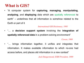
1. What is GIS?
• “A computer system for capturing, managing, manipulating,
analyzing, and displaying data which are spatially referenced to
earth” – underlines that all information is somehow related to the
Earth or part of it
International GIS Dictionary, 1995
• “… a decision support system involving the integration of
spatially referenced data in a problem-solving environment”
Cowen, 1988
• “… brings information together, it unifies and integrates that
information. It makes available information to which no-one had
access before, and places old information in a new context”
Jack Dangermond, ESRI President, 1989
2. GIS…
• GIS combines three aspects: Geography + Information + System.
• Geography is related to features and processes that occur on the
surface of the earth.
• Information is the heart of GIS, whereby vast amounts of data are
stored and analyzed.
• System is what connects everything – the hardware, software,
data, and human operator – all working together to ask questions,
discover answers, and display them in ways that promote
understanding of what it means to live on earth.
3. GIS…
• Imagine having stack of a large
number of different maps of the
same area neatly in a pile, one on
top of the other, and asking
yourself questions and find
answers using all the information
contained on those maps. That,
exactly, is what a GIS does. You
can ask questions, sort, and even
create new maps .
4. Evolution of GIS
• Geographical (geographic) Information System has existed since the
1960s, although the techniques used by GIS today predate this
period.
Example, John Snow in 18th Century(Epidemiology)- the case of
mapping to understand the cause and patterns of the spatial
distribution of cholera outbreak in the then northern parts of London,
England.
6. Evolution…
• 1950 – Tyrwhitt invents the overlay technique (using slides to make
an “earth characteristics” map).
• 1959 – Waldo Tobler: MIMO model (Map In Map Out) with three modules:
map input, data manipulation and map output.
• 1960 – Logical and numerical modeling (computing) toolbox development
– the need for spatial information increases in various sectors -> thematic
maps emerge.
• 1960 – programming languages (FORTRAN).
• 1960 – First digitizing tablet
• 1960 – Aerial photographs, satellite images
• 1974 – International Geographical Union launches the term “GIS”
• 1975 – First GIS publication: program Odyssey (Harvard University)Vector
data structure (arc node) (topology)
• 1982 – PC introduction
• 1990 – Development of GIS as a complete technology
7. Evolution...
• The Canadian Department of Forestry and Rural Development
recognized the need to monitor and manage natural resources i.e.
Inventories of resources;
Plan their sustainable use and;
Comply with legislation
• The fact that manual mapping and analysis remained laborious,
expensive and time consuming, it has resulted in the birth of
Canadian Geographic Information Systems (CGIS) in mid 1960s –
the first of its kind.
• This eventually led to the conceptual and technological development
of GIS.
8. Evolution…
• In general, three important innovations favored the development of
GIS:
Development of computer technology
Theories of spatial process and quantitative geography
Increasing environmental awareness
9. Evolution…
In recent years (2000s), the use of GIS has grown dramatically which is
partly attributed to the following factors:
– The decreasing cost of computers, GIS software, and pre-captured data;
– Increasingly user-friendly software;
– The realization of the potential benefits of GIS;
– The increasing availability of spatial data in digital format;
– The appearance of GIS education and training programs in universities,
colleges, and schools, providing a GIS workforce;
– The development of complementary technologies, such as Remote Sensing
(RS) and Global Positioning Systems (GPS); and
– The growing need for conducting spatial decision-making in a more scientific
and accountable fashion.
10. Capabilities of GIS (What does GIS Do?)
• GIS provides wide ranges of functions and tools that can be
applied in many disciplines. The following is a list of spatial
questions GIS solves:
Location..........What is at…? e.g. what species of bird would I find in the
surrounds of Lake Hawassa? This refers to what exists at a particular
location.
Condition…….Where is it…? OR where does something occur? Using
spatial analysis, this question seeks to find a location where certain
conditions are satisfied (e.g., an unforested section of land, at least 2,000
m2 in size, within 100 meters off road, and with soils suitable for
supporting buildings).
11. Capabilities of GIS…
Trend……..What has changed since…? This question might involve a
combination of the first two and seeks to find the differences within an area
over time. e.g., how has land-use changed over time?
Routing…….which is the shortest way to a certain location? e.g. which is the
fastest route to an emergency?
Pattern…….. What spatial pattern exist…? You might ask this question to
determine whether cancer is a major cause of death among residents near a
nuclear power station.
Modeling/scenarios…….What if…? “What if…” questions are posed to
determine what happens, for example, if a new road is added to a network. OR
which areas would be affected by sea level rise or flooding?
12. Capabilities of GIS…
Further examples for modeling
Model the effect of logging a forest on soil erosion – from pre – logging to
two years post – logging.
Predict the effect of changing climatic conditions on the distribution of
malaria for the year 2050.
Model the spread of Hawassa urban sprawl (based on population and
housing data from the last ten years) and predict where the edge of the
urban region will be in the year 2030.
13. Capabilities of GIS…
• Many of these questions may be answered using traditional
methods, which may take many months, a great deal of patience, and
a large amount of money. These spatial questions, however, can be
handled easily and efficiently with GIS technology.
14. Areas of GIS Application
Jack Dangermond, CEO of ESRI, the leading GIS development company in the world, once
announced: “The application of GIS is only limited by the imagination of those who use it”
• Economic Development
• Agriculture (e.g. precision agriculture)
• Telecommunications (e.g. mobile phone network installation)
• Transportation and Service Routing
• Health (Epidemiology)
• Taxation
• Law Enforcement
• Resource Management
• Environmental Monitoring
• Forest Management and Planning
• Etc…
16. GIS Application…
Specialist
information system
(SIS):
- telematics
- traffic guidance
- corporate IS
- military IS
Spatial/Planning IS (PIS):
- Geogr. Applic.
- Planning IS
- Statistical IS
- Demography
Network information systems
(NIS):
- Utility IS (Gas, power, water etc.)
- Facility management
Environmental information systems
(EIS):
- Environ‘l Monitoring
- Habitat/species analysis
- Forestry and agriculture
LIS
SIS
NIS
EIS
PIS
10%
40 %
20 %
15%
15%
Land information systems
(LIS):
- Surveying/Cartography
- Cadaster
- Topographic IS
- Spatial reference frame
17. GIS Application…
• Land information systems (LIS)
Land information systems deal with the systematic capture and visualization
of all data that is related to a single piece of land.
it shows all characteristic data of a region to enhance planning and
development.
Most of the developed countries are now setting up automated land registers
combining the map and the book information they have on ownership and
real-estate.
Such systems were originally created in surveying and mapping disciplines and
are applied in surveying, real estate management and local and state
governmental mapping.
Very often they define the base maps (cadastral and topographic maps) for
all other users.
18. GIS Application…
• Network information systems (NIS)
Network information systems are instruments to capture, manage, analyze
and present working materials related to a network topology in a uniform
reference system.
They are applied in utility companies’ management of their facilities for
electricity, gas, clear and waste water, etc.
Municipalities manage their water supply and waste water networks with NIS,
they create traffic plans and monitor the noise emissions in the city with the
help of GIS.
• Regional, planning or statistical information systems (RIS)
Regional, planning or statistical information systems (RIS) are instruments for
decision support is spatial observations and tools for planning and
development.
They contain huge amount of data collected about population, economy and
urban development, infrastructure, land use and resources for regional
developments based on a common reference system.
Thematic cartography is the major output product of such systems.
19. GIS Application…
In municipalities, RIS are used to create housing and zoning plans, to draw
landscape plans, to plan the economic development of community and to
advertise for further establishing of enterprises.
GIS in the form of RIS is used for administrative work, for instance for school
registration, for elections etc.
• Environmental information systems (EIS)
These are advanced GIS for capture, storage, processing, and presentation of
environmental data, e.g. on hazards and pollutions, in space, time and
context.
These data are the basis for describing the status of the environment to
decide on protective measures.
The scale is usually rather small, and often raster data are dominating.
Environmental information systems are setup for the environmental media
soil, water and air.
They are used for nature and landscape protection planning and urban
climate monitoring.
20. GIS Application…
• Specialist information systems (SIS)
Beside the four application facets, there are nowadays many more branches
using GIS.
Specialist information systems (SIS) or branch-specific information systems is
an open special class of geo-information systems where we collect all special
applications that are not covered by the other classes.
Compared to LIS, NIS, EIS, and RIS, they have no generic characteristics.
Examples are car navigation systems, telecommunication systems, hotel and
tourism information systems, geo-marketing, military applications and many
others.
N.B: In principle, one can state that GIS is used wherever spatial data occur and
spatial analysis is needed.
21. GIS-Feasibilities and Impossibilities (N. Bartelme, 1995)
• What is a GIS able to do?
– Illustrate facts quickly and graphically
– Visualise comparisons between different options (highlight
variations)
– Support arguments (decisions)
– Support interdisciplinary work
• What is a GIS not able to do ?
– Define the problems/tasks for the user
– Ensure suitability of the chosen data and process model
– Guarantee that the results make sense
– Prevent the user from choosing a theoretically correct but too
expensive/complicated option
24. Components…
Can be GENERALIZED into:
1. Conceptual Components
Spatially referenced data (e.g. point, lines, and polygons, topological
relations)
These refer to anything that can be attributed to a location.
These are digital data that fuel the software and are usually stored
separately from the software. E.g. Satellite images, aerial
photographs, topographic maps, survey data, demographic data
etc.
Attributes (descriptive data of spatial features)
Behavior (rules and characteristics that determine which operations OR
procedures can be performed on objects)
Temporal dimension (date of origin of the information)
25. 2. Physical Components
Hardware
• This refers to the actual machinery used by the software. It ranges
from personal computers (PCs’), to plotters, digitizers, GPS etc.
26. Physical Components…
Software
• GIS software contain instructions to the computer that will be
interpreted into action. One example instruction may be ‘Start up the
software package’.
• There are many GIS software packages which vary in cost,
performance, computing platform, and interfaces. They could
also be either commercial or non-commercial (Free and Open
Source).
28. Physical Components…
Organizational structure (trained personnel)
• This includes both GIS experts and users. Trained personnel are
essential elements for successful implementation of GIS.
• This is part of the system that drives all decisions and actions.
• Implementation of GIS within organization often fails due to
lack of staff training or failure to employ trained staff.
• GIS posts include among others, GIS Project Manager, GIS Analyst,
Digitizer, Programmer etc.
29. 3. Functional Components
• The functional elements of GIS relate to its basic duties such as:
• data input,
• data storage,
• data management,
• data retrieval,
• data manipulation,
• data analysis,
• data modelling,
• data output and
• data display.
30. Functional Components…
• 1,Data Input: Bringing data into the GIS environment
• 2,Data Management: Controlling access to data and ensuring data
integrity and storage efficiency
• Data Manipulation: Allowing alteration of primary data
• Data Storage: Maintaining data in GIS format
• Data Output: Moving data (or analysis results) out of the GIS
• Data Retrieval: Calling data from a stored format into use
• Data Display: Visualising primary or derived data
31. 4. Knowledge & Methodology
GIS provides many tools, functions, and analytical approaches
to explore spatial issues. But remember that, no amount of:
Powerful hardware;
Sophisticated software;
Spatial functions;
Expensive data and
Trained professional can compensate for poor-
science i.e., Appropriate underlying methodology is
essential.
32. Types of GIS data
GIS integrates data types (spatial and non-spatial; data connectivity
OR topology) to create an ideal analysis and modelling environment for
geographical data.
Spatial data (Where is feature?) – its location/geometry
Non- spatial (attribute) data (What is this feature?)
Topology (What surrounds this feature?).This is constructed in
orders to describe connectivity between spatial features.
33. Spatial Data (Where is it?)
• Spatial data refers to any data that is found distributed on the
surface of the earth.
• Gives information on the location and shape of features
• They could be either natural or man-made
• Spatial data can be represented in several ways such as analogue
map, digital map, aerial photograph, satellite image, survey
document etc.
34. Spatial Data …
Spatial features on the face of the earth can be represented as:
Point Data - layers described by x,y coordinates (lat,long; east,
north).
Line/Polyline Data - layers that are described connected by x,y
points (nodes, events) and lines (arcs) between points (line
segments and polylines).
Polygons (areas) – described by enclosed lines (e.g. District).
Polygons, lines and points are sometimes called geographical
primitives as they represent the smallest units of spatial
information in a GIS layer of data.
36. Spatial…
• The user’s choice of the correct geographical primitive to represent
data will depend on scale, or the desired level of generalization in
the data.
• For example, a city may be represented by a dot on a small-scale
map (say 1: 1, 000,000), whereas it may be represented by a
polygon on a large scale map (say 1: 1000).
37. Non-spatial (Attribute) data (What is it?)
• An ATTRIBUTE is the information that describes map features
• In GIS, an entity can have multiple attributes
• Attribute data may be text strings (words) or numbers.
• Text string, or word attributes are commonly nominal data and are
usually represented by names, such as ‘owner’: “Abebe, Selamawit”.
38. Non-spatial data…
• Nominal data simply indicates what to call the object.
• Numerical attributes may be real or integer numbers,
• Boolean (0, 1), or ordinal, ranked data, such as low, moderate,
and high slope.
• Some examples:
Population number: 2,000,000
Tree species : tid
Asthma likelihood :0.9
39. Topology: What is its environment?
• Topology embodies spatial data relationships.
• It understands the relationships among neighbouring spatial data.
• This knowledge is important in spatial modelling and analysis.
• Example GIS queries that require topological information are:
Can I access Hawassa University from the main road?
Do young families tend to live next door to other young
families?
Is zigba forest borders the tid forest?
40. Map Features
• Area Features:
Features delineated by closed boundaries. Districts, land parcels,
and zones are examples of area features.
• Linear Features:
Sets of connected points that represent a feature that either has no
width or that has width but is shown by a single line at the scale of the
map being used. River, railroad tracks, utility lines, and roads are
examples of linear features.
41. Map Features (cont)…
• Point Features:
Data that either represents the location of a feature that has no
dimensions or a feature that has width and length but whose
perimeter cannot be mapped at the defined map scale.
E.g. Elevation control points, stream gauging stations, oil wells, and
small buildings.
43. GIS Data Models
In GIS, 2D map features (real world features) can be represented
in two different ways:
• Vector
• Raster (Grid)
44. Graphic Features
Digital representation of physical or man made elements takes
two forms:
• Vectors
Points or Nodes
Lines or Arcs
Polygons
• Raster Cells or Pixels
Images
46. GIS Data…
1. Vector Data Model
In vector data model, a real world feature is divided into
clearly defined objects and each object has geometry of
POINTS, LINES, and POLYGONS (areas).
Vector Raster
48. Vector…
Point Features (house, address)
• × ⁺
Line Features (river, boundary, road)
Polygon Features (parcel, field, districts)
49. Vector…
In vector data model:
• Point features are stored by single x, y coordinates,
• Lines by series of (connected) x, y coordinates while
• Polygon features are represented creating enclosed area.
• In all cases, however, the related attribute data, which are held
in separate files, are linked to each feature.
50. Vector…
• Is discrete data (data with definite boundary). E.g.
boundaries, road networks, water bodies etc.
• X, Y coordinates can be used to define points, lines, and
polygons with high level accuracy (i.e. exact location)
• Is relatively compact (storage volume)
• Has complex data structure
• Requires computer- intensive methods of analysis
• The volume of data depends on density of vertices
• Sources of data are mostly social and environmental aspects
• It is applicable to social, economic and administrative
purposes
• Has fixed resolution
51. Advantages of Vector Data Structures
Good representation of phenomenon ology
Compact
Topology can be completely described
Accurate graphics
Retrieval, updating and generalization of graphics and
attributes possible
light data easily manageable
Fast processing
52. Disadvantages of Vector Data Structures
Complex Data Structures
Combination of several vector polygon maps through overlay
creates difficulties
Simulation is difficult because each unit has a different
topological form
Display and plotting can be expensive, particularly for high
quality color
The technology is expensive, particularly for the more
sophisticated software and hardware
Spatial analysis and filtering within polygons are impossible
53. Advantages of Raster Data Structures
Simple data structures
Overlay and combination of maps and remote sensed
images easy
Some spatial analysis methods simple to perform
Simulation easy, because cells have the same size
and shape
Technology is cheap
54. Disadvantages of Raster Data Structures
The use of large cells to reduce data volumes means
that phenomenonologically recognizable structures
can be lost and there can be a serious loss of
information
Crude raster maps are considerably less beautiful than
line maps
Network linkages are difficult to establish
Projection transformations are time consuming
unless special algorithms or hardware is used.
55. 2. Raster (Grid) Data Model
• It is a representation of geographic data where real world is divided into
an array of cells that are usually square, but sometimes rectangular.
• The cells are sometimes called pixels (short for picture element), which is
the preferred name in the area of visualization.
• One of the commonest forms of raster data comes from remote sensing
satellites.
• Other similar data can be obtained from sensors mounted on aircraft
(aerial photographs)
56. Raster…
• Best represents continuous data. E.g. rainfall, vegetation and
slope
• Grids or matrix of cells have blocky, or stepped appearances
and so has poorer spatial accuracy
• Involves large data sets and large storage
• Has simple data structure
• More easily analysed and modelled
• Volume of data depends on cell size
• Remote sensing is an important source of data
• Can mostly be applied to resource and environmental
management issues
• Has variable resolution
57. Data accuracy and Quality
• Accuracy-the degree to which information on a map
or in a digital database matches true or accepted
values. Consider horizontal and vertical accuracy
with respect to geographic position, as well as
attribute, conceptual, and logical Accuracy.
58. Data quality
• Data quality-refers to the relative accuracy and
precision of a particular GIS dataset.
59. Representing 3D Surfaces in GIS
1. Digital Elevation Model (DEM) OR Digital Terrain Model (DTM)
This is a grid or raster representation of 3D surfaces and each cell
has an attribute of elevation.
2. Triangulated Irregular Network (TIN)
This is a vector representation of 3D surface whereby triangles are
tilted to indicate slope/elevation
60. Representing 3D…
3D surfaces (DEM or TIN) can be applied to assess, for
example, impact of sea level rise and others like:
slope (e.g. suitability for development)
aspects (direction of slope)
drainage networks
viewshed / line of sight (this is a very important aspect in
selecting ideal place to install mobile phone receivers).
61. GIS Data Input
• It is the process which converts the data from an existing form into
one that can be used by a GIS in a digital format.
• Gathering and converting data into digital formats
• Data input is the initial stage in any GIS project
• It is a complex , expensive and time consuming process that
requires much consideration.
• The data may be captured in either a vector format or in a raster
format.
62. Data Input …
• The GIS users need to know which software and hardware they are
going to be able to access throughout the life of the project, the most
appropriate format and structure of the data, and the requirements
of the project.
• A complicating factor is that GIS has two types of data and these
forms of data may need to be entered separately.
• These data are spatial and non-spatial (attribute).
64. Data Input Methods
There are various data input methods in GIS . The most common
ones are:
• Manual Digitizing (vector)
• Scanning (raster)
• Remote Sensing (raster)
• GPS (vector: point, line, area)
• Surveying
• Existing Digital Data (vector and/or raster)
• Etc.
65. Data Input Methods…
1. Semi - Automated Digitizing
It is a secondary data input method from existing sources
like topographic maps.
It is used to capture vector data
It is a process whereby the user traces line work on a map
using a puck, which looks very much like a computer
mouse.
The tracing takes place on top of a digitizing board that has
a mesh of sensory wires just beneath the surface.
66. Data Input Methods…
When the digitizing puck button is depressed, the wire mesh
registers where the puck is located and stores this location in
digital format.
Thus paper maps are digitally ‘traced’.
This input method is used primarily for spatial data.
Special requirements include :digitizing board/tablet, puck
67. Data Input Methods…
2. Scanning
It is an automatic data input method.
Secondary data input method.
Scanning results in a raster-structured geodataset .
Heads-up (on screen) digitising of scanned documents
Special Requirement: Scanner, vector zing software
69. Data Input Methods…
3. Keyboard Entry
It a manual attribute data entry method.
The data sources could be primary or secondary.
Special Requirements: none (Keyboard).
70. Data Input Methods…
4. Importing Existing Digital Data (vector and/or
raster)
It is an automatic data input method.
Special Requirements: software able to interpret importing
data format, knowledge of data in its native (original form).
71. Qualitative data
A data is qualitative when its value is a nominal one with
qualitative differences: components do not allow establishing
range relations between them
Qualitative data have to be shown such a manner that do not
suggest rank either quantity
Two possibilities: use geometric symbols or differential colour
in order to differentiate the different elements of the map
72. Qualitative data
• High quality data output devices and products are
often towards the top of the budget list of priorities
73. Quantitative data
Quantitative data with absolute values means
concrete quantity; the sum of the different values can
be calculated and has a real sense
The ratio values are calculated and expressed a series
of ratios or proportional values, such as percentage,
per km, per inhabitant.
74. Data Output
• Regardless of how the data is to be used or manipulated in GIS,
there will be a call for data output at some stage.
• It is this output product which will inspire a client, not the many hours
devoted to data entry.
• Data output encompasses displaying results and producing an end
product.
• High quality data output devices and products are often towards the
top of the budget list of priorities.
• This may be a display on the monitor, a digital file, a map, a graph, a
statistical table, a number, or a report.
75. Data Output…
• As with data input, there are many methods and mechanisms for
producing an output .
1. Drawing on a screen:
This is the cheapest and most easily updated output product.
In fact, it is common now to take data and software on a
computer to an agency or an employer and show the result to
the client on the screen as primary output product.
The client can request for alterations, which maybe possible to
make on the spot, before the map even touches paper as hard-
copy output.
76. Data output…
2. Printing or plotting onto paper:
The hard-copy map is still a product that makes and expense of
GIS viable to many.
A printed map, graph, table, or list in a hard-copy product that
may represent much GIS modeling and analysis, or simply data
entry.
Knowledge of cartography is desirable for producing high quality
displays.
77. Data output…
3. Exporting data into a file:
This involves taking data, still in its digital format, and
separating it from the GIS software.
This is often done to transfer data to another computer
software package, onto another computing system, or simply
to store (backup) GIS work.
The file may be put onto a computer tape, a disk,
electronically mailed, or stored on the computer hard drive.
It is the norm in many agencies and departments to use GIS
for analysis, then export the resulting data to another
software package designed expressly for creating graphs,
maps, or reports.
78. Data Output Methods
As with data input, there are many methods and mechanisms for producing
data output . The most common are listed below:
1. Drawing on the screen:
This is the cheapest and most easily updated output product. In fact, it
is common now to take data and software on a computer to an agency
or an employer and show the result to the client on the screen as
primary output product.
The client can request alterations, which maybe possible to make on
the spot, before the map even touches paper as hard-copy output.
79. Data Output…
2. Printing or plotting onto paper:
The hard-copy map is still a product that makes and expense of
GIS viable to many.
A printed map, graph, table, or list in a hard-copy product that
may represent much GIS modeling and analysis, or simply data
entry.
Knowledge of cartography is desirable for producing high
quality displays.
80. Data Output…
3. Exporting data into a file:
This involves taking data, still in its digital format, and separating it from the
GIS software.
This is often done to transfer data to another computer software package,
onto another computing system, or simply to store (backup) GIS work.
The file may be put onto a computer tape, a disk, electronically mailed, or
stored on the computer hard drive.
It is the norm in many agencies and departments to use GIS for analysis, then
export the resulting data to another software package designed expressly for
creating graphs, maps, or reports.
81. Overview of Arc GIS
• Arc GIS Desktop can be accessed using three software products:
▫ ArcView
▫ ArcEditor
▫ ArcInfo
• ArcView Provides comprehensive mapping and analysis tools along with simple
editing and geoprocessing tools.
• ArcEditor includes all the functionalities of ArcView plus advanced editing
capabilities for coverages and geodatabases.
• ArcInfo extends the functionality of both to include advanced geoprocessing.
82. ArcGIS Desktop
• ArcGIS Desktop includes three integrated applications:
– ArcMap
– ArcCatalog
– ArcToolbox
• Using these three applications, one can perform any GIS task, simple to
advanced including mapping, data management, geographic analysis, data
editing and geoprocessing.
83. I. ArcMap
• ArcMap is the premier application for Desktop GIS and mapping
84. ArcMap gives you the power to:
• Visualize: seeing patterns you couldn’t see before, revealing hidden
trends and distributions, and gaining new.
• Create: ArcMap provides you with all the tools you need to put your data
on a map and display it in an effective manner.
• Solve: working geographically lets you answer questions such as “ where
is…?,” “ how much…?, ” and “ what if…?”. Understanding these
relationships will help you make better decisions.
• Present: you can make great-looking publication quality maps and create
interactive displays that link reports, graphs, tables, drawings,
photographs and other elements to your data.
85. Viewing a Map
• ArcMap provides two different ways to view a map:
i. Data View
ii. Layout View
• Each view lets you look at and interact with the map in a specific way.
• To browse your geographic data on your map, choose data view
• Layout view should be used when you’re preparing your map to hang on
the wall, put in a report, or publish on a web.
88. ArcCatalog…
• ArcCatalog provides the following functions:
– Browse for maps and data: the catalog provides different views of the data’s contents.
– Explore the data:
– Table view: with table View, you can see the attributes of a geographic data source or
the contents of any other table in a database.
– View and create Metadata
– Search for maps and data
– Manage data sources: The catalog makes it easy to organize your data. You can create
shapefiles, geodatabases, tables and other file types.
90. ArcToolbox…
• There are two versions of ArcToolbox: the complete ArcToolbox that
comes with ‘ArcInfo’ and a lighter version that comes with ‘ArcView’ and
‘ArcEditor’.
• ArcToolbox for ArcInfo comes with a complete, comprehensive set of
tools (well over 150) for geoprocessing, data conversion, map sheet
management, overlay analysis, map projection, and much more
• ArcToolbox for ArcView and ArcEditor contains over 20 commonly used
tools for data conversion and management.
91. Data Types Supported in ArcGIS
• ArcGIS lets you work with an extensive array of data sources. The major
data types you can work with are as follows:
Shapefiles: These are native to ArcView. Shapefiles consists of at least three
files with .shp, .shx and .dbf extensions. Each shapefile contains one feature
class.
Coverages: These are data types native to ArcInfo. Geometry and attribute
information is stored in a number of files contained in a folder. Coverages may
contain one or more feature class and store topological relationships that
enables them to provide information on area, length, perimeter, adjacency,
and connectivity.
Geodatabases: Geodatabases are relational databases that contain geographic
information and are native to ArcGIS. They store feature geometry and
attribute in one database.
92. Data Types….
CAD drawings: You can bring Computer Aided Design (CAD) drawings directly
into ArcGIS from such sources as GPS receivers (when transferred directly)
and surveying data.
Images and Grids: Satellite images, aerial photographs, and other raster data
such as Grids can be brought into ArcGIS. ArcGIS ArcView can only display
these data types but doesn’t allow processing.
Editor's Notes
There are two conceptually different data models available for storing GIS-databases; the vector model and the raster model. Most advanced GIS software can handle both models and even convert data between the two.
The real world can be described using two conceptually models:
As discrete objects: possible to represent as points, lines or polygons.
As a continuous surface with no discrete or distinct borders like temperature and precipitation.
To map houses and roads in area, discrete objects are more suitable to use since these have defined spatial extent,
But to make a topographic map, a continuous surface should be used since topography has a continuous spatial variation.
Merits of Vector data model:
Exact: Good measurements (e.g. of length and area)
Sometimes fast: e.g. when tracing lines. Many operations are easy to perform on vector data models e.g. network analysis (tracing lines and measuring distances along networks)
Good for visualization: for the same reason at it is exact, the vector model yields neat good looking maps for all types of objects that are suitably represented by the model.
Compact in terms of data structure: vector data structures demand much less computer storage space than raster data structure.
The data structure do not allow empty cells. This in turn will cause raster databases to be large in respect of storage usage on the computer hard disk. However, more sophisticated software normally use different data compression techniques.