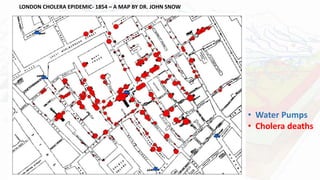
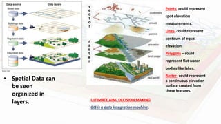
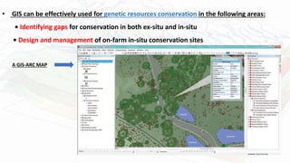
Geographic Information Systems
AKASH KUMAR SINGH
M.Sc. Botany Sem 2
Roll No. 2110014165021
What Is Geographic Information System?
• Geographic - Relates to places on the Earth’s surface
Where something is
AND
What is at a given location
• Information System-
oManipulate, summarize, query, edit, visualize
oWork with information stored in computer databases
Roger Tomlinson (Father of
GIS )
LONDON CHOLERA EPIDEMIC- 1854 – A MAP BY DR. JOHN SNOW
• Water Pumps
• Cholera deaths
GIS is a computer-based information system designed to
accept large volumes of spatial data derived from a variety of
sources and to efficiently store, retrieve, analyze, model, and
display (output) these data according to user-defined
specifications.
Data Computer Information GIS Knowledge
• Spatial Data can
be seen
organized in
layers.
Points- could represent
spot elevation
measurements.
Lines- could represent
contours of equal
elevation.
Polygons – could
represent flat water
bodies like lakes.
Raster- could represent
a continuous elevation
surface created from
these features.
ULTIMATE AIM- DECISION MAKING
GIS is a data integration machine.
Applications In
Plant Taxonomy
• Crop Expansion Strategies- GIS can play a crucial role by way of managing
large data sets, identifying suitable locations for multiplication and
evaluation of germplasm introduced from other countries.
• Compare:
• Climatic condition data
• Soil quality data
• pH data
• Temperature data
• Water requirement data
• Topographic data
• Mapping and Monitoring of Plant Species- Knowledge of the distribution of
species can form a critical component for managing ecosystems.
• GIS can be effectively used for genetic resources conservation in the following areas:
• Identifying gaps for conservation in both ex-situ and in-situ
• Design and management of on-farm in-situ conservation sites
A GIS-ARC MAP
THANK YOU!

GIS presentation.pptx

  • 1.
    Geographic Information Systems AKASHKUMAR SINGH M.Sc. Botany Sem 2 Roll No. 2110014165021
  • 2.
    What Is GeographicInformation System? • Geographic - Relates to places on the Earth’s surface Where something is AND What is at a given location • Information System- oManipulate, summarize, query, edit, visualize oWork with information stored in computer databases Roger Tomlinson (Father of GIS )
  • 3.
    LONDON CHOLERA EPIDEMIC-1854 – A MAP BY DR. JOHN SNOW • Water Pumps • Cholera deaths
  • 4.
    GIS is acomputer-based information system designed to accept large volumes of spatial data derived from a variety of sources and to efficiently store, retrieve, analyze, model, and display (output) these data according to user-defined specifications. Data Computer Information GIS Knowledge
  • 5.
    • Spatial Datacan be seen organized in layers. Points- could represent spot elevation measurements. Lines- could represent contours of equal elevation. Polygons – could represent flat water bodies like lakes. Raster- could represent a continuous elevation surface created from these features. ULTIMATE AIM- DECISION MAKING GIS is a data integration machine.
  • 6.
  • 7.
    • Crop ExpansionStrategies- GIS can play a crucial role by way of managing large data sets, identifying suitable locations for multiplication and evaluation of germplasm introduced from other countries. • Compare: • Climatic condition data • Soil quality data • pH data • Temperature data • Water requirement data • Topographic data
  • 8.
    • Mapping andMonitoring of Plant Species- Knowledge of the distribution of species can form a critical component for managing ecosystems.
  • 9.
    • GIS canbe effectively used for genetic resources conservation in the following areas: • Identifying gaps for conservation in both ex-situ and in-situ • Design and management of on-farm in-situ conservation sites A GIS-ARC MAP
  • 10.