Downloaded 522 times
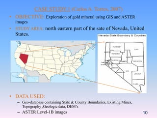


The document discusses using ASTER satellite imagery and GIS for mineral exploration. It provides details on two case studies: 1) identifying gold deposits in Nevada using ASTER data integrated into a geodatabase, and 2) mapping alteration zones in India using ASTER shortwave infrared bands. The case studies demonstrate how ASTER imagery can be processed and analyzed using GIS and techniques like principal component analysis to produce geological maps and identify target areas for further mineral exploration.