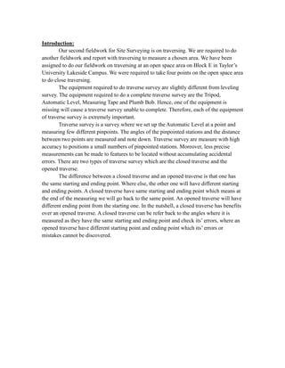
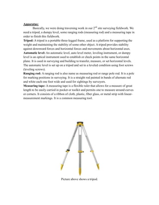
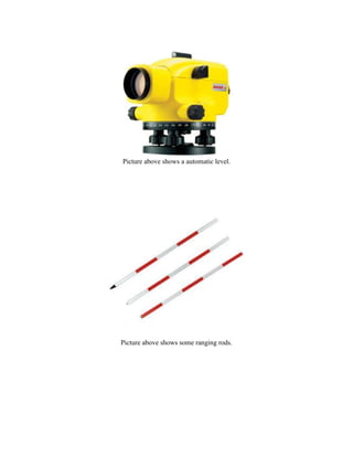
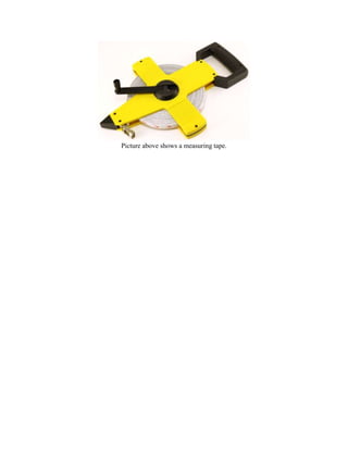
SlideShare a Scribd company logo
________________________
SITE SURVEYING (QSB 1813)
SEMESTER 2
FIELDWORK REPORT 2
NAME

STUDENT ID

LIEW CHEE HOW

0314758

FELIX LAU CIUN

0301789

WOO
TEO JUN TANG

0314667

YAP HUE ENG

0314857

YAP ZHI XIN

0314542

SUBMISSION DATE: 4 DECEMBER 2013
CONTENTS
NO. COTENTS

PAGE NO.

1

OBJECTIVE

1

2

INTRODUCTION

2

3

EQUIPMENT

3

4

RESULT

5

DISCUSSION

6

6

CONCLUSION

8
Objective:
The objectives of this field work are:
-

To have a better understanding of the procedure for traversing.
To have experiences to the actual working environment on the site including
uncertainty weather condition.
To have witness the usage of equipment and apparatus on site.
To have the ability to setting up the tripod and adjusting the staff bubble.
To understand how to find out the azimuth from a point to another.
To have skills in using the auto meter level for correct reading
To increase the team working skills among group members.
To have the ability in recording data for the field work
To understand the angle of adjustment of traversing.
To have skills in applying formulae in calculation.
Introduction:
Our second fieldwork for Site Surveying is on traversing. We are required to do
another fieldwork and report with traversing to measure a chosen area. We have been
assigned to do our fieldwork on traversing at an open space area on Block E in Taylor’s
University Lakeside Campus. We were required to take four points on the open space area
to do close traversing.
The equipment required to do traverse survey are slightly different from leveling
survey. The equipment required to do a complete traverse survey are the Tripod,
Automatic Level, Measuring Tape and Plumb Bob. Hence, one of the equipment is
missing will cause a traverse survey unable to complete. Therefore, each of the equipment
of traverse survey is extremely important.
Traverse survey is a survey where we set up the Automatic Level at a point and
measuring few different pinpoints. The angles of the pinpointed stations and the distance
between two points are measured and note down. Traverse survey are measure with high
accuracy to positions a small numbers of pinpointed stations. Moreover, less precise
measurements can be made to features to be located without accumulating accidental
errors. There are two types of traverse survey which are the closed traverse and the
opened traverse.
The difference between a closed traverse and an opened traverse is that one has
the same starting and ending point. Where else, the other one will have different starting
and ending points. A closed traverse have same starting and ending point which means at
the end of the measuring we will go back to the same point. An opened traverse will have
different ending point from the starting one. In the nutshell, a closed traverse has benefits
over an opened traverse. A closed traverse can be refer back to the angles where it is
measured as they have the same starting and ending point and check its’ errors, where an
opened traverse have different starting point and ending point which its’ errors or
mistakes cannot be discovered.
Apparatus:
Basically, we were doing traversing work in our 2nd site surveying fieldwork. We
need a tripod, a dumpy level, some ranging rods (measuring rod) and a measuring tape in
order to finish this fieldwork.
Tripod: A tripod is a portable three-legged frame, used as a platform for supporting the
weight and maintaining the stability of some other object. A tripod provides stability
against downward forces and horizontal forces and movements about horizontal axes.
Automatic level: An automatic level, auto level meter, leveling instrument, or dumpy
level is an optical instrument used to establish or check points in the same horizontal
plane. It is used in surveying and building to transfer, measure, or set horizontal levels.
The automatic level is set up on a tripod and set to a leveled condition using foot screws
(leveling screws).
Ranging rod: A ranging rod is also name as measuring rod or range pole rod. It is a pole
for marking positions in surveying. It is a straight rod painted in bands of alternate red
and white each one foot wide and used for sightings by surveyors.
Measuring tape: A measuring tape is a flexible ruler that allows for a measure of great
length to be easily carried in pocket or toolkit and permits one to measure around curves
or corners. It consists of a ribbon of cloth, plastic, fiber glass, or metal strip with linearmeasurement markings. It is a common measuring tool.

Picture above shows a tripod.
Picture above shows a automatic level.

Picture above shows some ranging rods.
Picture above shows a measuring tape.
Discussion:
Our group consists of five members. In this fieldwork, we are required to conduct
traversing around the campus. Here, the main activity we have to conduct is to set up the
measuring rod at different points and use the auto level machine to calculate the angle
between the measuring rods. The site which we conduct traversing is at the balcony at L.2.
In this fieldwork, we are going to set up a closed traverse. We were told that a closed
traverse will basically consist of four points which will make up a polygon. Closed
traverse involves the usage of interior angle to locate the points of the measuring rod.
We set up our tripod with the auto level meter on it. Having the air bubble inside the
boundary of the circle is to ensure the auto level meter is on a flat surface. Then one of
our group members holding the measuring rod is required to stand at the point we fixed.
The important thing here is that the person holding the measuring rod has to maintain the
rod at the fixed point and remember where the point is located as this affects the accuracy
of measurement. Our problem is that we only have two measuring rod for each group.
The first point is measured as 0˚ and till the second measuring rod is set up, the angle
between these two points is measured. In order to solve this problem, we use stones to
pinpoint the location of the measuring rod. Next, the length from the center of the tripod
to the point of the measuring rod is measured. We also measured the length between the
measuring rods. We are also encouraged to take a larger distance between the measuring
rods. In order to get the center below the auto level meter, the plumb bod is hung onto the
hook at the center of the tripod.
In this fieldwork, our group is effective and fast. We were fast enough to finish our
traversing before the sun gets too hot. We had set up four points as required and after
measuring all the lengths and angle between the measuring rods from the auto level meter,
our group get some confusion when we looked back to our data. Our group members
started to discuss about the data collected. Here, our lecturer, Sir Wong JeeKhai help us a
lot as he gave us a few questions to be thought through so that we knew how we could get
two of the internal angles at the end and found out where is the root of our problems. Our
problem is mainly about data recording. The angle measured is in between the measuring
rod taking the tripod as the center but the recording of data records the internal angle to
be the angles between the measuring rods. Throughout this process, we are required to
think and discuss among ourselves to solve this confusion and we learn how to discuss
and cooperate among each other so that we can find the answers to our question. At the
end, we were able to understand the steps to calculate the internal angles using both the
length and angles we had measured. The solution here is to have a clear idea on the
angles we have and use the trigonometry to find the length and angles of other parts.
After all these data collection and discussion, we started calculating all the internal
angles of our closed traverse. When we found out there is an error present, we had to
carry out the angle adjustment for closed traverse. This process requires the balancing of
internal angles, computation of latitudes and departure and also the balancing of latitudes
and departures. Latitude can be considered as the ∆Y and departure as the ∆X. The
calculation will include calculation using trigonometry sin and cos. As we were not given
the coordinate of one of the point, we could not compute the coordinates of the remaining
points.
Below are the formulae we used in calculation:
1. Sum of internal angle of polygon = (n – 2) x 180˚
2. Misclosure =
3. Latitude (∆Y) = Distance (H) cos α
4. Departures (∆X) = Distance (H) sin α
5. Error = ∑∆Y / ∑∆X
6. Correction = Error x
7. Adjusted ∆Y = ∆Y – Correction
8. Adjusted ∆X = ∆X – Correction

–
Conclusion:
Traversing is one of main task to identify the pin point on the map or in construction
drawing, so that we will stick to the boundary accurately. In this field work we did come
through some of the obstacle and have greater understanding on traversing. By carry out
this field work, we find that it is much harder compared with calculations we do in the
class. It is because there are so many mistakes we could pick up by not concentrating on
what we are doing or rushing it. Moreover, it allows us to hands-on on the equipment.
This is a great experience to explore and have a better knowing on the equipment.
Furthermore, our team have shown a good team work spirit. All of us get to their own
station and carry out their duty in no time. Besides that, we have adopted a systematic
way to carry out the task. We try to picture out the area that we are going to measure and
distribute job accordingly. In conclusion, this field work benefit us by stepping out of the
classroom which allow us to open our up our eyes and look into the practical part of it.

More Related Content

What's hot

Surveying by using Digital Theodolite
Surveying by using Digital TheodoliteSurveying by using Digital Theodolite
Surveying by using Digital Theodolite
Ehab AL-Timimi
 
2.horizontal curves
2.horizontal curves2.horizontal curves
2.horizontal curves
fenta dejene
 
Introduction to Surveying LEVELLING PROCEDURES
Introduction to Surveying LEVELLING PROCEDURESIntroduction to Surveying LEVELLING PROCEDURES
Introduction to Surveying LEVELLING PROCEDURES
Bahzad5
 
Site Surveying Traversing
Site Surveying TraversingSite Surveying Traversing
Site Surveying Traversing
ashleyyeap
 
Total station
Total stationTotal station
Total station
lbbinh
 
Lecture 04 angle corrections
Lecture 04 angle correctionsLecture 04 angle corrections
Lecture 04 angle corrections
Rehan Hanif
 

What's hot (20)

Surveying by using Digital Theodolite
Surveying by using Digital TheodoliteSurveying by using Digital Theodolite
Surveying by using Digital Theodolite
 
Fieldwork 2 (Traversing)
Fieldwork 2 (Traversing)Fieldwork 2 (Traversing)
Fieldwork 2 (Traversing)
 
2.horizontal curves
2.horizontal curves2.horizontal curves
2.horizontal curves
 
Profile and Cross-Section - Report
Profile and Cross-Section - ReportProfile and Cross-Section - Report
Profile and Cross-Section - Report
 
SITE SURVEYING LEVELING
SITE SURVEYING LEVELINGSITE SURVEYING LEVELING
SITE SURVEYING LEVELING
 
Tacheometry @surveyingreport
Tacheometry @surveyingreportTacheometry @surveyingreport
Tacheometry @surveyingreport
 
Levelling
LevellingLevelling
Levelling
 
Levelling report
Levelling reportLevelling report
Levelling report
 
Tacheometric survey
Tacheometric surveyTacheometric survey
Tacheometric survey
 
Introduction to Surveying LEVELLING PROCEDURES
Introduction to Surveying LEVELLING PROCEDURESIntroduction to Surveying LEVELLING PROCEDURES
Introduction to Surveying LEVELLING PROCEDURES
 
Assignment 2 - Traverse
Assignment 2 - TraverseAssignment 2 - Traverse
Assignment 2 - Traverse
 
Site Surveying Traversing
Site Surveying TraversingSite Surveying Traversing
Site Surveying Traversing
 
Ss report 1
Ss report 1Ss report 1
Ss report 1
 
Site Surveying Report - Traversing
Site Surveying Report - TraversingSite Surveying Report - Traversing
Site Surveying Report - Traversing
 
Balancing of traverse
Balancing of traverseBalancing of traverse
Balancing of traverse
 
Unit 4
Unit 4Unit 4
Unit 4
 
Total station
Total stationTotal station
Total station
 
Lecture 04 angle corrections
Lecture 04 angle correctionsLecture 04 angle corrections
Lecture 04 angle corrections
 
Two pegtest
Two pegtestTwo pegtest
Two pegtest
 
Introduction to surveying
Introduction to surveyingIntroduction to surveying
Introduction to surveying
 

Viewers also liked

Fieldwork 2
Fieldwork 2 Fieldwork 2
Fieldwork 2
JamesMoy7
 
Site report for Measurement 1
Site report for Measurement 1Site report for Measurement 1
Site report for Measurement 1
Yap Xin
 
Site survey Fieldwork 2 traversing
Site survey Fieldwork 2 traversingSite survey Fieldwork 2 traversing
Site survey Fieldwork 2 traversing
Sheng Zhe
 
Project 1- Levelling
Project 1- Levelling Project 1- Levelling
Project 1- Levelling
seenyee
 
Levelling final
Levelling finalLevelling final
Levelling final
seenyee
 
S2 3.1 tape and offset surveying
S2 3.1 tape and offset surveyingS2 3.1 tape and offset surveying
S2 3.1 tape and offset surveying
Est
 
Site survey Fieldwork1 (levelling)
Site survey Fieldwork1 (levelling)Site survey Fieldwork1 (levelling)
Site survey Fieldwork1 (levelling)
Sheng Zhe
 
Site surveying report1
Site surveying report1Site surveying report1
Site surveying report1
Est
 

Viewers also liked (20)

Site Surveying Report 1 (Levelling)
Site Surveying Report 1 (Levelling)Site Surveying Report 1 (Levelling)
Site Surveying Report 1 (Levelling)
 
Fieldwork 2
Fieldwork 2 Fieldwork 2
Fieldwork 2
 
Site report for Measurement 1
Site report for Measurement 1Site report for Measurement 1
Site report for Measurement 1
 
Ss report 1
Ss report 1Ss report 1
Ss report 1
 
Site Surveying report2 traversing
Site Surveying report2 traversingSite Surveying report2 traversing
Site Surveying report2 traversing
 
Site survey Fieldwork 2 traversing
Site survey Fieldwork 2 traversingSite survey Fieldwork 2 traversing
Site survey Fieldwork 2 traversing
 
Assignment 1
Assignment 1Assignment 1
Assignment 1
 
Fieldwork 1
Fieldwork 1Fieldwork 1
Fieldwork 1
 
Surveying l
Surveying lSurveying l
Surveying l
 
Bandar Sunway Lagoon
Bandar Sunway LagoonBandar Sunway Lagoon
Bandar Sunway Lagoon
 
Surveying
SurveyingSurveying
Surveying
 
Project 1- Levelling
Project 1- Levelling Project 1- Levelling
Project 1- Levelling
 
Levelling final
Levelling finalLevelling final
Levelling final
 
S2 3.1 tape and offset surveying
S2 3.1 tape and offset surveyingS2 3.1 tape and offset surveying
S2 3.1 tape and offset surveying
 
Site survey Fieldwork1 (levelling)
Site survey Fieldwork1 (levelling)Site survey Fieldwork1 (levelling)
Site survey Fieldwork1 (levelling)
 
Site surveying report1
Site surveying report1Site surveying report1
Site surveying report1
 
Theodolite report
Theodolite reportTheodolite report
Theodolite report
 
Introduction to Sunway Berhad
Introduction to Sunway BerhadIntroduction to Sunway Berhad
Introduction to Sunway Berhad
 
Leveling final-report
Leveling final-reportLeveling final-report
Leveling final-report
 
Sunway Group
Sunway Group Sunway Group
Sunway Group
 

Similar to Site Surveying Fieldwork 2

ABC Report - 123 (gathered with reference)
ABC Report - 123 (gathered with reference)ABC Report - 123 (gathered with reference)
ABC Report - 123 (gathered with reference)
Jing Chuang
 
GNSS Localizations for Construction
GNSS Localizations for ConstructionGNSS Localizations for Construction
GNSS Localizations for Construction
David Rowlett
 
Sem 2 Site surveying report 2
Sem 2 Site surveying report 2Sem 2 Site surveying report 2
Sem 2 Site surveying report 2
Est
 
ABSTRACT The objective of this experiment is to calculate the ar.docx
ABSTRACT The objective of this experiment is to calculate the ar.docxABSTRACT The objective of this experiment is to calculate the ar.docx
ABSTRACT The objective of this experiment is to calculate the ar.docx
ransayo
 
G6 m5-a-lesson 3-t
G6 m5-a-lesson 3-tG6 m5-a-lesson 3-t
G6 m5-a-lesson 3-t
mlabuski
 
Constant velocity presentation
Constant velocity presentationConstant velocity presentation
Constant velocity presentation
smithnj
 
Lecture_3_The Principles of Levelling_fec6a71b84edc28ee2998f7ced9ddf68.pdf
Lecture_3_The Principles of Levelling_fec6a71b84edc28ee2998f7ced9ddf68.pdfLecture_3_The Principles of Levelling_fec6a71b84edc28ee2998f7ced9ddf68.pdf
Lecture_3_The Principles of Levelling_fec6a71b84edc28ee2998f7ced9ddf68.pdf
AlwandBarzani
 

Similar to Site Surveying Fieldwork 2 (20)

2 nd report
2 nd report2 nd report
2 nd report
 
ABC Report - 123 (gathered with reference)
ABC Report - 123 (gathered with reference)ABC Report - 123 (gathered with reference)
ABC Report - 123 (gathered with reference)
 
Survey camp report main (2nd) Part
Survey camp report main (2nd) PartSurvey camp report main (2nd) Part
Survey camp report main (2nd) Part
 
Civil survey camp traning report file 2018 git jaipur (8741828148)
Civil survey camp traning report file 2018 git jaipur (8741828148)Civil survey camp traning report file 2018 git jaipur (8741828148)
Civil survey camp traning report file 2018 git jaipur (8741828148)
 
GNSS Localizations for Construction
GNSS Localizations for ConstructionGNSS Localizations for Construction
GNSS Localizations for Construction
 
Learners Module Quarter 3 and 4 Grade 7
Learners Module Quarter 3 and 4 Grade 7Learners Module Quarter 3 and 4 Grade 7
Learners Module Quarter 3 and 4 Grade 7
 
Site surveying assignment
Site surveying assignmentSite surveying assignment
Site surveying assignment
 
Sem 2 Site surveying report 2
Sem 2 Site surveying report 2Sem 2 Site surveying report 2
Sem 2 Site surveying report 2
 
ABSTRACT The objective of this experiment is to calculate the ar.docx
ABSTRACT The objective of this experiment is to calculate the ar.docxABSTRACT The objective of this experiment is to calculate the ar.docx
ABSTRACT The objective of this experiment is to calculate the ar.docx
 
Ss report 2
Ss report 2Ss report 2
Ss report 2
 
Traverse @surveyingreport
Traverse @surveyingreportTraverse @surveyingreport
Traverse @surveyingreport
 
1.4 Modeling And Analysis, The Mongolian Steppe Steps
1.4 Modeling And Analysis, The Mongolian Steppe Steps1.4 Modeling And Analysis, The Mongolian Steppe Steps
1.4 Modeling And Analysis, The Mongolian Steppe Steps
 
ROAD PROFILING, CROSS SECTION & SETTING OUT SEWER LINE
ROAD  PROFILING, CROSS SECTION & SETTING OUT SEWER LINEROAD  PROFILING, CROSS SECTION & SETTING OUT SEWER LINE
ROAD PROFILING, CROSS SECTION & SETTING OUT SEWER LINE
 
G6 m5-a-lesson 3-t
G6 m5-a-lesson 3-tG6 m5-a-lesson 3-t
G6 m5-a-lesson 3-t
 
Surveying instruments.pptx
Surveying instruments.pptxSurveying instruments.pptx
Surveying instruments.pptx
 
Constant velocity presentation
Constant velocity presentationConstant velocity presentation
Constant velocity presentation
 
Interactive Ppt
Interactive PptInteractive Ppt
Interactive Ppt
 
Share My Lesson: The Slope of a Line
Share My Lesson: The Slope of a LineShare My Lesson: The Slope of a Line
Share My Lesson: The Slope of a Line
 
Lecture_3_The Principles of Levelling_fec6a71b84edc28ee2998f7ced9ddf68.pdf
Lecture_3_The Principles of Levelling_fec6a71b84edc28ee2998f7ced9ddf68.pdfLecture_3_The Principles of Levelling_fec6a71b84edc28ee2998f7ced9ddf68.pdf
Lecture_3_The Principles of Levelling_fec6a71b84edc28ee2998f7ced9ddf68.pdf
 
Levelling
LevellingLevelling
Levelling
 

More from Yap Xin

Building services report subang parade
Building services report  subang paradeBuilding services report  subang parade
Building services report subang parade
Yap Xin
 
Building services presentation subang parade
Building services presentation subang paradeBuilding services presentation subang parade
Building services presentation subang parade
Yap Xin
 
Compile version communication in consruction
Compile version communication in consructionCompile version communication in consruction
Compile version communication in consruction
Yap Xin
 
SMART tunnel report
SMART tunnel reportSMART tunnel report
SMART tunnel report
Yap Xin
 
BS Stormwater management assignment
BS Stormwater management assignmentBS Stormwater management assignment
BS Stormwater management assignment
Yap Xin
 
CT site visit report
CT site visit report CT site visit report
CT site visit report
Yap Xin
 
CT Part 2
CT Part 2CT Part 2
CT Part 2
Yap Xin
 
Rubber presentation slide
Rubber presentation slideRubber presentation slide
Rubber presentation slide
Yap Xin
 
CT Presentation (KLCC)
CT Presentation (KLCC)CT Presentation (KLCC)
CT Presentation (KLCC)
Yap Xin
 
CT Assignment Written Report
CT Assignment Written ReportCT Assignment Written Report
CT Assignment Written Report
Yap Xin
 
Site research report bm (steel) corrected
Site research report bm (steel) correctedSite research report bm (steel) corrected
Site research report bm (steel) corrected
Yap Xin
 

More from Yap Xin (11)

Building services report subang parade
Building services report  subang paradeBuilding services report  subang parade
Building services report subang parade
 
Building services presentation subang parade
Building services presentation subang paradeBuilding services presentation subang parade
Building services presentation subang parade
 
Compile version communication in consruction
Compile version communication in consructionCompile version communication in consruction
Compile version communication in consruction
 
SMART tunnel report
SMART tunnel reportSMART tunnel report
SMART tunnel report
 
BS Stormwater management assignment
BS Stormwater management assignmentBS Stormwater management assignment
BS Stormwater management assignment
 
CT site visit report
CT site visit report CT site visit report
CT site visit report
 
CT Part 2
CT Part 2CT Part 2
CT Part 2
 
Rubber presentation slide
Rubber presentation slideRubber presentation slide
Rubber presentation slide
 
CT Presentation (KLCC)
CT Presentation (KLCC)CT Presentation (KLCC)
CT Presentation (KLCC)
 
CT Assignment Written Report
CT Assignment Written ReportCT Assignment Written Report
CT Assignment Written Report
 
Site research report bm (steel) corrected
Site research report bm (steel) correctedSite research report bm (steel) corrected
Site research report bm (steel) corrected
 

Recently uploaded

Recently uploaded (20)

Speed Wins: From Kafka to APIs in Minutes
Speed Wins: From Kafka to APIs in MinutesSpeed Wins: From Kafka to APIs in Minutes
Speed Wins: From Kafka to APIs in Minutes
 
Slack (or Teams) Automation for Bonterra Impact Management (fka Social Soluti...
Slack (or Teams) Automation for Bonterra Impact Management (fka Social Soluti...Slack (or Teams) Automation for Bonterra Impact Management (fka Social Soluti...
Slack (or Teams) Automation for Bonterra Impact Management (fka Social Soluti...
 
Software Delivery At the Speed of AI: Inflectra Invests In AI-Powered Quality
Software Delivery At the Speed of AI: Inflectra Invests In AI-Powered QualitySoftware Delivery At the Speed of AI: Inflectra Invests In AI-Powered Quality
Software Delivery At the Speed of AI: Inflectra Invests In AI-Powered Quality
 
Empowering NextGen Mobility via Large Action Model Infrastructure (LAMI): pav...
Empowering NextGen Mobility via Large Action Model Infrastructure (LAMI): pav...Empowering NextGen Mobility via Large Action Model Infrastructure (LAMI): pav...
Empowering NextGen Mobility via Large Action Model Infrastructure (LAMI): pav...
 
Unsubscribed: Combat Subscription Fatigue With a Membership Mentality by Head...
Unsubscribed: Combat Subscription Fatigue With a Membership Mentality by Head...Unsubscribed: Combat Subscription Fatigue With a Membership Mentality by Head...
Unsubscribed: Combat Subscription Fatigue With a Membership Mentality by Head...
 
Connector Corner: Automate dynamic content and events by pushing a button
Connector Corner: Automate dynamic content and events by pushing a buttonConnector Corner: Automate dynamic content and events by pushing a button
Connector Corner: Automate dynamic content and events by pushing a button
 
When stars align: studies in data quality, knowledge graphs, and machine lear...
When stars align: studies in data quality, knowledge graphs, and machine lear...When stars align: studies in data quality, knowledge graphs, and machine lear...
When stars align: studies in data quality, knowledge graphs, and machine lear...
 
Mission to Decommission: Importance of Decommissioning Products to Increase E...
Mission to Decommission: Importance of Decommissioning Products to Increase E...Mission to Decommission: Importance of Decommissioning Products to Increase E...
Mission to Decommission: Importance of Decommissioning Products to Increase E...
 
Powerful Start- the Key to Project Success, Barbara Laskowska
Powerful Start- the Key to Project Success, Barbara LaskowskaPowerful Start- the Key to Project Success, Barbara Laskowska
Powerful Start- the Key to Project Success, Barbara Laskowska
 
To Graph or Not to Graph Knowledge Graph Architectures and LLMs
To Graph or Not to Graph Knowledge Graph Architectures and LLMsTo Graph or Not to Graph Knowledge Graph Architectures and LLMs
To Graph or Not to Graph Knowledge Graph Architectures and LLMs
 
Measures in SQL (a talk at SF Distributed Systems meetup, 2024-05-22)
Measures in SQL (a talk at SF Distributed Systems meetup, 2024-05-22)Measures in SQL (a talk at SF Distributed Systems meetup, 2024-05-22)
Measures in SQL (a talk at SF Distributed Systems meetup, 2024-05-22)
 
ODC, Data Fabric and Architecture User Group
ODC, Data Fabric and Architecture User GroupODC, Data Fabric and Architecture User Group
ODC, Data Fabric and Architecture User Group
 
Integrating Telephony Systems with Salesforce: Insights and Considerations, B...
Integrating Telephony Systems with Salesforce: Insights and Considerations, B...Integrating Telephony Systems with Salesforce: Insights and Considerations, B...
Integrating Telephony Systems with Salesforce: Insights and Considerations, B...
 
Kubernetes & AI - Beauty and the Beast !?! @KCD Istanbul 2024
Kubernetes & AI - Beauty and the Beast !?! @KCD Istanbul 2024Kubernetes & AI - Beauty and the Beast !?! @KCD Istanbul 2024
Kubernetes & AI - Beauty and the Beast !?! @KCD Istanbul 2024
 
Exploring UiPath Orchestrator API: updates and limits in 2024 🚀
Exploring UiPath Orchestrator API: updates and limits in 2024 🚀Exploring UiPath Orchestrator API: updates and limits in 2024 🚀
Exploring UiPath Orchestrator API: updates and limits in 2024 🚀
 
Knowledge engineering: from people to machines and back
Knowledge engineering: from people to machines and backKnowledge engineering: from people to machines and back
Knowledge engineering: from people to machines and back
 
Introduction to Open Source RAG and RAG Evaluation
Introduction to Open Source RAG and RAG EvaluationIntroduction to Open Source RAG and RAG Evaluation
Introduction to Open Source RAG and RAG Evaluation
 
Demystifying gRPC in .Net by John Staveley
Demystifying gRPC in .Net by John StaveleyDemystifying gRPC in .Net by John Staveley
Demystifying gRPC in .Net by John Staveley
 
GenAISummit 2024 May 28 Sri Ambati Keynote: AGI Belongs to The Community in O...
GenAISummit 2024 May 28 Sri Ambati Keynote: AGI Belongs to The Community in O...GenAISummit 2024 May 28 Sri Ambati Keynote: AGI Belongs to The Community in O...
GenAISummit 2024 May 28 Sri Ambati Keynote: AGI Belongs to The Community in O...
 
"Impact of front-end architecture on development cost", Viktor Turskyi
"Impact of front-end architecture on development cost", Viktor Turskyi"Impact of front-end architecture on development cost", Viktor Turskyi
"Impact of front-end architecture on development cost", Viktor Turskyi
 

Site Surveying Fieldwork 2

  • 1. ________________________ SITE SURVEYING (QSB 1813) SEMESTER 2 FIELDWORK REPORT 2 NAME STUDENT ID LIEW CHEE HOW 0314758 FELIX LAU CIUN 0301789 WOO TEO JUN TANG 0314667 YAP HUE ENG 0314857 YAP ZHI XIN 0314542 SUBMISSION DATE: 4 DECEMBER 2013
  • 3. Objective: The objectives of this field work are: - To have a better understanding of the procedure for traversing. To have experiences to the actual working environment on the site including uncertainty weather condition. To have witness the usage of equipment and apparatus on site. To have the ability to setting up the tripod and adjusting the staff bubble. To understand how to find out the azimuth from a point to another. To have skills in using the auto meter level for correct reading To increase the team working skills among group members. To have the ability in recording data for the field work To understand the angle of adjustment of traversing. To have skills in applying formulae in calculation.
  • 4. Introduction: Our second fieldwork for Site Surveying is on traversing. We are required to do another fieldwork and report with traversing to measure a chosen area. We have been assigned to do our fieldwork on traversing at an open space area on Block E in Taylor’s University Lakeside Campus. We were required to take four points on the open space area to do close traversing. The equipment required to do traverse survey are slightly different from leveling survey. The equipment required to do a complete traverse survey are the Tripod, Automatic Level, Measuring Tape and Plumb Bob. Hence, one of the equipment is missing will cause a traverse survey unable to complete. Therefore, each of the equipment of traverse survey is extremely important. Traverse survey is a survey where we set up the Automatic Level at a point and measuring few different pinpoints. The angles of the pinpointed stations and the distance between two points are measured and note down. Traverse survey are measure with high accuracy to positions a small numbers of pinpointed stations. Moreover, less precise measurements can be made to features to be located without accumulating accidental errors. There are two types of traverse survey which are the closed traverse and the opened traverse. The difference between a closed traverse and an opened traverse is that one has the same starting and ending point. Where else, the other one will have different starting and ending points. A closed traverse have same starting and ending point which means at the end of the measuring we will go back to the same point. An opened traverse will have different ending point from the starting one. In the nutshell, a closed traverse has benefits over an opened traverse. A closed traverse can be refer back to the angles where it is measured as they have the same starting and ending point and check its’ errors, where an opened traverse have different starting point and ending point which its’ errors or mistakes cannot be discovered.
  • 5. Apparatus: Basically, we were doing traversing work in our 2nd site surveying fieldwork. We need a tripod, a dumpy level, some ranging rods (measuring rod) and a measuring tape in order to finish this fieldwork. Tripod: A tripod is a portable three-legged frame, used as a platform for supporting the weight and maintaining the stability of some other object. A tripod provides stability against downward forces and horizontal forces and movements about horizontal axes. Automatic level: An automatic level, auto level meter, leveling instrument, or dumpy level is an optical instrument used to establish or check points in the same horizontal plane. It is used in surveying and building to transfer, measure, or set horizontal levels. The automatic level is set up on a tripod and set to a leveled condition using foot screws (leveling screws). Ranging rod: A ranging rod is also name as measuring rod or range pole rod. It is a pole for marking positions in surveying. It is a straight rod painted in bands of alternate red and white each one foot wide and used for sightings by surveyors. Measuring tape: A measuring tape is a flexible ruler that allows for a measure of great length to be easily carried in pocket or toolkit and permits one to measure around curves or corners. It consists of a ribbon of cloth, plastic, fiber glass, or metal strip with linearmeasurement markings. It is a common measuring tool. Picture above shows a tripod.
  • 6. Picture above shows a automatic level. Picture above shows some ranging rods.
  • 7. Picture above shows a measuring tape.
  • 8. Discussion: Our group consists of five members. In this fieldwork, we are required to conduct traversing around the campus. Here, the main activity we have to conduct is to set up the measuring rod at different points and use the auto level machine to calculate the angle between the measuring rods. The site which we conduct traversing is at the balcony at L.2. In this fieldwork, we are going to set up a closed traverse. We were told that a closed traverse will basically consist of four points which will make up a polygon. Closed traverse involves the usage of interior angle to locate the points of the measuring rod. We set up our tripod with the auto level meter on it. Having the air bubble inside the boundary of the circle is to ensure the auto level meter is on a flat surface. Then one of our group members holding the measuring rod is required to stand at the point we fixed. The important thing here is that the person holding the measuring rod has to maintain the rod at the fixed point and remember where the point is located as this affects the accuracy of measurement. Our problem is that we only have two measuring rod for each group. The first point is measured as 0˚ and till the second measuring rod is set up, the angle between these two points is measured. In order to solve this problem, we use stones to pinpoint the location of the measuring rod. Next, the length from the center of the tripod to the point of the measuring rod is measured. We also measured the length between the measuring rods. We are also encouraged to take a larger distance between the measuring rods. In order to get the center below the auto level meter, the plumb bod is hung onto the hook at the center of the tripod. In this fieldwork, our group is effective and fast. We were fast enough to finish our traversing before the sun gets too hot. We had set up four points as required and after measuring all the lengths and angle between the measuring rods from the auto level meter, our group get some confusion when we looked back to our data. Our group members started to discuss about the data collected. Here, our lecturer, Sir Wong JeeKhai help us a lot as he gave us a few questions to be thought through so that we knew how we could get two of the internal angles at the end and found out where is the root of our problems. Our problem is mainly about data recording. The angle measured is in between the measuring rod taking the tripod as the center but the recording of data records the internal angle to be the angles between the measuring rods. Throughout this process, we are required to think and discuss among ourselves to solve this confusion and we learn how to discuss and cooperate among each other so that we can find the answers to our question. At the end, we were able to understand the steps to calculate the internal angles using both the length and angles we had measured. The solution here is to have a clear idea on the angles we have and use the trigonometry to find the length and angles of other parts. After all these data collection and discussion, we started calculating all the internal angles of our closed traverse. When we found out there is an error present, we had to carry out the angle adjustment for closed traverse. This process requires the balancing of internal angles, computation of latitudes and departure and also the balancing of latitudes
  • 9. and departures. Latitude can be considered as the ∆Y and departure as the ∆X. The calculation will include calculation using trigonometry sin and cos. As we were not given the coordinate of one of the point, we could not compute the coordinates of the remaining points. Below are the formulae we used in calculation: 1. Sum of internal angle of polygon = (n – 2) x 180˚ 2. Misclosure = 3. Latitude (∆Y) = Distance (H) cos α 4. Departures (∆X) = Distance (H) sin α 5. Error = ∑∆Y / ∑∆X 6. Correction = Error x 7. Adjusted ∆Y = ∆Y – Correction 8. Adjusted ∆X = ∆X – Correction –
  • 10. Conclusion: Traversing is one of main task to identify the pin point on the map or in construction drawing, so that we will stick to the boundary accurately. In this field work we did come through some of the obstacle and have greater understanding on traversing. By carry out this field work, we find that it is much harder compared with calculations we do in the class. It is because there are so many mistakes we could pick up by not concentrating on what we are doing or rushing it. Moreover, it allows us to hands-on on the equipment. This is a great experience to explore and have a better knowing on the equipment. Furthermore, our team have shown a good team work spirit. All of us get to their own station and carry out their duty in no time. Besides that, we have adopted a systematic way to carry out the task. We try to picture out the area that we are going to measure and distribute job accordingly. In conclusion, this field work benefit us by stepping out of the classroom which allow us to open our up our eyes and look into the practical part of it.