This document provides the results of a site surveying fieldwork report on levelling. The objectives were to find elevation differences between points and establish points at given elevations. Apparatus used included an automatic level, levelling rod, tripod, and spirit level. Levelling was conducted between 11 points including a benchmark. Results showed an error of -0.009m. Using the height of collimation and rise/fall methods, reduced levels were calculated and adjusted using error distribution. The maximum allowable error was +/-39.799mm, so the levelling was acceptable. The fieldwork helped obtain necessary data to complete the report.
In this document
Powered by AI
Introduction to levelling, its purpose, instruments, and definitions like datum and benchmark.
Details on equipment used for levelling, including automatic levels and levelling rods.
Data from height of collimation and rise and fall methods, including calculations and allowable error.
Discussion on results, methods used, errors encountered, and their adjustments for accurate levelling.
Conclusions drawn from the fieldwork, indicating successful data collection and error management.
References used for the fieldwork on levelling and surveying practices, providing sources for further reading.
SCHOOL OF ARCHITECTURE• BUILDING • DESIGN
BACHELOR OF QUANTITY SURVEYING (HONOURS)
QSB 60103 – SITE SURVRYING
Fieldwork Report 1
Levelling
Name Student ID Marks
Yong Seen Yee 0315883
Yeoh Pooi Ching 0315540
Yee Algel 0315890
Yong Boon Xiong 0321754
2.
Contents
Page
Introduction to Levelling..........................................................................3
Objective.....................................................................................................6
Outline of Apparatus .................................................................................7
Levelling Results ..............................................................9
Adjusted Data (Error Distribution) ........................................................11
Discussion.................................................................................................13
Conclusion................................................................................................14
Reference ..................................................................................................15
3.
Introduction to Levelling
Levellingis the process by which differences in height between two or more points
can be determined. Its purpose may be to provide heights or contours on a plan, to provide
data for road cross-sections or volumes of earthworks, or to provide a level or inclined
surface in the setting out of construction works. Levelling is the measurement
of geodetic height using an optical levelling instrument and a level staff or rod having a
numbered scale. Common levelling instruments include the spirit level, the dumpy level, the
digital level, and the laser level.
(Buildcivil,2013)
Definition
Datum - This is an arbitrary level surface to which the heights of all points are
referred. This may be the National Datum (Australian Height Datum) or local datum
point established on a construction site.
Mean sea level (MSL) - The average (mean) height of the sea between High and Low
tides
Reduced Level (RL) - A distance recorded as a Height Above or below the datum.
This height is in metres
Benchmark - A benchmark in everyday language is a point of reference for a
measurement. In surveying a benchmark is specifically any permanent marker placed
by a surveyor with a precisely known vertical elevation (but not necessarily a
precisely known horizontal location). Designed to be used for many projects.
A Temporary benchmark (TBM) - Benchmark usually placed for a particular
project. Not designed to be a reference for other projects or for long term use.
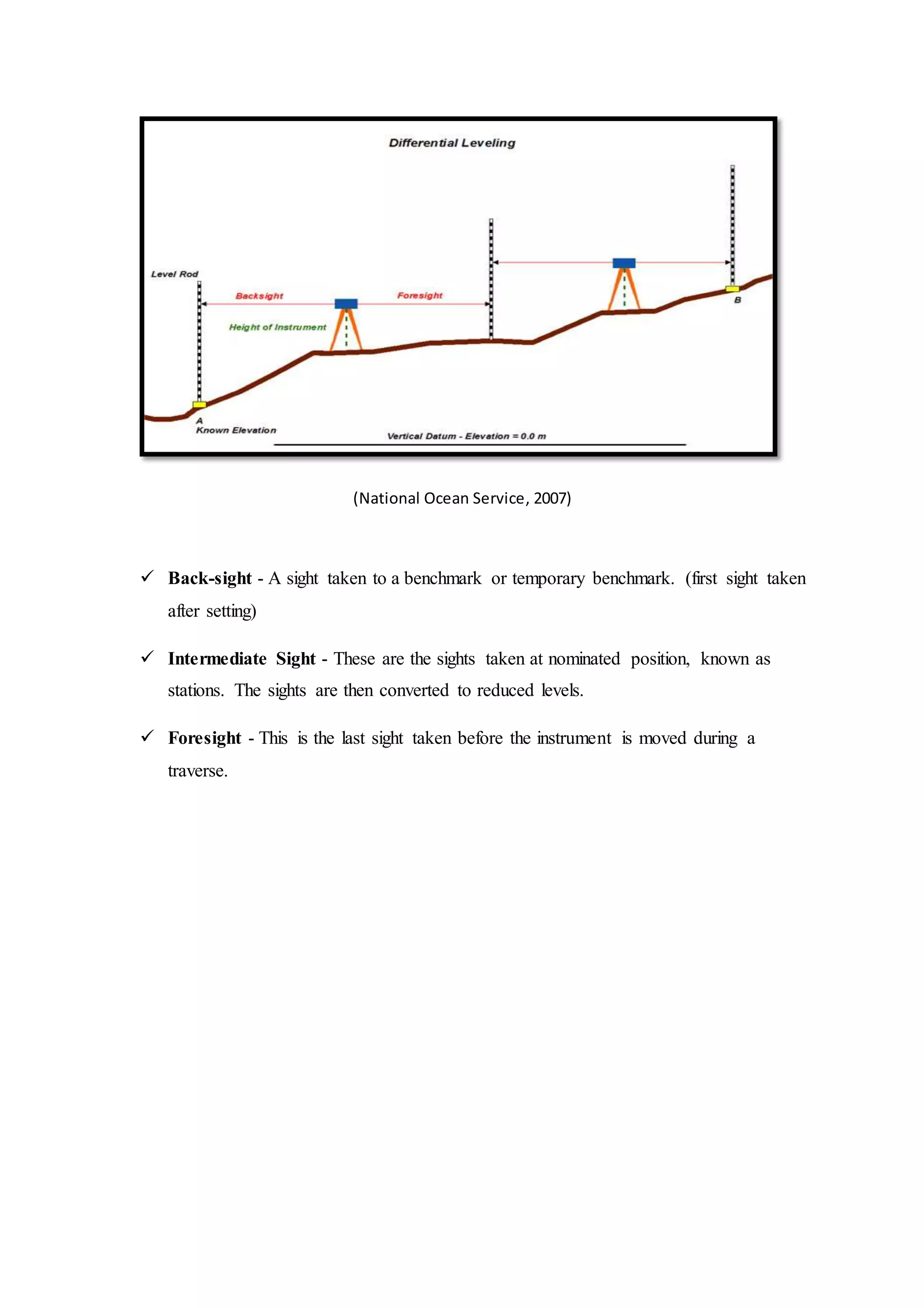
(National Ocean Service,2007)
Back-sight - A sight taken to a benchmark or temporary benchmark. (first sight taken
after setting)
Intermediate Sight - These are the sights taken at nominated position, known as
stations. The sights are then converted to reduced levels.
Foresight - This is the last sight taken before the instrument is moved during a
traverse.
6.
Objective
1. Find theelevation of a given point with respect to the given or assumed datum.
2. Establish a point at a given elevation with respect to the given or assumed datum.
3. To identify the spot relative height.
4. To identify possible errors occurred.
7.
Outline of Apparatus
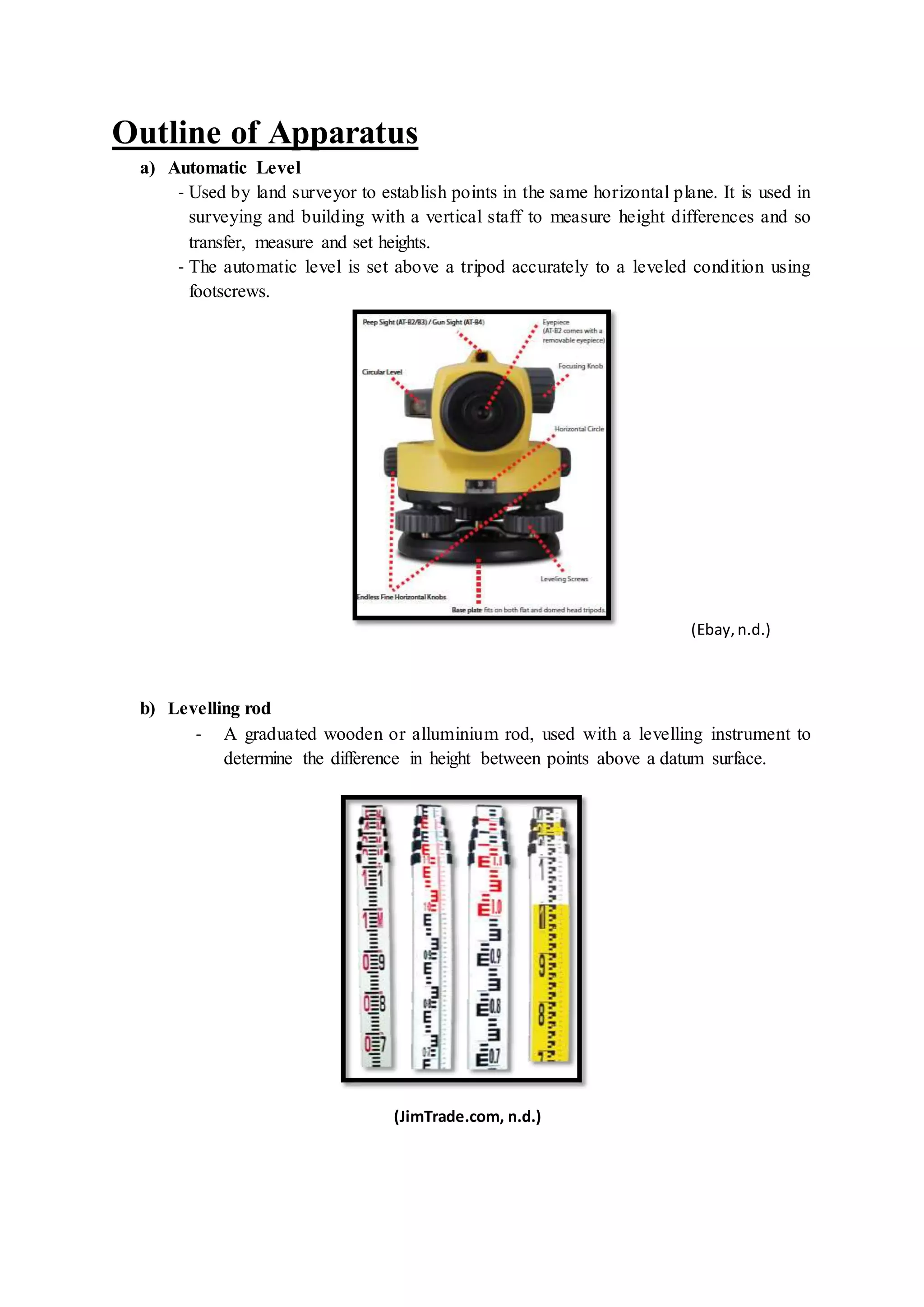
a)Automatic Level
- Used by land surveyor to establish points in the same horizontal plane. It is used in
surveying and building with a vertical staff to measure height differences and so
transfer, measure and set heights.
- The automatic level is set above a tripod accurately to a leveled condition using
footscrews.
(Ebay,n.d.)
b) Levelling rod
- A graduated wooden or alluminium rod, used with a levelling instrument to
determine the difference in height between points above a datum surface.
(JimTrade.com, n.d.)
8.
c) Adjustable leg-tripod
- Surveyor’s tripod is a device used to support any one of a number of surveying
instruments, such as automatic level.
- This tripods are more common in the construction world, especially outdoors
because of generally uneven surfaces.
(Ebay,n.d.)
d) Spirit Level
- An instrument designed to indicate whether a surface is horizontal or vertical.
Used in different type of instruments carry by surveyors.
(leveldevelopments, n.d.)
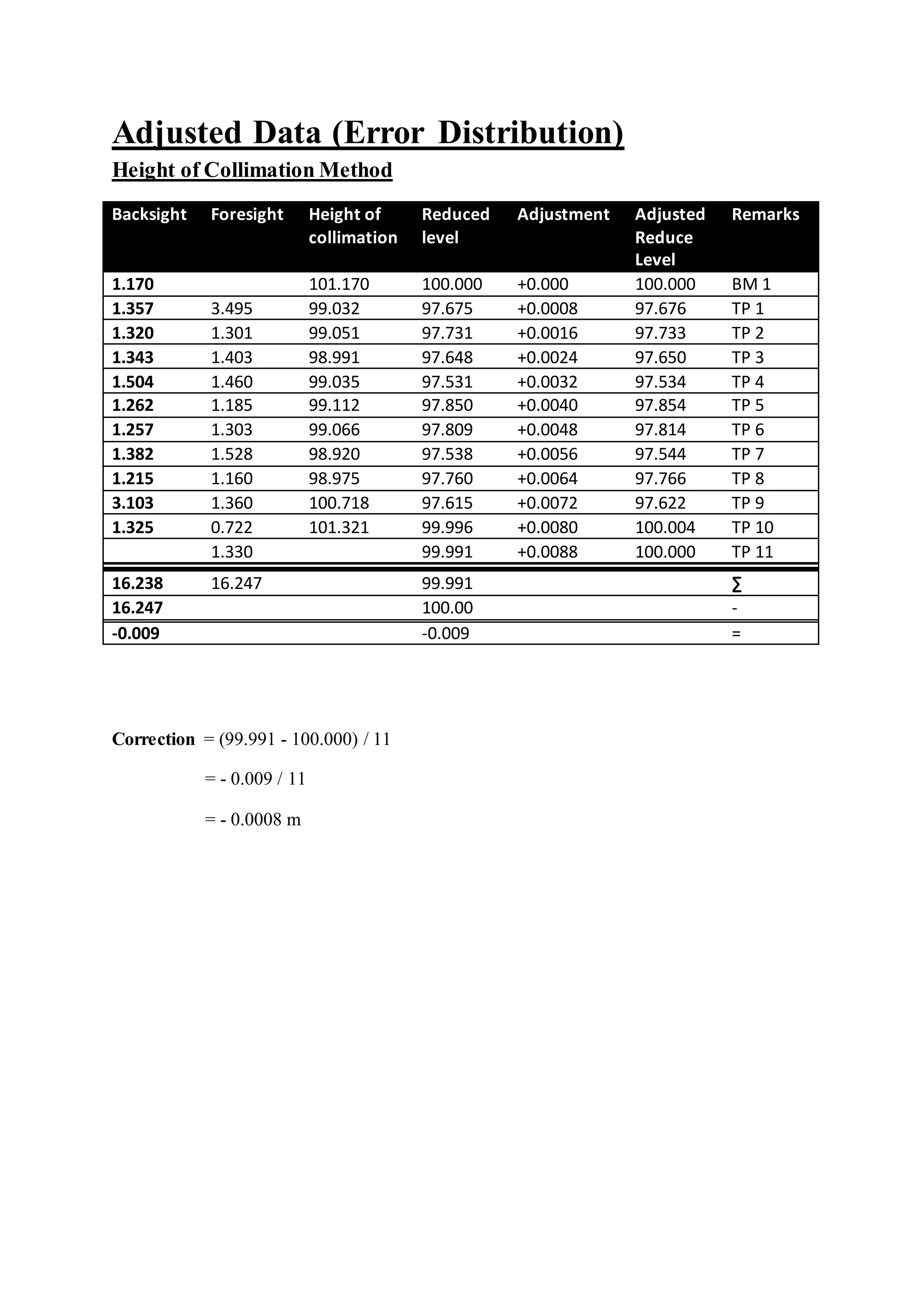
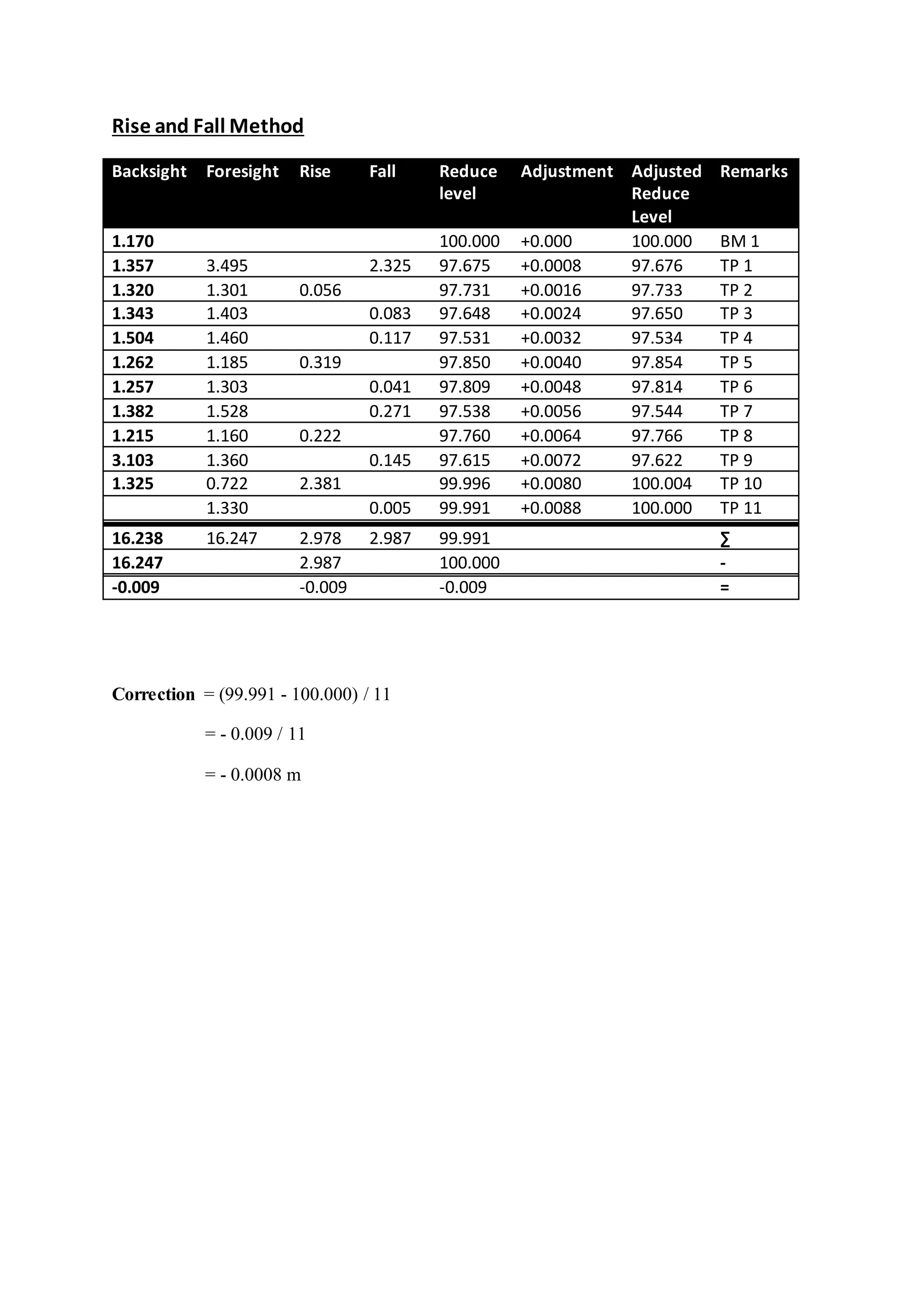
Discussion
In this fieldwork, the reduce level of the Bench Mark (BM) 1 is given which is
100.000m. Therefore, the reading of the backsight (BS) and the reading of the foresight (FS)
are measured and recorded through the levelling process. This process is repeated for 10
times by shifting the auto level from one point to another point at the site.
After obtaining the field data, we used both methods which are the height of
collimation method and rise and fall method to calculate the reduce level of each station. For
rise and fall method, the sum of the back-sights minus the sum of the foresights is equal to
the sum of the rises minus the sum of the falls, and is also equal to the last reduced level
minus the first reduce level. While for the height of collimation method, the sum of the back-
sights minus the sum of the foresights is equal to the last reduce level minus the first reduce
level.
However, in this data, the final reduce level is less than the initial reduce level. Thus,
there are some of the errors occurred during the levelling process. In this case, we can use
error distribution method to adjust the reduce level result.
After we calculated the reading, the error of disclosure is -0.0008 and the maximum
allowable error of closure is +/- 39.799mm. Thus, our levelling is acceptable.
To distribute the error, the correction is calculated according to the number of the
instrument setups. The correction per setup is +0.0008 and is shown in the table provided in
the adjusted data section.
14.
Conclusion
In conclusion, wemanage to obtain the data needed by using the leveling equipment
provided by our lecturer. We did this fieldwork twice because the error of misclosure in our
first set of data was too large. Hence, we had decided to redo this fieldwork. Even though we
had to spend more time, but in the end we managed to obtain a set of data with acceptable
range of error of misclosure.
After identifying the errors are in an acceptable range, we did adjustments to the data
obtained by distributing the errors. We used both rise and fall method and height of
collimation method to calculate the reduced level of each staff station. Then, we are able to
complete our fieldwork report with this complete set of data.
15.
Reference
1.) Levelling andsurveying. (n.d.). Levelling and surveying. (Website) Retrieved from
http://moodle.najah.edu/pluginfile.php/47165/mod_resource/content/0/Levelling_2.pdf3
2.) Manchester 1824. (n.d.). Surveying: Using a level. (Website) Retrieve from
http://media.humanities.manchester.ac.uk/humanities/flash/HumeL046_FionaSmyth_SED_2/
surveying/surveying.html
3.) Engineersupply. (n.d.). automatic levels. (Website) Retrieved from
http://www.engineersupply.com/automatic-levels.aspx
4.) Dictionary of Construction.com. (n.d.). Leveling rod. (Website) Retrieved from
http://www.dictionaryofconstruction.com/definition/leveling-rod.html
5.) Environmental Field Techniques. (n.d.). Surveying 1: Differential Leveling. (Website)
Retrieved from http://www.colorado.edu/geography/courses/geog_2043_f01/lab01_4.html
6.) Encyclopaedia Britannica. (n.d.). Spirit Leval. (Website) Retrieved from
http://global.britannica.com/technology/spirit-level