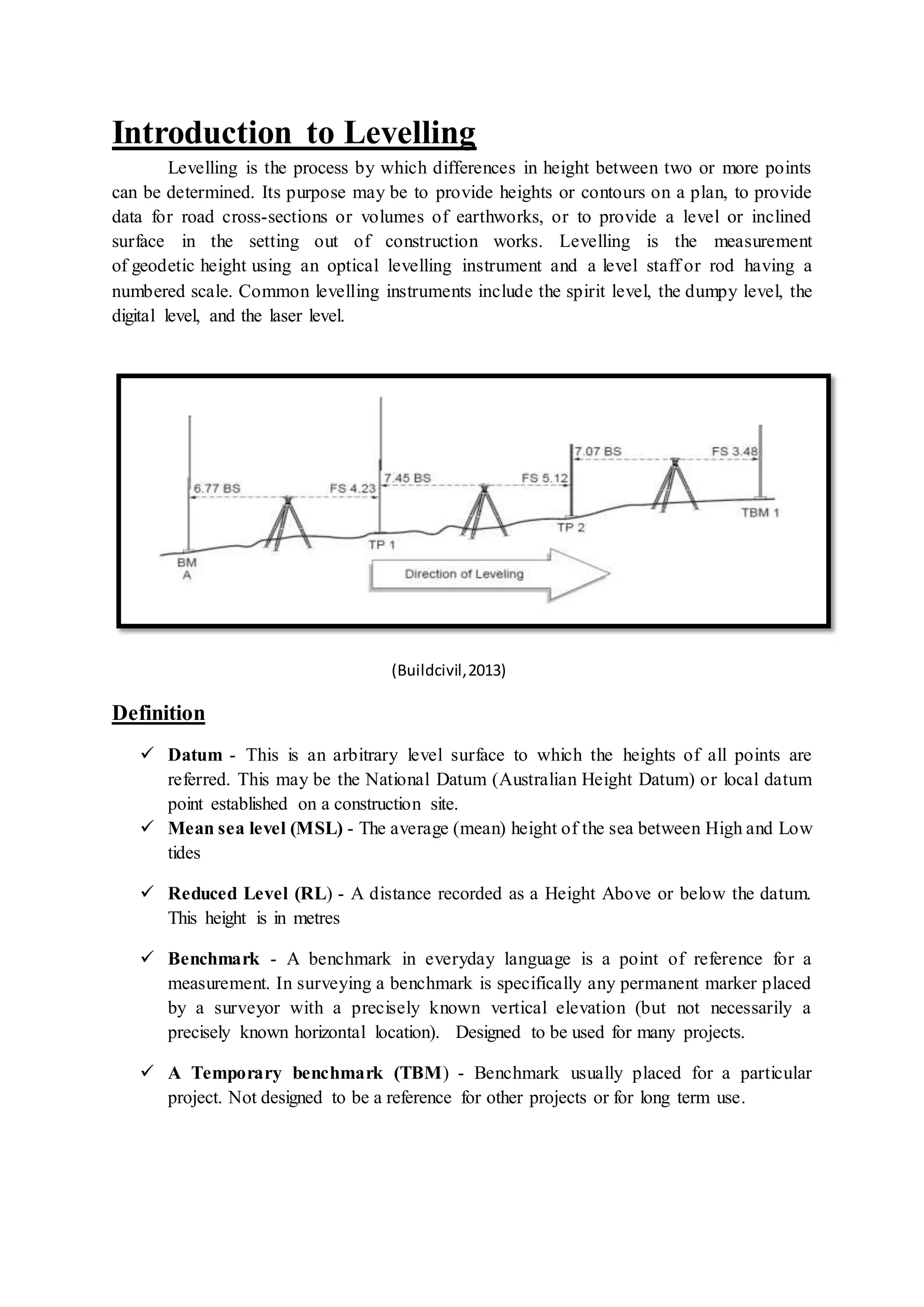
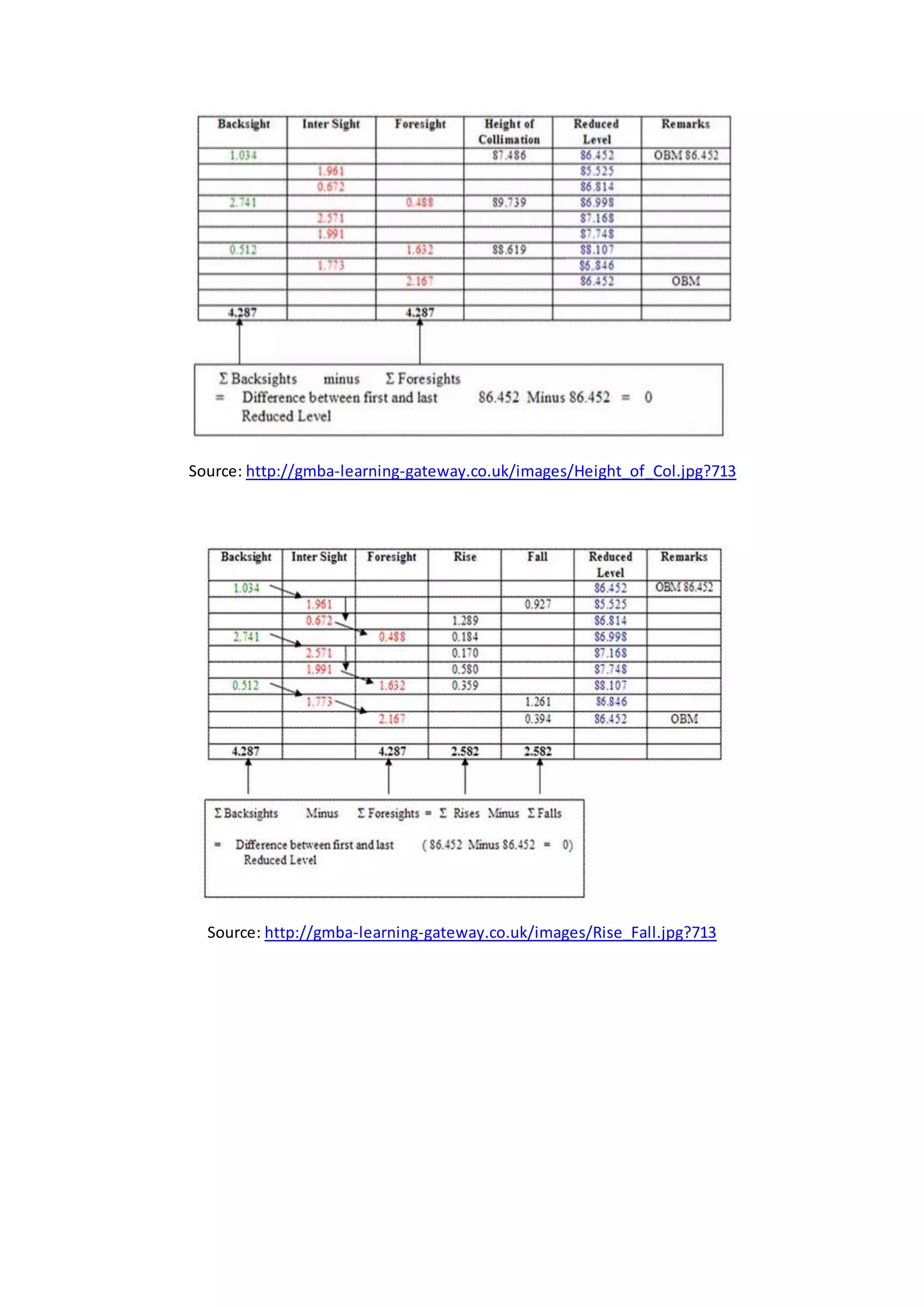
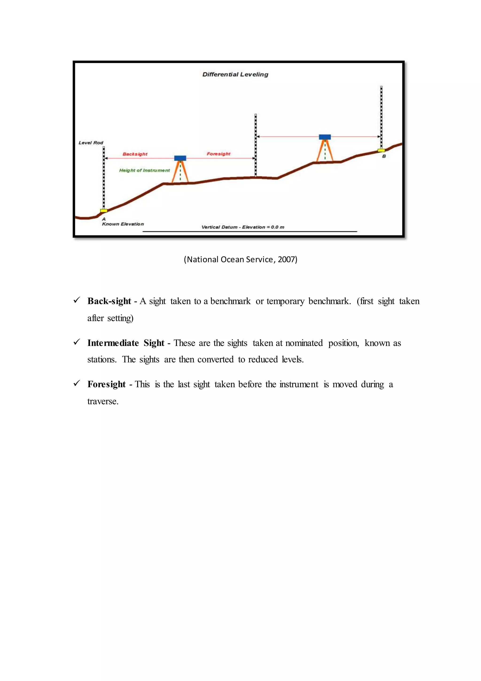
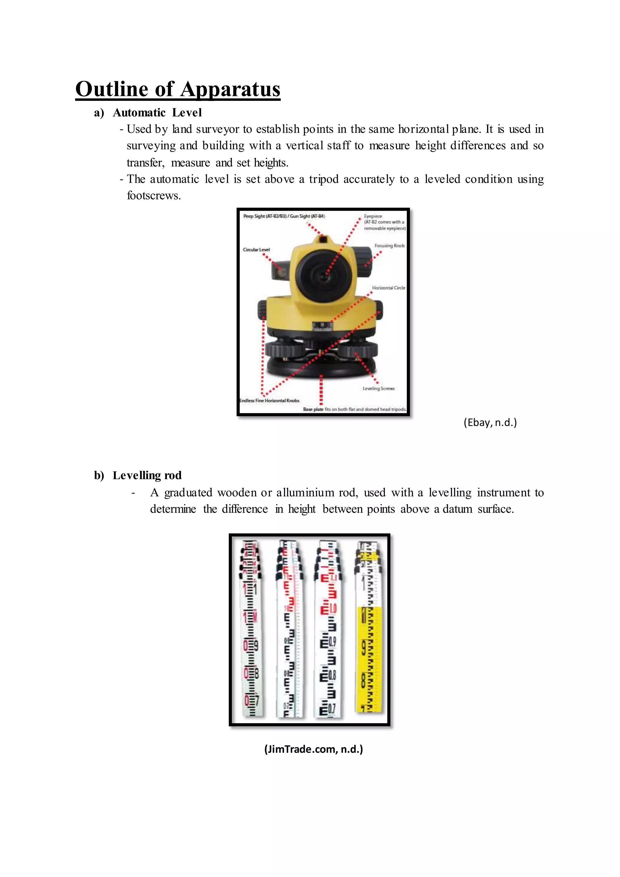
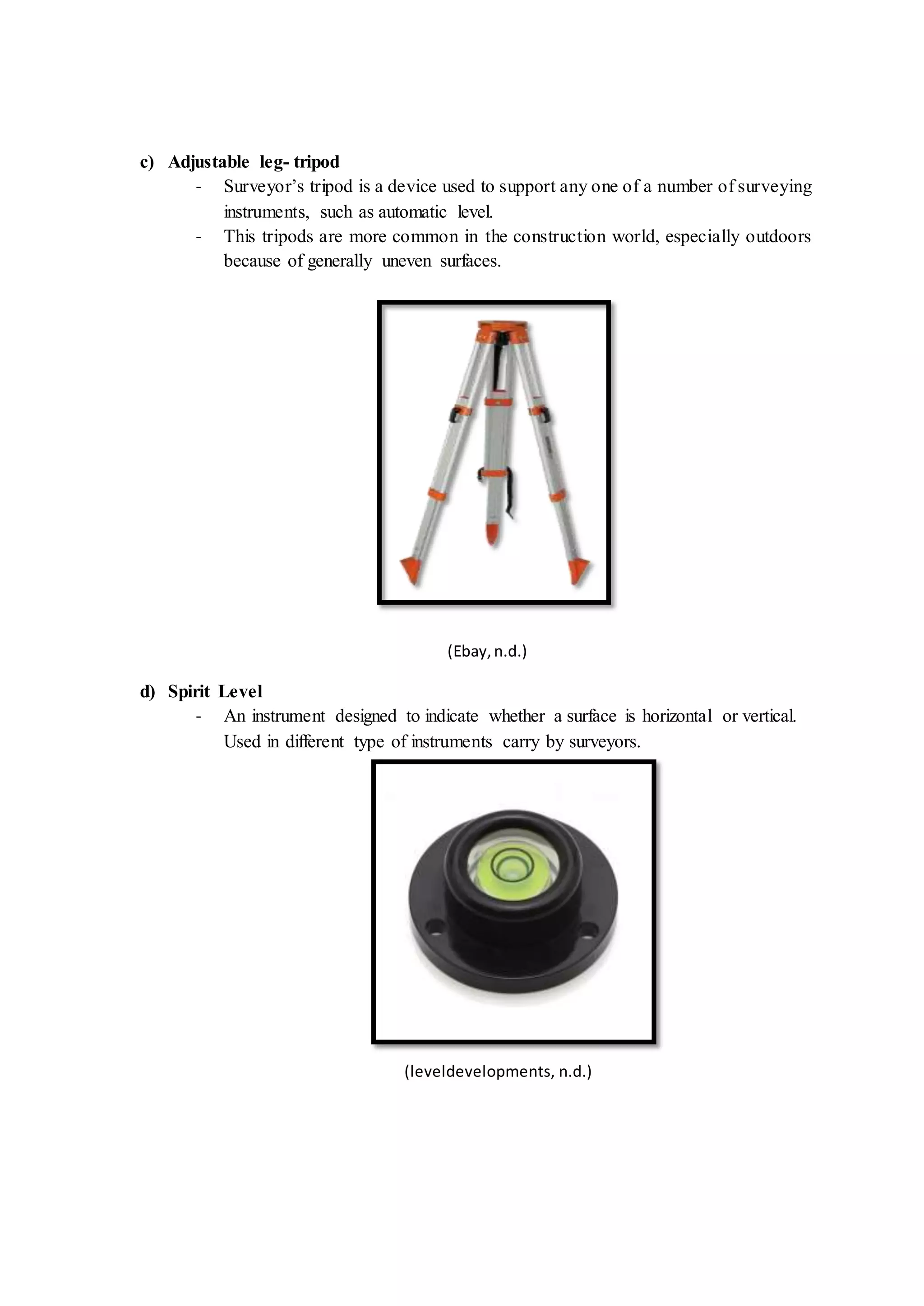
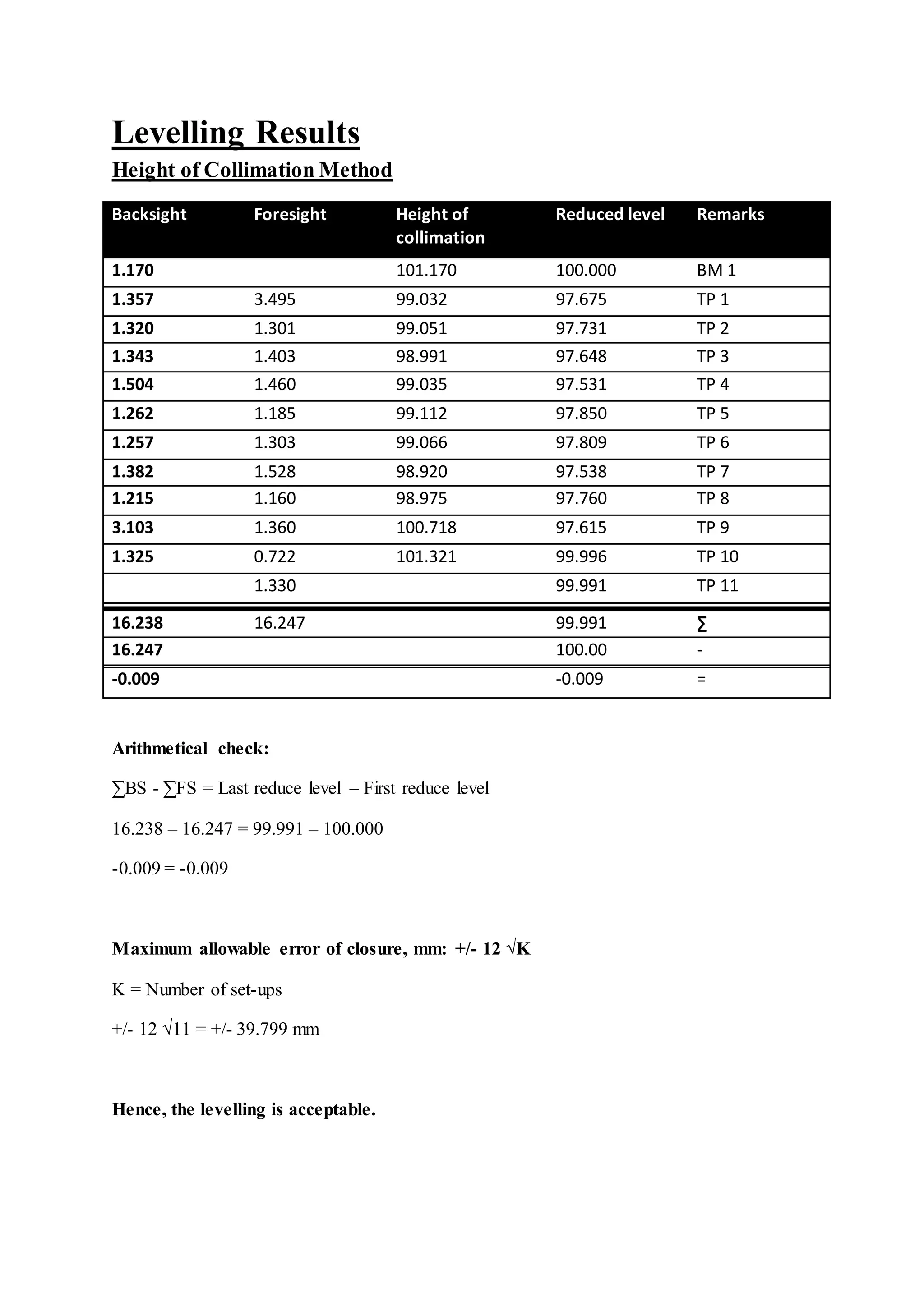
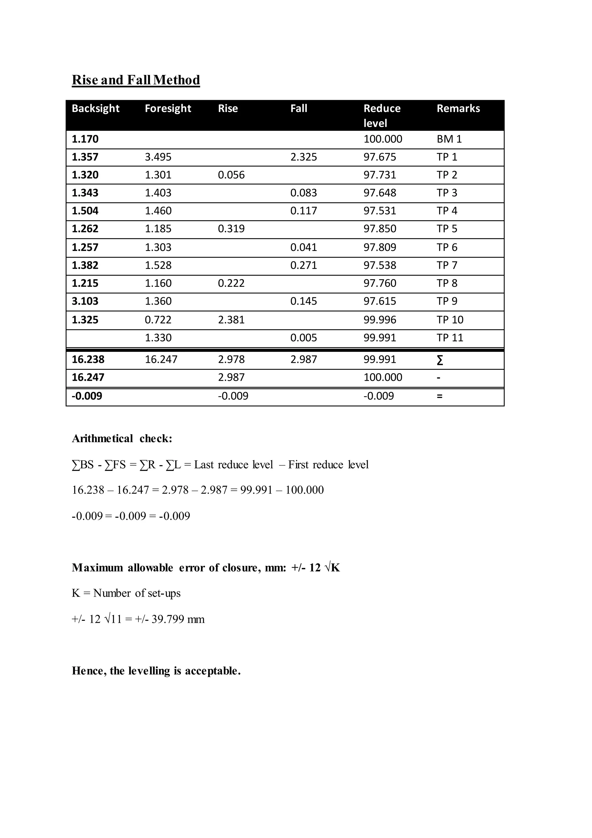
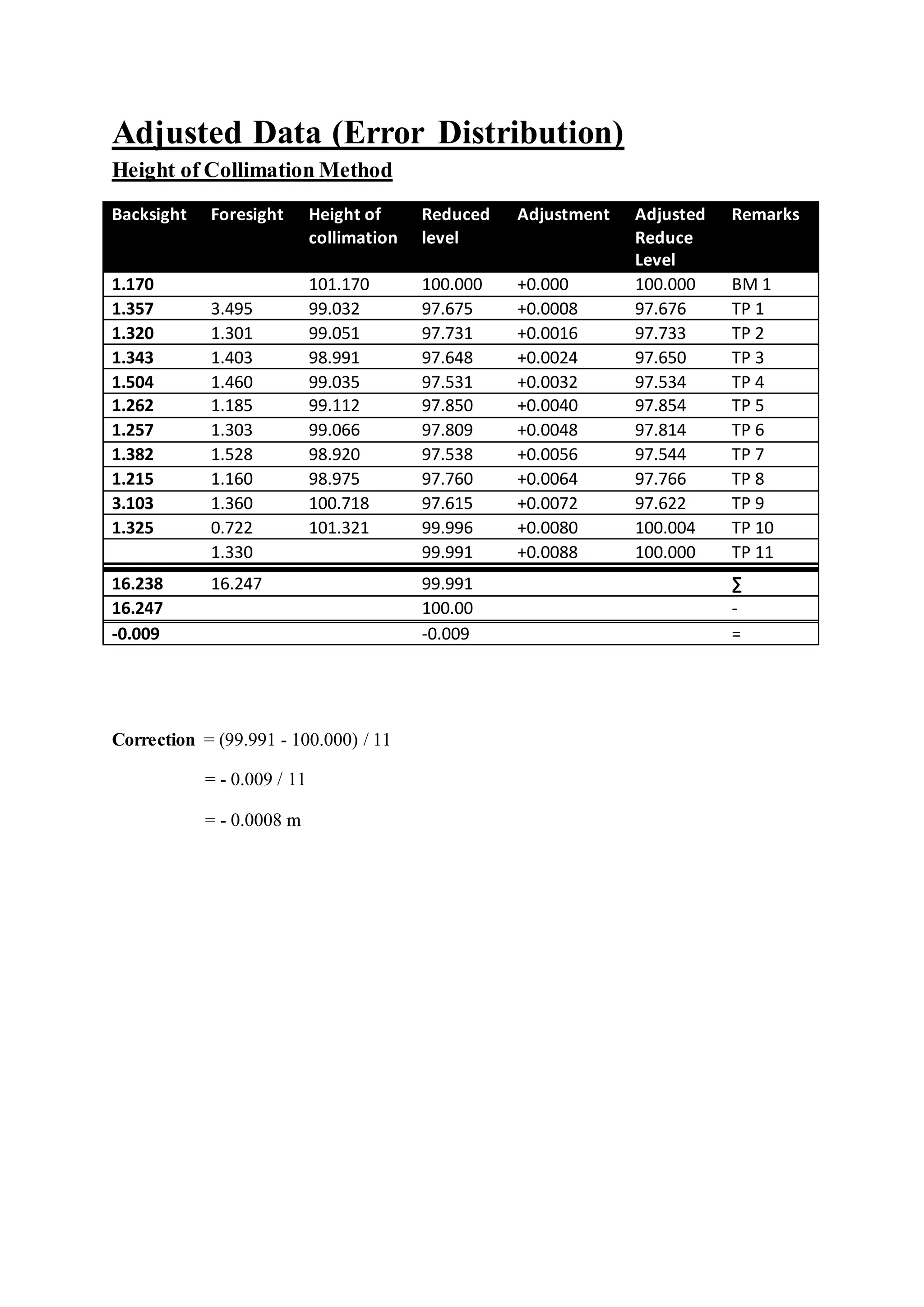
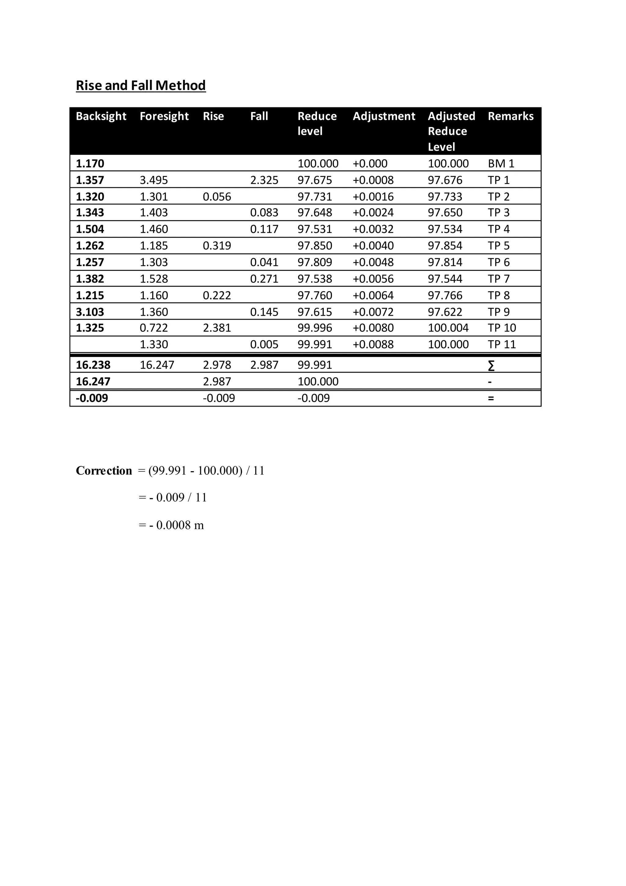
This document provides information about a fieldwork report for a site surveying course. It includes an introduction to levelling, the objective of the fieldwork, apparatus used including an automatic level, levelling rod, tripod and spirit level. Levelling results were presented using the height of collimation and rise/fall methods. Adjusted results were shown after distributing a small error. The levelling was found to be acceptable as the error of closure was within the allowed maximum. The document concluded the fieldwork was successfully completed to obtain data for the report.
Report Assignment 1 for Site Surveying module which requires us to do levelling measurement around the campus carpark, for the Bachelor of Quantity Surveying (BQS) Course Semester 2, Taylor's University Lakeside Campus
Course Contents:
Introduction; Linear measurements; Analysis and adjustment of measurements, Survey methods: coordinate systems, bearings, horizontal control, traversing, triangulation, detail surveying; Orientation and position; Areas and volumes; Setting out; Curve ranging; Global Positioning system (GPS); Photogrammetry.
Levelling in surveying is the process of determining the height of one level relative to another. It is used to establish the elevation of a point relative to a datum, or to establish a point at a given elevation relative to a datum
surveying Engineering
Fly Levelling
Fly leveling: -Fly leveling is just like differential leveling carried
out to check the accuracy of leveling work. It is a very approximate
form of leveling in which sights are taken as large as possible. in this
method, a line of levels is run to determine approximately reduced
levels of the points carried out with more rapidly and less precision
The aim of fly Levelling: The main purpose of this type of leveling is
to check the values of the reduced levels of the bench marks already
fixed. In this method only back sight and foresight are taken. There is no need of intermediate sights. However great care has to be taken for selecting the change points (Turning Points) and for taking reading on the change points because the accuracy of leveling depends upon these
-Create Bench Marks (BM).
Bench Marks
Bench Mark is a point of known elevation, there are three Type of Bench Marks
1-Perment Bench Mark.
2-Orbitrary Bench Mark .
3-Temporary Bench Mark .
-Leveling Process Calculation.
1. Height of collimation method
2. Rise and Fall method
How do we find horizontal distance using levelling Machine.
Fly Levelling Close loop survey.
Fly and Differential leveling Using (Rise & fall) and (HI)methods.
*Checks for Errors
-Misclosure
Allowable closing error
Where:
D =Distance in km
E = Misclosure error in (mm).
C = 30 for fixed levelling process in rough ground.
C = 15 for normal leveling in flat area (Good work)
Fly Levelling example
Computation of Elevations for an open loop survey H.I method
Computation of Elevations
Differential Leveling
Computation of Elevations
-Correction For Errors in Leveling
1. Errors Due to the line of sight being not horizontal
2. Error Due to Curvature and refraction.
Errors in differential leveling: -
1) Non adjustment of the instrument: -
a) Adjustment of cross-wire ring
b) Adjustment of the bubble tube
c) Adjustment of line of sight
2-Errors in levelling
• Collimation line
• Parallax
• Change point instability
• Instrument instability
• Benchmark instability
• Staff reading errors , • Staff verticality • Level Instrument shading • Temperature on staff • Booking errors) • Earth curvature • Refraction • The Bubble not center.
3-Constant error (instrumental error):
A. Non vertically of the staff.
B. Collimation error in the instrument.
C. Staff gradation error.
4- Random error (natural error):
A. Effect of wind and temperature.
B. Soft and hard ground.
C. Change points. CP
D. Human deficiencies and neglect
Prepared by:
Asst. Prof. Salar K.Hussein
Mr. Kamal Y.Abdullah
Asst.Lecturer. Dilveen H. Omar
Erbil Polytechnic University
Technical Engineering College
Civil Engineering Department
In the preparation for the Geodetic Engineering Licensure Examination, the BSGE students must memorized the fastest possible solution for the LEAST SQUARES ADJUSTMENT using casio fx-991 es plus calculator technique in order to save time during the said examination. note: lec 2 and above wala akong nilagay na solution para hindi makupya techniques ko. just add me on fb para ituro ko sa inyo solution. Kasi itong solution ko wala sa google, youtube, calc tech books at hindi rin itinuro sa review center.
New Explore Careers and College Majors 2024.pdfDr. Mary Askew
Explore Careers and College Majors is a new online, interactive, self-guided career, major and college planning system.
The career system works on all devices!
For more Information, go to https://bit.ly/3SW5w8W
The Impact of Artificial Intelligence on Modern Society.pdfssuser3e63fc
Just a game Assignment 3
1. What has made Louis Vuitton's business model successful in the Japanese luxury market?
2. What are the opportunities and challenges for Louis Vuitton in Japan?
3. What are the specifics of the Japanese fashion luxury market?
4. How did Louis Vuitton enter into the Japanese market originally? What were the other entry strategies it adopted later to strengthen its presence?
5. Will Louis Vuitton have any new challenges arise due to the global financial crisis? How does it overcome the new challenges?Assignment 3
1. What has made Louis Vuitton's business model successful in the Japanese luxury market?
2. What are the opportunities and challenges for Louis Vuitton in Japan?
3. What are the specifics of the Japanese fashion luxury market?
4. How did Louis Vuitton enter into the Japanese market originally? What were the other entry strategies it adopted later to strengthen its presence?
5. Will Louis Vuitton have any new challenges arise due to the global financial crisis? How does it overcome the new challenges?
This comprehensive program covers essential aspects of performance marketing, growth strategies, and tactics, such as search engine optimization (SEO), pay-per-click (PPC) advertising, content marketing, social media marketing, and more
135. Reviewer Certificate in Journal of Engineering
Project 1- Levelling
1. SCHOOL OF ARCHITECTURE • BUILDING • DESIGN
BACHELOR OF QUANTITY SURVEYING (HONOURS)
QSB 60103 – SITE SURVRYING
Fieldwork Report 1
Levelling
Name Student ID Marks
Yong Seen Yee 0315883
Yeoh Pooi Ching 0315540
Yee Algel 0315890
Yong Boon Xiong 0321754
2. Contents
Page
Introduction to Levelling ..........................................................................3
Objective.....................................................................................................6
Outline of Apparatus .................................................................................7
Levelling Results ..............................................................9
Adjusted Data (Error Distribution) ........................................................11
Discussion.................................................................................................13
Conclusion................................................................................................14
Reference ..................................................................................................15
3. Introduction to Levelling
Levelling is the process by which differences in height between two or more points
can be determined. Its purpose may be to provide heights or contours on a plan, to provide
data for road cross-sections or volumes of earthworks, or to provide a level or inclined
surface in the setting out of construction works. Levelling is the measurement
of geodetic height using an optical levelling instrument and a level staff or rod having a
numbered scale. Common levelling instruments include the spirit level, the dumpy level, the
digital level, and the laser level.
(Buildcivil,2013)
Definition
Datum - This is an arbitrary level surface to which the heights of all points are
referred. This may be the National Datum (Australian Height Datum) or local datum
point established on a construction site.
Mean sea level (MSL) - The average (mean) height of the sea between High and Low
tides
Reduced Level (RL) - A distance recorded as a Height Above or below the datum.
This height is in metres
Benchmark - A benchmark in everyday language is a point of reference for a
measurement. In surveying a benchmark is specifically any permanent marker placed
by a surveyor with a precisely known vertical elevation (but not necessarily a
precisely known horizontal location). Designed to be used for many projects.
A Temporary benchmark (TBM) - Benchmark usually placed for a particular
project. Not designed to be a reference for other projects or for long term use.
5. (National Ocean Service, 2007)
Back-sight - A sight taken to a benchmark or temporary benchmark. (first sight taken
after setting)
Intermediate Sight - These are the sights taken at nominated position, known as
stations. The sights are then converted to reduced levels.
Foresight - This is the last sight taken before the instrument is moved during a
traverse.
6. Objective
1. Find the elevation of a given point with respect to the given or assumed datum.
2. Establish a point at a given elevation with respect to the given or assumed datum.
3. To identify the spot relative height.
4. To identify possible errors occurred.
7. Outline of Apparatus
a) Automatic Level
- Used by land surveyor to establish points in the same horizontal plane. It is used in
surveying and building with a vertical staff to measure height differences and so
transfer, measure and set heights.
- The automatic level is set above a tripod accurately to a leveled condition using
footscrews.
(Ebay,n.d.)
b) Levelling rod
- A graduated wooden or alluminium rod, used with a levelling instrument to
determine the difference in height between points above a datum surface.
(JimTrade.com, n.d.)
8. c) Adjustable leg- tripod
- Surveyor’s tripod is a device used to support any one of a number of surveying
instruments, such as automatic level.
- This tripods are more common in the construction world, especially outdoors
because of generally uneven surfaces.
(Ebay,n.d.)
d) Spirit Level
- An instrument designed to indicate whether a surface is horizontal or vertical.
Used in different type of instruments carry by surveyors.
(leveldevelopments, n.d.)
13. Discussion
In this field work, the reduce level of the Bench Mark (BM) 1 is given which is
100.000m. Therefore, the reading of the backsight (BS) and the reading of the foresight (FS)
are measured and recorded through the levelling process. This process is repeated for 10
times by shifting the auto level from one point to another point at the site.
After obtaining the field data, we used both methods which are the height of
collimation method and rise and fall method to calculate the reduce level of each station. For
rise and fall method, the sum of the back-sights minus the sum of the foresights is equal to
the sum of the rises minus the sum of the falls, and is also equal to the last reduced level
minus the first reduce level. While for the height of collimation method, the sum of the back-
sights minus the sum of the foresights is equal to the last reduce level minus the first reduce
level.
However, in this data, the final reduce level is less than the initial reduce level. Thus,
there are some of the errors occurred during the levelling process. In this case, we can use
error distribution method to adjust the reduce level result.
After we calculated the reading, the error of disclosure is -0.0008 and the maximum
allowable error of closure is +/- 39.799mm. Thus, our levelling is acceptable.
To distribute the error, the correction is calculated according to the number of the
instrument setups. The correction per setup is +0.0008 and is shown in the table provided in
the adjusted data section.
14. Conclusion
In conclusion, we manage to obtain the data needed by using the leveling equipment
provided by our lecturer. We did this fieldwork twice because the error of misclosure in our
first set of data was too large. Hence, we had decided to redo this fieldwork. Even though we
had to spend more time, but in the end we managed to obtain a set of data with acceptable
range of error of misclosure.
After identifying the errors are in an acceptable range, we did adjustments to the data
obtained by distributing the errors. We used both rise and fall method and height of
collimation method to calculate the reduced level of each staff station. Then, we are able to
complete our fieldwork report with this complete set of data.
15. Reference
1.) Levelling and surveying. (n.d.). Levelling and surveying. (Website) Retrieved from
http://moodle.najah.edu/pluginfile.php/47165/mod_resource/content/0/Levelling_2.pdf3
2.) Manchester 1824. (n.d.). Surveying: Using a level. (Website) Retrieve from
http://media.humanities.manchester.ac.uk/humanities/flash/HumeL046_FionaSmyth_SED_2/
surveying/surveying.html
3.) Engineersupply. (n.d.). automatic levels. (Website) Retrieved from
http://www.engineersupply.com/automatic-levels.aspx
4.) Dictionary of Construction.com. (n.d.). Leveling rod. (Website) Retrieved from
http://www.dictionaryofconstruction.com/definition/leveling-rod.html
5.) Environmental Field Techniques. (n.d.). Surveying 1: Differential Leveling. (Website)
Retrieved from http://www.colorado.edu/geography/courses/geog_2043_f01/lab01_4.html
6.) Encyclopaedia Britannica. (n.d.). Spirit Leval. (Website) Retrieved from
http://global.britannica.com/technology/spirit-level