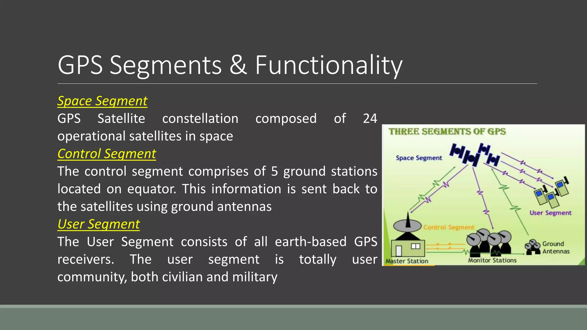
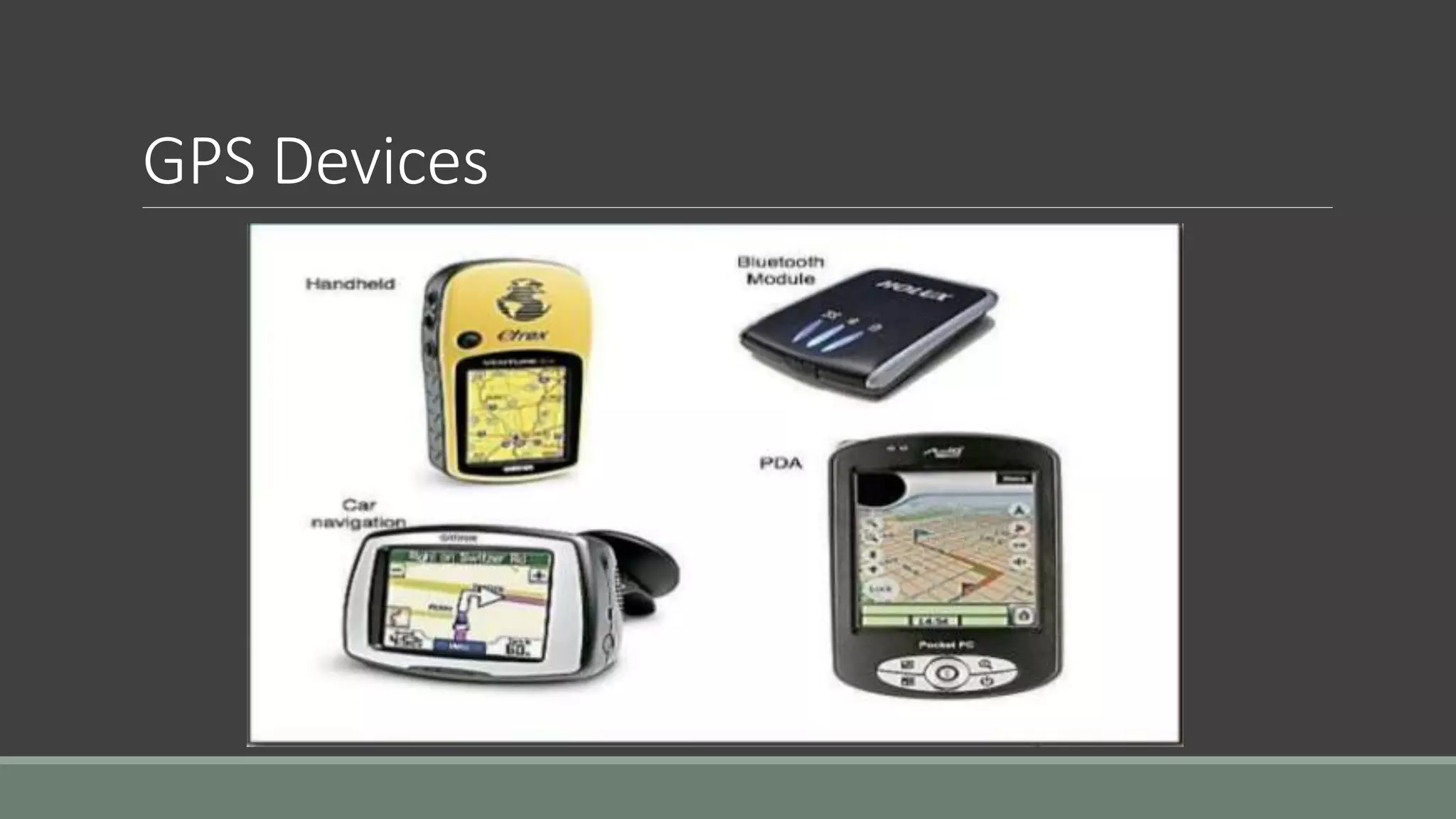
2. What is GPS
The Global Positioning System (GPS) is a satellite-based Navigation
system which shows you your exact position on earth anytime,
anywhere
GPS is the shortened form of NAVSTAR GPS
This is an acronym for NAVigation System with Time And Ranging
Global Positioning System
GPS uses constellation of 24 satellites to determine the accurate
three - dimensional position of the user on the earth
GPS was originally designed for military use at any time anywhere
on the surface of the earth but soon after proposals it is made
available to civilian users also
Mainly used for navigation, map making, surveying etc.
3. Evolution of GPS
The GPS project was proposed in 1973 to overcome the limitations of earlier navigation systems
It was created by the US department of Defense and was originally run with 24 satellites known
as satellite constellation
First satellite was launched in 1978 but It became fully operational with launching of 24th
satellite in 1995
Advances in technology and new demands on the existing system have now led to efforts to
modernize the GPS system and implement the next generation of GPS III satellites
In addition to GPS of US, other systems are also in use or under development, like
RUSSIAN’s - Global Navigation Satellite System (GLONASS)
EUROPEAN’s - Galileo Positioning System
INDIA’s - Indian Regional Navigational Satellite System
CHINA’s - Compass Navigation System but these systems are suffered from incomplete
coverage of the globe and failed to provide the accurate information
4. GPS Satellites
There are quite a number of satellites out there in space. They are used for a
wide range of purposes: satellite TV, cellular phones, military purposes and etc.
Satellites can also be used by GPS receivers
GPS Satellites: The GPS Operational Constellation consists of 24 satellites that
orbit the Earth in very precise orbits twice a day. GPS satellites emit continuous
navigation signals
5. Working of GPS
A GPS receiver can tell its own position by using the position data of itself, and
compares that data with 3 or more GPS satellites
To get the distance to each satellite, the GPS
transmits a signal to each satellite.
- The signal travels at a known speed
- The system measures the time delay
between the signal transmission and signal
reception of the GPS signal
- The signals carry information about the
satellite’s location
- Determines the position of, and distance
to, at least three satellites
- The receiver computes position using
TRIANGULATION
6. Working of GPS (Contd..)
The GPS uses technique of "triangulation" to find
location
To "triangulate," a GPS receiver measures distance
from the satellite using the travel time of radio signals
To measure travel time, GPS needs very
accurate timing, which is provided by atomic
clocks used in the satellites
Along with distance, we need to know exactly
where the satellites are in space
Finally we must correct for any delays the
signal experiences as it travels through the atmosphere
To compute a positions in three dimensions.
We need to have four satellite measurements.
The GPS uses a trigonometric approach to calculate
the positions
7. GPS Segments & Functionality
GPS Systems has three segments:
1.Space Segment (SS)
2.Control Segment (CS)
3.User Segment (US)
8. GPS Segments & Functionality
Space Segment
GPS Satellite constellation composed of 24
operational satellites in space
Control Segment
The control segment comprises of 5 ground stations
located on equator. This information is sent back to
the satellites using ground antennas
User Segment
The User Segment consists of all earth-based GPS
receivers. The user segment is totally user
community, both civilian and military
11. Errors in GPS
The receiver is not synchronized with the atomic clock in the satellite
The estimate of the position of the satellite
Speed of light is only constant in vacuum
“Multi path errors” : Ghost signals from reflected radio waves
“Selective availability (SA)”: Added noise from department of defense
Not free sight to many enough satellites
Noise in the receiver
12. Advantages of GPS
GPS is extremely easy to navigate as it tells
you to the direction for each turns you take or
you have to take to reach to your destination
GPS works in all weather so you need not to
worry of the climate as in other navigating
systems
The GPS costs you very low.
The most attractive feature of this system is
its100% coverage on the planet
It also helps you to search the nearby
restaurants, hotels and gas stations and is
very useful for a new place
Due to its low cost, it is very easy to integrate
into other technologies like cell phone
The system is updated regularly by the US
government (as compared to other
navigations systems by other countries e.g.
GLONASS) and hence is very advance
This is the best navigating system in water as
in larger water bodies we are often misled
due to lack of proper directions
Accuracy can vary from millimeters to several
meters depending on the technique that is
used
13. Disadvantages of GPS
GPS satellite signals are weak, so it doesn't work as well indoors, underwater,
under trees, etc.
The highest accuracy requires line-of-sight from the receiver to the satellite, this
is why GPS doesn't work very well in an urban environment
The US DoD (dept. of defence) can, at any time, deny users use of the system
(i.e. they degrade/shut down the satellites)
If you are using GPS on a battery operated device, there may be a battery
failure and you may need a external power supply which is not always possible
Sometimes the GPS signals are not accurate due to some obstacles to the
signals
14. Applications of GPS
Military
Target Tracking: Tracking potential ground and
air targets before flagging them as hostile
Navigation
Missile and Projectile Guidance: Allows
accurate targeting of various military
weapons including cruise missiles and
precision-guided munitions
Reconnaissance
Search and Rescue: Downed pilots can be
located faster if their position is known
Civilian
Geotagging: Applying location coordinates to
digital objects such as photographs and other
documents
Disaster Relief / Emergency Services
Vehicle Tracking Systems
GPS Aircraft Tracking
Telematics: GPS technology integrated with
computer and mobile communication
technology in automotive navigation systems
Two major applications of GPS are Military and Civilian
15. Some other Applications..
Railway Systems
Recreational Activities
Weather Prediction
Skydiving
And many more…
16. Conclusion
GPS is a network of satellites that continuously transmit coded
information, which makes it possible to precisely identify locations
on earth by measuring distance from the satellites
GPS although was developed for military purposes, but the number
of civilian users of GPS already well far exceeds than number of
potential military
As discussed in previous topic, its application field is vast and new
applications will continue to be created as the technology evolves