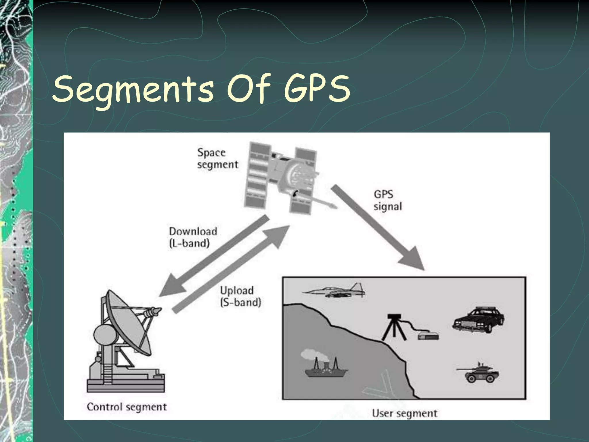
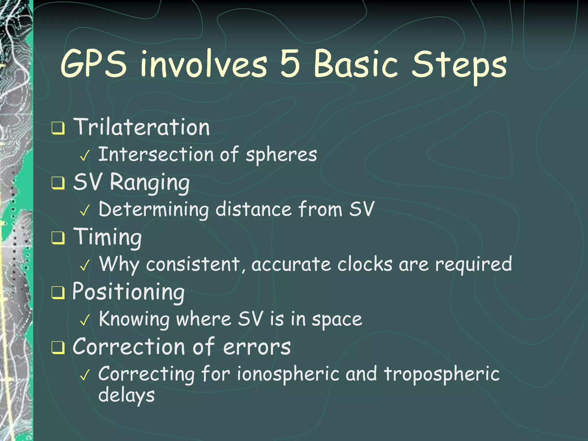
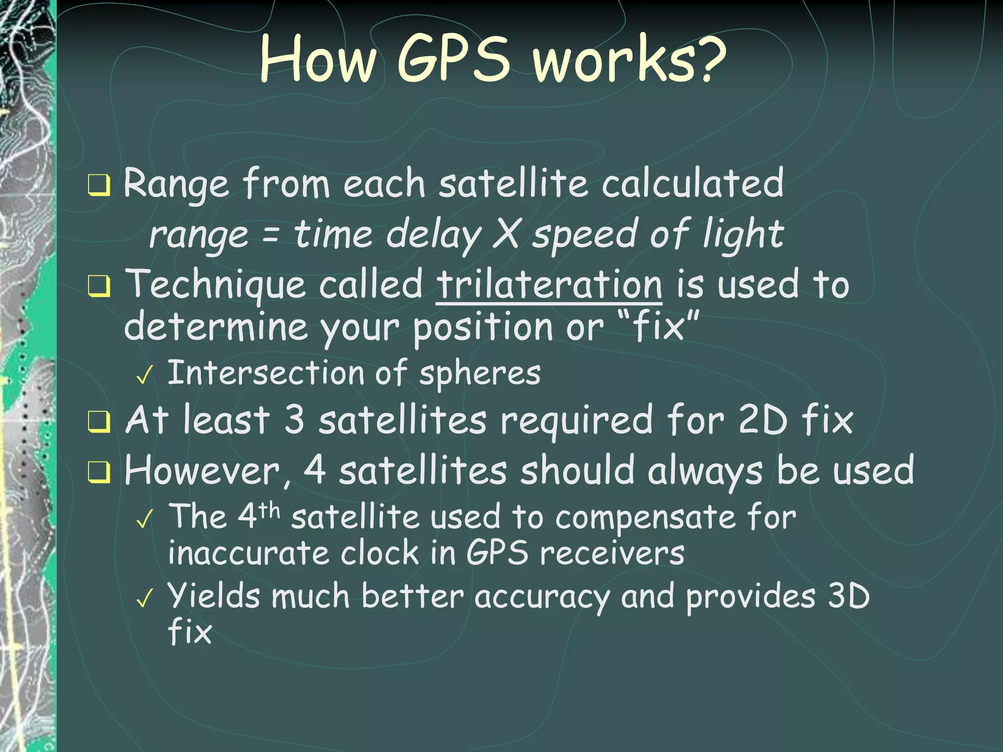
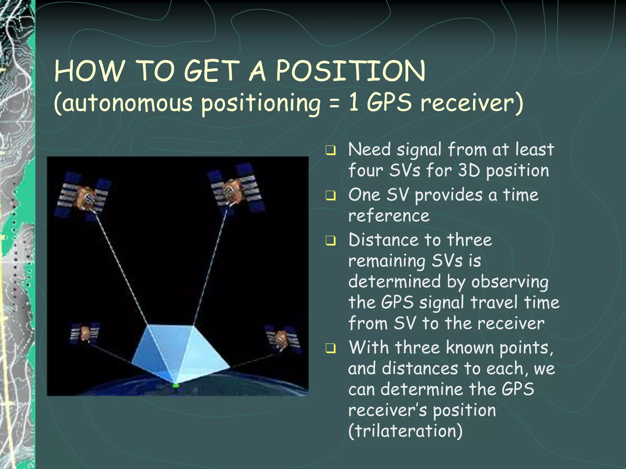
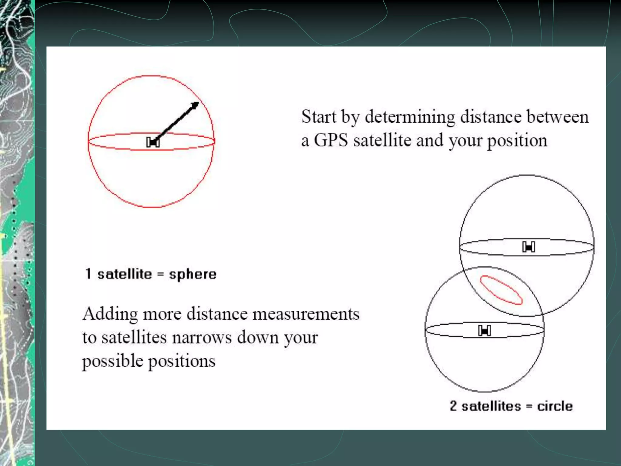
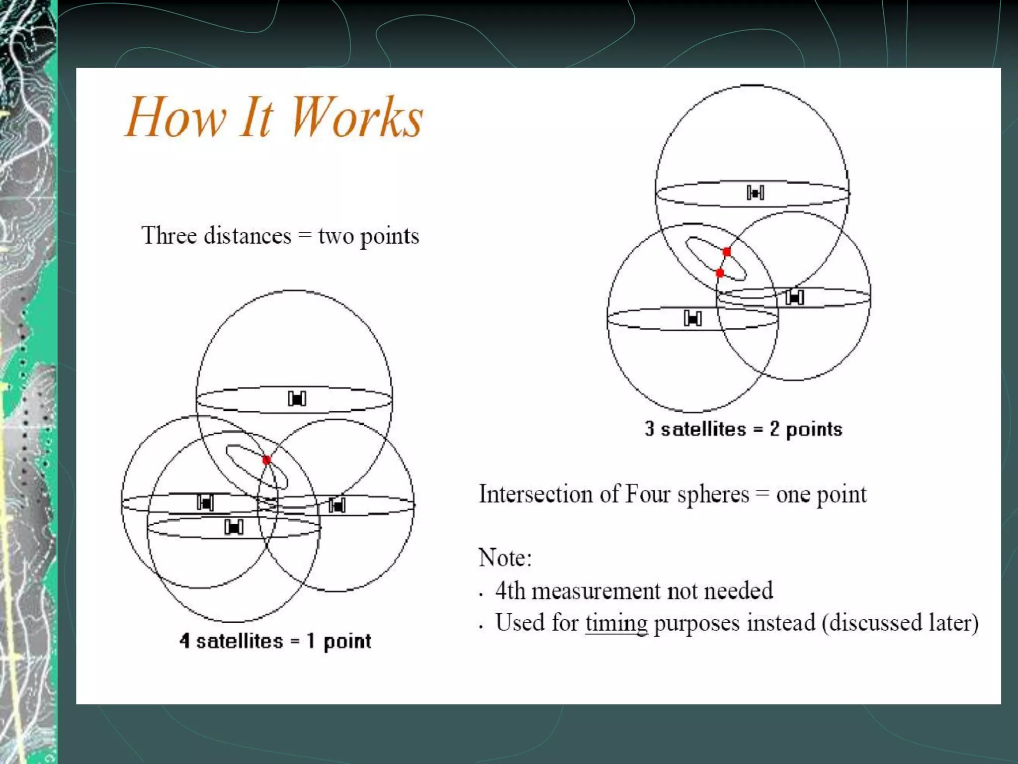
GPS Overview
Presented By: Sakib, Md. Sadman
ID: 13-23482-1
What is GPS?
❑ GPS(Global Positioning System) is a type of
GNSS(Global Nevegation Satellite system).
❑ It allows small electronic receivers to determine
the latitude,longitude and altitude of a point.
❑ It uses time signals transmitted along a line of
sight by radio from satellites.
❑ Receivers calculate the precise time as well as
position, which can be used as a reference for
scientific experiments.
❑ GPS uses 24 Medium Earth Orbit satellites (
altitude of about 20,000 kms above the surface of
the earth.
What is GPS?
❑ Radio-based navigation system developed by
✓ Initial operation in 1993
✓ Fully operational in 1995
❑ System is called NAVSTAR
✓ NAVigation with Satellite Timing And Ranging
✓ Referred to as GPS
❑ Series of 24 satellites, 6 orbital planes, 4 satellite
vehicles (SV) on each plane
❑ Works anywhere in the world, 24 hours a day, in all
weather conditions and provides:
✓ Location or positional fix
✓ Velocity
✓ Direction of travel
✓ Accurate time
Global Navigation Satellite Systems
(GNSS)
❑ NAVSTAR
✓ USA
❑ GLONASS
✓ Russians
❑ Galileo
✓ Europeans
Segments Of GPS
❑ Trilateration
✓ Intersection of spheres
❑ SV Ranging
✓ Determining distance from SV
❑ Timing
✓ Why consistent, accurate clocks are required
❑ Positioning
✓ Knowing where SV is in space
❑ Correction of errors
✓ Correcting for ionospheric and tropospheric
delays
GPS involves 5 Basic Steps
How GPS works?
❑ Range from each satellite calculated
range = time delay X speed of light
❑ Technique called trilateration is used to
determine your position or “fix”
✓ Intersection of spheres
❑ At least 3 satellites required for 2D fix
❑ However, 4 satellites should always be used
✓ The 4th satellite used to compensate for
inaccurate clock in GPS receivers
✓ Yields much better accuracy and provides 3D
fix
HOW TO GET A POSITION
(autonomous positioning = 1 GPS receiver)
❑ Need signal from at least
four SVs for 3D position
❑ One SV provides a time
reference
❑ Distance to three
remaining SVs is
determined by observing
the GPS signal travel time
from SV to the receiver
❑ With three known points,
and distances to each, we
can determine the GPS
receiver’s position
(trilateration)
Application Of GPS
Engineering applications
❑ Avionic navigation( autopilot
system) including precision
landing and route correction.
❑ Navigation for ships and boats.
Used by drivers to locate
shipwrecks.
❑ Land and hydrographic
surveying, including topological
surveying, seismic surveys and
rig positioning.
❑ Precise positioning including
bridge section, mining machinery
, construction .
❑ Used in ADC (Anti Collision
Device) in local train system.
Others applications
❑ Vehicle tracking , including in-
car navigation , fleet tracking,
fishing vessel tracking.
❑ Moving maps in automobiles.
❑ Used for trekking , hiking , and
in sports ( to measure exact
speed , distance , time and
altitude ).
❑ Tracking the migratory patterns
of birds , fishes , and animals.
❑ Personal traker. Also used in
security operations.
Advantages and Disadvatages of GPS
Advantages
❑ Ease of use.
❑ Accurate , efficient and
absolute recording of position.
❑ High accuracy from remote
location.
❑ A portable and handy tracking
device. Can be used in watches
and hand held devices.
❑ Can be integrated easily with
other communication devices like
mobiles and laptops.
❑ No set up charges.
Disadvantages
❑ Heavy reliance on GPS system.
❑ Ambiguity : GPS signals are not
always accurate. Signals are
affected by reflection from
buildings.
❑ Large cost of maintaining the
satellites.
❑ Geomagnetic storms caused by
solar activity.
❑ The devices are not affordable
to all. Also there is additional
noise and interference in
environment .
❑ Terrorism.
Future Scope
❑ The cell phones are increasingly
incorporating GPS technology.
❑ GPS devices in cars will soon be a
commonplace.
❑ 3-D modeling technology in GPS for
anticipating vehicular traffic.
❑ Controlling other devices using your
cell phone.
Psa final presentation on gps ....for Rethwan Faiz sir

Psa final presentation on gps ....for Rethwan Faiz sir

  • 1.
    GPS Overview Presented By:Sakib, Md. Sadman ID: 13-23482-1
  • 2.
    What is GPS? ❑GPS(Global Positioning System) is a type of GNSS(Global Nevegation Satellite system). ❑ It allows small electronic receivers to determine the latitude,longitude and altitude of a point. ❑ It uses time signals transmitted along a line of sight by radio from satellites. ❑ Receivers calculate the precise time as well as position, which can be used as a reference for scientific experiments. ❑ GPS uses 24 Medium Earth Orbit satellites ( altitude of about 20,000 kms above the surface of the earth.
  • 3.
    What is GPS? ❑Radio-based navigation system developed by ✓ Initial operation in 1993 ✓ Fully operational in 1995 ❑ System is called NAVSTAR ✓ NAVigation with Satellite Timing And Ranging ✓ Referred to as GPS ❑ Series of 24 satellites, 6 orbital planes, 4 satellite vehicles (SV) on each plane ❑ Works anywhere in the world, 24 hours a day, in all weather conditions and provides: ✓ Location or positional fix ✓ Velocity ✓ Direction of travel ✓ Accurate time
  • 4.
    Global Navigation SatelliteSystems (GNSS) ❑ NAVSTAR ✓ USA ❑ GLONASS ✓ Russians ❑ Galileo ✓ Europeans
  • 5.
  • 6.
    ❑ Trilateration ✓ Intersectionof spheres ❑ SV Ranging ✓ Determining distance from SV ❑ Timing ✓ Why consistent, accurate clocks are required ❑ Positioning ✓ Knowing where SV is in space ❑ Correction of errors ✓ Correcting for ionospheric and tropospheric delays GPS involves 5 Basic Steps
  • 7.
    How GPS works? ❑Range from each satellite calculated range = time delay X speed of light ❑ Technique called trilateration is used to determine your position or “fix” ✓ Intersection of spheres ❑ At least 3 satellites required for 2D fix ❑ However, 4 satellites should always be used ✓ The 4th satellite used to compensate for inaccurate clock in GPS receivers ✓ Yields much better accuracy and provides 3D fix
  • 8.
    HOW TO GETA POSITION (autonomous positioning = 1 GPS receiver) ❑ Need signal from at least four SVs for 3D position ❑ One SV provides a time reference ❑ Distance to three remaining SVs is determined by observing the GPS signal travel time from SV to the receiver ❑ With three known points, and distances to each, we can determine the GPS receiver’s position (trilateration)
  • 11.
    Application Of GPS Engineeringapplications ❑ Avionic navigation( autopilot system) including precision landing and route correction. ❑ Navigation for ships and boats. Used by drivers to locate shipwrecks. ❑ Land and hydrographic surveying, including topological surveying, seismic surveys and rig positioning. ❑ Precise positioning including bridge section, mining machinery , construction . ❑ Used in ADC (Anti Collision Device) in local train system. Others applications ❑ Vehicle tracking , including in- car navigation , fleet tracking, fishing vessel tracking. ❑ Moving maps in automobiles. ❑ Used for trekking , hiking , and in sports ( to measure exact speed , distance , time and altitude ). ❑ Tracking the migratory patterns of birds , fishes , and animals. ❑ Personal traker. Also used in security operations.
  • 12.
    Advantages and Disadvatagesof GPS Advantages ❑ Ease of use. ❑ Accurate , efficient and absolute recording of position. ❑ High accuracy from remote location. ❑ A portable and handy tracking device. Can be used in watches and hand held devices. ❑ Can be integrated easily with other communication devices like mobiles and laptops. ❑ No set up charges. Disadvantages ❑ Heavy reliance on GPS system. ❑ Ambiguity : GPS signals are not always accurate. Signals are affected by reflection from buildings. ❑ Large cost of maintaining the satellites. ❑ Geomagnetic storms caused by solar activity. ❑ The devices are not affordable to all. Also there is additional noise and interference in environment . ❑ Terrorism.
  • 13.
    Future Scope ❑ Thecell phones are increasingly incorporating GPS technology. ❑ GPS devices in cars will soon be a commonplace. ❑ 3-D modeling technology in GPS for anticipating vehicular traffic. ❑ Controlling other devices using your cell phone.