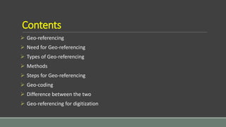
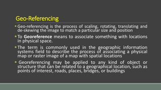
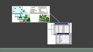
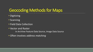
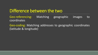
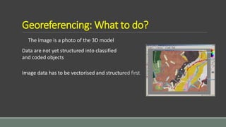
Geo-Referencing & Geo-Coding
Contents
 Geo-referencing
 Need for Geo-referencing
 Types of Geo-referencing
 Methods
 Steps for Geo-referencing
 Geo-coding
 Difference between the two
 Geo-referencing for digitization
Geo-Referencing
 Geo-referencing is the process of scaling, rotating, translating and
de-skewing the image to match a particular size and position
To Georeference means to associate something with locations
in physical space.
The term is commonly used in the geographic information
systems field to describe the process of associating a physical
map or raster image of a map with spatial locations
 Georeferencing may be applied to any kind of object or
structure that can be related to a geographical location, such as
points of interest, roads, places, bridges, or buildings
Need for Geo-referencing
Geo-reference is used when establishing the relation between raster
or vector images by determining the spatial location of the
geographical features
This procedure is mandatory for data modeling in the field of
geographic information systems (GIS)
When data from different sources or time periods (like time series
satellite images) need to be combined and then used in a GIS
application, (e.g. for change detection, assess damages after a
natural disaster etc.), it becomes essential to have a common
referencing system
Types of Geo-referencing
Two types:
1.Geo-referencing Raster Images
2.Geo-referencing Vector Data
Geo-referencing Raster Images
 A crucial element of any mapping project is registering a map with the correct
real world coordinates. This procedure is called geo-referencing. If the maps
are not geo-referenced, no other information can be displayed over or
positioned under the map coverage.
 Depending on the source materials and the specifications of the project, maps
can be registered to either a coordinate system or to another base map such as
a digital ortho photo.
Geo-referencing Vector Data
Vector data can be geo-referenced (or rubber sheeted) to
real world coordinates. Vector data can be either rubber
sheeted to match existing base maps or the data may be
projected into a specific coordinate system.
Geo-Coding
 Geocoding is the conversion of Geo-refencing (spatial information)
into digital form
 Geocoding involves capturing the map, and sometimes also
capturing the attributes
 Assigning spatial coordinates to point data
Geocoding Methods for Maps
 Digitizing
 Scanning
 Field Data Collection
 Vector and Raster
In ArcView Feature Data Source, Image Data Source
 Often involves address matching
Difference between the two
Geo-referencing: Matching geographic images to
coordinates
Geo-coding: Matching addresses to geographic coordinates
(latitude & longitude)
Geo-referencing for Digitization
What is digitization?
Capturing data by converting features on a paper map or (digital) aerial
photograph into digital vector format
Methods
Method Devices
Manual digitising • Coordinate entry via keyboard
• Digitising tablet with cursor
• Mouse cursor on the computer
monitor: on screen digitising (heads-up)
• Digital photogrammetry
Automatic digitising • Scanner
Semi-automatic
digitising
• Scanner and line-following software
The image is a photo of the 3D model
Georeferencing: What to do?
Data are not yet structured into classified
and coded objects
Image data has to be vectorised and structured first
Conclusion
Used to convert the entire map onto a real-world co-ordinate system
With Georeferencing you can align geographic data to a known coordinate
system so it can be viewed, queried, and analyzed with other geographic data
Geocoding is a GIS operation for converting street addresses into spatial data
that can be displayed as features on a map, usually by referencing address
information from a street segment data layer

Geo referencing by Mashhood Arif

  • 1.
  • 2.
    Contents  Geo-referencing  Needfor Geo-referencing  Types of Geo-referencing  Methods  Steps for Geo-referencing  Geo-coding  Difference between the two  Geo-referencing for digitization
  • 3.
    Geo-Referencing  Geo-referencing isthe process of scaling, rotating, translating and de-skewing the image to match a particular size and position To Georeference means to associate something with locations in physical space. The term is commonly used in the geographic information systems field to describe the process of associating a physical map or raster image of a map with spatial locations  Georeferencing may be applied to any kind of object or structure that can be related to a geographical location, such as points of interest, roads, places, bridges, or buildings
  • 4.
    Need for Geo-referencing Geo-referenceis used when establishing the relation between raster or vector images by determining the spatial location of the geographical features This procedure is mandatory for data modeling in the field of geographic information systems (GIS) When data from different sources or time periods (like time series satellite images) need to be combined and then used in a GIS application, (e.g. for change detection, assess damages after a natural disaster etc.), it becomes essential to have a common referencing system
  • 5.
    Types of Geo-referencing Twotypes: 1.Geo-referencing Raster Images 2.Geo-referencing Vector Data
  • 6.
    Geo-referencing Raster Images A crucial element of any mapping project is registering a map with the correct real world coordinates. This procedure is called geo-referencing. If the maps are not geo-referenced, no other information can be displayed over or positioned under the map coverage.  Depending on the source materials and the specifications of the project, maps can be registered to either a coordinate system or to another base map such as a digital ortho photo.
  • 7.
    Geo-referencing Vector Data Vectordata can be geo-referenced (or rubber sheeted) to real world coordinates. Vector data can be either rubber sheeted to match existing base maps or the data may be projected into a specific coordinate system.
  • 8.
    Geo-Coding  Geocoding isthe conversion of Geo-refencing (spatial information) into digital form  Geocoding involves capturing the map, and sometimes also capturing the attributes  Assigning spatial coordinates to point data
  • 10.
    Geocoding Methods forMaps  Digitizing  Scanning  Field Data Collection  Vector and Raster In ArcView Feature Data Source, Image Data Source  Often involves address matching
  • 11.
    Difference between thetwo Geo-referencing: Matching geographic images to coordinates Geo-coding: Matching addresses to geographic coordinates (latitude & longitude)
  • 12.
    Geo-referencing for Digitization Whatis digitization? Capturing data by converting features on a paper map or (digital) aerial photograph into digital vector format Methods Method Devices Manual digitising • Coordinate entry via keyboard • Digitising tablet with cursor • Mouse cursor on the computer monitor: on screen digitising (heads-up) • Digital photogrammetry Automatic digitising • Scanner Semi-automatic digitising • Scanner and line-following software
  • 13.
    The image isa photo of the 3D model Georeferencing: What to do? Data are not yet structured into classified and coded objects Image data has to be vectorised and structured first
  • 14.
    Conclusion Used to convertthe entire map onto a real-world co-ordinate system With Georeferencing you can align geographic data to a known coordinate system so it can be viewed, queried, and analyzed with other geographic data Geocoding is a GIS operation for converting street addresses into spatial data that can be displayed as features on a map, usually by referencing address information from a street segment data layer