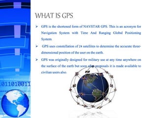
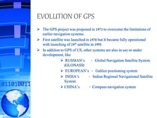
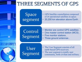
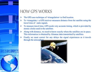
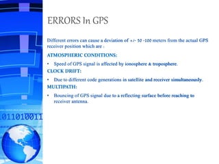
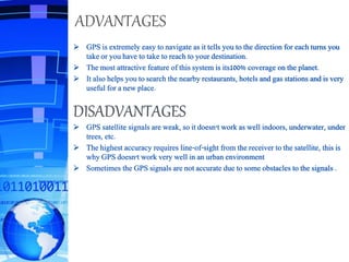
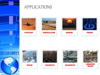
Submitedby,
ADITYAGHOSH
ARGHAYAGOSWAMI
PritamSardar
PROHLADMONDAL
DEPT OF E.C.E
SWAMI VIVEKANANDA INSTITUTE OF SCIENCE & TECHNOLOGY
 WHAT IS GPS
 EVOLUTION OF GPS
 THREE SEGMENTS OF GPS
 HOW GPS WORKS
 ERRORS IN GPS
 ADVANTAGES & DISADVANTAGES
 APPLICATIONS
 CONCLUSION
 BIBILIOGRAPHY
WHAT IS GPS
 GPS is the shortened form of NAVSTAR GPS. This is an acronym for
Navigation System with Time And Ranging Global Positioning
System.
 GPS uses constellation of 24 satellites to determine the accurate three-
dimensional position of the user on the earth.
 GPS was originally designed for military use at any time anywhere on
the surface of the earth but soon after proposals it is made available to
civilian users also.
EVOLUTION OF GPS
 The GPS project was proposed in 1973 to overcome the limitations of
earlier navigation systems.
 First satellite was launched in 1978 but It became fully operational
with launching of 24th satellite in 1995.
 In addition to GPS of US, other systems are also in use or under
development, like
 RUSSIAN’s - Global Navigation Satellite System
(GLONASS)
 EUROPEAN’s - Galileo positioning system
 INDIA’s - Indian Regional Navigational Satellite
System
 CHINA’s - Compass navigation system
• GPS Satellite constellation composed
of 24 operational satellites in space.
• 20,200 km elevation above Earth .
Space
segment
• Monitor are control GPS satellites .
• One master control station (MCS) .
• Five monitor stations .
• Three ground antennas .
Control
Segment
• The User Segment consists of all
earth-based GPS receivers.
• The user segment is totally user
community, both civilian and military.
User
Segment
HOW GPS WORKS
 The GPS uses technique of "triangulation" to find location.
 To "triangulate," a GPS receiver measures distance from the satellite using the
travel time of radio signals.
 To measure travel time, GPS needs very accurate timing, which is provided by
atomic clocks used in the satellites.
 Along with distance, we need to know exactly where the satellites are in space.
This information is obtained by Almanac data transmitted by satellites.
 Finally we must correct for any delays the signal experiences as it travels
through the atmosphere.
ERRORS In GPS
Different errors can cause a deviation of +/- 50 -100 meters from the actual GPS
receiver position which are :
ATMOSPHERIC CONDITIONS:
• Speed of GPS signal is affected by ionosphere & troposphere.
CLOCK DRIFT:
• Due to different code generations in satellite and receiver simultaneously.
MULTIPATH:
• Bouncing of GPS signal due to a reflecting surface before reaching to
receiver antenna.
ADVANTAGES
 GPS is extremely easy to navigate as it tells you to the direction for each turns you
take or you have to take to reach to your destination.
 The most attractive feature of this system is its100% coverage on the planet.
 It also helps you to search the nearby restaurants, hotels and gas stations and is very
useful for a new place.
DISADVANTAGES
 GPS satellite signals are weak, so it doesn't work as well indoors, underwater, under
trees, etc.
 The highest accuracy requires line-of-sight from the receiver to the satellite, this is
why GPS doesn't work very well in an urban environment
 Sometimes the GPS signals are not accurate due to some obstacles to the signals .
APPLICATIONS
AVIATION AGRICULUTRE MARINE TIMING
SPACE RAILWAYS ROADWAYS
DISASTER
RELIEF
CONCLUSION
 GPS is a network of satellites that continuously transmit coded
information, which makes it possible to precisely identify locations
on earth by measuring distance from the satellites.
 GPS although was developed for military purposes, but the number of
civilian users of GPS already well far exceeds than number of
potential military .
 As discussed in previous topic, its application field is vast and new
applications will continue to be created as the technology evolves.
BIBLIOGRAPHY
 http://www.gpsinformation.net
 http://www.aiigps.com
 http://garmin.com
 http://colorado.edu/geography/gcraft/notes/gps
 http://trimble.com
 www.wikipedia.com/globalpositioingsystem
Global positioning system(GPS)

Global positioning system(GPS)

  • 1.
  • 2.
     WHAT ISGPS  EVOLUTION OF GPS  THREE SEGMENTS OF GPS  HOW GPS WORKS  ERRORS IN GPS  ADVANTAGES & DISADVANTAGES  APPLICATIONS  CONCLUSION  BIBILIOGRAPHY
  • 3.
    WHAT IS GPS GPS is the shortened form of NAVSTAR GPS. This is an acronym for Navigation System with Time And Ranging Global Positioning System.  GPS uses constellation of 24 satellites to determine the accurate three- dimensional position of the user on the earth.  GPS was originally designed for military use at any time anywhere on the surface of the earth but soon after proposals it is made available to civilian users also.
  • 4.
    EVOLUTION OF GPS The GPS project was proposed in 1973 to overcome the limitations of earlier navigation systems.  First satellite was launched in 1978 but It became fully operational with launching of 24th satellite in 1995.  In addition to GPS of US, other systems are also in use or under development, like  RUSSIAN’s - Global Navigation Satellite System (GLONASS)  EUROPEAN’s - Galileo positioning system  INDIA’s - Indian Regional Navigational Satellite System  CHINA’s - Compass navigation system
  • 5.
    • GPS Satelliteconstellation composed of 24 operational satellites in space. • 20,200 km elevation above Earth . Space segment • Monitor are control GPS satellites . • One master control station (MCS) . • Five monitor stations . • Three ground antennas . Control Segment • The User Segment consists of all earth-based GPS receivers. • The user segment is totally user community, both civilian and military. User Segment
  • 6.
    HOW GPS WORKS The GPS uses technique of "triangulation" to find location.  To "triangulate," a GPS receiver measures distance from the satellite using the travel time of radio signals.  To measure travel time, GPS needs very accurate timing, which is provided by atomic clocks used in the satellites.  Along with distance, we need to know exactly where the satellites are in space. This information is obtained by Almanac data transmitted by satellites.  Finally we must correct for any delays the signal experiences as it travels through the atmosphere.
  • 7.
    ERRORS In GPS Differenterrors can cause a deviation of +/- 50 -100 meters from the actual GPS receiver position which are : ATMOSPHERIC CONDITIONS: • Speed of GPS signal is affected by ionosphere & troposphere. CLOCK DRIFT: • Due to different code generations in satellite and receiver simultaneously. MULTIPATH: • Bouncing of GPS signal due to a reflecting surface before reaching to receiver antenna.
  • 8.
    ADVANTAGES  GPS isextremely easy to navigate as it tells you to the direction for each turns you take or you have to take to reach to your destination.  The most attractive feature of this system is its100% coverage on the planet.  It also helps you to search the nearby restaurants, hotels and gas stations and is very useful for a new place. DISADVANTAGES  GPS satellite signals are weak, so it doesn't work as well indoors, underwater, under trees, etc.  The highest accuracy requires line-of-sight from the receiver to the satellite, this is why GPS doesn't work very well in an urban environment  Sometimes the GPS signals are not accurate due to some obstacles to the signals .
  • 9.
    APPLICATIONS AVIATION AGRICULUTRE MARINETIMING SPACE RAILWAYS ROADWAYS DISASTER RELIEF
  • 10.
    CONCLUSION  GPS isa network of satellites that continuously transmit coded information, which makes it possible to precisely identify locations on earth by measuring distance from the satellites.  GPS although was developed for military purposes, but the number of civilian users of GPS already well far exceeds than number of potential military .  As discussed in previous topic, its application field is vast and new applications will continue to be created as the technology evolves.
  • 11.
    BIBLIOGRAPHY  http://www.gpsinformation.net  http://www.aiigps.com http://garmin.com  http://colorado.edu/geography/gcraft/notes/gps  http://trimble.com  www.wikipedia.com/globalpositioingsystem