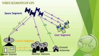
SlideShare a Scribd company logo
1 of 22
GLOBAL POSITIONING SYSTEM
OVERVIEW
 WHAT IS GPS
 EVOLUTION OF GPS
 THREE SEGMENTS OF GPS
 INFORMATION IN A GPS SIGNAL
 HOW GPS WORKS
 DIFFERENTIAL GPS
 GPS FREQENCIES
 APPLICATIONS
 ADVANTAGES
 DISADVANTAGES
 CONCLUSION
WHAT IS GPS
 The Global Positioning System (GPS) is a satellite-based Navigation system developed
and operated by the US Department of Defense.
 GPS is the shortened form of NAVSTAR GPS. This is an acronym for NAVigation
System with Time And Ranging Global Positioning System.
 GPS uses constellation of 24 satellites to determine the accurate three-dimensional
position of the user on the earth.
 GPS was originally designed for military use at any time anywhere on the surface of the
earth but soon after proposals it is made available to civilian users also.
 It cost about $750 million to manage and maintain the system per year.
EVOLUTION OF GPS
 The GPS project was proposed in 1973 to overcome the limitations of earlier navigation
systems.
 First satellite was launched in 1978 but It became fully operational with launching of 24th
satellite in 1995.
 Advances in technology and new demands on the existing system have now led to efforts to
modernize the GPS system and implement the next generation of GPS III satellites.
 it became fully operanational in 1995. “Bradford Parkinson”, “Roger L. Easton”,
and “Ivan A. Getting” are credited with inventing it.
 In addition to GPS of US, other systems are also in use or under development, like
 RUSSIAN’s - Global Navigation Satellite System (GLONASS)
 EUROPEAN’s - Galileo positioning system
 INDIA’s - Indian Regional Navigational Satellite System
 CHINA’s - Compass navigation system
but these systems are suffered from incomplete coverage of the globe and failed to made them
available for civilian users.
Control Segment
Space Segment
User Segment
THREE SEGMENTS OF GPS
Monitor Stations
Ground
Antennas
Master Station
Space segment
 GPS Satellite constellation composed of 24 operational satellites in space.
 These 24 satellites are placed in 6 circular orbits of period equal to 12hrs and
these orbits are equally spaced with 60 degrees apart and at an inclination angle
of 55 degrees to equator
Control Segment
 The control segment comprises of 5 ground stations located on equator.(4-
monitor and 1-master station)
 Monitor stations measure the distances of the overhead satellites every 1.5
seconds and send the corrected data to Master station.
 In Master station the satellite orbit, clock performance and health of the
satellite are determined and determines whether repositioning is required.
 This information is sent back to the satellites using ground antennas.
User Segment
 The User Segment consists of all earth-based GPS receivers.
 The user segment is totally user community, both civilian and military.
 They can also include a display for showing location and speed information to
the user.
INFORMATION IN A GPS SIGNAL
 The GPS signal contains mainly two types of data, they are:
Ephemeris data
Almanac data
 Ephemeris data: is constantly transmitted by each satellite and
contains important information such as status of the satellite (healthy
or unhealthy), current date, and time. This part of the signal is
essential to determining a position.
 Almanac data: tells the GPS receiver where each GPS satellite
should be at any time throughout the day. Each satellite transmits
almanac data showing the orbital information of that satellite.
How GPS Works
Satellites broadcast
• Precise time
• Orbit data
• Satellite health
Receiver measures time
delay from satellites, and by
triangulation calculates
• Location
• Elevation
• Velocity
HOW GPS WORKS(continue)
 The GPS uses technique of "triangulation" to find location.
 To "triangulate," a GPS receiver measures distance from the satellite using the
travel time of radio signals.
 To measure travel time, GPS needs very accurate timing, which is provided by
atomic clocks used in the satellites.
 Along with distance, we need to know exactly where the satellites are in space.
This information is obtained by Almanac data transmitted by satellites.
 Finally we must correct for any delays the signal experiences as it travels
through the atmosphere.
 To compute a positions in three dimensions. We need to have four satellite
measurements. The GPS uses a trigonometric approach to calculate the
positions
The receiver is
somewhere on
this sphere.
Signal From One Satellite
Signals From Two Satellites
Three Satellites (2D Positioning) Three Dimensional (3D) Positioning
TRIANGLATION
 To obtain more accurate measurements than a
single GPS unit, In DGPS systems, The GPS
receiver broadcasts the signal it receives from a
known position. The GPS unit in the field
simultaneously receives data from the GPS
satellites and the other GPS receiver on the
ground through a radio signal. The GPS error
from the known position is compared to that of
the GPS receiver in the unknown location.
Differential GPS
Sources of Signal Interference
Earth’s Atmosphere
Solid Structures
Metal Electro-magnetic Fields
Selective availability
MS
Receiver errors
clock
GPS Frequencies
 L1 (1575.42 MHz)
 L2 (1227.60 MHz)
 L3 (1381.05 MHz)
 L4 (1379.913 MHz)
 L5 (1176.45 MHz)
FrequencyInformation
 The C/A(coarse/Acquisition) code is transmitted on the L1 frequency as a 1.023 MHz
signal.
 The P(Y) (precision)-code is transmitted on both the L1 and L2 frequencies as a
10.23 MHz signal.
 L3 is used by the Defense Support Program to signal detection of missile launches,
nuclear detonations, and other applications.
 L4 is used for additional correction to the part of the atmosphere that is ionized by solar
radiation.
 L5 is used as a civilian safety-of-life (SoL) signal.
APPLICATIONS
 Location
 Mapping
 Tracking
 Navigation
 Marine
 Timings
synchronizing
 Search and
Rescue
 Airways and
military
ADVANTAGES
 GPS is extremely easy to navigate as it tells you to the direction for each turns you take or you
have to take to reach to your destination.
 GPS works in all weather so you need not to worry of the climate as in other navigating systems.
 The GPS costs you very low.
 The most attractive feature of this system is its100% coverage on the planet.
 It also helps you to search the nearby restaurants, hotels and gas stations and is very useful for a
new place.
 Due to its low cost, it is very easy to integrate into other technologies like cell phone.
 The system is updated regularly by the US government (as compared to other navigations
systems by other countries e.g. GLONASS) and hence is very advance.
 This is the best navigating system in water as in larger water bodies we are often misled due to
lack of proper directions.
 Accuracy can vary from millimeters to several meters depending on the technique that is used.
DISADVANTAGES
 GPS satellite signals are weak, so it doesn't work as well indoors, underwater, under
trees, etc.
 The highest accuracy requires line-of-sight from the receiver to the satellite, this is
why GPS doesn't work very well in an urban environment
 The US DoD (dept. of defence) can, at any time, deny users use of the system (i.e. they
degrade/shut down the satellites)
 If you are using GPS on a battery operated device, there may be a battery failure and
you may need a external power supply which is not always possible.
 Sometimes the GPS signals are not accurate due to some obstacles to the signals
CONCLUSION
 GPS is a network of satellites that continuously transmit coded information, which
makes it possible to precisely identify locations on earth by measuring distance from
the satellites.
 GPS although was developed for military purposes, but the number of civilian users of
GPS already well far exceeds than number of potential military .
 As discussed in previous topic, its application field is vast and new applications will
continue to be created as the technology evolves.
gps technology

More Related Content

What's hot

Introduction of gps global navigation satellite systems
Introduction of gps   global navigation satellite systems Introduction of gps   global navigation satellite systems
Introduction of gps global navigation satellite systems
DocumentStory
 
Global positioning system (GPS)
Global positioning system (GPS)Global positioning system (GPS)
Global positioning system (GPS)
Gautham Reddy
 
Global positioning system (gps)
Global positioning system (gps)Global positioning system (gps)
Global positioning system (gps)
Gokul Saud
 

What's hot (20)

Introduction of gps global navigation satellite systems
Introduction of gps   global navigation satellite systems Introduction of gps   global navigation satellite systems
Introduction of gps global navigation satellite systems
 
GPS (Global Positioning System)
GPS (Global Positioning System)GPS (Global Positioning System)
GPS (Global Positioning System)
 
Basics of GPS
Basics of GPSBasics of GPS
Basics of GPS
 
GLOBAL POSITIONING SYSTEM
GLOBAL POSITIONING SYSTEMGLOBAL POSITIONING SYSTEM
GLOBAL POSITIONING SYSTEM
 
Global navigation satellite system based positioning combined
Global navigation satellite system based positioning   combinedGlobal navigation satellite system based positioning   combined
Global navigation satellite system based positioning combined
 
Global positioning System
Global positioning SystemGlobal positioning System
Global positioning System
 
Global positioning system (GPS)
Global positioning system (GPS)Global positioning system (GPS)
Global positioning system (GPS)
 
How GPS Works ?
How GPS Works ? How GPS Works ?
How GPS Works ?
 
Gps
GpsGps
Gps
 
Global Positing System
Global Positing SystemGlobal Positing System
Global Positing System
 
Introduction to GPS
Introduction to GPSIntroduction to GPS
Introduction to GPS
 
Global Positioning System (GPS)
Global Positioning System (GPS) Global Positioning System (GPS)
Global Positioning System (GPS)
 
Gps ppt
Gps pptGps ppt
Gps ppt
 
Gps
GpsGps
Gps
 
Global positioning system (gps)
Global positioning system (gps)Global positioning system (gps)
Global positioning system (gps)
 
GPS ppt.
GPS ppt. GPS ppt.
GPS ppt.
 
Presentation on GPS (Global Positioning System)
Presentation on GPS (Global Positioning System)Presentation on GPS (Global Positioning System)
Presentation on GPS (Global Positioning System)
 
Global Positioning System
Global Positioning SystemGlobal Positioning System
Global Positioning System
 
GPS introduction
GPS introductionGPS introduction
GPS introduction
 
Introduction to global position system
Introduction to global position systemIntroduction to global position system
Introduction to global position system
 

Similar to gps technology

Gps systems m. emin özgünsür
Gps systems   m. emin özgünsürGps systems   m. emin özgünsür
Gps systems m. emin özgünsür
emin_oz
 

Similar to gps technology (20)

Global positioning system (Gps)
Global positioning system (Gps)Global positioning system (Gps)
Global positioning system (Gps)
 
GPS in Planning
GPS in PlanningGPS in Planning
GPS in Planning
 
Global positioning system
Global positioning systemGlobal positioning system
Global positioning system
 
Global Positioning System
Global Positioning SystemGlobal Positioning System
Global Positioning System
 
Global Positioning System (GPS) in Helthcare
Global Positioning System (GPS) in HelthcareGlobal Positioning System (GPS) in Helthcare
Global Positioning System (GPS) in Helthcare
 
GPS DOCUMENT
GPS DOCUMENTGPS DOCUMENT
GPS DOCUMENT
 
GPS.ppt
GPS.pptGPS.ppt
GPS.ppt
 
Global positioning system(GPS)
Global positioning system(GPS)Global positioning system(GPS)
Global positioning system(GPS)
 
Electronic Navigations: GPS,GPS terms, GPS use and using Waypoints
Electronic Navigations: GPS,GPS terms, GPS use and using WaypointsElectronic Navigations: GPS,GPS terms, GPS use and using Waypoints
Electronic Navigations: GPS,GPS terms, GPS use and using Waypoints
 
Gps
GpsGps
Gps
 
Gps systems m. emin özgünsür
Gps systems   m. emin özgünsürGps systems   m. emin özgünsür
Gps systems m. emin özgünsür
 
Gps final main
Gps final mainGps final main
Gps final main
 
Global positioning system (gps)
Global positioning  system (gps)Global positioning  system (gps)
Global positioning system (gps)
 
Global positioningsystem
Global positioningsystemGlobal positioningsystem
Global positioningsystem
 
GROUP 3 (GPS).pptxbskfkdkfjndkfkdkfkdksk
GROUP 3 (GPS).pptxbskfkdkfjndkfkdkfkdkskGROUP 3 (GPS).pptxbskfkdkfjndkfkdkfkdksk
GROUP 3 (GPS).pptxbskfkdkfjndkfkdkfkdksk
 
Gps
GpsGps
Gps
 
Gps
GpsGps
Gps
 
Gps Niladri
Gps NiladriGps Niladri
Gps Niladri
 
GPS World wide navigation and tracking system
GPS World wide navigation and tracking systemGPS World wide navigation and tracking system
GPS World wide navigation and tracking system
 
GIS & GPS PPt
GIS & GPS PPtGIS & GPS PPt
GIS & GPS PPt
 

More from Naga Dinesh

More from Naga Dinesh (20)

pi code (picture embedding)
pi code (picture embedding)pi code (picture embedding)
pi code (picture embedding)
 
internet and intra net
internet and intra netinternet and intra net
internet and intra net
 
micro payments using coin
micro payments using coinmicro payments using coin
micro payments using coin
 
Haptic technology
Haptic technologyHaptic technology
Haptic technology
 
Firewall
FirewallFirewall
Firewall
 
eye phone technology
eye phone technologyeye phone technology
eye phone technology
 
Tera data
Tera dataTera data
Tera data
 
Selenium ppt
Selenium pptSelenium ppt
Selenium ppt
 
pillcam
pillcampillcam
pillcam
 
team viewer
team viewerteam viewer
team viewer
 
Haptic tech
Haptic techHaptic tech
Haptic tech
 
Growth hacking
Growth hackingGrowth hacking
Growth hacking
 
Gifi
GifiGifi
Gifi
 
Anjular js
Anjular jsAnjular js
Anjular js
 
brain chip
 brain chip brain chip
brain chip
 
35.digital jewellery
35.digital jewellery35.digital jewellery
35.digital jewellery
 
mobilejammer
mobilejammermobilejammer
mobilejammer
 
29.skinput technology
29.skinput technology29.skinput technology
29.skinput technology
 
5 g technology
5 g technology5 g technology
5 g technology
 
cloud storage ppt
cloud storage pptcloud storage ppt
cloud storage ppt
 

Recently uploaded

Modular Monolith - a Practical Alternative to Microservices @ Devoxx UK 2024
Modular Monolith - a Practical Alternative to Microservices @ Devoxx UK 2024Modular Monolith - a Practical Alternative to Microservices @ Devoxx UK 2024
Modular Monolith - a Practical Alternative to Microservices @ Devoxx UK 2024
Victor Rentea
 
Cloud Frontiers: A Deep Dive into Serverless Spatial Data and FME
Cloud Frontiers:  A Deep Dive into Serverless Spatial Data and FMECloud Frontiers:  A Deep Dive into Serverless Spatial Data and FME
Cloud Frontiers: A Deep Dive into Serverless Spatial Data and FME
Safe Software
 

Recently uploaded (20)

Introduction to use of FHIR Documents in ABDM
Introduction to use of FHIR Documents in ABDMIntroduction to use of FHIR Documents in ABDM
Introduction to use of FHIR Documents in ABDM
 
Vector Search -An Introduction in Oracle Database 23ai.pptx
Vector Search -An Introduction in Oracle Database 23ai.pptxVector Search -An Introduction in Oracle Database 23ai.pptx
Vector Search -An Introduction in Oracle Database 23ai.pptx
 
Understanding the FAA Part 107 License ..
Understanding the FAA Part 107 License ..Understanding the FAA Part 107 License ..
Understanding the FAA Part 107 License ..
 
Apidays New York 2024 - Accelerating FinTech Innovation by Vasa Krishnan, Fin...
Apidays New York 2024 - Accelerating FinTech Innovation by Vasa Krishnan, Fin...Apidays New York 2024 - Accelerating FinTech Innovation by Vasa Krishnan, Fin...
Apidays New York 2024 - Accelerating FinTech Innovation by Vasa Krishnan, Fin...
 
Modular Monolith - a Practical Alternative to Microservices @ Devoxx UK 2024
Modular Monolith - a Practical Alternative to Microservices @ Devoxx UK 2024Modular Monolith - a Practical Alternative to Microservices @ Devoxx UK 2024
Modular Monolith - a Practical Alternative to Microservices @ Devoxx UK 2024
 
Mcleodganj Call Girls 🥰 8617370543 Service Offer VIP Hot Model
Mcleodganj Call Girls 🥰 8617370543 Service Offer VIP Hot ModelMcleodganj Call Girls 🥰 8617370543 Service Offer VIP Hot Model
Mcleodganj Call Girls 🥰 8617370543 Service Offer VIP Hot Model
 
Web Form Automation for Bonterra Impact Management (fka Social Solutions Apri...
Web Form Automation for Bonterra Impact Management (fka Social Solutions Apri...Web Form Automation for Bonterra Impact Management (fka Social Solutions Apri...
Web Form Automation for Bonterra Impact Management (fka Social Solutions Apri...
 
Apidays New York 2024 - Scaling API-first by Ian Reasor and Radu Cotescu, Adobe
Apidays New York 2024 - Scaling API-first by Ian Reasor and Radu Cotescu, AdobeApidays New York 2024 - Scaling API-first by Ian Reasor and Radu Cotescu, Adobe
Apidays New York 2024 - Scaling API-first by Ian Reasor and Radu Cotescu, Adobe
 
Apidays New York 2024 - Passkeys: Developing APIs to enable passwordless auth...
Apidays New York 2024 - Passkeys: Developing APIs to enable passwordless auth...Apidays New York 2024 - Passkeys: Developing APIs to enable passwordless auth...
Apidays New York 2024 - Passkeys: Developing APIs to enable passwordless auth...
 
AWS Community Day CPH - Three problems of Terraform
AWS Community Day CPH - Three problems of TerraformAWS Community Day CPH - Three problems of Terraform
AWS Community Day CPH - Three problems of Terraform
 
WSO2's API Vision: Unifying Control, Empowering Developers
WSO2's API Vision: Unifying Control, Empowering DevelopersWSO2's API Vision: Unifying Control, Empowering Developers
WSO2's API Vision: Unifying Control, Empowering Developers
 
Strategies for Landing an Oracle DBA Job as a Fresher
Strategies for Landing an Oracle DBA Job as a FresherStrategies for Landing an Oracle DBA Job as a Fresher
Strategies for Landing an Oracle DBA Job as a Fresher
 
Artificial Intelligence Chap.5 : Uncertainty
Artificial Intelligence Chap.5 : UncertaintyArtificial Intelligence Chap.5 : Uncertainty
Artificial Intelligence Chap.5 : Uncertainty
 
EMPOWERMENT TECHNOLOGY GRADE 11 QUARTER 2 REVIEWER
EMPOWERMENT TECHNOLOGY GRADE 11 QUARTER 2 REVIEWEREMPOWERMENT TECHNOLOGY GRADE 11 QUARTER 2 REVIEWER
EMPOWERMENT TECHNOLOGY GRADE 11 QUARTER 2 REVIEWER
 
Strategize a Smooth Tenant-to-tenant Migration and Copilot Takeoff
Strategize a Smooth Tenant-to-tenant Migration and Copilot TakeoffStrategize a Smooth Tenant-to-tenant Migration and Copilot Takeoff
Strategize a Smooth Tenant-to-tenant Migration and Copilot Takeoff
 
Platformless Horizons for Digital Adaptability
Platformless Horizons for Digital AdaptabilityPlatformless Horizons for Digital Adaptability
Platformless Horizons for Digital Adaptability
 
Apidays New York 2024 - The value of a flexible API Management solution for O...
Apidays New York 2024 - The value of a flexible API Management solution for O...Apidays New York 2024 - The value of a flexible API Management solution for O...
Apidays New York 2024 - The value of a flexible API Management solution for O...
 
Rising Above_ Dubai Floods and the Fortitude of Dubai International Airport.pdf
Rising Above_ Dubai Floods and the Fortitude of Dubai International Airport.pdfRising Above_ Dubai Floods and the Fortitude of Dubai International Airport.pdf
Rising Above_ Dubai Floods and the Fortitude of Dubai International Airport.pdf
 
Cloud Frontiers: A Deep Dive into Serverless Spatial Data and FME
Cloud Frontiers:  A Deep Dive into Serverless Spatial Data and FMECloud Frontiers:  A Deep Dive into Serverless Spatial Data and FME
Cloud Frontiers: A Deep Dive into Serverless Spatial Data and FME
 
Corporate and higher education May webinar.pptx
Corporate and higher education May webinar.pptxCorporate and higher education May webinar.pptx
Corporate and higher education May webinar.pptx
 

gps technology

  • 2. OVERVIEW  WHAT IS GPS  EVOLUTION OF GPS  THREE SEGMENTS OF GPS  INFORMATION IN A GPS SIGNAL  HOW GPS WORKS  DIFFERENTIAL GPS  GPS FREQENCIES  APPLICATIONS  ADVANTAGES  DISADVANTAGES  CONCLUSION
  • 3. WHAT IS GPS  The Global Positioning System (GPS) is a satellite-based Navigation system developed and operated by the US Department of Defense.  GPS is the shortened form of NAVSTAR GPS. This is an acronym for NAVigation System with Time And Ranging Global Positioning System.  GPS uses constellation of 24 satellites to determine the accurate three-dimensional position of the user on the earth.  GPS was originally designed for military use at any time anywhere on the surface of the earth but soon after proposals it is made available to civilian users also.  It cost about $750 million to manage and maintain the system per year.
  • 4. EVOLUTION OF GPS  The GPS project was proposed in 1973 to overcome the limitations of earlier navigation systems.  First satellite was launched in 1978 but It became fully operational with launching of 24th satellite in 1995.  Advances in technology and new demands on the existing system have now led to efforts to modernize the GPS system and implement the next generation of GPS III satellites.  it became fully operanational in 1995. “Bradford Parkinson”, “Roger L. Easton”, and “Ivan A. Getting” are credited with inventing it.  In addition to GPS of US, other systems are also in use or under development, like  RUSSIAN’s - Global Navigation Satellite System (GLONASS)  EUROPEAN’s - Galileo positioning system  INDIA’s - Indian Regional Navigational Satellite System  CHINA’s - Compass navigation system but these systems are suffered from incomplete coverage of the globe and failed to made them available for civilian users.
  • 5. Control Segment Space Segment User Segment THREE SEGMENTS OF GPS Monitor Stations Ground Antennas Master Station
  • 6. Space segment  GPS Satellite constellation composed of 24 operational satellites in space.  These 24 satellites are placed in 6 circular orbits of period equal to 12hrs and these orbits are equally spaced with 60 degrees apart and at an inclination angle of 55 degrees to equator
  • 7. Control Segment  The control segment comprises of 5 ground stations located on equator.(4- monitor and 1-master station)  Monitor stations measure the distances of the overhead satellites every 1.5 seconds and send the corrected data to Master station.  In Master station the satellite orbit, clock performance and health of the satellite are determined and determines whether repositioning is required.  This information is sent back to the satellites using ground antennas.
  • 8. User Segment  The User Segment consists of all earth-based GPS receivers.  The user segment is totally user community, both civilian and military.  They can also include a display for showing location and speed information to the user.
  • 9. INFORMATION IN A GPS SIGNAL  The GPS signal contains mainly two types of data, they are: Ephemeris data Almanac data  Ephemeris data: is constantly transmitted by each satellite and contains important information such as status of the satellite (healthy or unhealthy), current date, and time. This part of the signal is essential to determining a position.  Almanac data: tells the GPS receiver where each GPS satellite should be at any time throughout the day. Each satellite transmits almanac data showing the orbital information of that satellite.
  • 10. How GPS Works Satellites broadcast • Precise time • Orbit data • Satellite health Receiver measures time delay from satellites, and by triangulation calculates • Location • Elevation • Velocity
  • 11. HOW GPS WORKS(continue)  The GPS uses technique of "triangulation" to find location.  To "triangulate," a GPS receiver measures distance from the satellite using the travel time of radio signals.  To measure travel time, GPS needs very accurate timing, which is provided by atomic clocks used in the satellites.  Along with distance, we need to know exactly where the satellites are in space. This information is obtained by Almanac data transmitted by satellites.  Finally we must correct for any delays the signal experiences as it travels through the atmosphere.  To compute a positions in three dimensions. We need to have four satellite measurements. The GPS uses a trigonometric approach to calculate the positions
  • 12. The receiver is somewhere on this sphere. Signal From One Satellite Signals From Two Satellites Three Satellites (2D Positioning) Three Dimensional (3D) Positioning TRIANGLATION
  • 13.
  • 14.  To obtain more accurate measurements than a single GPS unit, In DGPS systems, The GPS receiver broadcasts the signal it receives from a known position. The GPS unit in the field simultaneously receives data from the GPS satellites and the other GPS receiver on the ground through a radio signal. The GPS error from the known position is compared to that of the GPS receiver in the unknown location. Differential GPS
  • 15. Sources of Signal Interference Earth’s Atmosphere Solid Structures Metal Electro-magnetic Fields Selective availability MS Receiver errors clock
  • 16. GPS Frequencies  L1 (1575.42 MHz)  L2 (1227.60 MHz)  L3 (1381.05 MHz)  L4 (1379.913 MHz)  L5 (1176.45 MHz)
  • 17. FrequencyInformation  The C/A(coarse/Acquisition) code is transmitted on the L1 frequency as a 1.023 MHz signal.  The P(Y) (precision)-code is transmitted on both the L1 and L2 frequencies as a 10.23 MHz signal.  L3 is used by the Defense Support Program to signal detection of missile launches, nuclear detonations, and other applications.  L4 is used for additional correction to the part of the atmosphere that is ionized by solar radiation.  L5 is used as a civilian safety-of-life (SoL) signal.
  • 18. APPLICATIONS  Location  Mapping  Tracking  Navigation  Marine  Timings synchronizing  Search and Rescue  Airways and military
  • 19. ADVANTAGES  GPS is extremely easy to navigate as it tells you to the direction for each turns you take or you have to take to reach to your destination.  GPS works in all weather so you need not to worry of the climate as in other navigating systems.  The GPS costs you very low.  The most attractive feature of this system is its100% coverage on the planet.  It also helps you to search the nearby restaurants, hotels and gas stations and is very useful for a new place.  Due to its low cost, it is very easy to integrate into other technologies like cell phone.  The system is updated regularly by the US government (as compared to other navigations systems by other countries e.g. GLONASS) and hence is very advance.  This is the best navigating system in water as in larger water bodies we are often misled due to lack of proper directions.  Accuracy can vary from millimeters to several meters depending on the technique that is used.
  • 20. DISADVANTAGES  GPS satellite signals are weak, so it doesn't work as well indoors, underwater, under trees, etc.  The highest accuracy requires line-of-sight from the receiver to the satellite, this is why GPS doesn't work very well in an urban environment  The US DoD (dept. of defence) can, at any time, deny users use of the system (i.e. they degrade/shut down the satellites)  If you are using GPS on a battery operated device, there may be a battery failure and you may need a external power supply which is not always possible.  Sometimes the GPS signals are not accurate due to some obstacles to the signals
  • 21. CONCLUSION  GPS is a network of satellites that continuously transmit coded information, which makes it possible to precisely identify locations on earth by measuring distance from the satellites.  GPS although was developed for military purposes, but the number of civilian users of GPS already well far exceeds than number of potential military .  As discussed in previous topic, its application field is vast and new applications will continue to be created as the technology evolves.

Editor's Notes

  1. Sources of Signal Interference (cont.) Selective Availability (see previous slide). Control Segment blunders due to computer glitches or human error can cause position errors from several meters to hundreds of kilometers. Checks and balances by the Air Force Space Command virtually eliminates any blunders in the Control and Space segments of the Global Positioning System. User mistakes account for most GPS errors on the ground. Incorrect datum and typographic errors when inputting coordinates into a GPS receiver can result in errors up to many kilometers. Unknowingly relying on a 2D position instead of a 3D position can also result in substantial errors on the ground. A GPS receiver has no way to identify and correct user mistakes. Even the human body can cause signal interference. Holding a GPS receiver close to the body can block some satellite signals and hinder accurate positioning. If a GPS receiver must be hand held without benefit of an external antenna, facing to the south can help to alleviate signal blockage caused by the body because the majority of GPS satellites are oriented more in the earth's southern hemisphere. Errors in GPS are cumulative, and are compounded by position dilution of precision (PDOP) (covered later). It is the user’s responsibility to insure the accuracy of the data being collected with the GPS.