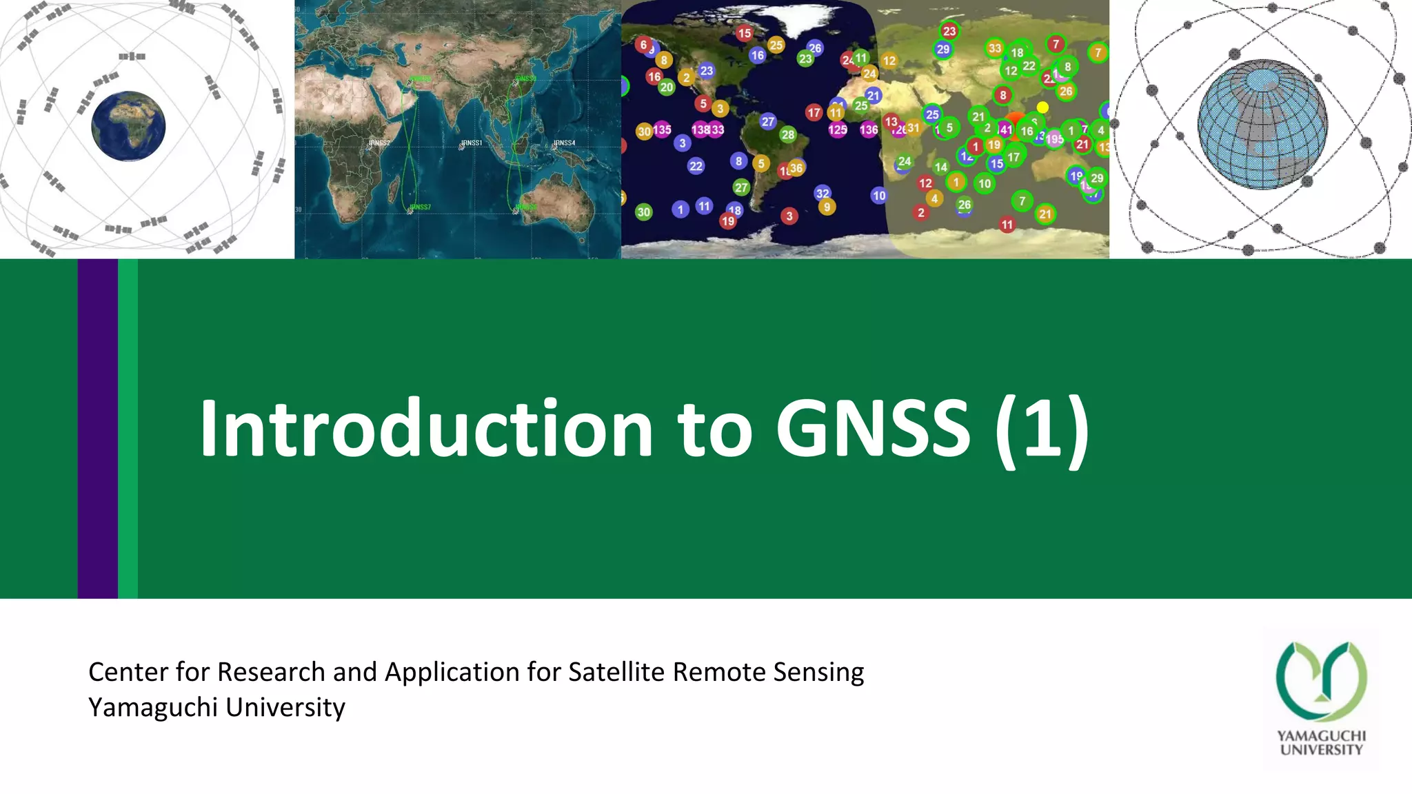
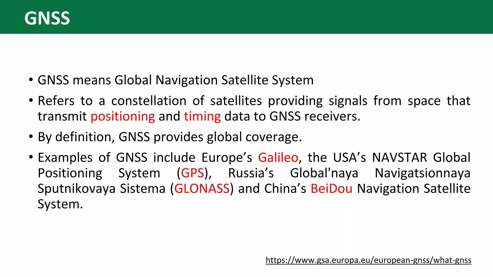
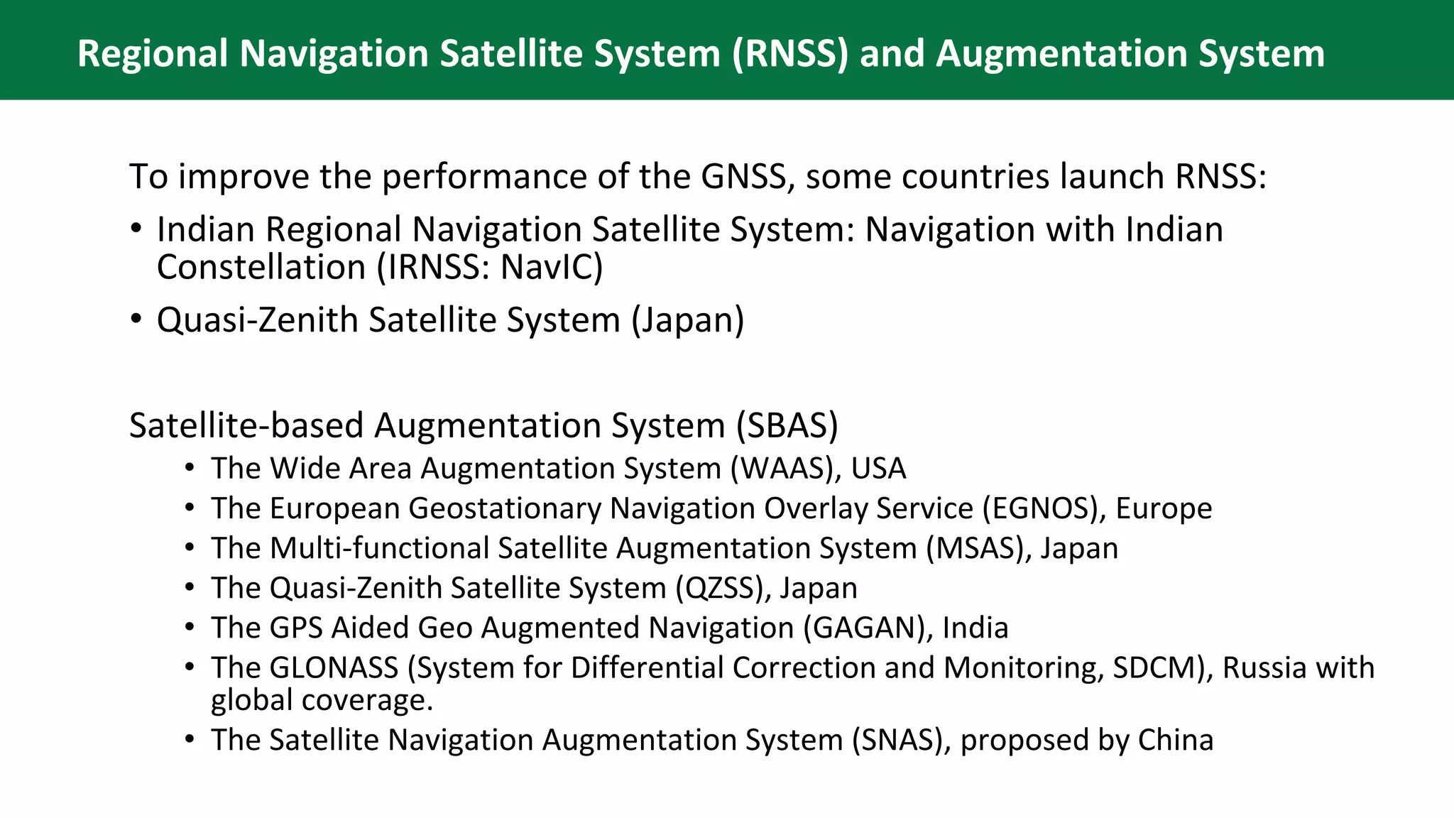
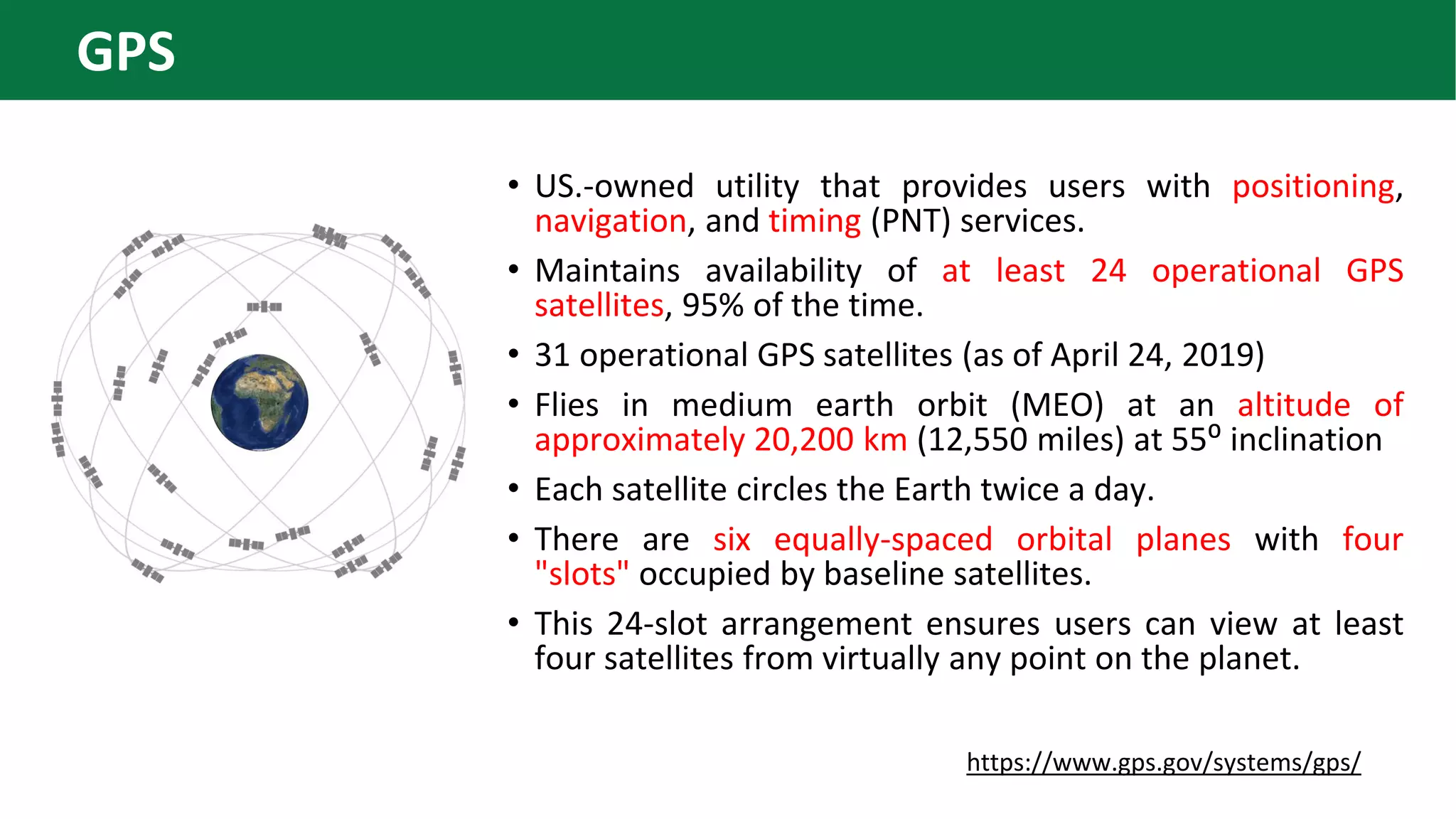
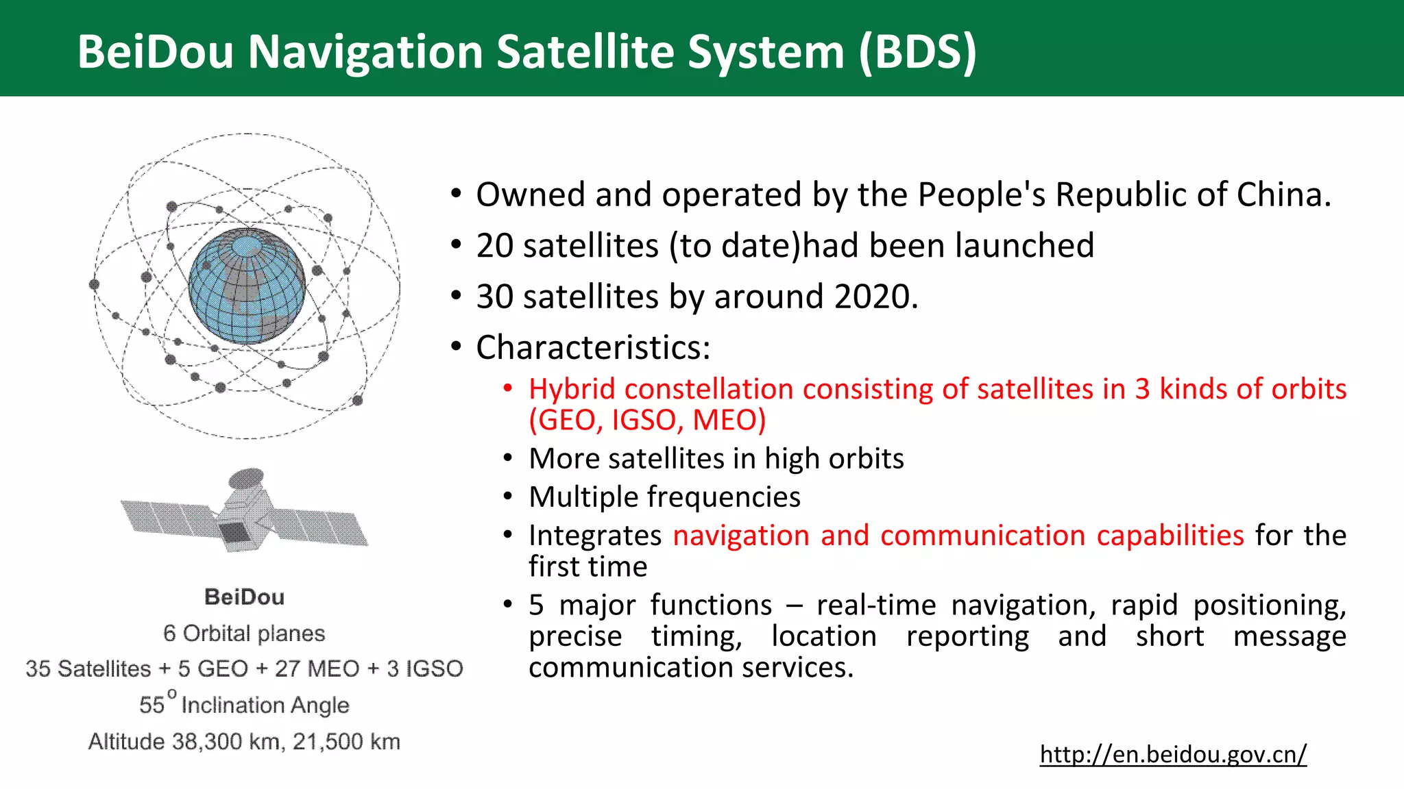
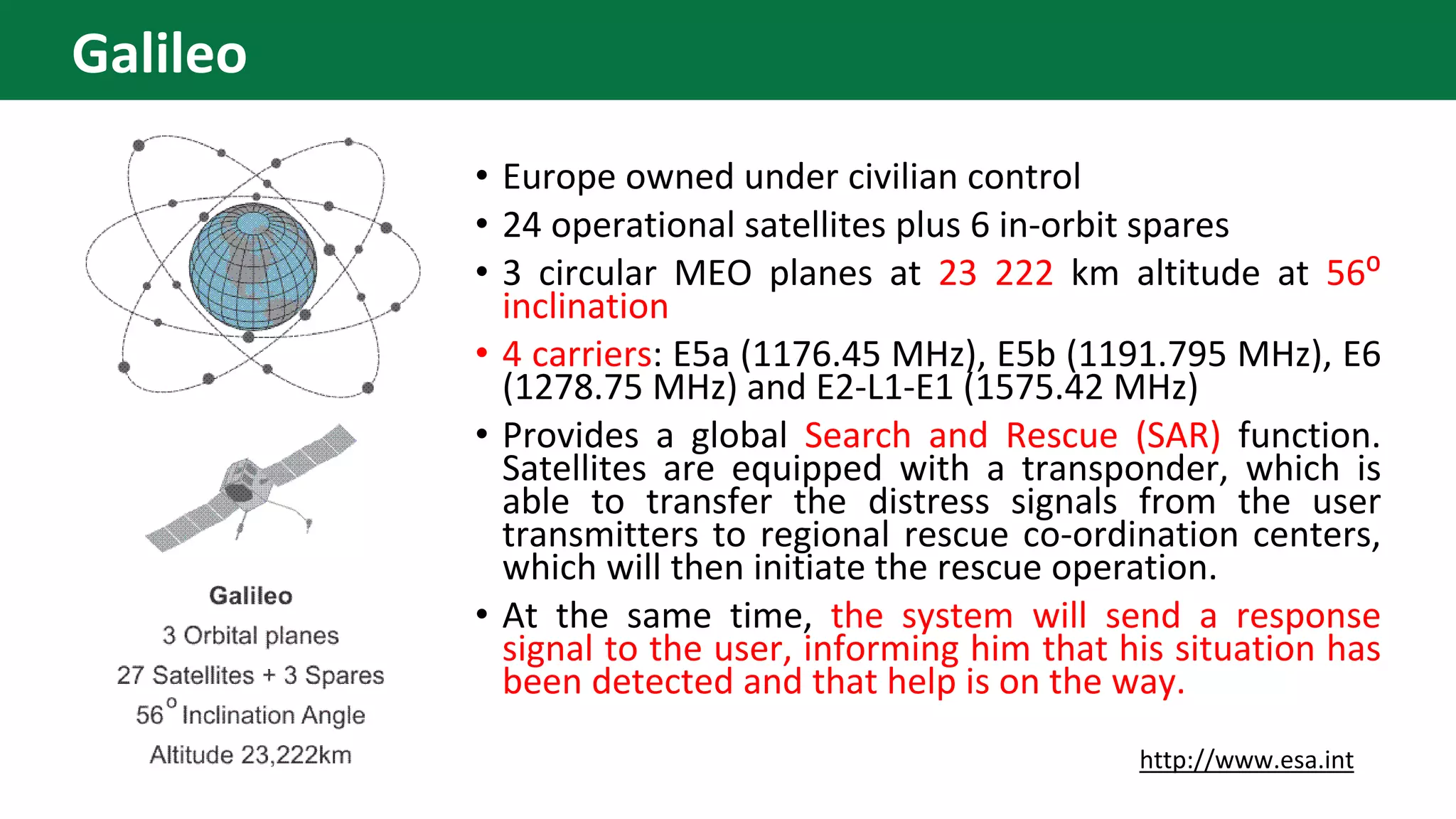
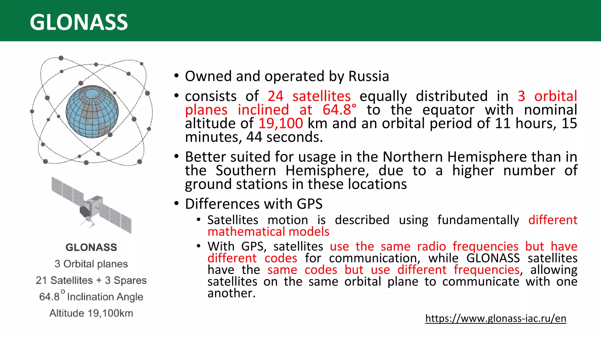
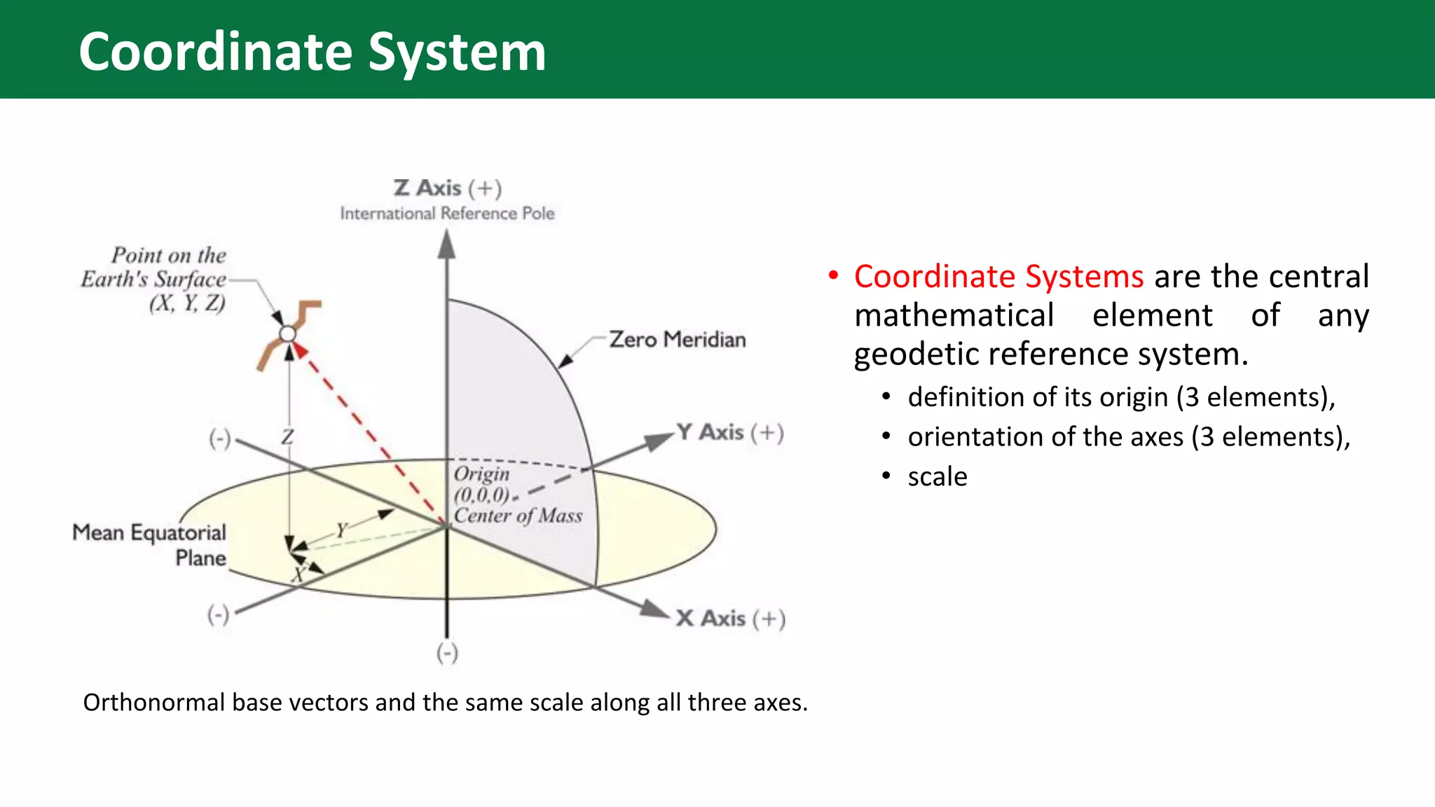
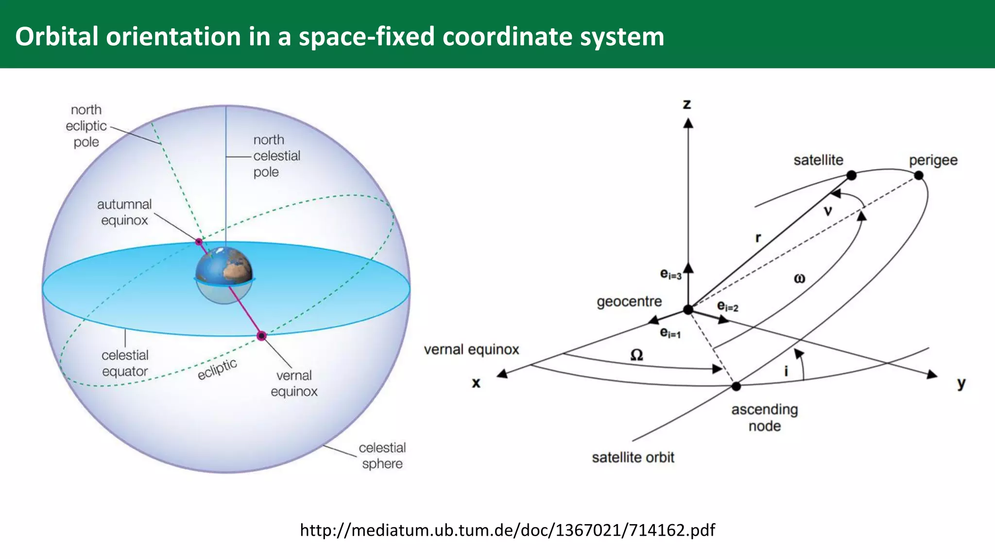
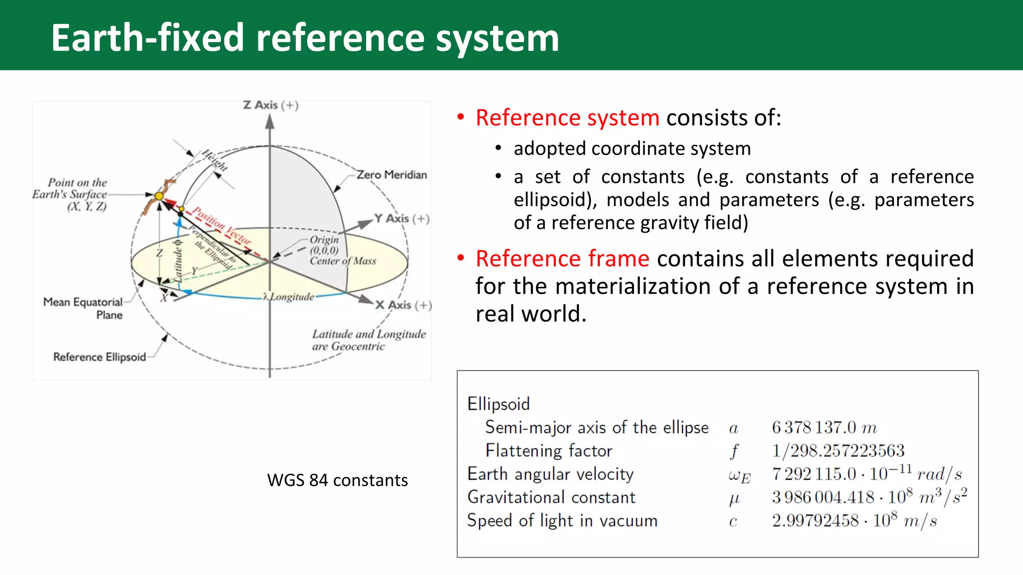
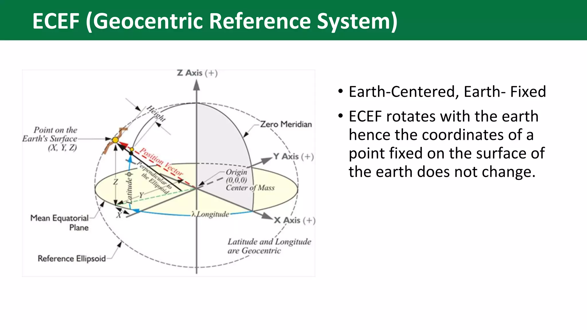
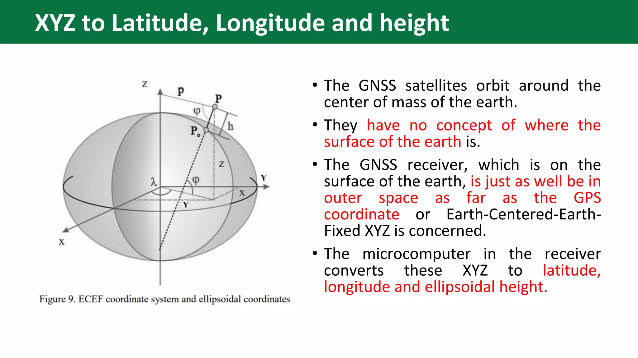
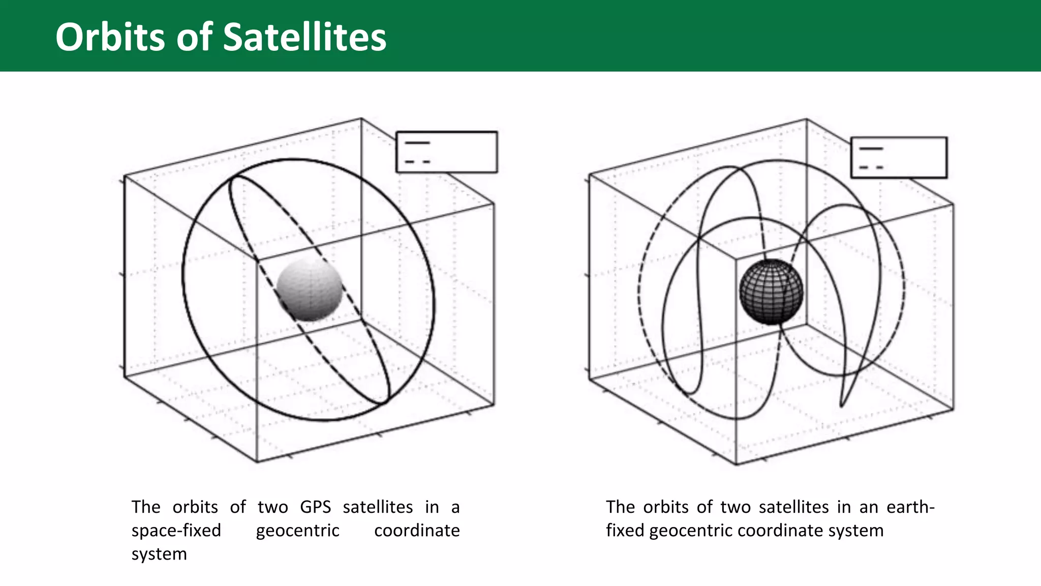
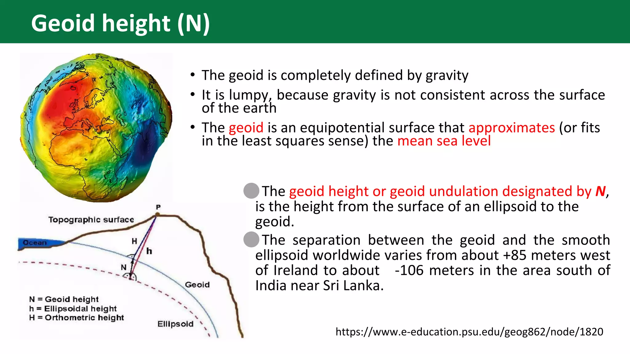
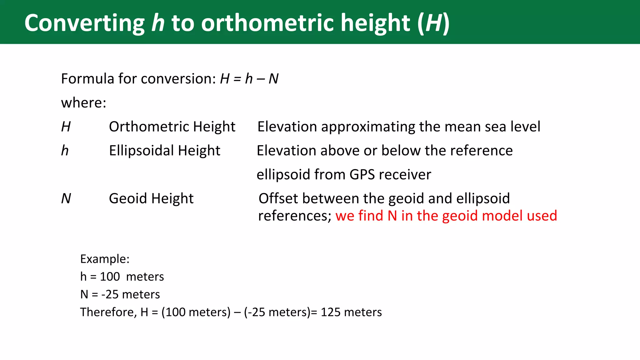
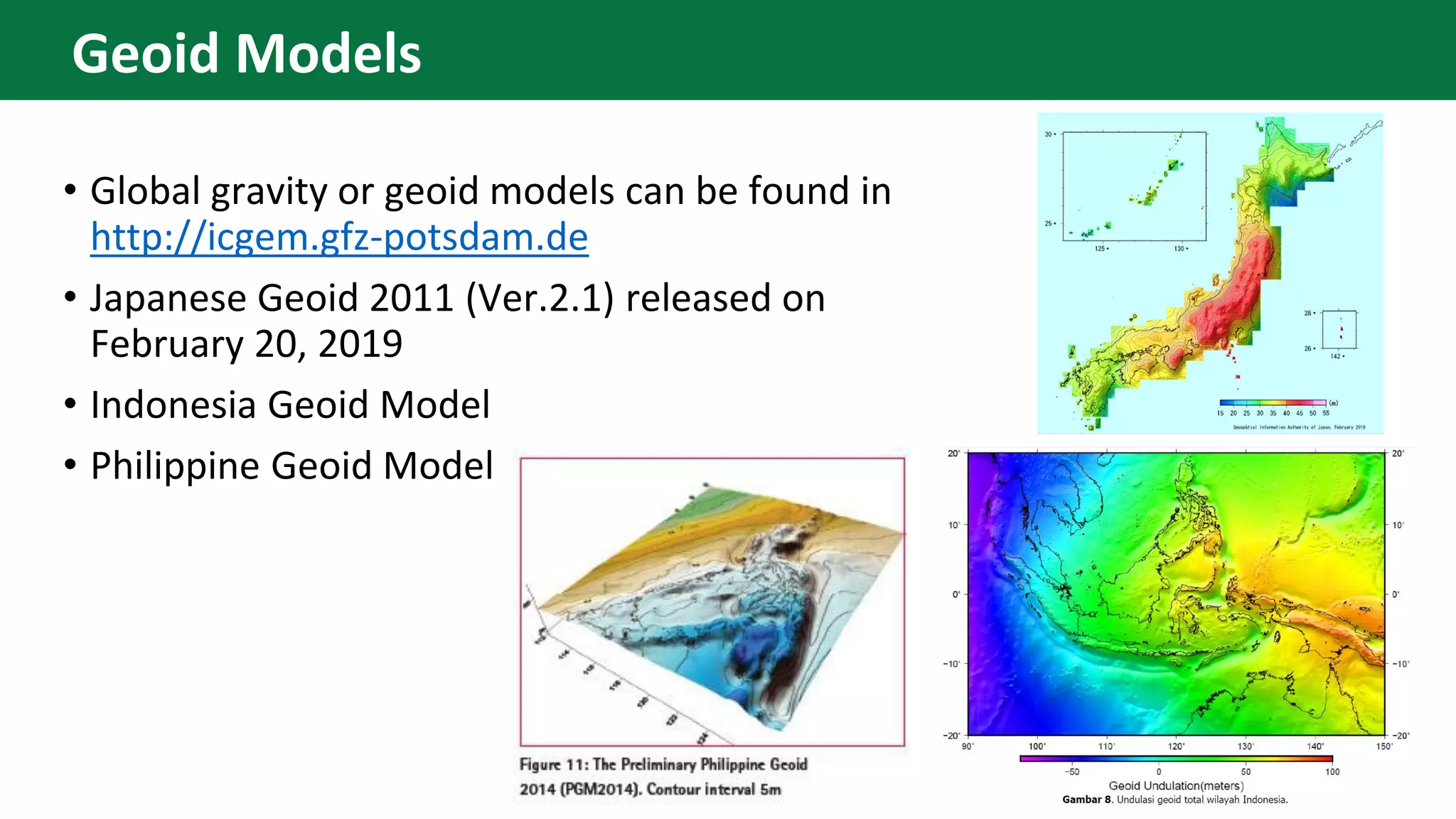
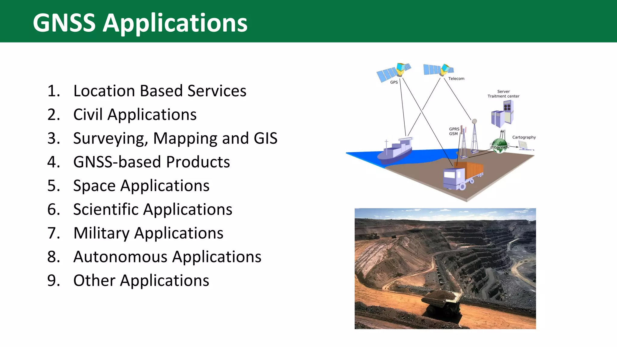
This content introduces the Global Navigation Satellite System (GNSS), its example, earth observation orbit types, coordinate systems, GNSS time system, converting height (ellipsoidal, geoid, orthometric heights) and various GNSS applications.
The Global Positioning System (GPS), originally Navstar GPS, is a satellite-based radionavigation system owned by the United States government and operated by the United States Space Force.
It is one of the global navigation satellite systems (GNSS) that provides geolocation and time information to a GPS receiver anywhere on or near the Earth where there is an unobstructed line of sight to four or more GPS satellites.
Obstacles such as mountains and buildings block the relatively weak GPS signals.
The Global Positioning System (GPS), originally Navstar GPS,[1][2] is a space-based radionavigation system owned by the United States government and operated by the United States Air Force. It is a global navigation satellite system that provides geolocation and time information to a GPS receiver anywhere on or near the Earth where there is an unobstructed line of sight to four or more GPS satellites
Group presentation done on GPS technology it covers
1.Introduction -History,Background
2.What is GPS - Technology, infrastructure
3.How GPS Works - Theory,Mathematical explanation
4.Applications of GPS
5.Drawbacks of GPS
6.Future Development
#References are added to the note section of the slides.
Brilliant Lecture delivered to me in Alagappa Engineering college Workshop.
The Global Positioning System (GPS) is a satellite
based radio navigation system provided by the
United States Department of Defence. It gives
unequaled accuracy and flexibility in positioning
for navigation, surveying and GIS data collection.
This notes helps one to acquire noteable knowledege in the field of satellite geodesy. It also includes the moevement of satellites in orbit, how they communicate with people on earth. This satellites communicate using GPS receivers which are placed on earth. Waves are sent and these waces contain data.
Application of OpenStreetMap in Disaster Risk ManagementNopphawanTamkuan
This content presents the four procedures were investigated in detail with an emphasis on simplicity for application to disaster management (download from OSM website, download using QGIS plugin, download a file converted to a universal file format (shapefile) and adding rendered map in the background). The use of these data for resilient urban planning are demonstrated including setting a hazard layer (flood Model), setting an exposure layer (population) and exposure analysis using InaSAFE plugin.
This content presents a guide to access satellite (Landsat-8) and microsatellite (Diwata), and how to use gdal and AROSIC (Python-based open-source software) for co-registration.
This content describes Call Detail Records (CDR) data format, data acquisition method, visualize in Mobmap and the applications for disaster management.
Disaster Damage Assessment and Recovery Monitoring Using Night-Time Light on GEENopphawanTamkuan
This content shows the possibility and useful cases of night-time light data to assess disaster damages and recovery in post-disaster situations such as Hokkaido earthquake, dam eruption in Laos and Kerala flood in India. Moreover, how to browse and profiling night-time light on GEE are demonstrated here.
This content presents for basic of Synthetic Aperture Radar (SAR) including its geometry, how the image is created, essential parameters, interpretation, SAR sensor specification, and advantages and disadvantages.
Differential SAR Interferometry Using Sentinel-1 Data for Kumamoto EarthquakeNopphawanTamkuan
This content presents step by step of Differential SAR Interferometry or DInSAR analysis in SNAP. The case study is Kumamoto Earthquake using Sentinel-1.
Earthquake Damage Detection Using SAR Interferometric CoherenceNopphawanTamkuan
This content presents how to apply interferometric analysis for damage detection. The case study is the Kumamoto earthquake in 2016. ALOS-2 images are used to calculate interferometric coherence, and estimate coherence change of images between before- and during earthquake to estimate possible degree of damage areas.
How to better understand SAR, interpret SAR products and realize the limitationsNopphawanTamkuan
This content shows how to better understand SAR (how to interpret SAR images and read SAR interferogram ). Moreover, capacities and limitations of SAR are discussed for each disaster emergency mapping (Flood, Landslide and Earthquake).
This content presents how to detect water or flood areas using ALOS-2 images before and during floods. First, it shows how to calibrate intensity to dB, find threshold value and apply to images.
Differential SAR Interferometry Using ALOS-2 Data for Nepal EarthquakeNopphawanTamkuan
This content presents Differential SAR Interferometry or DInSAR analysis with GMTSAR (on Linux based OS, download DEM, prepare directories for processing). The case study is Nepal earthquake in 2015 using ALOS-2.
This content shows geospatial data sources for Japan and global data, coordinate reference system, and create a map of population density (Vector analysis: dissolve vector, join table, calculate area and population density.
Raster Analysis (Color Composite and Remote Sensing Indices)NopphawanTamkuan
This content shows how to download data from USGS explorer, color composition for Landsat-8 and Sentinel-2, extract specific area, and remote sensing indices (NDVI and NDWI) using raster calculator.
This content presents how to classify satellite image by QGIS Semi-automatic classification plugin. It includes pre-processing, create a region of interest (AOI), and applying classification methods.
The French Revolution, which began in 1789, was a period of radical social and political upheaval in France. It marked the decline of absolute monarchies, the rise of secular and democratic republics, and the eventual rise of Napoleon Bonaparte. This revolutionary period is crucial in understanding the transition from feudalism to modernity in Europe.
For more information, visit-www.vavaclasses.com
This is a presentation by Dada Robert in a Your Skill Boost masterclass organised by the Excellence Foundation for South Sudan (EFSS) on Saturday, the 25th and Sunday, the 26th of May 2024.
He discussed the concept of quality improvement, emphasizing its applicability to various aspects of life, including personal, project, and program improvements. He defined quality as doing the right thing at the right time in the right way to achieve the best possible results and discussed the concept of the "gap" between what we know and what we do, and how this gap represents the areas we need to improve. He explained the scientific approach to quality improvement, which involves systematic performance analysis, testing and learning, and implementing change ideas. He also highlighted the importance of client focus and a team approach to quality improvement.
The Roman Empire A Historical Colossus.pdfkaushalkr1407
The Roman Empire, a vast and enduring power, stands as one of history's most remarkable civilizations, leaving an indelible imprint on the world. It emerged from the Roman Republic, transitioning into an imperial powerhouse under the leadership of Augustus Caesar in 27 BCE. This transformation marked the beginning of an era defined by unprecedented territorial expansion, architectural marvels, and profound cultural influence.
The empire's roots lie in the city of Rome, founded, according to legend, by Romulus in 753 BCE. Over centuries, Rome evolved from a small settlement to a formidable republic, characterized by a complex political system with elected officials and checks on power. However, internal strife, class conflicts, and military ambitions paved the way for the end of the Republic. Julius Caesar’s dictatorship and subsequent assassination in 44 BCE created a power vacuum, leading to a civil war. Octavian, later Augustus, emerged victorious, heralding the Roman Empire’s birth.
Under Augustus, the empire experienced the Pax Romana, a 200-year period of relative peace and stability. Augustus reformed the military, established efficient administrative systems, and initiated grand construction projects. The empire's borders expanded, encompassing territories from Britain to Egypt and from Spain to the Euphrates. Roman legions, renowned for their discipline and engineering prowess, secured and maintained these vast territories, building roads, fortifications, and cities that facilitated control and integration.
The Roman Empire’s society was hierarchical, with a rigid class system. At the top were the patricians, wealthy elites who held significant political power. Below them were the plebeians, free citizens with limited political influence, and the vast numbers of slaves who formed the backbone of the economy. The family unit was central, governed by the paterfamilias, the male head who held absolute authority.
Culturally, the Romans were eclectic, absorbing and adapting elements from the civilizations they encountered, particularly the Greeks. Roman art, literature, and philosophy reflected this synthesis, creating a rich cultural tapestry. Latin, the Roman language, became the lingua franca of the Western world, influencing numerous modern languages.
Roman architecture and engineering achievements were monumental. They perfected the arch, vault, and dome, constructing enduring structures like the Colosseum, Pantheon, and aqueducts. These engineering marvels not only showcased Roman ingenuity but also served practical purposes, from public entertainment to water supply.
The Indian economy is classified into different sectors to simplify the analysis and understanding of economic activities. For Class 10, it's essential to grasp the sectors of the Indian economy, understand their characteristics, and recognize their importance. This guide will provide detailed notes on the Sectors of the Indian Economy Class 10, using specific long-tail keywords to enhance comprehension.
For more information, visit-www.vavaclasses.com
The Art Pastor's Guide to Sabbath | Steve ThomasonSteve Thomason
What is the purpose of the Sabbath Law in the Torah. It is interesting to compare how the context of the law shifts from Exodus to Deuteronomy. Who gets to rest, and why?
1. Center for Research and Application for Satellite Remote Sensing
Yamaguchi University
Introduction to GNSS (1)
2. • GNSS means Global Navigation Satellite System
• Refers to a constellation of satellites providing signals from space that
transmit positioning and timing data to GNSS receivers.
• By definition, GNSS provides global coverage.
• Examples of GNSS include Europe’s Galileo, the USA’s NAVSTAR Global
Positioning System (GPS), Russia’s Global'naya Navigatsionnaya
Sputnikovaya Sistema (GLONASS) and China’s BeiDou Navigation Satellite
System.
https://www.gsa.europa.eu/european-gnss/what-gnss
GNSS
3. To improve the performance of the GNSS, some countries launch RNSS:
• Indian Regional Navigation Satellite System: Navigation with Indian
Constellation (IRNSS: NavIC)
• Quasi-Zenith Satellite System (Japan)
Satellite-based Augmentation System (SBAS)
• The Wide Area Augmentation System (WAAS), USA
• The European Geostationary Navigation Overlay Service (EGNOS), Europe
• The Multi-functional Satellite Augmentation System (MSAS), Japan
• The Quasi-Zenith Satellite System (QZSS), Japan
• The GPS Aided Geo Augmented Navigation (GAGAN), India
• The GLONASS (System for Differential Correction and Monitoring, SDCM), Russia with
global coverage.
• The Satellite Navigation Augmentation System (SNAS), proposed by China
Regional Navigation Satellite System (RNSS) and Augmentation System
4. • US.-owned utility that provides users with positioning,
navigation, and timing (PNT) services.
• Maintains availability of at least 24 operational GPS
satellites, 95% of the time.
• 31 operational GPS satellites (as of April 24, 2019)
• Flies in medium earth orbit (MEO) at an altitude of
approximately 20,200 km (12,550 miles) at 55⁰ inclination
• Each satellite circles the Earth twice a day.
• There are six equally-spaced orbital planes with four
"slots" occupied by baseline satellites.
• This 24-slot arrangement ensures users can view at least
four satellites from virtually any point on the planet.
https://www.gps.gov/systems/gps/
GPS
5. • Owned and operated by the People's Republic of China.
• 20 satellites (to date)had been launched
• 30 satellites by around 2020.
• Characteristics:
• Hybrid constellation consisting of satellites in 3 kinds of orbits
(GEO, IGSO, MEO)
• More satellites in high orbits
• Multiple frequencies
• Integrates navigation and communication capabilities for the
first time
• 5 major functions – real-time navigation, rapid positioning,
precise timing, location reporting and short message
communication services.
http://en.beidou.gov.cn/
BeiDou Navigation Satellite System (BDS)
6. • Europe owned under civilian control
• 24 operational satellites plus 6 in-orbit spares
• 3 circular MEO planes at 23 222 km altitude at 56⁰
inclination
• 4 carriers: E5a (1176.45 MHz), E5b (1191.795 MHz), E6
(1278.75 MHz) and E2-L1-E1 (1575.42 MHz)
• Provides a global Search and Rescue (SAR) function.
Satellites are equipped with a transponder, which is
able to transfer the distress signals from the user
transmitters to regional rescue co-ordination centers,
which will then initiate the rescue operation.
• At the same time, the system will send a response
signal to the user, informing him that his situation has
been detected and that help is on the way.
http://www.esa.int
Galileo
7. • Owned and operated by Russia
• consists of 24 satellites equally distributed in 3 orbital
planes inclined at 64.8° to the equator with nominal
altitude of 19,100 km and an orbital period of 11 hours, 15
minutes, 44 seconds.
• Better suited for usage in the Northern Hemisphere than in
the Southern Hemisphere, due to a higher number of
ground stations in these locations
• Differences with GPS
• Satellites motion is described using fundamentally different
mathematical models
• With GPS, satellites use the same radio frequencies but have
different codes for communication, while GLONASS satellites
have the same codes but use different frequencies, allowing
satellites on the same orbital plane to communicate with one
another.
https://www.glonass-iac.ru/en
GLONASS
8. • Independent regional navigation satellite system being developed by India.
• Primary service: India and 1500 km from its boundary.
• Extended Service Area: Lat: 30⁰ S - 50 deg ⁰ N, Lon: 30⁰ - 130⁰ E
• 8 satellites – 3 GEO and 5 geosynchronous orbits inclined at 29⁰ from the
equator in 2 different planes.
IRNSS:NaVIC
9. • QZSS is a regional system owned by
the Government of Japan and
operated by QZS System Service Inc.
(QSS).
• Composed mainly of satellites in
quasi-zenith orbits (QZO)
• QZSS complements GPS to improve
coverage in East Asia and Oceania.
• To have an operational constellation
of 4 satellites by 2018 and expand it
to 7 satellites for autonomous
capability by 2023.
QZSS
10. • The International Telecommunications Union (ITU) between 1559
MHz and 1610 MHz and designated as Radio Navigation Satellite
Service (space-to-earth) (RNSS s-e).
• GPS signals between 1560 MHz and 1590 MHz.
• This same spectrum is also shared by other Global Navigation Satellite
System (GNSS) service providers and their space-based augmentation
services.
• The Russian GLONASS operates in the upper end of the RNSS band
between 1590 MHz and 1610 MHz.
Allocated bands required to operate
12. • Space segment – consists of
satellite constellations
• Control segment - consists of a
global network of ground facilities
that track the satellites, monitor
their transmissions, perform
analyses, and send commands and
data to the constellation
• User segment – includes the
equipment and the persons who
receive the signals
Segments
16. • High Earth Orbit (HEO) ≥ 35, 780 km
• Medium Earth Orbit (MEO) 2,000 to 35,780 km
• Low Earth Orbit (LEO) 180-2,000 km
https://earthobservatory.nasa.gov/features/OrbitsCatalog
Orbits
17. Inclination is the angle of the
orbit in relation to Earth’s
equator. A satellite that
orbits directly above the
equator has zero inclination.
If a satellite orbits from the
north pole (geographic, not
magnetic) to the south pole,
its inclination is 90 degrees.
Inclined orbit
18. Geosynchronous – its orbit matches Earth’s rotation. The satellite seems to stay in
place over a single longitude, though it may drift north to south (orbit may be inclined
e.g. Inclined Geosynchronous Orbit, IGSO)
Geostationary – a geosynchronous orbit where the satellite is directly over the equator
(eccentricity and inclination at zero).
Satellites are placed in HEO to match Earth’s orbit
HEO
19. • Satellites in a medium Earth orbit move more quickly.
• 2 medium Earth orbits: 1) semi-synchronous orbit
and 2) Molniya orbit.
• Semi-synchronous orbit:
• near-circular orbit (low eccentricity) about 20,200
kilometers above the earth’s surface.
• takes 12 hours to complete an orbit. In 24-hours, the
satellite crosses over the same two spots on the equator
every day.
• consistent and highly predictable.
• orbit used by many navigation satellites
• Molniya orbit:
• invented by the Russians
• works well for observing high latitudes
The Molniya orbit combines
high inclination (63.4°) with
high eccentricity (0.722) to
maximize viewing time over
high latitudes. Each orbit lasts
12 hours, so the slow, high-
altitude portion of the orbit
repeats over the same location
every day and night.
MEO
20. • Most scientific satellites and
many weather satellites are in a
nearly circular, low Earth orbit.
A Sun-synchronous orbit crosses over the equator at approximately the
same local time each day (and night). This orbit allows consistent scientific
observations with the angle between the Sun and the Earth’s surface
remaining relatively constant.
LEO
21. • Coordinate Systems are the central
mathematical element of any
geodetic reference system.
• definition of its origin (3 elements),
• orientation of the axes (3 elements),
• scale
Orthonormal base vectors and the same scale along all three axes.
Coordinate System
22. • Space-fixed or inertial systems, in which the positions of stars are
fixed or almost fixed and in which the motion of artificial satellites
can be formulated according to the Newtonian laws of mechanics.
• Earth-fixed systems, in which all terrestrial points can be expressed
conveniently as well as vehicles in motion on the earth's surface.
• Local horizon systems, fixed to observatories or instruments and
often oriented horizontally with one axis pointing towards north.
3 levels of coordinate systems
24. • Reference system consists of:
• adopted coordinate system
• a set of constants (e.g. constants of a reference
ellipsoid), models and parameters (e.g. parameters
of a reference gravity field)
• Reference frame contains all elements required
for the materialization of a reference system in
real world.
WGS 84 constants
Earth-fixed reference system
25. • Earth-Centered, Earth- Fixed
• ECEF rotates with the earth
hence the coordinates of a
point fixed on the surface of
the earth does not change.
ECEF (Geocentric Reference System)
26. • The GNSS satellites orbit around the
center of mass of the earth.
• They have no concept of where the
surface of the earth is.
• The GNSS receiver, which is on the
surface of the earth, is just as well be in
outer space as far as the GPS
coordinate or Earth-Centered-Earth-
Fixed XYZ is concerned.
• The microcomputer in the receiver
converts these XYZ to latitude,
longitude and ellipsoidal height.
XYZ to Latitude, Longitude and height
27. The orbits of two GPS satellites in a
space-fixed geocentric coordinate
system
The orbits of two satellites in an earth-
fixed geocentric coordinate system
Orbits of Satellites
29. • “Parametry Zemli 1990”(PZ-90.11) - reference system for geodetic support
of orbital missions and navigation of the Government of Russia. Needs
transformation parameters to align with WGS 84/ITRS.
• International Terrestrial Reference System (ITRS) - maintained by the
International Earth Rotation Service (IERS), which monitors the Earth's
orientation parameters for the scientific community through a global
network of observing stations.
• World Geodetic System of 1984 (WGS 84) - reference system for the Global
Positioning System (GPS). It is compatible with the International Terrestrial
Reference System (ITRS)
• Galileo Terrestrial Reference Frame (GTRF) - an independent realization of
the international terrestrial reference system (ITRS).
GNSS Geocentric Reference Systems
30. Satellite gravimetry
(measurement of gravity) Satellite Altimetry
(measurement of global
sea level)
Very Long baseline interferometry (VLBI)
(high precision and long term stability)
Satellite Laser Ranging
(SLR) (long term stability
and geo-centricity)
Lunar laser ranging (LLR) (geo-centricity,
long term stability, relativistic effects)
The French tracking system DORIS (Doppler
Ortbitography and Radiopositioning
Integrated by Satellite)
The Global Navigation Satellite System
Space techniques that are contributing to the determination of reference
system
31. • TIME is the most important element in GNSS
• Coordinated Universal Time (UTC) is the basis for civil
time today. This 24-hour time standard is kept using
highly precise atomic clocks combined with the Earth's
rotation.
• 2 components are used to determine UTC
• International Atomic Time (TAI): A time scale that combines the
output of some 200 highly precise atomic clocks worldwide and
provides the exact speed for our clocks to tick.
• Universal Time (UT1), also known as Astronomical Time, refers
to the Earth's rotation around its own axis, which determines
the length of a day.
• The International System of Units (SI) defines one second
as the time it takes a Cesium-133 atom at the ground
state to oscillate exactly 9,192,631,770 times.
https://www.timeanddate.com/time/leapseconds.html
Time System
32. • Leap seconds are added to (UTC) – and clocks worldwide
• The reason is that the velocity of Earth's rotation around its own axis
does not match the speed of atomic time.
• Atomic clocks deviate only 1 second in up to 100 million years.
• Atomic clock is more precise than Earth
Leap Second
33. • GPS Time (GPST) GPS Time
• is a continuous time scale (no leap seconds)
• starts at 0h UTC of January 6, 1980
• At that epoch, TAI was ahead by 19 seconds.
• GPS time is synchronised with the UTC (USNO) at 1 microsecond level (modulo
one second), but actually is kept within 25 ns
• TOW (Time of Week)-GPS week 0 (zero) began at the 0h UTC of January
6, 1980
• SOW (Seconds of Week) starting at 0h of Sunday
• Week roll over on August 1, 1999 and April 6, 2019 (10-bit binary limits
week number to 1024 weeks)
https://gssc.esa.int/navipedia/index.php/Time_References_in_GNSS
GNSS Time Systems
34. •GLONASS Time (GLONASST)
• generated by the GLONASS Central Synchroniser
• and the difference between the UTC (SU)GLONASST
should not exceed 1 millisecond plus three hours (i.e.,
GLONASST=UTC(SU)+3h−τ , where |τ|<1milisec.), but τ is
typically better than 1 microsecond.
• Note: Unlike GPS, Galileo or BeiDou, GLONASS time scale
implements leap seconds, like UTC
GNSS Time Systems
35. • Galileo System Time (GST)
• a continuous time scale maintained by the
Galileo Central Segment and synchronised with
TAI with a nominal offset below 50 ns.
• The GST start epoch is 0h UTC on Sunday, 22
August 1999.
• BeiDou Time (BDT)
• a continuous time scale starting at 0h UTC on
January 1, 2006 and is synchronised with UTC
within 100 ns< (modulo one second)
Atomic clock on board Galileo satellite
GNSS Time Systems
36. • Why is geoid important in GNSS positioning?
“The earth is not a perfect ellipsoid. It has mountains, craters, and other
features above or below the mathematically perfect ellipsoidal reference.
That’s why you could take a GPS receiver on a boating dock at “sea level” and
capture a — perfectly accurate — ellipsoidal height of -20 meters. But a dock
isn’t 20 meters under water (or you would have bigger issues than interpreting
your GPS receiver). So, although your GPS receiver’s ellipsoidal reading is
accurate, it doesn’t seem to make sense”.
-https://eos-gnss.com/elevation-for-beginners
• Therefore, users must transform their ellipsoidal height into a practical
elevation reference.
The Geoid (Earth Gravity Model)
37. • A reference ellipsoid may be above or below
the surface of the earth
• If the ellipsoid’s surface is below the surface
of the earth, h is positive;
• if the ellipsoid’s surface is above the surface
of the earth at the point, h is negative (e.g.
Dead Sea Region and parts of Canada)
Ellipsoidal height (h)
38. • The geoid is completely defined by gravity
• It is lumpy, because gravity is not consistent across the surface
of the earth
• The geoid is an equipotential surface that approximates (or fits
in the least squares sense) the mean sea level
⚫The geoid height or geoid undulation designated by N,
is the height from the surface of an ellipsoid to the
geoid.
⚫The separation between the geoid and the smooth
ellipsoid worldwide varies from about +85 meters west
of Ireland to about -106 meters in the area south of
India near Sri Lanka.
https://www.e-education.psu.edu/geog862/node/1820
Geoid height (N)
39. Formula for conversion: H = h – N
where:
H Orthometric Height Elevation approximating the mean sea level
h Ellipsoidal Height Elevation above or below the reference
ellipsoid from GPS receiver
N Geoid Height Offset between the geoid and ellipsoid
references; we find N in the geoid model used
Example:
h = 100 meters
N = -25 meters
Therefore, H = (100 meters) – (-25 meters)= 125 meters
Converting h to orthometric height (H)
40. • Global gravity or geoid models can be found in
http://icgem.gfz-potsdam.de
• Japanese Geoid 2011 (Ver.2.1) released on
February 20, 2019
• Indonesia Geoid Model
• Philippine Geoid Model
Geoid Models
41. 1. Location Based Services
2. Civil Applications
3. Surveying, Mapping and GIS
4. GNSS-based Products
5. Space Applications
6. Scientific Applications
7. Military Applications
8. Autonomous Applications
9. Other Applications
GNSS Applications
42. • Location based Information Streams - consists on pushing information
to the user depending on its location and on the assumption that this
information will be useful and welcomed by the user (e.g. alerts or
warnings, nearest services, location-based advertising)
• Tourist Information - provide guidance and landmark information to
tourists typically in urban environments
• Games – mostly in GNSS enabled mobile devices such as geocaching,
scavenger hunts, role playing and adventure games (e.g. catching
Pokemon)
• Carpooling and Transport on Demand - arranged rides that vary from
informal pick-points, manned booking agencies to web based booking
sites[
1. Location Based Services
43. • Personal Applications – pedestrian navigation, outdoor navigation, social
networking, photography geocoding, location-based services
• Road Applications - road navigation, tolling, emergency services, traffic
management, fleet management & vehicle tracking
• Aviation Applications - GNSS Augmentation (ABAS, GBAS and SBAS), en route
navigation, approach, attitude determination, air traffic control
• Rail Applications - train control and signaling, passenger traffic or
transportation of dangerous goods, fleet management, goods tracking and
other logistic information management
• Maritime Applications - observing the changes of sea level, dredging
operations, wrecks location, laying pipe lines, search and rescue of sinking
vessels, dynamic positioning, positioning of oil rigs and fixing of satellite sea
launch platforms, Automatic Identification System (AIS), Vessel Traffic Service
(VTS)
• Industry Applications - precision agriculture, package and container tracking,
mining
2. Civil Applications
44. • Land Surveying – GNSS provides very high accuracy positioning for
geodetic and projects control establishment
• Mapping & GIS - data capture, digital map displays, low-cost mapping
of infrastructures
• Aerial Survey - manned and unmanned aeroplanes where the sensors
(cameras, radars, lasers, detectors, etc) and the GNSS receiver are
setup and are calibrated for the adequate georeferencing of the
collected data.
3. Surveying, Mapping and GIS
45. • Personal Products - handheld outdoor receivers, sport
watches & computers, phones, personal trackers
• Road Products - Personal Navigation Devices (PND)
and vehicle trackers
• Aviation Products - flight management system (FMS),
flight decks and avionics, or glass cockpit equipped
with GNSS receiver
• Maritime Products – chartplotters that include
navigation in 3D maps, integration of other sensors
and devices, such as barometric altimeter, depth
sounder, electromagnetic compass or radar and
fishfinder location capabilities
4. GNSS-based Products
46. • Precise Orbit Determination – precise orbit
means precise positioning. Precise orbits are
calculated in post processing (usually on the
ground segment) based on the analysis of the
actual orbits of the satellite
• Satellite Realtime Navigation - navigation of
spacecraft, Automated Transfer Vehicle (ATV)
(expendable, unmanned resupply spacecraft)
• Satellite Formation Flying - relative positions
of the satellites must be maintained precisely
as they close in
5. Space Applications
47. • Earth Sciences - geodesy and
geodynamics, remote sensing using
GNSS-Reflectometry (GNSS-R); physics
of the ionosphere and troposphere.
• Space-time Metrology - comparison of
distant clocks, assessment of the
properties of (primary) frequency
standards
• Fundamental Physics - relativistic
mechanics (synchronisation of distant
clocks, relativistic effects); quantum
mechanics (quantum communication,
relativity and earth gravitational field)
6. Scientific Applications
48. • Military Navigation - forces
location, forces navigation,
forces deployment, all
weather and around the clock
operations, communication
network timing, remotely
operated vehicles, signal
jamming/anti-jamming
• Target Acquisition - target
acquisition systems, missile
precision guidance
7. Military Applications
49. • Autonomous Driving - GNSS receptor
and antenna providing position to the
car's autopilot system
• Autonomous Flying - Advanced UAVs
(Unmanned Aerial Vehicles) are used in
missions covering security, surveillance
of infrastructures, search and rescue,
mapping, fisheries, agriculture, forestry,
natural resource monitoring, fire
fighting and emergency management,
airborne communication collection and
relay, weather data collection,
environmental monitoring, pollution
detection and other scientific research
8. Autonomous Applications
50. • Precise Time Reference
• network synchronization for power generation and distribution,
• communication networks - real-time video, video conferencing, bank-to-bank
encrypted exchange
• data encryption and security - electronic encryption, signature and time-
stamping rely on highly precise time references especially in the financial sector
On GPS time: “Cell towers use it to route your phone calls, ATMs and cash registers
use it for your transactions, electrical grids use it to send power to your house, and
stock exchanges use it to regulate the trades that go into your stock portfolio or
investment fund”-Tim Fernholz
• Atmospheric Sensing – delay in the GNSS signal can be used for sensing
the upper atmosphere e.g GNSS occultation
9. Other Applications