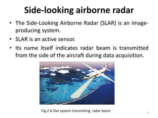
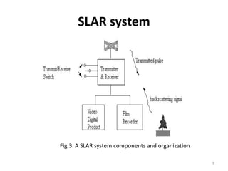
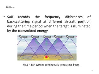
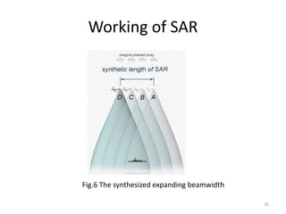
SlideShare a Scribd company logo
SIDE-LOOKING
AIRBORNE RADAR
1
Contents
• Introduction
• Remote sensing
• Types of remote sensing
• Radars
• Doppler radar
• Side looking airborne radar
• Ground resolution
• Azimutal resolution
• Synthetic aperture radar
• Working of synthetic aperture radar
• Applications
• Conclusion 2
Introduction
• The airborne radar systems that form microwave
images of adjacent terrain in fine detail, regardless of
weather or time of day or night, by looking to the
side of an aircraft.
3
Fig.1 Airborne radar in sky
Remote sensing
• Remote sensing is a technology used for obtaining
information about a target through the analysis of
data acquired from the target at a distance. It is
composed of three parts,
• The targets
• The data acquisition
• The data analysis
4
Types of Remote Sensing
• Based on Source of energy
1. Active sensors
2. Passive sensors
• Based on Range of Electromagnetic Spectrum
1. Optical Remote Sensing
2. Thermal Remote Sensing
3. Microwave Remote Sensing
5
Radars
• Radar represents "radio detection and ranging".
• A radar system transmits pulses in the direction of
interest and records the strength and origin of
reflection received from objects
• Radar systems may or may not produce images
6
Doppler radar
• Doppler radar is a specialized radar that uses
the Doppler effect to produce velocity data about
objects at a distance.
• It does this by bouncing a microwave signal off a
desired target and analyzing how the object's motion
has altered the frequency of the returned signal.
• This variation gives direct and highly accurate
measurements of the radial component of a target's
velocity relative to the radar.
7
Side-looking airborne radar
• The Side-Looking Airborne Radar (SLAR) is an image-
producing system.
• SLAR is an active sensor.
• Its name itself indicates radar beam is transmitted
from the side of the aircraft during data acquisition.
8
Fig.2 A Slar system transmiting radar beam
SLAR system
9
Fig.3 A SLAR system components and organization
Ground resolution
• There is a spatial resolution which is determined by
the duration of a pulse and the depression angle.This
resolution is called ground range resolution (rg).
• The ground resolution of slar system is determined
by two independent sensing parameters: pulse
length and antenna beam width
• We then can determine the distance or the 'slant
range' between the antenna and the target
10
11
where
Sr: the slant range.
c: the speed of light.
t: time period for a returned
transmitted pulse.
Fig.4 Sensing parameters
Cont.....
12
Fig.5 The across track spatial resolution
Cont......
Azimuth Resolution
• The along track distinguishing ability of a SLAR system
is called azimuth resolution (ra).
where
• can be the actual physical length of an antenna or a
synthetic one
13
Synthetic aperture radar
• Synthetic aperture radar (SAR) an advance version of
SLAR
• SAR is used to create images of objects, such as
landscapes – these images can be either two or three
dimensional representations of the object.
• SAR is typically mounted on a moving platform such
as an aircraft or spacecraft
• The larger the aperture is, the higher the image
resolution will be.
14
• SAR records the frequency differences of
backscattering signal at different aircraft position
during the time period when the target is illuminated
by the transmitted energy.
15
Fig.6 A SAR system continuously generating beam
Cont......
Working of SAR
16
Fig.6 The synthesized expanding beamwidth
• The SAR works similar of a phased array .
• The SAR-processor stores all the radar returned signals,
as amplitudes and phases, for the time period T from
position A to D.
• Now it is possible to reconstruct the signal which
would have been obtained by an antenna of length v ·
T, where v is the platform speed.
• As the line of sight direction changes along the radar
platform trajectory, a synthetic aperture is produced by
signal processing that has the effect of lengthening the
antenna.
• Making T large makes the „synthetic aperture” large
and hence a higher resolution can be achieved
17
Cont......
Applications
• Synthetic aperture Radar produces images of
high-resolution at great distances, that appear
to be taken from above
• Sensor Operators
• Command, Control, Intelligence training
• Research & Development
18
Conclusion
• Side looking airborne radar systems that form
microwave images of adjacent terrain in fine
detail, regardless of weather or time of day or
night, by looking to the side of an aircraft with
good resolution.
19
20
21
Any Queries

More Related Content

What's hot

Gps
GpsGps
Introduction to Landsat
Introduction to LandsatIntroduction to Landsat
Introduction to Landsat
Nizam GIS
 
Remote sensing
Remote sensingRemote sensing
Remote sensing
Kaium Chowdhury
 
Fundamentals of Remote Sensing
Fundamentals of Remote Sensing Fundamentals of Remote Sensing
Fundamentals of Remote Sensing
Pallab Jana
 
Chapter 1 (Introduction to remote sensing)
Chapter 1 (Introduction to remote sensing)Chapter 1 (Introduction to remote sensing)
Chapter 1 (Introduction to remote sensing)
Shankar Gangaju
 
Microwave remote sensing
Microwave remote sensingMicrowave remote sensing
Microwave remote sensing
Mohsin Siddique
 
Global Positioning System
Global Positioning System Global Positioning System
Global Positioning System
Himanshu Agrawal
 
Remote Sensing Platforms and Sensors
Remote Sensing Platforms and SensorsRemote Sensing Platforms and Sensors
Remote Sensing Platforms and Sensors
Uday kumar Devalla
 
Microwave remote sensing
Microwave remote sensingMicrowave remote sensing
Microwave remote sensing
Soumik Chakraborty
 
Remote sensing - Scanners
Remote sensing - ScannersRemote sensing - Scanners
Remote sensing - Scanners
Pramoda Raj
 
Application of gps
Application of gpsApplication of gps
Application of gps
Selvakumar Radhakrishnan
 
Radar remote sensing, P K MANI
Radar remote sensing, P K MANIRadar remote sensing, P K MANI
Radar remote sensing, P K MANI
P.K. Mani
 
Geometry and types of aerial photographs
Geometry and types of aerial photographsGeometry and types of aerial photographs
Geometry and types of aerial photographsPooja Kumari
 
Sensors for remote sensing
Sensors for remote sensingSensors for remote sensing
Sensors for remote sensing
Mohsin Siddique
 
. Atmospheric window and reflectance curve
. Atmospheric window and  reflectance curve. Atmospheric window and  reflectance curve
. Atmospheric window and reflectance curve
marutiChilame
 
Aerial photography.pptx
Aerial photography.pptxAerial photography.pptx
Aerial photography.pptx
Pramoda Raj
 
Principles of Remote Sensing
Principles of Remote Sensing Principles of Remote Sensing
Principles of Remote Sensing
Ariful Islam
 
Thermal remote sensing and its applications
Thermal remote sensing and its applicationsThermal remote sensing and its applications
Thermal remote sensing and its applications
chandan00781
 
Remote sensing
Remote sensingRemote sensing
Remote sensing
Mohit Goyal
 
Concept of remote sensing
Concept of remote sensingConcept of remote sensing
Concept of remote sensing
UTTAM KUMAR PARIDA
 

What's hot (20)

Gps
GpsGps
Gps
 
Introduction to Landsat
Introduction to LandsatIntroduction to Landsat
Introduction to Landsat
 
Remote sensing
Remote sensingRemote sensing
Remote sensing
 
Fundamentals of Remote Sensing
Fundamentals of Remote Sensing Fundamentals of Remote Sensing
Fundamentals of Remote Sensing
 
Chapter 1 (Introduction to remote sensing)
Chapter 1 (Introduction to remote sensing)Chapter 1 (Introduction to remote sensing)
Chapter 1 (Introduction to remote sensing)
 
Microwave remote sensing
Microwave remote sensingMicrowave remote sensing
Microwave remote sensing
 
Global Positioning System
Global Positioning System Global Positioning System
Global Positioning System
 
Remote Sensing Platforms and Sensors
Remote Sensing Platforms and SensorsRemote Sensing Platforms and Sensors
Remote Sensing Platforms and Sensors
 
Microwave remote sensing
Microwave remote sensingMicrowave remote sensing
Microwave remote sensing
 
Remote sensing - Scanners
Remote sensing - ScannersRemote sensing - Scanners
Remote sensing - Scanners
 
Application of gps
Application of gpsApplication of gps
Application of gps
 
Radar remote sensing, P K MANI
Radar remote sensing, P K MANIRadar remote sensing, P K MANI
Radar remote sensing, P K MANI
 
Geometry and types of aerial photographs
Geometry and types of aerial photographsGeometry and types of aerial photographs
Geometry and types of aerial photographs
 
Sensors for remote sensing
Sensors for remote sensingSensors for remote sensing
Sensors for remote sensing
 
. Atmospheric window and reflectance curve
. Atmospheric window and  reflectance curve. Atmospheric window and  reflectance curve
. Atmospheric window and reflectance curve
 
Aerial photography.pptx
Aerial photography.pptxAerial photography.pptx
Aerial photography.pptx
 
Principles of Remote Sensing
Principles of Remote Sensing Principles of Remote Sensing
Principles of Remote Sensing
 
Thermal remote sensing and its applications
Thermal remote sensing and its applicationsThermal remote sensing and its applications
Thermal remote sensing and its applications
 
Remote sensing
Remote sensingRemote sensing
Remote sensing
 
Concept of remote sensing
Concept of remote sensingConcept of remote sensing
Concept of remote sensing
 

Viewers also liked

The+sniper+text
The+sniper+textThe+sniper+text
The+sniper+textbarrys23
 
Airbone Radar Applications by Wg Cdr Anupam Tiwari
Airbone Radar Applications by Wg Cdr Anupam TiwariAirbone Radar Applications by Wg Cdr Anupam Tiwari
Airbone Radar Applications by Wg Cdr Anupam Tiwari
anupamtiwari1972
 
Mis keynote part 2
Mis keynote part 2Mis keynote part 2
Mis keynote part 2
Maxine Hu
 
Report Radar and Remote Sensing
Report Radar and Remote SensingReport Radar and Remote Sensing
Report Radar and Remote Sensing
Ferro Demetrio
 
Pre Seed workshop six year study 2004-2010
Pre Seed workshop  six year study 2004-2010 Pre Seed workshop  six year study 2004-2010
Pre Seed workshop six year study 2004-2010
Dmitry Tseitlin
 
Satellite Industry Report Sept 2014
Satellite Industry Report Sept 2014Satellite Industry Report Sept 2014
Satellite Industry Report Sept 2014
Dmitry Tseitlin
 
Slar side looking airbone radar
Slar side looking airbone radarSlar side looking airbone radar
Slar side looking airbone radar
fikriflux
 
Karakterisasi Letusan Merapi menggunakan Data SAR (Synthetic Aperture Radar)
Karakterisasi Letusan Merapi menggunakan Data SAR (Synthetic Aperture Radar)Karakterisasi Letusan Merapi menggunakan Data SAR (Synthetic Aperture Radar)
Karakterisasi Letusan Merapi menggunakan Data SAR (Synthetic Aperture Radar)Achmad Darul
 
Global maritime awareness ov 1 (expanded) -10 march 2013
Global maritime awareness ov 1 (expanded) -10 march 2013 Global maritime awareness ov 1 (expanded) -10 march 2013
Global maritime awareness ov 1 (expanded) -10 march 2013 ministryofpeacephilippines
 
WE3.L10.3: THE FUTURE OF SPACEBORNE SYNTHETIC APERTURE RADAR
WE3.L10.3: THE FUTURE OF SPACEBORNE SYNTHETIC APERTURE RADARWE3.L10.3: THE FUTURE OF SPACEBORNE SYNTHETIC APERTURE RADAR
WE3.L10.3: THE FUTURE OF SPACEBORNE SYNTHETIC APERTURE RADARgrssieee
 
State Satelite Industry 2015 sept
State Satelite Industry 2015 septState Satelite Industry 2015 sept
State Satelite Industry 2015 sept
Dmitry Tseitlin
 
AESA Airborne Radar Theory and Operations Technical Training Course Sampler
AESA Airborne Radar Theory and Operations Technical Training Course SamplerAESA Airborne Radar Theory and Operations Technical Training Course Sampler
AESA Airborne Radar Theory and Operations Technical Training Course Sampler
Jim Jenkins
 
PCI Geomatics Synthetic Aperture Radar Processing Capabilities
PCI Geomatics Synthetic Aperture Radar Processing CapabilitiesPCI Geomatics Synthetic Aperture Radar Processing Capabilities
PCI Geomatics Synthetic Aperture Radar Processing Capabilities
Pci Geomatics
 
Rahul Bajpai M.tech Remote sensing & GIS RSACUP
Rahul Bajpai M.tech Remote sensing & GIS RSACUPRahul Bajpai M.tech Remote sensing & GIS RSACUP
Rahul Bajpai M.tech Remote sensing & GIS RSACUP
rahul64
 
4-IGARSS_2011_v4.ppt
4-IGARSS_2011_v4.ppt4-IGARSS_2011_v4.ppt
4-IGARSS_2011_v4.pptgrssieee
 
Synthetic aperture radar (sar) 20150930
Synthetic aperture radar (sar) 20150930Synthetic aperture radar (sar) 20150930
Synthetic aperture radar (sar) 20150930
JiyaE
 
Probing the atmosphere - new radar & lidar technologies for remote sensing of...
Probing the atmosphere - new radar & lidar technologies for remote sensing of...Probing the atmosphere - new radar & lidar technologies for remote sensing of...
Probing the atmosphere - new radar & lidar technologies for remote sensing of...
CLIC Innovation Ltd
 
Synthetic aperture radar_advanced
Synthetic aperture radar_advancedSynthetic aperture radar_advanced
Synthetic aperture radar_advancedNaivedya Mishra
 
Radar 2009 a 18 synthetic aperture radar
Radar 2009 a 18 synthetic aperture radarRadar 2009 a 18 synthetic aperture radar
Radar 2009 a 18 synthetic aperture radar
Forward2025
 

Viewers also liked (20)

The+sniper+text
The+sniper+textThe+sniper+text
The+sniper+text
 
Airbone Radar Applications by Wg Cdr Anupam Tiwari
Airbone Radar Applications by Wg Cdr Anupam TiwariAirbone Radar Applications by Wg Cdr Anupam Tiwari
Airbone Radar Applications by Wg Cdr Anupam Tiwari
 
Airborne radar
Airborne  radarAirborne  radar
Airborne radar
 
Mis keynote part 2
Mis keynote part 2Mis keynote part 2
Mis keynote part 2
 
Report Radar and Remote Sensing
Report Radar and Remote SensingReport Radar and Remote Sensing
Report Radar and Remote Sensing
 
Pre Seed workshop six year study 2004-2010
Pre Seed workshop  six year study 2004-2010 Pre Seed workshop  six year study 2004-2010
Pre Seed workshop six year study 2004-2010
 
Satellite Industry Report Sept 2014
Satellite Industry Report Sept 2014Satellite Industry Report Sept 2014
Satellite Industry Report Sept 2014
 
Slar side looking airbone radar
Slar side looking airbone radarSlar side looking airbone radar
Slar side looking airbone radar
 
Karakterisasi Letusan Merapi menggunakan Data SAR (Synthetic Aperture Radar)
Karakterisasi Letusan Merapi menggunakan Data SAR (Synthetic Aperture Radar)Karakterisasi Letusan Merapi menggunakan Data SAR (Synthetic Aperture Radar)
Karakterisasi Letusan Merapi menggunakan Data SAR (Synthetic Aperture Radar)
 
Global maritime awareness ov 1 (expanded) -10 march 2013
Global maritime awareness ov 1 (expanded) -10 march 2013 Global maritime awareness ov 1 (expanded) -10 march 2013
Global maritime awareness ov 1 (expanded) -10 march 2013
 
WE3.L10.3: THE FUTURE OF SPACEBORNE SYNTHETIC APERTURE RADAR
WE3.L10.3: THE FUTURE OF SPACEBORNE SYNTHETIC APERTURE RADARWE3.L10.3: THE FUTURE OF SPACEBORNE SYNTHETIC APERTURE RADAR
WE3.L10.3: THE FUTURE OF SPACEBORNE SYNTHETIC APERTURE RADAR
 
State Satelite Industry 2015 sept
State Satelite Industry 2015 septState Satelite Industry 2015 sept
State Satelite Industry 2015 sept
 
AESA Airborne Radar Theory and Operations Technical Training Course Sampler
AESA Airborne Radar Theory and Operations Technical Training Course SamplerAESA Airborne Radar Theory and Operations Technical Training Course Sampler
AESA Airborne Radar Theory and Operations Technical Training Course Sampler
 
PCI Geomatics Synthetic Aperture Radar Processing Capabilities
PCI Geomatics Synthetic Aperture Radar Processing CapabilitiesPCI Geomatics Synthetic Aperture Radar Processing Capabilities
PCI Geomatics Synthetic Aperture Radar Processing Capabilities
 
Rahul Bajpai M.tech Remote sensing & GIS RSACUP
Rahul Bajpai M.tech Remote sensing & GIS RSACUPRahul Bajpai M.tech Remote sensing & GIS RSACUP
Rahul Bajpai M.tech Remote sensing & GIS RSACUP
 
4-IGARSS_2011_v4.ppt
4-IGARSS_2011_v4.ppt4-IGARSS_2011_v4.ppt
4-IGARSS_2011_v4.ppt
 
Synthetic aperture radar (sar) 20150930
Synthetic aperture radar (sar) 20150930Synthetic aperture radar (sar) 20150930
Synthetic aperture radar (sar) 20150930
 
Probing the atmosphere - new radar & lidar technologies for remote sensing of...
Probing the atmosphere - new radar & lidar technologies for remote sensing of...Probing the atmosphere - new radar & lidar technologies for remote sensing of...
Probing the atmosphere - new radar & lidar technologies for remote sensing of...
 
Synthetic aperture radar_advanced
Synthetic aperture radar_advancedSynthetic aperture radar_advanced
Synthetic aperture radar_advanced
 
Radar 2009 a 18 synthetic aperture radar
Radar 2009 a 18 synthetic aperture radarRadar 2009 a 18 synthetic aperture radar
Radar 2009 a 18 synthetic aperture radar
 

Similar to side-looking airborne radar

Chapter 3: Remote sensing Technology
Chapter 3: Remote sensing TechnologyChapter 3: Remote sensing Technology
Chapter 3: Remote sensing Technology
Shankar Gangaju
 
Remote Sensing Data Acquisition,Scanning/Imaging systems
Remote Sensing Data Acquisition,Scanning/Imaging systemsRemote Sensing Data Acquisition,Scanning/Imaging systems
Remote Sensing Data Acquisition,Scanning/Imaging systems
daniyal rustam
 
DOC-20190524-WA0008.ppt
DOC-20190524-WA0008.pptDOC-20190524-WA0008.ppt
DOC-20190524-WA0008.ppt
ssuser42ed4e
 
Surveying ii ajith sir class5
Surveying ii ajith sir class5Surveying ii ajith sir class5
Surveying ii ajith sir class5
SHAMJITH KM
 
Radar system
Radar systemRadar system
Radar system
Sai Teja
 
Synthetic aperture radar
Synthetic aperture radarSynthetic aperture radar
Synthetic aperture radar
Mahesh pawar
 
Prediction of range performance
Prediction of range performancePrediction of range performance
Prediction of range performance
bhupender rawat
 
Military radar and satellite switching
Military radar and satellite switchingMilitary radar and satellite switching
Military radar and satellite switching
MDKAWSARAHMEDSAGAR
 
LiDAR technology
LiDAR technology LiDAR technology
LiDAR technology
shlokdoshi
 
Radar using ultrasonic sensor and arduino.pptx
Radar using ultrasonic sensor and arduino.pptxRadar using ultrasonic sensor and arduino.pptx
Radar using ultrasonic sensor and arduino.pptx
robel38
 
Book 2 "Radar Sets“
Book 2 "Radar Sets“Book 2 "Radar Sets“
Book 2 "Radar Sets“
Timour Chaikhraziev
 
Continuing chapter rs.pptx
Continuing chapter rs.pptxContinuing chapter rs.pptx
Continuing chapter rs.pptx
ThomasHundasa1
 
Radio and Radar: Radar
Radio and Radar: Radar Radio and Radar: Radar
Radio and Radar: Radar
Jess Peters
 
Radar fundamentals
Radar fundamentalsRadar fundamentals
Radar fundamentals
Ali Sufyan
 
Unit 1 introduction to remote sensing
Unit  1 introduction to remote sensing Unit  1 introduction to remote sensing
Unit 1 introduction to remote sensing
Dhanalakshmi Dasari
 
UNjjjjjjjjjjjjjjjjjjjjjjjjjoooIT - 4.pptx
UNjjjjjjjjjjjjjjjjjjjjjjjjjoooIT - 4.pptxUNjjjjjjjjjjjjjjjjjjjjjjjjjoooIT - 4.pptx
UNjjjjjjjjjjjjjjjjjjjjjjjjjoooIT - 4.pptx
obulareddydinesh
 
Tracking Radar
Tracking RadarTracking Radar
Tracking Radar
Edwin Muriyaden Wilson
 
Altm (1)
Altm (1)Altm (1)
Lidar- light detection and ranging
Lidar- light detection and rangingLidar- light detection and ranging
Lidar- light detection and ranging
Karthick Subramaniam
 

Similar to side-looking airborne radar (20)

Chapter 3: Remote sensing Technology
Chapter 3: Remote sensing TechnologyChapter 3: Remote sensing Technology
Chapter 3: Remote sensing Technology
 
Remote Sensing Data Acquisition,Scanning/Imaging systems
Remote Sensing Data Acquisition,Scanning/Imaging systemsRemote Sensing Data Acquisition,Scanning/Imaging systems
Remote Sensing Data Acquisition,Scanning/Imaging systems
 
DOC-20190524-WA0008.ppt
DOC-20190524-WA0008.pptDOC-20190524-WA0008.ppt
DOC-20190524-WA0008.ppt
 
Surveying ii ajith sir class5
Surveying ii ajith sir class5Surveying ii ajith sir class5
Surveying ii ajith sir class5
 
Radar system
Radar systemRadar system
Radar system
 
Synthetic aperture radar
Synthetic aperture radarSynthetic aperture radar
Synthetic aperture radar
 
Prediction of range performance
Prediction of range performancePrediction of range performance
Prediction of range performance
 
Military radar and satellite switching
Military radar and satellite switchingMilitary radar and satellite switching
Military radar and satellite switching
 
LiDAR technology
LiDAR technology LiDAR technology
LiDAR technology
 
Radar using ultrasonic sensor and arduino.pptx
Radar using ultrasonic sensor and arduino.pptxRadar using ultrasonic sensor and arduino.pptx
Radar using ultrasonic sensor and arduino.pptx
 
Radar tutorial
Radar tutorialRadar tutorial
Radar tutorial
 
Book 2 "Radar Sets“
Book 2 "Radar Sets“Book 2 "Radar Sets“
Book 2 "Radar Sets“
 
Continuing chapter rs.pptx
Continuing chapter rs.pptxContinuing chapter rs.pptx
Continuing chapter rs.pptx
 
Radio and Radar: Radar
Radio and Radar: Radar Radio and Radar: Radar
Radio and Radar: Radar
 
Radar fundamentals
Radar fundamentalsRadar fundamentals
Radar fundamentals
 
Unit 1 introduction to remote sensing
Unit  1 introduction to remote sensing Unit  1 introduction to remote sensing
Unit 1 introduction to remote sensing
 
UNjjjjjjjjjjjjjjjjjjjjjjjjjoooIT - 4.pptx
UNjjjjjjjjjjjjjjjjjjjjjjjjjoooIT - 4.pptxUNjjjjjjjjjjjjjjjjjjjjjjjjjoooIT - 4.pptx
UNjjjjjjjjjjjjjjjjjjjjjjjjjoooIT - 4.pptx
 
Tracking Radar
Tracking RadarTracking Radar
Tracking Radar
 
Altm (1)
Altm (1)Altm (1)
Altm (1)
 
Lidar- light detection and ranging
Lidar- light detection and rangingLidar- light detection and ranging
Lidar- light detection and ranging
 

Recently uploaded

weather web application report.pdf
weather web application report.pdfweather web application report.pdf
weather web application report.pdf
Pratik Pawar
 
The Benefits and Techniques of Trenchless Pipe Repair.pdf
The Benefits and Techniques of Trenchless Pipe Repair.pdfThe Benefits and Techniques of Trenchless Pipe Repair.pdf
The Benefits and Techniques of Trenchless Pipe Repair.pdf
Pipe Restoration Solutions
 
Gen AI Study Jams _ For the GDSC Leads in India.pdf
Gen AI Study Jams _ For the GDSC Leads in India.pdfGen AI Study Jams _ For the GDSC Leads in India.pdf
Gen AI Study Jams _ For the GDSC Leads in India.pdf
gdsczhcet
 
road safety engineering r s e unit 3.pdf
road safety engineering  r s e unit 3.pdfroad safety engineering  r s e unit 3.pdf
road safety engineering r s e unit 3.pdf
VENKATESHvenky89705
 
Halogenation process of chemical process industries
Halogenation process of chemical process industriesHalogenation process of chemical process industries
Halogenation process of chemical process industries
MuhammadTufail242431
 
block diagram and signal flow graph representation
block diagram and signal flow graph representationblock diagram and signal flow graph representation
block diagram and signal flow graph representation
Divya Somashekar
 
Industrial Training at Shahjalal Fertilizer Company Limited (SFCL)
Industrial Training at Shahjalal Fertilizer Company Limited (SFCL)Industrial Training at Shahjalal Fertilizer Company Limited (SFCL)
Industrial Training at Shahjalal Fertilizer Company Limited (SFCL)
MdTanvirMahtab2
 
Courier management system project report.pdf
Courier management system project report.pdfCourier management system project report.pdf
Courier management system project report.pdf
Kamal Acharya
 
Sachpazis:Terzaghi Bearing Capacity Estimation in simple terms with Calculati...
Sachpazis:Terzaghi Bearing Capacity Estimation in simple terms with Calculati...Sachpazis:Terzaghi Bearing Capacity Estimation in simple terms with Calculati...
Sachpazis:Terzaghi Bearing Capacity Estimation in simple terms with Calculati...
Dr.Costas Sachpazis
 
Nuclear Power Economics and Structuring 2024
Nuclear Power Economics and Structuring 2024Nuclear Power Economics and Structuring 2024
Nuclear Power Economics and Structuring 2024
Massimo Talia
 
Student information management system project report ii.pdf
Student information management system project report ii.pdfStudent information management system project report ii.pdf
Student information management system project report ii.pdf
Kamal Acharya
 
J.Yang, ICLR 2024, MLILAB, KAIST AI.pdf
J.Yang,  ICLR 2024, MLILAB, KAIST AI.pdfJ.Yang,  ICLR 2024, MLILAB, KAIST AI.pdf
J.Yang, ICLR 2024, MLILAB, KAIST AI.pdf
MLILAB
 
Pile Foundation by Venkatesh Taduvai (Sub Geotechnical Engineering II)-conver...
Pile Foundation by Venkatesh Taduvai (Sub Geotechnical Engineering II)-conver...Pile Foundation by Venkatesh Taduvai (Sub Geotechnical Engineering II)-conver...
Pile Foundation by Venkatesh Taduvai (Sub Geotechnical Engineering II)-conver...
AJAYKUMARPUND1
 
Hybrid optimization of pumped hydro system and solar- Engr. Abdul-Azeez.pdf
Hybrid optimization of pumped hydro system and solar- Engr. Abdul-Azeez.pdfHybrid optimization of pumped hydro system and solar- Engr. Abdul-Azeez.pdf
Hybrid optimization of pumped hydro system and solar- Engr. Abdul-Azeez.pdf
fxintegritypublishin
 
MCQ Soil mechanics questions (Soil shear strength).pdf
MCQ Soil mechanics questions (Soil shear strength).pdfMCQ Soil mechanics questions (Soil shear strength).pdf
MCQ Soil mechanics questions (Soil shear strength).pdf
Osamah Alsalih
 
power quality voltage fluctuation UNIT - I.pptx
power quality voltage fluctuation UNIT - I.pptxpower quality voltage fluctuation UNIT - I.pptx
power quality voltage fluctuation UNIT - I.pptx
ViniHema
 
HYDROPOWER - Hydroelectric power generation
HYDROPOWER - Hydroelectric power generationHYDROPOWER - Hydroelectric power generation
HYDROPOWER - Hydroelectric power generation
Robbie Edward Sayers
 
Immunizing Image Classifiers Against Localized Adversary Attacks
Immunizing Image Classifiers Against Localized Adversary AttacksImmunizing Image Classifiers Against Localized Adversary Attacks
Immunizing Image Classifiers Against Localized Adversary Attacks
gerogepatton
 
在线办理(ANU毕业证书)澳洲国立大学毕业证录取通知书一模一样
在线办理(ANU毕业证书)澳洲国立大学毕业证录取通知书一模一样在线办理(ANU毕业证书)澳洲国立大学毕业证录取通知书一模一样
在线办理(ANU毕业证书)澳洲国立大学毕业证录取通知书一模一样
obonagu
 
Vaccine management system project report documentation..pdf
Vaccine management system project report documentation..pdfVaccine management system project report documentation..pdf
Vaccine management system project report documentation..pdf
Kamal Acharya
 

Recently uploaded (20)

weather web application report.pdf
weather web application report.pdfweather web application report.pdf
weather web application report.pdf
 
The Benefits and Techniques of Trenchless Pipe Repair.pdf
The Benefits and Techniques of Trenchless Pipe Repair.pdfThe Benefits and Techniques of Trenchless Pipe Repair.pdf
The Benefits and Techniques of Trenchless Pipe Repair.pdf
 
Gen AI Study Jams _ For the GDSC Leads in India.pdf
Gen AI Study Jams _ For the GDSC Leads in India.pdfGen AI Study Jams _ For the GDSC Leads in India.pdf
Gen AI Study Jams _ For the GDSC Leads in India.pdf
 
road safety engineering r s e unit 3.pdf
road safety engineering  r s e unit 3.pdfroad safety engineering  r s e unit 3.pdf
road safety engineering r s e unit 3.pdf
 
Halogenation process of chemical process industries
Halogenation process of chemical process industriesHalogenation process of chemical process industries
Halogenation process of chemical process industries
 
block diagram and signal flow graph representation
block diagram and signal flow graph representationblock diagram and signal flow graph representation
block diagram and signal flow graph representation
 
Industrial Training at Shahjalal Fertilizer Company Limited (SFCL)
Industrial Training at Shahjalal Fertilizer Company Limited (SFCL)Industrial Training at Shahjalal Fertilizer Company Limited (SFCL)
Industrial Training at Shahjalal Fertilizer Company Limited (SFCL)
 
Courier management system project report.pdf
Courier management system project report.pdfCourier management system project report.pdf
Courier management system project report.pdf
 
Sachpazis:Terzaghi Bearing Capacity Estimation in simple terms with Calculati...
Sachpazis:Terzaghi Bearing Capacity Estimation in simple terms with Calculati...Sachpazis:Terzaghi Bearing Capacity Estimation in simple terms with Calculati...
Sachpazis:Terzaghi Bearing Capacity Estimation in simple terms with Calculati...
 
Nuclear Power Economics and Structuring 2024
Nuclear Power Economics and Structuring 2024Nuclear Power Economics and Structuring 2024
Nuclear Power Economics and Structuring 2024
 
Student information management system project report ii.pdf
Student information management system project report ii.pdfStudent information management system project report ii.pdf
Student information management system project report ii.pdf
 
J.Yang, ICLR 2024, MLILAB, KAIST AI.pdf
J.Yang,  ICLR 2024, MLILAB, KAIST AI.pdfJ.Yang,  ICLR 2024, MLILAB, KAIST AI.pdf
J.Yang, ICLR 2024, MLILAB, KAIST AI.pdf
 
Pile Foundation by Venkatesh Taduvai (Sub Geotechnical Engineering II)-conver...
Pile Foundation by Venkatesh Taduvai (Sub Geotechnical Engineering II)-conver...Pile Foundation by Venkatesh Taduvai (Sub Geotechnical Engineering II)-conver...
Pile Foundation by Venkatesh Taduvai (Sub Geotechnical Engineering II)-conver...
 
Hybrid optimization of pumped hydro system and solar- Engr. Abdul-Azeez.pdf
Hybrid optimization of pumped hydro system and solar- Engr. Abdul-Azeez.pdfHybrid optimization of pumped hydro system and solar- Engr. Abdul-Azeez.pdf
Hybrid optimization of pumped hydro system and solar- Engr. Abdul-Azeez.pdf
 
MCQ Soil mechanics questions (Soil shear strength).pdf
MCQ Soil mechanics questions (Soil shear strength).pdfMCQ Soil mechanics questions (Soil shear strength).pdf
MCQ Soil mechanics questions (Soil shear strength).pdf
 
power quality voltage fluctuation UNIT - I.pptx
power quality voltage fluctuation UNIT - I.pptxpower quality voltage fluctuation UNIT - I.pptx
power quality voltage fluctuation UNIT - I.pptx
 
HYDROPOWER - Hydroelectric power generation
HYDROPOWER - Hydroelectric power generationHYDROPOWER - Hydroelectric power generation
HYDROPOWER - Hydroelectric power generation
 
Immunizing Image Classifiers Against Localized Adversary Attacks
Immunizing Image Classifiers Against Localized Adversary AttacksImmunizing Image Classifiers Against Localized Adversary Attacks
Immunizing Image Classifiers Against Localized Adversary Attacks
 
在线办理(ANU毕业证书)澳洲国立大学毕业证录取通知书一模一样
在线办理(ANU毕业证书)澳洲国立大学毕业证录取通知书一模一样在线办理(ANU毕业证书)澳洲国立大学毕业证录取通知书一模一样
在线办理(ANU毕业证书)澳洲国立大学毕业证录取通知书一模一样
 
Vaccine management system project report documentation..pdf
Vaccine management system project report documentation..pdfVaccine management system project report documentation..pdf
Vaccine management system project report documentation..pdf
 

side-looking airborne radar

  • 2. Contents • Introduction • Remote sensing • Types of remote sensing • Radars • Doppler radar • Side looking airborne radar • Ground resolution • Azimutal resolution • Synthetic aperture radar • Working of synthetic aperture radar • Applications • Conclusion 2
  • 3. Introduction • The airborne radar systems that form microwave images of adjacent terrain in fine detail, regardless of weather or time of day or night, by looking to the side of an aircraft. 3 Fig.1 Airborne radar in sky
  • 4. Remote sensing • Remote sensing is a technology used for obtaining information about a target through the analysis of data acquired from the target at a distance. It is composed of three parts, • The targets • The data acquisition • The data analysis 4
  • 5. Types of Remote Sensing • Based on Source of energy 1. Active sensors 2. Passive sensors • Based on Range of Electromagnetic Spectrum 1. Optical Remote Sensing 2. Thermal Remote Sensing 3. Microwave Remote Sensing 5
  • 6. Radars • Radar represents "radio detection and ranging". • A radar system transmits pulses in the direction of interest and records the strength and origin of reflection received from objects • Radar systems may or may not produce images 6
  • 7. Doppler radar • Doppler radar is a specialized radar that uses the Doppler effect to produce velocity data about objects at a distance. • It does this by bouncing a microwave signal off a desired target and analyzing how the object's motion has altered the frequency of the returned signal. • This variation gives direct and highly accurate measurements of the radial component of a target's velocity relative to the radar. 7
  • 8. Side-looking airborne radar • The Side-Looking Airborne Radar (SLAR) is an image- producing system. • SLAR is an active sensor. • Its name itself indicates radar beam is transmitted from the side of the aircraft during data acquisition. 8 Fig.2 A Slar system transmiting radar beam
  • 9. SLAR system 9 Fig.3 A SLAR system components and organization
  • 10. Ground resolution • There is a spatial resolution which is determined by the duration of a pulse and the depression angle.This resolution is called ground range resolution (rg). • The ground resolution of slar system is determined by two independent sensing parameters: pulse length and antenna beam width • We then can determine the distance or the 'slant range' between the antenna and the target 10
  • 11. 11 where Sr: the slant range. c: the speed of light. t: time period for a returned transmitted pulse. Fig.4 Sensing parameters Cont.....
  • 12. 12 Fig.5 The across track spatial resolution Cont......
  • 13. Azimuth Resolution • The along track distinguishing ability of a SLAR system is called azimuth resolution (ra). where • can be the actual physical length of an antenna or a synthetic one 13
  • 14. Synthetic aperture radar • Synthetic aperture radar (SAR) an advance version of SLAR • SAR is used to create images of objects, such as landscapes – these images can be either two or three dimensional representations of the object. • SAR is typically mounted on a moving platform such as an aircraft or spacecraft • The larger the aperture is, the higher the image resolution will be. 14
  • 15. • SAR records the frequency differences of backscattering signal at different aircraft position during the time period when the target is illuminated by the transmitted energy. 15 Fig.6 A SAR system continuously generating beam Cont......
  • 16. Working of SAR 16 Fig.6 The synthesized expanding beamwidth
  • 17. • The SAR works similar of a phased array . • The SAR-processor stores all the radar returned signals, as amplitudes and phases, for the time period T from position A to D. • Now it is possible to reconstruct the signal which would have been obtained by an antenna of length v · T, where v is the platform speed. • As the line of sight direction changes along the radar platform trajectory, a synthetic aperture is produced by signal processing that has the effect of lengthening the antenna. • Making T large makes the „synthetic aperture” large and hence a higher resolution can be achieved 17 Cont......
  • 18. Applications • Synthetic aperture Radar produces images of high-resolution at great distances, that appear to be taken from above • Sensor Operators • Command, Control, Intelligence training • Research & Development 18
  • 19. Conclusion • Side looking airborne radar systems that form microwave images of adjacent terrain in fine detail, regardless of weather or time of day or night, by looking to the side of an aircraft with good resolution. 19
  • 20. 20