Downloaded 242 times


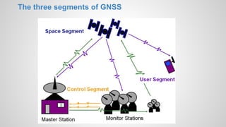


This document provides an overview of global navigation satellite systems (GNSS) such as GPS, GLONASS, Galileo, and Compass. It discusses the history and development of satellite navigation systems, comparing the key aspects of different GNSS. It also describes the typical three-segment architecture of GNSS including space, ground, and user segments. Finally, it outlines several applications of satellite-based positioning in areas like agriculture, aviation, marine, and more.


