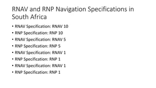
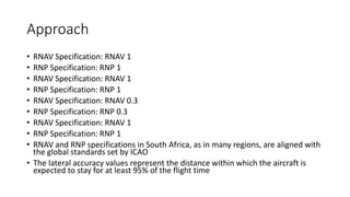
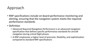
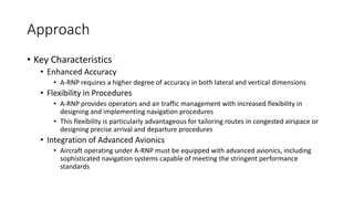
2. • The NAVSTAR Global Positioning System is a satellite navigation
system owned by the United States
• Comprising a constellation of satellites in medium Earth orbit, GPS
provides accurate positioning, velocity, and timing information
globally
• Consists of at least 24 satellites in various orbits to ensure continuous
coverage and redundancy
• Essential for en-route, terminal, and approach navigation,
contributing to precise navigation during all phases of flight
3. GLONASS
• GLONASS, or Global Navigation Satellite System, is the Russian counterpart
to GPS
• Similar to GPS, GLONASS provides global coverage, employing a
constellation of satellites in medium Earth orbit
• Offers redundancy and enhances navigation accuracy, especially in regions
where GPS signals may be compromised
• Integration of both GPS and GLONASS signals can improve navigation
accuracy and reliability for aviation applications
• Galileo is the European Union's satellite navigation system, designed to be
independent of other GNSS systems
• Aims to provide Europe with its own reliable and accurate positioning
information for various applications, including aviation
4. GLONASS
• Galileo offers a global constellation of satellites in medium Earth
orbit, enhancing navigation performance and ensuring availability
5. Beidou-2
• Beidou, also known as Compass, is China's satellite navigation system
• It consists of both regional and global components, providing
navigation services primarily in the Asia-Pacific region and expanding
globally
• The system enhances navigation accuracy, contributing to the overall
reliability of satellite navigation for aviation
6. 2. World Geodetic System 1984
• The World Geodetic System 1984 is a global reference system used for
defining positions on the Earth's surface, including the coordinates
provided by GNSS
• WGS84 is the foundation for satellite navigation systems like GPS,
GLONASS, Galileo, and Beidou
• The system consists of a reference ellipsoid, a mathematical model
approximating the Earth's shape, and a geocentric coordinate system
• GNSS receivers use WGS84 coordinates to determine an aircraft's position,
altitude, and velocity accurately
• WGS84 coordinates include latitude, longitude, and altitude
• The WGS84 datum is regularly updated to account for the Earth's dynamic
nature
7. 2. World Geodetic System 1984
• Crew members need to be aware of the importance of WGS84 in
coordinating navigation with various air traffic management systems
worldwide
• GNSS systems, when configured to WGS84, provide standardized and
interoperable navigation data, allowing for consistent and reliable air
traffic management across international airspace
8. 3. Components of the GNSS
• Satellites and Orbits
• The Space Segment is the backbone of the Global Navigation Satellite System ,
consisting of a constellation of satellites meticulously placed in medium Earth
orbit
• Typically, GNSS systems like GPS maintain a constellation of at least 24
satellites, ensuring comprehensive global coverage and redundancy
• Orbits are carefully designed to optimize coverage, allowing multiple satellites
to be visible from any point on Earth at any given time, facilitating accurate
and continuous signal reception
9. Control Segment
• Master Control Station
• The Control Segment oversees the coordination, monitoring, and control of
the entire GNSS constellation
• The MCS manages satellite orbits, adjusts timing parameters, and monitors
overall system health, guaranteeing the reliability of signals transmitted to
users
• Monitoring Stations
• Ground-based Monitoring Stations are strategically located to track and
assess signals from GNSS satellites in real-time
• These stations collect crucial data related to satellite health, signal accuracy,
and system performance
10. Control Segment
• Data Uploading Stations
• Data Uploading Stations play a pivotal role in transmitting essential updates
and corrections to satellites
• The continuous communication between Data Uploading Stations and
satellites ensures that the GNSS constellation remains finely tuned and
capable of providing accurate navigation information
11. User Segment
• GNSS Receiver
• The User Segment involves the equipment onboard aircraft and other users
that receive and process GNSS signals for navigation purposes
• GNSS Receivers decode signals from multiple satellites to determine the
user's precise position, velocity, and time
• TSO-C129 / C
• Compliance with Technical Standard Order specifications, specifically C129 and C146, is
crucial for GNSS equipment
• Displays
• Displays are integral components that provide real-time information to the flight crew
based on data derived from the GNSS receiver
• These displays offer a comprehensive view of the aircraft's position, waypoints, routes,
and other pertinent navigation details, significantly enhancing situational awareness for
the crew
12. User Segment
• GNSS Antennas
• GNSS Antennas are responsible for receiving signals from satellites and are
instrumental in determining the accuracy of position fixes
• These antennas are designed to minimize interference and optimize signal
reception, playing a critical role in ensuring the overall performance and
reliability of the GNSS system
13. GPS Satellite Signals
• The GPS satellite signals operate in the L-band, a frequency band ranging
from 1 to 2 GHz
• Specifically, the GPS signals are transmitted in two frequency bands within
the L-band: L1 and L
• L1 frequency is centered around 1575.42 MHz, and it is used for civilian purposes
• L2 frequency is centered around 1227.60 MHz and is used for both military and
civilian purposes
• The L-band frequencies were chosen for satellite navigation due to their
ability to penetrate the Earth's atmosphere with relatively low signal
attenuation, making them suitable for reliable navigation signals
• The Almanac is a set of data transmitted by each GPS satellite that provides
information about the entire GPS constellation
14. GPS Satellite Signals
• It includes the approximate orbital parameters of all satellites in the
constellation, their health status, and information about other
satellites in the network
• The Almanac is essential for GPS receivers to acquire satellite signals
efficiently
15. Ephemeris Data
• Ephemeris data provides precise information about the orbits of
individual GPS satellites
• This data includes the satellite's position in orbit, velocity, and the
time of the satellite's clock
• Ephemeris data is crucial for accurate positioning calculations by GPS
receivers
• GPS receivers download ephemeris data from satellites to make real-
time calculations, ensuring accurate positioning information for
navigation
16. How the GPS Receiver Determines Position
• To determine a three-dimensional position , a GPS receiver needs signals
from a minimum of four satellites
• With signals from four satellites, the receiver can solve for its three-
dimensional position and the clock offset
• Three satellites are sufficient for a 2D position fix , but the fourth satellite is
necessary to account for the receiver's clock error
• The GPS receiver calculates the distance to each satellite by measuring the
time it takes for the satellite's signal to travel to the receiver
• The propagation time is determined by multiplying the signal travel time by
the speed of light
• By knowing the distance to at least four satellites, the receiver can
determine its position through trilateration
17. How the GPS Receiver Determines Position
• Pseudorange is the apparent range between a GPS satellite and the
receiver, but it includes errors like clock errors and signal delays
• The GPS receiver calculates pseudoranges by measuring the time it takes
for the signal to travel from each satellite to the receiver and multiplying it
by the speed of light
• Trilateration is the mathematical technique used by the GPS receiver to
determine its position by intersecting spheres around each satellite
• Each satellite's signal provides a range or pseudorange, creating a sphere of
possible locations
• Ephemeris errors result from inaccuracies in the predicted satellite
positions transmitted by the satellites
• GPS receivers need accurate ephemeris data to calculate precise satellite
positions
18. How the GPS Receiver Determines Position
• The ionosphere can delay GPS signals, causing errors in the calculated distance
• Dual-frequency GPS receivers can mitigate ionospheric errors by using the
difference in signal delay between the L1 and L2 frequencies
• Multipath occurs when GPS signals reflect off surfaces before reaching the
receiver, causing the receiver to calculate an incorrect distance
• Tall buildings, mountains, or other reflective surfaces can lead to multipath errors
• Antenna placement and signal processing techniques are used to minimize
multipath effects
• DOP is a measure of the geometric arrangement of satellites in the sky relative to
the receiver's location
• The four main types of DOP are Position DOP , Horizontal DOP , Vertical DOP , and
Time DOP
19. How the GPS Receiver Determines Position
• Lower DOP values indicate better satellite geometry and result in
more accurate position fixes
20. How the GPS Receiver Determines Position
• WAAS is a satellite-based augmentation system developed by the Federal
Aviation Administration in the United States
• It improves the accuracy, integrity, and availability of GPS signals over a
wide geographic area, including North America
• WAAS uses a network of ground-based reference stations to monitor GPS
satellite signals and correct errors, providing enhanced accuracy for
aviation applications
• EGNOS is the SBAS designed for Europe, providing augmentation to the
GPS signals over the European region
• Similar to WAAS, EGNOS uses ground reference stations to monitor and
correct GPS signals, enhancing navigation accuracy for aviation users in
Europe
21. How the GPS Receiver Determines Position
• EGNOS improves the integrity and availability of GPS signals,
contributing to safer and more precise navigation
• RAIM is an ABAS feature that allows the GPS receiver onboard an
aircraft to autonomously monitor the integrity of the received
satellite signals
22. How the GPS Receiver Determines Position
• It detects and alerts the pilot if there is a potential issue with the GPS
signals, such as a satellite malfunction or signal interference
• Fault Detection
• FD is a part of RAIM that identifies when there is a fault in one or more satellite signals,
potentially affecting the accuracy of the navigation solution
• Fault Detection and Exclusion
• FDE goes beyond FD by not only identifying faulty satellite signals but also excluding
them from the navigation solution, ensuring the accuracy and integrity of the position
calculation
• AAIM is an advanced version of RAIM that provides additional layers
of integrity monitoring and fault detection for aviation applications
23. How the GPS Receiver Determines Position
• AAIM enhances the reliability of the GPS-based navigation solution by
continuously monitoring the integrity of the signals and taking
corrective actions in case of anomalies
• LAAS is a precision landing system that falls under the category of
GBAS
• It is designed to provide highly accurate and reliable navigation
guidance during the approach and landing phases of flight
• LAAS utilizes a network of ground-based reference stations to
augment GPS signals, allowing for precision approaches with vertical
guidance
24. 3. Describe Required Navigational
Performance
• Definition
• Required Navigational Performance is a navigation specification that defines
the minimum level of accuracy and performance required for an aircraft to
operate within a specific airspace or along a defined route
• Key Principles
• Precision Navigation
• RNP specifies the accuracy, integrity, and performance criteria necessary for an aircraft
to navigate precisely within a designated airspace or along a specific route
• Risk Management
• RNP is designed to manage navigation risks by ensuring that aircraft operating in a
particular airspace can meet the required performance standards
25. 3. Describe Required Navigational
Performance
• Components of RNP
• RNP Values
• RNP values are expressed in nautical miles and represent the lateral accuracy
requirements for the aircraft
• For example, an RNP 0.3 specification requires the aircraft to navigate within 0.3 NM of
the intended path for at least 95% of the total flight time
• Advanced Avionics
• Aircraft meeting RNP requirements are equipped with advanced avionics and navigation
systems, such as GPS or inertial navigation systems, capable of achieving the specified
performance levels
26. 3. Describe Required Navigational
Performance
• Applications of RNP
• Terminal Operations
• RNP is often applied in terminal areas, allowing for precision navigation during approach
and departure procedures
• This is particularly beneficial in busy airports where accurate navigation is crucial for safe
and efficient operations
• En-Route Navigation
• RNP specifications are also used for en-route navigation, ensuring that aircraft can
maintain the required level of accuracy while traversing specific airways or waypoints
27. 3. Describe Required Navigational
Performance
• Advantages of RNP
• Increased Precision
• RNP enhances navigation precision, allowing for more accurate and predictable aircraft
trajectories
• This precision is essential for managing airspace efficiently and minimizing conflicts between
air traffic
• Improved Safety
• By defining and adhering to specific performance standards, RNP contributes to enhanced
safety in air navigation
• The precise navigation allowed by RNP helps prevent navigation errors and reduces the risk of
mid-air collisions
• Flexibility in Procedures
• RNP specifications provide flexibility in designing and implementing navigation procedures,
contributing to optimized airspace utilization and efficient air traffic management
28. 3. Describe Required Navigational
Performance
• Example: Consider an airspace where RNP 1 specifications are in place
• Overview of Navigation Inputs to an On-board RNAV System
29. Navigation Inputs
• Ground-Based Navigation Aids
• Traditional ground-based navigation aids, such as VOR and NDB , can provide
position information to the RNAV system
• While RNAV systems are designed for navigation without relying on ground-
based aids, they may use them as additional information sources, especially
in areas with limited satellite coverage
• Ground-Based Augmentation Systems
• GBAS, such as the Local Area Augmentation System , can provide highly
accurate and precise position corrections to the RNAV system during
approach and landing phases
30. Navigation Inputs
• Inertial Navigation Systems
• INS is an onboard navigation system that relies on accelerometers and
gyroscopes to continuously calculate the aircraft's position based on its initial
known position
• The RNAV system can use INS inputs to maintain accurate navigation
information, especially in situations where satellite signals may be
temporarily unavailable
• DME/DME Updating
• Distance Measuring Equipment paired with another DME or VOR/DME can
provide additional position updates to the RNAV system
• DME/DME updating helps enhance position accuracy by triangulating the
aircraft's position using multiple ground-based stations
31. Navigation Inputs
• Global Navigation Satellite Systems
• GNSS, such as GPS, is a primary space-based navigation input for RNAV
systems
• GPS provides highly accurate and continuous position updates to the RNAV
system, allowing for precise navigation in en-route, terminal, and approach
phases of flight
• Galileo, GLONASS, BeiDou
• Other GNSS constellations like Galileo , GLONASS , and BeiDou can also
contribute to RNAV when available
• Multi-constellation capability enhances system robustness, especially in areas
with potential signal obstructions or jamming
32. Integration of Inputs
• RNAV systems integrate inputs from these diverse sources to
determine the most accurate and reliable position information
• Advanced avionics and algorithms process the inputs in real-time,
ensuring seamless and continuous navigation, even in challenging
environments
33. Integration of Inputs
• Example: Consider an aircraft equipped with an RNAV system flying
through a region with good GNSS coverage
• Position Calculation
• Function: Accurate and continuous calculation of the aircraft's position using available
navigation inputs
• Importance: Fundamental for RNAV systems to provide reliable navigation information
• Waypoint Sequencing
• Function: Sequencing and navigating to predefined waypoints or fixes along the flight
route
• Importance: Enables the aircraft to follow a predetermined route efficiently
• Navigation Mode Selection
• Function: Allows the crew to select different navigation modes, such as lateral navigation
, vertical navigation , or approach modes
34. Integration of Inputs
• Example: Consider an aircraft equipped with an RNAV system flying
through a region with good GNSS coverage
• Importance: Facilitates flexibility in managing the aircraft's trajectory based on the phase of
flight
• Performance Monitoring
• Function: Monitoring and alerting the crew if the RNAV system deviates from specified
performance parameters
• Importance: Ensures the system operates within defined tolerances, enhancing safety
• Alerting System
• Function: Providing timely alerts to the flight crew in case of navigation anomalies or
deviations
• Importance: Supports situational awareness and prompt action in response to unexpected
events
• Multiconstellation GNSS Receiver
• Function: Capability to receive signals from multiple GNSS constellations
35. Integration of Inputs
• Example: Consider an aircraft equipped with an RNAV system flying
through a region with good GNSS coverage
• Importance: Enhances system resilience and availability, especially in challenging signal
environments
• Barometric Vertical Navigation
• Function: Integration of barometric altitude for vertical navigation calculations
• Importance: Supports vertical navigation during approaches and altitude-sensitive procedures
• Terrain and Obstacle Database Integration
• Function: Incorporation of terrain and obstacle databases for terrain awareness and obstacle
clearance
• Importance: Enhances safety by providing visual and audible alerts for potential terrain
conflicts
• Updatable Navigation Database
36. Integration of Inputs
• Example: Consider an aircraft equipped with an RNAV system flying
through a region with good GNSS coverage
• Function: Capability to update navigation databases with the latest information,
including waypoints, airways, and procedures
• Importance: Ensures the system uses current and accurate data for navigation
• Function: Ability to conduct RNAV/RNP instrument approaches, including procedures
with vertical guidance
• Importance: Supports precision approaches, enhancing accessibility to airports with
varied infrastructure
• Primary Navigation Display
• Type: Dedicated display presenting essential navigation information
• Importance: Centralized display for critical navigation data
• Flight Plan Display
37. Integration of Inputs
• Example: Consider an aircraft equipped with an RNAV system flying
through a region with good GNSS coverage
• Type: Display of the programmed flight plan, including waypoints and route segments
• Importance: Enables the crew to review and modify the planned route
• Alerts and Warnings Display
• Type: Display for presenting alerts, warnings, and system status messages
• Importance: Ensures timely crew awareness of system status and potential issues
• Terrain and Obstacle Display
• Type: Display providing terrain and obstacle awareness
• Importance: Enhances situational awareness, especially during low-altitude operations
• Weather Information Display
38. Integration of Inputs
• Example: Consider an aircraft equipped with an RNAV system flying
through a region with good GNSS coverage
• Type: Integration of weather data, such as radar or satellite imagery
• Importance: Supports weather-informed decision-making during flight
• Navigation Status and Performance Metrics Display
• Type: Display presenting real-time navigation status and performance metrics
• Importance: Assists the crew in monitoring the system's performance and adherence to
specified parameters
40. Approach
• RNAV Specification: RNAV 1
• RNP Specification: RNP 1
• RNAV Specification: RNAV 1
• RNP Specification: RNP 1
• RNAV Specification: RNAV 0.3
• RNP Specification: RNP 0.3
• RNAV Specification: RNAV 1
• RNP Specification: RNP 1
• RNAV and RNP specifications in South Africa, as in many regions, are aligned with
the global standards set by ICAO
• The lateral accuracy values represent the distance within which the aircraft is
expected to stay for at least 95% of the flight time
41. Approach
• RNP specifications include on-board performance monitoring and
alerting, ensuring that the navigation system meets the required
performance standards
• Definition
• Advanced Required Navigation Performance is an advanced navigation
specification that defines specific performance standards for aircraft
navigation during critical flight phases
• A-RNP emphasizes a higher level of precision, flexibility, and sophistication
compared to standard RNP specifications
42. Approach
• Key Characteristics
• Enhanced Accuracy
• A-RNP requires a higher degree of accuracy in both lateral and vertical dimensions
• Flexibility in Procedures
• A-RNP provides operators and air traffic management with increased flexibility in
designing and implementing navigation procedures
• This flexibility is particularly advantageous for tailoring routes in congested airspace or
designing precise arrival and departure procedures
• Integration of Advanced Avionics
• Aircraft operating under A-RNP must be equipped with advanced avionics, including
sophisticated navigation systems capable of meeting the stringent performance
standards
43. Approach
• Key Characteristics
• These avionics systems often include multi-constellation GNSS receivers, advanced
inertial navigation systems, and on-board performance monitoring and alerting
capabilities
• Complex Terminal Procedures
• A-RNP is commonly applied in complex terminal areas, especially at busy
airports with multiple runways and high traffic volume
• Example: A-RNP may be utilized for precision approaches, allowing aircraft to
follow highly accurate paths during descent and landing
44. Approach
• Special Use Airspace
• A-RNP may be a requirement for operations in special use airspace, where
specific navigation precision is essential
• Example: Military operations or flights in restricted airspace may necessitate
A-RNP capabilities to ensure accurate navigation and compliance with
operational requirements
• Tailored Routes
• A-RNP allows for the creation of tailored routes based on the unique
capabilities of the aircraft and specific airspace requirements
• Example: Aircraft equipped with A-RNP capabilities can follow optimized and
customized routes, avoiding congested areas and minimizing fuel
consumption
45. Approach
• Aircraft Equipment
• To comply with A-RNP specifications, aircraft must be equipped with
advanced avionics that meet or exceed the performance requirements
• Example: Aircraft equipped with a state-of-the-art Flight Management System
capable of precise navigation and route optimization
• Operator Procedures
• Operators must establish and adhere to procedures that ensure compliance
with A-RNP specifications during flight planning, execution, and monitoring
• Example: Development and implementation of standard operating
procedures that consider A-RNP requirements in pre-flight planning and
during actual operations
46. Approach
• Regulatory Approval
• Regulatory authorities, such as the civil aviation authority of a country, grant
approval for A-RNP operations based on the certification of both the aircraft and the
operator's procedures
• Example: An airline may need regulatory approval to conduct A-RNP operations, and
this approval is contingent on meeting specific criteria outlined by the aviation
authority
• Increased Precision and Safety
• A-RNP delivers heightened navigation precision, enhancing safety and predictability
during critical phases of flight
• Example: During precision approaches in low-visibility conditions, A-RNP ensures that
aircraft can follow accurate glide paths, reducing the risk of runway incursions
47. Approach
• Optimized Airspace Utilization
• The flexibility provided by A-RNP allows for optimized airspace utilization,
supporting efficient traffic management and reducing congestion
• Example: A-RNP enables more direct routes, reducing fuel consumption and
contributing to overall airspace efficiency
• Tailored Operations
• A-RNP enables operators to tailor navigation procedures based on the unique
capabilities of their aircraft, promoting operational efficiency
• Example: Airlines can optimize routes based on specific aircraft performance
characteristics, leading to more fuel-efficient and environmentally friendly
operations
48. Note
• A-RNP is often introduced to accommodate the growing demand for
precision navigation in complex and congested airspace
• The specifics of A-RNP requirements may vary by region and
regulatory authority, and operators must ensure compliance with
applicable standards and procedures
49. Note
• Overview: Lateral Navigation is a component of GNSS-based approach
guidance that focuses on providing horizontal or lateral guidance to
the aircraft during approach and landing phases
50. Approach Minima
• Definition
• LNAV approach minima refer to the specified minimum criteria for lateral
navigation accuracy during a GNSS-based approach
• These criteria define the minimum lateral distance allowed between the
aircraft's actual position and the intended path or track
• Requirements
• LNAV approach minima are typically expressed in terms of lateral accuracy,
such as a certain number of nautical miles from the centerline or track
• For example, the approach minima for an LNAV approach might require the
aircraft to maintain a lateral accuracy within 0.3 nautical miles from the
intended track
51. Approach Minima
• Examples
• LNAV Approach with Lateral Deviation
• An LNAV approach might specify that the aircraft must remain within a defined lateral
corridor, such as ±0.3 nautical miles from the intended track
• If the aircraft deviates beyond this lateral corridor, it may no longer meet the approach
minima, and a missed approach or a transition to a higher level of precision may be
required
• Visual Criteria
• LNAV approach minima may also include visual criteria, such as visibility requirements
and cloud base heights, to ensure that the pilot maintains visual reference to the runway
environment
• LNAV is considered a non-precision approach, providing lateral
guidance without vertical guidance
52. Approach Minima
• While LNAV provides accurate lateral guidance, additional vertical
guidance may be provided by other systems or procedures, such as
Barometric Vertical Navigation or Localizer Performance with Vertical
Guidance
54. Approach with Vertical Guidance
• Overview: An Approach with Vertical Guidance is a type of approach
that provides both lateral and vertical guidance to the aircraft during
the approach and landing phases
• Definition
• BARO VNAV approach minima refer to the specified minimum criteria for vertical
navigation accuracy during an approach where barometric altitude information is used
for vertical guidance
• These criteria define the minimum vertical distance allowed between the aircraft's actual
altitude and the intended glide path
• Requirements
• BARO VNAV approach minima are typically expressed in terms of vertical accuracy, such
as a certain number of feet from the glide path
55. Approach with Vertical Guidance
• Overview: An Approach with Vertical Guidance is a type of approach
that provides both lateral and vertical guidance to the aircraft during
the approach and landing phases
• For example, the approach minima for a BARO VNAV approach might require the aircraft
to maintain a vertical accuracy within 50 feet from the intended glide path
• Effect of Temperature
• Temperature can impact barometric altimetry, and BARO VNAV systems account for
temperature effects to ensure accurate vertical guidance
• As temperature decreases, true altitude increases
• Examples
• Vertical Navigation with Temperature Compensation
• During a BARO VNAV approach, the aircraft's altimeter setting is adjusted to compensate for
temperature variations
56. Approach with Vertical Guidance
• Overview: An Approach with Vertical Guidance is a type of approach
that provides both lateral and vertical guidance to the aircraft during
the approach and landing phases
• If the actual temperature is lower than the standard temperature, the altimeter setting is
increased, preventing the aircraft from descending below the intended glide path
• Definition
• LPV is an APV approach that provides both lateral and vertical guidance using satellite-
based augmentation systems , such as the Wide Area Augmentation System in the
United States
• Approach Minima
• LPV approach minima specify the minimum criteria for both lateral and vertical accuracy
during the approach
• These criteria define the allowable deviations in both horizontal and vertical dimensions
57. Approach with Vertical Guidance
• Overview: An Approach with Vertical Guidance is a type of approach
that provides both lateral and vertical guidance to the aircraft during
the approach and landing phases
• Requirements
• LPV approach minima are typically more precise than non-SBAS approaches, providing a
high level of accuracy for both lateral and vertical navigation
• For example, the approach minima for an LPV approach might require the aircraft to
maintain a lateral accuracy within 0.1 nautical miles and a vertical accuracy within 50
feet
• Example Scenario
• LPV Approach with SBAS
• An LPV approach utilizes the precise vertical guidance provided by the SBAS, allowing the
aircraft to follow a three-dimensional path to the runway
58. Approach with Vertical Guidance
• Overview: An Approach with Vertical Guidance is a type of approach
that provides both lateral and vertical guidance to the aircraft during
the approach and landing phases
• LPV approach minima are designed to ensure that the aircraft maintains a high level of
accuracy, allowing for safe and efficient landings in various weather conditions
59. Note
• APV approaches, particularly those using SBAS, provide a level of
accuracy and integrity close to that of ILS approaches
• LPV approaches are gaining popularity globally due to their accuracy
and accessibility in regions equipped with SBAS infrastructure
60. Note
• Overview: Lateral accuracy is a critical component of Performance-
Based Navigation , defining the precision with which an aircraft can
navigate laterally along its intended path
• Definition
• Total System Error represents the cumulative effect of errors within the navigation
system that contribute to lateral inaccuracies
• It includes errors arising from satellite geometry, signal integrity, atmospheric conditions,
and other factors that may impact the accuracy of the aircraft's lateral position
• Calculation
• TSE is typically expressed as a distance in nautical miles and represents the maximum
allowable lateral deviation between the aircraft's actual position and its intended track
• Calculation of TSE
61. Note
• Overview: Lateral accuracy is a critical component of Performance-
Based Navigation , defining the precision with which an aircraft can
navigate laterally along its intended path
• Let's consider a PBN operation with a lateral accuracy requirement of 1 nautical mile
• If the TSE is specified as 0.5 nautical miles, it means that the overall system error,
considering all contributing factors, should not exceed 0.5 nautical miles
• Satellite Geometry
• The arrangement of satellites in the sky affects the quality of the navigation signals
received by the aircraft
• Signal Integrity
• Signal disruptions or interference, such as ionospheric disturbances or multipath
reflections, can introduce errors in the navigation signals and impact TSE
• Atmospheric Conditions
62. Note
• Overview: Lateral accuracy is a critical component of Performance-
Based Navigation , defining the precision with which an aircraft can
navigate laterally along its intended path
• Changes in atmospheric conditions, such as ionospheric delays or changes in
temperature, can affect the accuracy of the GNSS signals and contribute to TSE
• Receiver Performance
• The quality and capability of the aircraft's GNSS receiver play a crucial role in
determining TSE
• Operational Approval
• PBN operations, including specific approach procedures or airspace requirements, are
subject to lateral accuracy criteria, often expressed through parameters like TSE
• Equipment and Procedure Compliance
63. Note
• Overview: Lateral accuracy is a critical component of Performance-
Based Navigation , defining the precision with which an aircraft can
navigate laterally along its intended path
• Aircraft must be equipped with navigation systems and avionics that meet or exceed the
lateral accuracy requirements specified for the intended PBN operation
• Risk Mitigation
• Managing and mitigating TSE is crucial for ensuring the safety and efficiency of PBN
operations, especially during critical flight phases
• TSE is one of several parameters used to define the accuracy of PBN
operations
64. ) Integrity
• Overview: Integrity in the context of Performance-Based Navigation refers
to the system's ability to provide timely warnings to the user when the
navigation solution falls below the required performance standards
• Definition
• Integrity is the measure of the trustworthiness of the navigation information provided by the
system
• It addresses the system's capability to detect and report errors, ensuring that the user is
aware when the navigation solution may be compromised
• Risk Mitigation
• Integrity plays a crucial role in mitigating the risk of using inaccurate navigation information,
especially during critical phases of flight
• Raim
• One example of an integrity monitoring system is RAIM, which is often employed in GNSS-
equipped aircraft
65. ) Integrity
• Overview: Integrity in the context of Performance-Based Navigation refers
to the system's ability to provide timely warnings to the user when the
navigation solution falls below the required performance standards
• RAIM continuously monitors the navigation solution and detects anomalies
• Satellite Geometry
• Poor satellite geometry can increase the risk of integrity threats
• Redundancy
• Redundant sensors or multiple constellations can enhance integrity by providing alternative
sources of navigation information
• Fault Detection Algorithms
• Advanced fault detection algorithms within the navigation system contribute to the system's
ability to identify and mitigate integrity threats
• System Design
66. ) Integrity
• Overview: Integrity in the context of Performance-Based Navigation
refers to the system's ability to provide timely warnings to the user
when the navigation solution falls below the required performance
standards
• The design of the navigation system, including the integration of integrity monitoring
features, is a key factor in ensuring the system's overall integrity
• Approach Procedures
• Integrity is crucial during precision approach procedures, where the aircraft relies on
accurate navigation information for safe descent and landing
• En-Route Operations
• In en-route operations, integrity ensures that the aircraft maintains accurate lateral and
vertical navigation along the intended route
• Safety-Critical Phases
67. ) Integrity
• Overview: Integrity in the context of Performance-Based Navigation
refers to the system's ability to provide timely warnings to the user
when the navigation solution falls below the required performance
standards
• During safety-critical phases, such as takeoff and landing, integrity alerts are particularly
important to prevent hazardous situations
68. Continuity
• Overview: Continuity in PBN refers to the ability of the navigation system to
provide seamless and uninterrupted navigation information, especially
when transitioning between different navigation sources or phases of flight
• Definition
• Continuity ensures that the navigation system maintains a consistent and reliable flow of
information, preventing disruptions or gaps in navigation guidance
• Transitions
• It addresses the smooth transition between different navigation modes, sources, or
procedures
• Transition between GPS and Baro-VNAV
• During an RNAV approach, if an aircraft transitions from relying on GPS to using Barometric
Vertical Navigation due to loss of satellite signals, continuity ensures a seamless shift without
compromising accuracy
• Redundancy
69. Continuity
• Overview: Continuity in PBN refers to the ability of the navigation
system to provide seamless and uninterrupted navigation
information, especially when transitioning between different
navigation sources or phases of flight
• Redundant systems and multiple navigation sources contribute to continuity by providing
alternative information if one source becomes unavailable
• Smooth Transitions
• Well-designed transition procedures and algorithms ensure that changes in navigation
sources or modes occur smoothly, minimizing disruptions
• Dynamic Environment Adaptation
• The ability of the system to adapt to dynamic environmental conditions, such as changes
in satellite visibility, enhances continuity
• Approach and Departure Procedures
70. Continuity
• Overview: Continuity in PBN refers to the ability of the navigation
system to provide seamless and uninterrupted navigation
information, especially when transitioning between different
navigation sources or phases of flight
• Continuity is vital during approach and departure procedures, especially in situations
where the aircraft transitions between different navigation sources or phases
• Transition to Non-GPS Navigation
• In case of temporary loss of GPS signals, continuity ensures that the aircraft seamlessly
transitions to alternative navigation sources, such as inertial navigation or ground-based
aids
71. Availability of Systems
• Overview: Availability in PBN refers to the reliability and accessibility of the
navigation system, ensuring that it is operational and able to provide
navigation information when needed
• Definition
• Availability addresses the percentage of time the navigation system is operational and
capable of delivering accurate information
• Downtime
• It considers factors that may lead to system downtime, such as maintenance, system failures,
or environmental conditions
• Availability During Adverse Weather
• In adverse weather conditions, the availability of satellite signals may be affected
• System Reliability
• The reliability of the navigation system components, including sensors and receivers, directly
influences availability
• Maintenance Procedures
72. Availability of Systems
• Overview: Availability in PBN refers to the reliability and accessibility
of the navigation system, ensuring that it is operational and able to
provide navigation information when needed
• Effective maintenance procedures and regular system checks contribute to minimizing
downtime and ensuring high availability
• Redundancy and Backup Systems
• Redundant components and backup systems enhance availability by providing
alternatives in case of primary system failures
• Critical Phases of Flight
• Availability is particularly critical during safety-sensitive phases of flight, such as takeoff,
landing, and approach
• Operational Planning
73. Availability of Systems
• Overview: Availability in PBN refers to the reliability and accessibility
of the navigation system, ensuring that it is operational and able to
provide navigation information when needed
• Pilots and operators consider the availability of navigation systems when planning flights,
especially in regions or conditions where certain systems may be less reliable
• System Outages
• Availability considerations are essential for mitigating the impact of potential system
outages and ensuring that alternative navigation methods are available when needed
74. T-Bar - Initial Approach Fix Layout
• Overview: The T-Bar is a design concept used in aviation to depict the
arrangement of Initial Approach Fixes in the airspace
• Description
• The T-Bar consists of a primary feeder route leading to the initial approach fix and secondary
feeder routes forming a "T" shape with the primary route
• The primary feeder route represents the main entry point to the approach procedure, and
the secondary feeder routes form the crossbar of the "T."
• Usage
• Pilots use the T-Bar layout to identify the specific feeder route to follow when entering an
instrument approach procedure with multiple IAFs
• T-Bar in an Approach Chart
• Imagine an instrument approach chart depicting a T-Bar layout for an airport with two
runways and multiple IAFs
• Decision Point
75. T-Bar - Initial Approach Fix Layout
• Overview: The T-Bar is a design concept used in aviation to depict the
arrangement of Initial Approach Fixes in the airspace
• When approaching the T-Bar, pilots decide which feeder route to follow based on their
position, direction of arrival, and air traffic instructions
• Enhanced Situational Awareness
• The T-Bar layout enhances pilot situational awareness by providing a clear visual
representation of the available feeder routes and the primary entry point to the
approach procedure
• Flexible Entry Points
• The T-Bar allows for flexibility in choosing entry points based on factors such as wind
direction, traffic, or routing preferences, contributing to efficient and safe approach
operations
76. Y-Bar - Initial Approach Fix Layout
• Overview: Similar to the T-Bar, the Y-Bar is another design concept
used in aviation to illustrate the layout of Initial Approach Fixes on
instrument approach charts
• Description
• The Y-Bar consists of a primary feeder route leading to the initial approach fix and two
secondary feeder routes forming a "Y" shape with the primary route
• The primary feeder route represents the main entry point to the approach procedure,
and the secondary feeder routes form the arms of the "Y."
• Usage
• Pilots use the Y-Bar layout to identify and choose the appropriate feeder route for
entering an instrument approach procedure, especially when there are multiple IAFs
• Y-Bar in an Approach Chart
• Consider an instrument approach chart for an airport with multiple IAFs
77. Y-Bar - Initial Approach Fix Layout
• Overview: Similar to the T-Bar, the Y-Bar is another design concept
used in aviation to illustrate the layout of Initial Approach Fixes on
instrument approach charts
• Decision Point
• As pilots approach the Y-Bar, they make a decision on which secondary feeder route to
follow based on their position, aircraft capabilities, and air traffic conditions
• Clear Entry Points
• The Y-Bar layout provides clear visual indications of the available entry points, aiding
pilots in making informed decisions on the appropriate feeder route to follow
• Enhanced Decision-Making
• The Y-Bar enhances decision-making by presenting a structured and easily interpretable
depiction of the IAF layout, contributing to safer and more efficient approach operations
78. Y-Bar - Initial Approach Fix Layout
• Overview: Similar to the T-Bar, the Y-Bar is another design concept
used in aviation to illustrate the layout of Initial Approach Fixes on
instrument approach charts
• Both the T-Bar and Y-Bar layouts are tools used in approach chart design to
assist pilots in understanding the spatial arrangement of Initial Approach Fixes
79. Terminal Arrival Altitude - Reference Points
• Overview: The Terminal Arrival Altitude is a specified minimum
altitude at which an aircraft should arrive at a specific point within a
terminal area during an instrument approach
• Description
• Reference points within the TAA are typically prominent geographic features or
navigation fixes that serve as visual cues for pilots during the descent phase
• These points aid pilots in maintaining situational awareness and positioning the aircraft
correctly as they transition from en-route navigation to the terminal phase
• Usage
• Pilots use reference points within the TAA to cross-check their position, cross the
specified fixes at the prescribed altitudes, and align the aircraft with the final approach
course
• TAA with Reference Points
80. Terminal Arrival Altitude - Reference Points
• Overview: The Terminal Arrival Altitude is a specified minimum
altitude at which an aircraft should arrive at a specific point within a
terminal area during an instrument approach
• Consider an instrument approach with a TAA that includes reference points such as
VORs, intersections, or geographic features
• Visual Cues
• Reference points may include visual cues on the ground or identifiable features on
navigation displays, enabling pilots to cross-check their position and make altitude
adjustments as needed
• Situational Awareness
• Reference points enhance situational awareness by providing visual cues that assist
pilots in confirming their position within the terminal area
• Vertical Profiling
81. Terminal Arrival Altitude - Reference Points
• Overview: The Terminal Arrival Altitude is a specified minimum
altitude at which an aircraft should arrive at a specific point within a
terminal area during an instrument approach
• Pilots use reference points to execute a proper vertical profile during the descent,
ensuring that the aircraft reaches the appropriate altitudes at specific points within the
TAA
82. Terminal Arrival Altitude - Clearance Provided
• Overview: Clearance provided within the Terminal Arrival Altitude
specifies the altitudes at which an aircraft is cleared to descend while
transitioning from the en-route phase to the terminal phase of an
instrument approach
• Description
• Clearance provided within the TAA includes specific altitudes or altitude constraints
assigned to different segments of the approach procedure
• These clearances guide the descent of the aircraft and ensure it reaches the final
approach fix at the correct altitude for a stabilized approach
• Usage
• Pilots adhere to the clearance provided within the TAA to meet altitude constraints,
comply with procedural requirements, and maintain safe separation from other traffic
• ATC Clearance Instructions
83. Terminal Arrival Altitude - Clearance Provided
• Overview: Clearance provided within the Terminal Arrival Altitude
specifies the altitudes at which an aircraft is cleared to descend while
transitioning from the en-route phase to the terminal phase of an
instrument approach
• Air Traffic Control may provide clearance instructions such as "Descend and maintain
7,000 feet until established on the final approach course" within the TAA
• Pilots follow these instructions to descend to the specified altitude and establish the
aircraft on the final approach course in preparation for the approach
• Altitude Constraints
• Altitude constraints within the TAA may include crossing specific fixes at prescribed
altitudes, ensuring a step-down descent that aligns with the approach profile
• Compliance with Procedures
84. Terminal Arrival Altitude - Clearance Provided
• Overview: Clearance provided within the Terminal Arrival Altitude
specifies the altitudes at which an aircraft is cleared to descend while
transitioning from the en-route phase to the terminal phase of an
instrument approach
• Clearance provided within the TAA ensures compliance with established procedures,
helping pilots navigate the terminal phase safely and efficiently
• Collision Avoidance
• Altitude clearances within the TAA contribute to maintaining safe vertical separation
between arriving aircraft, reducing the risk of collisions
• Stabilized Approach
• Clearance instructions help pilots execute a stabilized approach by reaching key altitudes
at designated points within the TAA, facilitating a smooth transition to the final approach
segment
85. Terminal Arrival Altitude - Clearance Provided
• Overview: Clearance provided within the Terminal Arrival Altitude
specifies the altitudes at which an aircraft is cleared to descend while
transitioning from the en-route phase to the terminal phase of an
instrument approach
• TAA procedures are designed to facilitate the safe and orderly arrival of
aircraft into terminal airspace, and adherence to altitude clearances is crucial
for maintaining separation and ensuring a stabilized approach to the runway
86. RNAV Waypoint Types - Fly-By Waypoint
• Overview: RNAV waypoints are designated points in space used for
navigation by aircraft equipped with RNAV systems
• Definition
• A fly-by waypoint is a navigational point at which an aircraft begins a turn to the next leg
of its route before reaching the actual waypoint
• The aircraft's flight path passes to the side of the waypoint, and the turn initiation occurs
prior to reaching the waypoint itself
• Characteristics
• The aircraft's flight path is tangential to the waypoint, and the turn is initiated in advance
• This type of waypoint is often associated with a desired curved path through the airspace
• Fly-By Waypoint in a Procedure Turn
• Consider a procedure turn during an instrument approach
• RNAV SID or STAR Procedures
87. RNAV Waypoint Types - Fly-By Waypoint
• Overview: RNAV waypoints are designated points in space used for
navigation by aircraft equipped with RNAV systems
• In Standard Instrument Departures or Standard Terminal Arrival Routes , fly-by waypoints
are commonly used to define the lateral path and facilitate efficient turns
• Improved Path Predictability
• Fly-by waypoints contribute to a more predictable flight path, allowing for smoother
turns and precise lateral navigation
• Optimized Turn Management
• Aircraft equipped with RNAV systems can manage turns more effectively when
waypoints are designated as fly-by, enhancing operational efficiency
88. RNAV Waypoint Types - Fly-Over Waypoint
• Overview: Fly-over waypoints are another category of RNAV
waypoints, and their characteristics differ from fly-by waypoints
• Definition
• A fly-over waypoint is a navigational point that an aircraft passes directly over before
initiating a turn to the next leg of its route
• The aircraft's flight path intersects the waypoint, and the turn to the next leg occurs after
passing directly over the waypoint
• Characteristics
• The aircraft's flight path passes directly over the waypoint
• Turn initiation occurs after the aircraft has crossed over the waypoint
• Fly-Over Waypoint in Holding Procedures
• Imagine an aircraft in a holding pattern with a fly-over waypoint at the holding fix
• RNAV Arrival Procedures
89. RNAV Waypoint Types - Fly-Over Waypoint
• Overview: Fly-over waypoints are another category of RNAV
waypoints, and their characteristics differ from fly-by waypoints
• In RNAV arrival procedures, fly-over waypoints may be used to define specific points
where the aircraft follows a designated path before making turns to align with the final
approach course
• Precision in Turn Execution
• Fly-over waypoints provide precision in turn execution, allowing the aircraft to cross over
specific points before initiating turns to the next leg
• Alignment with Procedures
• Certain procedures, such as holding patterns or arrival routes, may be designed with fly-
over waypoints to achieve specific navigation and sequencing requirements
90. RNAV Waypoint Types - Fly-Over Waypoint
• Overview: Fly-over waypoints are another category of RNAV
waypoints, and their characteristics differ from fly-by waypoints
• The selection of fly-by or fly-over waypoints depends on the desired path
characteristics, procedure design, and specific operational considerations
91. Segment Minimum Altitudes in the Final
Approach Segment
• Overview: The Final Approach Segment of an instrument approach
procedure is a critical phase during which the aircraft aligns with the
runway for landing
• Definition
• Segment minimum altitudes are specified altitudes for different segments of the final
approach
• Shaded Boxes
• Shaded boxes on the approach chart represent specific segments where minimum altitudes
apply
• FAF Shaded Box
• The shaded box at the Final Approach Fix indicates the segment where the aircraft begins its
final descent to the runway
• Intermediate Shaded Boxes
• Intermediate shaded boxes may appear along the final approach course, each representing a
segment with its own minimum altitude
• ILS Approach with Shaded Boxes
92. Segment Minimum Altitudes in the Final
Approach Segment
• Overview: The Final Approach Segment of an instrument approach
procedure is a critical phase during which the aircraft aligns with the
runway for landing
• Consider an ILS approach chart
• RNAV Approach
• In an RNAV approach, shaded boxes depict minimum altitudes for various segments
• Obstacle Clearance
• Segment minimum altitudes ensure obstacle clearance during the descent phase,
providing a safety buffer between the aircraft and potential obstacles
• Stabilized Approach
• Standardized segment minimum altitudes contribute to a stabilized approach, allowing
pilots to maintain a consistent descent profile for a safe landing
• Aircraft Separation
93. Segment Minimum Altitudes in the Final
Approach Segment
• Overview: The Final Approach Segment of an instrument approach
procedure is a critical phase during which the aircraft aligns with the
runway for landing
• Minimum altitudes within shaded boxes contribute to vertical separation between
arriving aircraft, enhancing safety during the final approach phase
• Pilot Responsibility
• Pilots are responsible for adhering to segment minimum altitudes and ensuring that the
aircraft is at or above the specified altitude at each relevant point along the final
approach
• Air Traffic Control
• Air Traffic Control provides clearances and instructions to ensure that aircraft comply
with segment minimum altitudes, facilitating safe and orderly sequencing
94. Segment Minimum Altitudes in the Final
Approach Segment
• Note: Segment minimum altitudes, as depicted in shaded boxes, are
crucial for maintaining safe and standardized descent profiles during
the final approach
95. Initial Fix
• Explanation: The Initial Fix is the point at which the aircraft intercepts
the final approach course
• Often named using the airport code or a relevant identifier
• "IA" or "IF" is commonly appended to indicate it as an initial fix
• Airport: Los Angeles International Airport
• LAXIA
• Identifier: XYZ
• XYZIF
96. Intermediate Fix
• Explanation: Intermediate fixes are waypoints along the final
approach course between the initial fix and the final approach fix
• A combination of the airport code or identifier, a numerical sequence, and
"IF."
• The numerical sequence indicates the order along the approach course
• Airport: Chicago O'Hare International Airport
• ORD01IF, ORD02IF, ORD03IF, .
• Identifier: ABC
• ABC01IF, ABC02IF, ABC03IF, .
97. Final Approach Fix
• Explanation: The Final Approach Fix is the point where the aircraft
transitions from the intermediate or en-route phase to the final
approach segment
• Similar to the initial fix but with "FAF" at the end
• Airport: San Francisco International Airport
• SFOFAF
• Identifier: DEF
• DEFFAF
98. Missed Approach Point
• Explanation: The Missed Approach Point is the point in space where,
if the required visual reference is not established, a missed approach
procedure is initiated
• Similar to the final approach fix but with "MAP" at the end
• Airport: Miami International Airport
• MIAMAP
• Identifier: GHI
• GHIMAP
99. Considerations
• Consistency Across Procedures
• Naming conventions should remain consistent across different approach
procedures at the same airport or within the same airspace
• Review Local Documentation
• Pilots and aviation personnel should review local Aeronautical Information
Publications or relevant documentation for any specific variations or
additional naming conventions used in a particular region
100. Considerations
• Review of Weather
• Objective: Understand the current and forecasted weather conditions
• Activities
• Analyze METAR and TAF reports
• Interpret weather charts and NOTAMs
• Discuss implications on the flight plan
101. Considerations
• Flight Planning
• Objective: Develop a comprehensive flight plan considering route, altitude,
and fuel requirements
• Activities
• Use flight planning tools
• Consider alternate airports
• Develop a fueling strategy
102. Aircraft Inspection
• Objective: Ensure the aircraft's airworthiness and readiness for flight
• Activities
• Conduct a pre-flight walk-around
• Inspect key components: control surfaces, tires, fluids, etc
• Review the aircraft logbook
103. Aircraft Inspection
• Safety Briefing
• Objective: Discuss safety procedures and emergency protocols
• Activities
• Review emergency checklists
• Discuss evacuation procedures
• Address specific safety considerations for the day
104. Aircraft Inspection
• CRM Discussion
• Objective: Emphasize effective communication and decision-making
• Activities
• Discuss roles and responsibilities in the cockpit
• Emphasize the importance of clear communication
• Review scenarios requiring effective CRM
105. Aircraft Inspection
• Preflight Briefing
• Objective: Review the flight plan and key considerations with the student
• Activities
• Go over the intended route
• Discuss key waypoints and potential challenges
• Review weather updates
106. Aircraft Inspection
• Aircraft Entry and Cockpit Setup
• Objective: Ensure a methodical and organized cockpit setup
• Activities
• Confirm documentation is onboard
• Set up avionics and navigation equipment
• Perform a cockpit check
107. Aircraft Inspection
• Start-up and Taxi
• Objective: Execute a safe engine start and taxi
• Activities
• Conduct pre-start checks
• Initiate engine start
• Taxi to the runway adhering to ATC instructions
108. Aircraft Inspection
• Takeoff and Initial Climb
• Objective: Safely and smoothly take off and climb to the initial cruising
altitude
• Activities
• Complete pre-takeoff checks
• Execute takeoff procedures
• Climb to the assigned altitude
109. Aircraft Inspection
• En-route Procedures
• Objective: Follow the planned route, monitoring navigation systems and
weather conditions
• Activities
• Navigate using avionics and charts
• Monitor weather updates
• Practice communication with ATC
110. Aircraft Inspection
• Approach and Landing
• Objective: Execute a stabilized approach and safe landing
• Activities
• Receive and follow ATC instructions
• Execute approach procedures
• Perform a safe landing
111. Aircraft Inspection
• Post-flight Review
• Objective: Evaluate the flight and discuss learning points
• Activities
• Review key aspects of the flight
• Discuss any deviations from the plan
• Address opportunities for improvement
112. Aircraft Inspection
• Documentation and Logbook
• Objective: Ensure proper documentation and logbook entries
• Activities
• Record any discrepancies or observations
• Complete post-flight paperwork
• Update logbook entries
113. 1. Airmanship
• Precision Navigation: Execute precise navigation techniques using
GNSS/RNAV systems
• Situational Awareness: Maintain a clear understanding of the
aircraft's position, terrain, and airspace
• Adherence to Procedures: Strictly follow published procedures and
adhere to assigned altitudes and courses
114. Example Scenario
• Prioritize precise navigation during an RNAV approach by cross-
referencing waypoints and aircraft position on the moving map
display
116. Safety Measures
• Terrain Awareness: Constantly monitor terrain clearance using Terrain
Awareness and Warning System during the approach
• Collision Avoidance: Use Traffic Collision Avoidance System to
maintain separation from other aircraft
• Weather Monitoring: Continuously assess weather conditions, and be
prepared to execute a missed approach if weather parameters are not
met
117. Example Scenario
• While conducting a GNSS approach, if the weather deteriorates below
minimums or there's conflicting traffic, prioritize safety by
immediately executing the missed approach procedure
119. Understanding System Limitations
• Satellite Availability: Acknowledge potential satellite signal
interruptions and the impact on navigation accuracy
• Database Currency: Ensure that navigation databases are current and
not expired to avoid reliance on outdated information
• Equipment Functionality: Be aware of any limitations in the aircraft's
GNSS/RNAV equipment
120. Example Scenario
• If the GNSS signal is temporarily lost, pilots should revert to alternate
navigation methods or follow the published missed approach
procedure
122. Effective Communication
• Crew Briefing: Conduct a thorough pre-flight briefing, emphasizing
roles and responsibilities during the approach
• Clear Communication: Use concise and clear communication with the
crew and air traffic control throughout the approach
• Prior to the approach, conduct a CRM briefing discussing the
approach procedure, expected altitudes, and potential contingencies,
ensuring both pilots are aware of the plan
123. Pre-flight Planning
• Airmanship: Thoroughly review the RNAV approach procedure and
associated NOTAMs
• Safety: Check weather forecasts, ensure equipment functionality, and
discuss potential threats during the CRM briefing
• Limitations: Verify the currency of navigation databases and assess
satellite availability
124. Pre-flight Planning
• Initial Approach and Descent
• Airmanship: Begin the descent from the appropriate IAF, following the published
RNAV path
• Safety: Monitor terrain clearance using TAWS and maintain a stabilized descent
profile
• CRM: Communicate altitude changes, cross-check waypoints, and ensure both pilots
are actively engaged
• Intermediate Approach Phase
• Airmanship: Execute turns and altitude changes precisely, adhering to RNAV lateral
and vertical profiles
• Safety: Continuously monitor for traffic using TCAS and maintain awareness of the
surrounding airspace
• Limitations: Be prepared for any loss of GNSS signal and have alternate navigation
methods in mind
125. Final Approach
• Airmanship: Execute a stabilized final approach, maintaining proper
airspeed and descent rate
• Safety: Continuously monitor for obstacles and other traffic
• CRM: Communicate any deviations from the plan promptly and be
ready to initiate a missed approach if necessary
126. Final Approach
• Missed Approach
• Airmanship: Execute the missed approach procedure precisely, climbing to
the specified altitude
• Safety: Avoid obstacles, maintain positive aircraft control, and communicate
intentions to ATC
• CRM: Confirm with the other pilot that the missed approach procedure is
being executed, and communicate any changes to ATC