SlideShare a Scribd company logo
Kathm
andu
Pokh
ara
Center for Research and Application for Satellite Remote Sensing
Yamaguchi University
Differential SAR Interferometry Using
ALOS-2 Data for Nepal Earthquake
This content was created in January 2016
GMTSAR is old version but how to use software is similar.
Note
GMTSAR is open source (GNU General Public License) for InSAR processing.
The system has 3 main components
1. a preprocessor for each satellite data type to convert the native format and orbital information into a generic format
2. an InSAR processor to focus and align stacks of images, map topography into phase, and form the complex interferogram
3. a postprocessor, mostly based on GMT, to filter the interferogram and construct interferometric products of phase, coherence, phase
gradient, and line-of sight displacement in both radar and geographic coordinates
Advantages of this open source:
1. Some SAR images can be processed from raw image such as ALOS, ENVI, ERS, CSK.
2. InSAR relies on sub-meter orbital accuracy to greatly simplify processing algorithm
3. Process can be automatically processed with no human intervention
4. It provide user friendly interface so users who don’t know programming languages can access these applications easily.
5. It allows users to edit source code.
3
Source: http://topex.ucsd.edu/gmtsar/
Developers:
David Sandwell - Scripps Institution of Oceanography
Rob Mellors - San Diego State University
Xiaopeng Tong - Scripps Institution of Oceanography
Meng Wei - Scripps Institution of Oceanography
Paul Wessel - University of Hawaii
Software : GMTSAR
p2p_ALOS.csh
process an ALOS
interferogram
from end-to-end
Change
Parameter in
config file
Algorithm and codes for InSAR
DInSAR processing : Baja Earthquake
Sample data is provided in GMTSAR website http://topex.ucsd.edu/gmtsar/downloads/
Baja Earthquake, California, Mexico Magnitude, 7.2 (USGS, as of 2010-04-09)
Master image : 2009 (year) /351 (Day of year)
Slave image : 2010/124
Linux command
http://library.nd.edu/cds/textanalysis/images/Crclinuxpage.jpg
Linux command
http://library.nd.edu/cds/textanalysis/images/Crclinuxpage.jp
g
For window,
• Install “Oracle VM”
• http://www.oracle.com/technetwork/server-storage/virtualbox/downloads/index.html
• Download GMTSAR
• Install GMTSAR in Ubuntu virtual machine
• http://topex.ucsd.edu/gmtsar/downloads/
If you use Linux based systems (such as Ubuntu and MacOS),
It is better to install directly to your operation system
Install Program
Open “Oracle VM VirtualBox Manager” → click “New” to create virtual machine
Change name to “any name” and operating system to “Linux” type and “Ubuntu(32 bit)” version
Share your memory size for virtual machine → click “next”
Use an existing virtual hard disk file → select file GMTSAR_Ubutu.vmdk → click “create”
GMTSAR_Ubuntu32 is created in Oracle VM VirtualBox Manager → click “Start” icon
Open “GMTSAR_Ubuntu32”
This is GMTSAR version 4
Installed in Ubuntu 32 on window host
• DEM can be download from this website:
• http://topex.ucsd.edu/gmtsar/demgen/
Download DEM
Directory of GMTSAR
Install GMTSAR in command line
Open LXTerminal and type accordingly command line
Install GMTSAR in command line
GMTSAR is ready
to be used
Test program
Kathmandu
Pokhara
25 April 2015
7.8 Magnitude
Different SAR Interferometry
(DInSAR) Technique for Detecting
Nepal Earthquake Deformation
Nepal
Prepare folders for processing
Prepare config file and set parameters
We can change some parameters in this
file to be suitable for each images pairs
ALOS2 SLC DInSAR processing
Command to process DInSAR for Nepal earthquake
ALOS2 Images
Waiting for processing
Output file will be in “inf” folder
Result visualization in Google Earth

More Related Content

What's hot

Standards and guidelines for land surveying using gps ver 2.1.3
Standards and guidelines for land surveying using gps ver 2.1.3Standards and guidelines for land surveying using gps ver 2.1.3
Standards and guidelines for land surveying using gps ver 2.1.3
engr jafar
 
katalog Sistem & aplikasi gps & glonass
katalog Sistem & aplikasi gps & glonasskatalog Sistem & aplikasi gps & glonass
katalog Sistem & aplikasi gps & glonass
andy jaya
 
introduction to GEOSPATIAL TECHNOLOGY.pptx
introduction to GEOSPATIAL TECHNOLOGY.pptxintroduction to GEOSPATIAL TECHNOLOGY.pptx
introduction to GEOSPATIAL TECHNOLOGY.pptx
sapna kinattinkara
 

What's hot (20)

DGPS PPT.ppt
DGPS PPT.pptDGPS PPT.ppt
DGPS PPT.ppt
 
Dgps concept
Dgps conceptDgps concept
Dgps concept
 
Gps
GpsGps
Gps
 
Global position system
Global position systemGlobal position system
Global position system
 
Introduction to GIS
Introduction to GISIntroduction to GIS
Introduction to GIS
 
MapStore 2 - The Story
MapStore 2 - The StoryMapStore 2 - The Story
MapStore 2 - The Story
 
1 conceitos e classificacao da fotogrametria
1 conceitos e classificacao da fotogrametria1 conceitos e classificacao da fotogrametria
1 conceitos e classificacao da fotogrametria
 
Weighted Overlay tutor.pptx
Weighted Overlay tutor.pptxWeighted Overlay tutor.pptx
Weighted Overlay tutor.pptx
 
Land Surveyor's Errors and Adjustments
Land Surveyor's Errors and AdjustmentsLand Surveyor's Errors and Adjustments
Land Surveyor's Errors and Adjustments
 
Radar 2009 a 7 radar cross section 2
Radar 2009 a 7 radar cross section 2Radar 2009 a 7 radar cross section 2
Radar 2009 a 7 radar cross section 2
 
Standards and guidelines for land surveying using gps ver 2.1.3
Standards and guidelines for land surveying using gps ver 2.1.3Standards and guidelines for land surveying using gps ver 2.1.3
Standards and guidelines for land surveying using gps ver 2.1.3
 
Multi spectral imaging
Multi spectral imagingMulti spectral imaging
Multi spectral imaging
 
Normalized Difference Vegetation Index (NDVI)
Normalized Difference Vegetation Index (NDVI)Normalized Difference Vegetation Index (NDVI)
Normalized Difference Vegetation Index (NDVI)
 
Hyperspectral Imaging
Hyperspectral ImagingHyperspectral Imaging
Hyperspectral Imaging
 
( G . i . s )
( G . i . s )( G . i . s )
( G . i . s )
 
Surveying ii ajith sir class4
Surveying ii ajith sir class4Surveying ii ajith sir class4
Surveying ii ajith sir class4
 
katalog Sistem & aplikasi gps & glonass
katalog Sistem & aplikasi gps & glonasskatalog Sistem & aplikasi gps & glonass
katalog Sistem & aplikasi gps & glonass
 
Global Positioning System (GPS)
Global Positioning System (GPS)Global Positioning System (GPS)
Global Positioning System (GPS)
 
introduction to GEOSPATIAL TECHNOLOGY.pptx
introduction to GEOSPATIAL TECHNOLOGY.pptxintroduction to GEOSPATIAL TECHNOLOGY.pptx
introduction to GEOSPATIAL TECHNOLOGY.pptx
 
Geoprocessamento
GeoprocessamentoGeoprocessamento
Geoprocessamento
 

Similar to Differential SAR Interferometry Using ALOS-2 Data for Nepal Earthquake

cloud_futures_2.0_Papazachos
cloud_futures_2.0_Papazachoscloud_futures_2.0_Papazachos
cloud_futures_2.0_Papazachos
George Spyrou
 
DesignOfAnExtensibleTelemetry&CommandArcitectureForSmallSatellites
DesignOfAnExtensibleTelemetry&CommandArcitectureForSmallSatellitesDesignOfAnExtensibleTelemetry&CommandArcitectureForSmallSatellites
DesignOfAnExtensibleTelemetry&CommandArcitectureForSmallSatellites
Brenden Hogan
 
An optical satellite tracking system for undergraduate research bruski, jon...
An optical satellite tracking system for undergraduate research   bruski, jon...An optical satellite tracking system for undergraduate research   bruski, jon...
An optical satellite tracking system for undergraduate research bruski, jon...
Srinivas Naidu
 
Career Showcase
Career ShowcaseCareer Showcase
Career Showcase
wxmanmike
 
GRIMES_Visualizing_Telemetry
GRIMES_Visualizing_TelemetryGRIMES_Visualizing_Telemetry
GRIMES_Visualizing_Telemetry
Kevin Grimes
 
DSD-INT 2015 - RSS Sentinel Toolbox - J. Manuel Delgado Blasco
DSD-INT 2015 - RSS Sentinel Toolbox - J. Manuel Delgado BlascoDSD-INT 2015 - RSS Sentinel Toolbox - J. Manuel Delgado Blasco
DSD-INT 2015 - RSS Sentinel Toolbox - J. Manuel Delgado Blasco
Deltares
 

Similar to Differential SAR Interferometry Using ALOS-2 Data for Nepal Earthquake (20)

Processing Rasters from Satellites, Drones, & More
Processing Rasters from Satellites, Drones, & MoreProcessing Rasters from Satellites, Drones, & More
Processing Rasters from Satellites, Drones, & More
 
cloud_futures_2.0_Papazachos
cloud_futures_2.0_Papazachoscloud_futures_2.0_Papazachos
cloud_futures_2.0_Papazachos
 
Lecture OSSIM
Lecture OSSIM Lecture OSSIM
Lecture OSSIM
 
Toolchain for real-time simulations: GSN-MeteoIO-GEOtop
Toolchain for real-time simulations: GSN-MeteoIO-GEOtopToolchain for real-time simulations: GSN-MeteoIO-GEOtop
Toolchain for real-time simulations: GSN-MeteoIO-GEOtop
 
DesignOfAnExtensibleTelemetry&CommandArcitectureForSmallSatellites
DesignOfAnExtensibleTelemetry&CommandArcitectureForSmallSatellitesDesignOfAnExtensibleTelemetry&CommandArcitectureForSmallSatellites
DesignOfAnExtensibleTelemetry&CommandArcitectureForSmallSatellites
 
Horizons doc
Horizons docHorizons doc
Horizons doc
 
YARCA (Yet Another Raycasting Application) Project
YARCA (Yet Another Raycasting Application) ProjectYARCA (Yet Another Raycasting Application) Project
YARCA (Yet Another Raycasting Application) Project
 
An optical satellite tracking system for undergraduate research bruski, jon...
An optical satellite tracking system for undergraduate research   bruski, jon...An optical satellite tracking system for undergraduate research   bruski, jon...
An optical satellite tracking system for undergraduate research bruski, jon...
 
Collecting and Analysing Satellite Data with Azure Orbital
Collecting and Analysing Satellite Data with Azure OrbitalCollecting and Analysing Satellite Data with Azure Orbital
Collecting and Analysing Satellite Data with Azure Orbital
 
Collecting and Analysing Spaceborn Data
Collecting and Analysing Spaceborn DataCollecting and Analysing Spaceborn Data
Collecting and Analysing Spaceborn Data
 
Career Showcase
Career ShowcaseCareer Showcase
Career Showcase
 
IOT.pptx
IOT.pptxIOT.pptx
IOT.pptx
 
storm for RTA.pptx
storm for RTA.pptxstorm for RTA.pptx
storm for RTA.pptx
 
Bruce Damer's presentation of Digital Spaces, an open source 3D simulation pl...
Bruce Damer's presentation of Digital Spaces, an open source 3D simulation pl...Bruce Damer's presentation of Digital Spaces, an open source 3D simulation pl...
Bruce Damer's presentation of Digital Spaces, an open source 3D simulation pl...
 
Joe Graziano – Challenge 2 Design Solution (Part 1)
Joe Graziano – Challenge 2 Design Solution (Part 1)Joe Graziano – Challenge 2 Design Solution (Part 1)
Joe Graziano – Challenge 2 Design Solution (Part 1)
 
GRIMES_Visualizing_Telemetry
GRIMES_Visualizing_TelemetryGRIMES_Visualizing_Telemetry
GRIMES_Visualizing_Telemetry
 
DSD-INT 2015 - RSS Sentinel Toolbox - J. Manuel Delgado Blasco
DSD-INT 2015 - RSS Sentinel Toolbox - J. Manuel Delgado BlascoDSD-INT 2015 - RSS Sentinel Toolbox - J. Manuel Delgado Blasco
DSD-INT 2015 - RSS Sentinel Toolbox - J. Manuel Delgado Blasco
 
Guía de usuario
Guía de usuarioGuía de usuario
Guía de usuario
 
Mobile CDS LTE Simulation Demo
Mobile CDS LTE Simulation Demo Mobile CDS LTE Simulation Demo
Mobile CDS LTE Simulation Demo
 
Memory-Driven Near-Data Acceleration and its application to DOME/SKA
 Memory-Driven Near-Data Acceleration and its application to DOME/SKA Memory-Driven Near-Data Acceleration and its application to DOME/SKA
Memory-Driven Near-Data Acceleration and its application to DOME/SKA
 

More from NopphawanTamkuan

More from NopphawanTamkuan (20)

Application of OpenStreetMap in Disaster Risk Management
Application of OpenStreetMap in Disaster Risk ManagementApplication of OpenStreetMap in Disaster Risk Management
Application of OpenStreetMap in Disaster Risk Management
 
Unmanned Aerial Vehicle Application
Unmanned Aerial Vehicle ApplicationUnmanned Aerial Vehicle Application
Unmanned Aerial Vehicle Application
 
Co-Registration of Small-Scale Satellite Data
Co-Registration of Small-Scale Satellite DataCo-Registration of Small-Scale Satellite Data
Co-Registration of Small-Scale Satellite Data
 
Visualizing CDR Data
Visualizing CDR DataVisualizing CDR Data
Visualizing CDR Data
 
Disaster Damage Assessment and Recovery Monitoring Using Night-Time Light on GEE
Disaster Damage Assessment and Recovery Monitoring Using Night-Time Light on GEEDisaster Damage Assessment and Recovery Monitoring Using Night-Time Light on GEE
Disaster Damage Assessment and Recovery Monitoring Using Night-Time Light on GEE
 
Introduction to Synthetic Aperture Radar (SAR)
Introduction to Synthetic Aperture Radar (SAR)Introduction to Synthetic Aperture Radar (SAR)
Introduction to Synthetic Aperture Radar (SAR)
 
Differential SAR Interferometry Using Sentinel-1 Data for Kumamoto Earthquake
Differential SAR Interferometry Using Sentinel-1 Data for Kumamoto EarthquakeDifferential SAR Interferometry Using Sentinel-1 Data for Kumamoto Earthquake
Differential SAR Interferometry Using Sentinel-1 Data for Kumamoto Earthquake
 
SAR Data Applications for Disasters
SAR Data Applications for DisastersSAR Data Applications for Disasters
SAR Data Applications for Disasters
 
Color Composite in ENVI (Case Study: Flood in Vietnam)
Color Composite in ENVI (Case Study: Flood in Vietnam)Color Composite in ENVI (Case Study: Flood in Vietnam)
Color Composite in ENVI (Case Study: Flood in Vietnam)
 
Earthquake Damage Detection Using SAR Interferometric Coherence
Earthquake Damage Detection Using SAR Interferometric CoherenceEarthquake Damage Detection Using SAR Interferometric Coherence
Earthquake Damage Detection Using SAR Interferometric Coherence
 
SAR Interferometry Technique
SAR Interferometry TechniqueSAR Interferometry Technique
SAR Interferometry Technique
 
Flood Detection Using ALOS-2 Images in SNAP
Flood Detection Using ALOS-2 Images in SNAPFlood Detection Using ALOS-2 Images in SNAP
Flood Detection Using ALOS-2 Images in SNAP
 
Flood Detection Using During-Flood SAR Image in QGIS
Flood Detection Using During-Flood SAR Image in QGISFlood Detection Using During-Flood SAR Image in QGIS
Flood Detection Using During-Flood SAR Image in QGIS
 
Color Composite in ENVI (Case Study: Flood in Myanmar)
Color Composite in ENVI (Case Study: Flood in Myanmar)Color Composite in ENVI (Case Study: Flood in Myanmar)
Color Composite in ENVI (Case Study: Flood in Myanmar)
 
Play with Vector and Make Map
Play with Vector and Make MapPlay with Vector and Make Map
Play with Vector and Make Map
 
Raster Analysis (Color Composite and Remote Sensing Indices)
Raster Analysis (Color Composite and Remote Sensing Indices)Raster Analysis (Color Composite and Remote Sensing Indices)
Raster Analysis (Color Composite and Remote Sensing Indices)
 
Image Classification
Image ClassificationImage Classification
Image Classification
 
Useful Tools in QGIS
Useful Tools in QGISUseful Tools in QGIS
Useful Tools in QGIS
 
Understanding Basic of Python
Understanding Basic of PythonUnderstanding Basic of Python
Understanding Basic of Python
 
Introduction to Geospatial Data
Introduction to Geospatial DataIntroduction to Geospatial Data
Introduction to Geospatial Data
 

Recently uploaded

Industrial Training Report- AKTU Industrial Training Report
Industrial Training Report- AKTU Industrial Training ReportIndustrial Training Report- AKTU Industrial Training Report
Industrial Training Report- AKTU Industrial Training Report
Avinash Rai
 
Additional Benefits for Employee Website.pdf
Additional Benefits for Employee Website.pdfAdditional Benefits for Employee Website.pdf
Additional Benefits for Employee Website.pdf
joachimlavalley1
 

Recently uploaded (20)

Basic_QTL_Marker-assisted_Selection_Sourabh.ppt
Basic_QTL_Marker-assisted_Selection_Sourabh.pptBasic_QTL_Marker-assisted_Selection_Sourabh.ppt
Basic_QTL_Marker-assisted_Selection_Sourabh.ppt
 
Gyanartha SciBizTech Quiz slideshare.pptx
Gyanartha SciBizTech Quiz slideshare.pptxGyanartha SciBizTech Quiz slideshare.pptx
Gyanartha SciBizTech Quiz slideshare.pptx
 
Operations Management - Book1.p - Dr. Abdulfatah A. Salem
Operations Management - Book1.p  - Dr. Abdulfatah A. SalemOperations Management - Book1.p  - Dr. Abdulfatah A. Salem
Operations Management - Book1.p - Dr. Abdulfatah A. Salem
 
Basic Civil Engg Notes_Chapter-6_Environment Pollution & Engineering
Basic Civil Engg Notes_Chapter-6_Environment Pollution & EngineeringBasic Civil Engg Notes_Chapter-6_Environment Pollution & Engineering
Basic Civil Engg Notes_Chapter-6_Environment Pollution & Engineering
 
The Last Leaf, a short story by O. Henry
The Last Leaf, a short story by O. HenryThe Last Leaf, a short story by O. Henry
The Last Leaf, a short story by O. Henry
 
Benefits and Challenges of Using Open Educational Resources
Benefits and Challenges of Using Open Educational ResourcesBenefits and Challenges of Using Open Educational Resources
Benefits and Challenges of Using Open Educational Resources
 
Jose-Rizal-and-Philippine-Nationalism-National-Symbol-2.pptx
Jose-Rizal-and-Philippine-Nationalism-National-Symbol-2.pptxJose-Rizal-and-Philippine-Nationalism-National-Symbol-2.pptx
Jose-Rizal-and-Philippine-Nationalism-National-Symbol-2.pptx
 
Industrial Training Report- AKTU Industrial Training Report
Industrial Training Report- AKTU Industrial Training ReportIndustrial Training Report- AKTU Industrial Training Report
Industrial Training Report- AKTU Industrial Training Report
 
How to Break the cycle of negative Thoughts
How to Break the cycle of negative ThoughtsHow to Break the cycle of negative Thoughts
How to Break the cycle of negative Thoughts
 
How to Split Bills in the Odoo 17 POS Module
How to Split Bills in the Odoo 17 POS ModuleHow to Split Bills in the Odoo 17 POS Module
How to Split Bills in the Odoo 17 POS Module
 
Keeping Your Information Safe with Centralized Security Services
Keeping Your Information Safe with Centralized Security ServicesKeeping Your Information Safe with Centralized Security Services
Keeping Your Information Safe with Centralized Security Services
 
PART A. Introduction to Costumer Service
PART A. Introduction to Costumer ServicePART A. Introduction to Costumer Service
PART A. Introduction to Costumer Service
 
GIÁO ÁN DẠY THÊM (KẾ HOẠCH BÀI BUỔI 2) - TIẾNG ANH 8 GLOBAL SUCCESS (2 CỘT) N...
GIÁO ÁN DẠY THÊM (KẾ HOẠCH BÀI BUỔI 2) - TIẾNG ANH 8 GLOBAL SUCCESS (2 CỘT) N...GIÁO ÁN DẠY THÊM (KẾ HOẠCH BÀI BUỔI 2) - TIẾNG ANH 8 GLOBAL SUCCESS (2 CỘT) N...
GIÁO ÁN DẠY THÊM (KẾ HOẠCH BÀI BUỔI 2) - TIẾNG ANH 8 GLOBAL SUCCESS (2 CỘT) N...
 
[GDSC YCCE] Build with AI Online Presentation
[GDSC YCCE] Build with AI Online Presentation[GDSC YCCE] Build with AI Online Presentation
[GDSC YCCE] Build with AI Online Presentation
 
Additional Benefits for Employee Website.pdf
Additional Benefits for Employee Website.pdfAdditional Benefits for Employee Website.pdf
Additional Benefits for Employee Website.pdf
 
Application of Matrices in real life. Presentation on application of matrices
Application of Matrices in real life. Presentation on application of matricesApplication of Matrices in real life. Presentation on application of matrices
Application of Matrices in real life. Presentation on application of matrices
 
How to the fix Attribute Error in odoo 17
How to the fix Attribute Error in odoo 17How to the fix Attribute Error in odoo 17
How to the fix Attribute Error in odoo 17
 
MARUTI SUZUKI- A Successful Joint Venture in India.pptx
MARUTI SUZUKI- A Successful Joint Venture in India.pptxMARUTI SUZUKI- A Successful Joint Venture in India.pptx
MARUTI SUZUKI- A Successful Joint Venture in India.pptx
 
Research Methods in Psychology | Cambridge AS Level | Cambridge Assessment In...
Research Methods in Psychology | Cambridge AS Level | Cambridge Assessment In...Research Methods in Psychology | Cambridge AS Level | Cambridge Assessment In...
Research Methods in Psychology | Cambridge AS Level | Cambridge Assessment In...
 
Danh sách HSG Bộ môn cấp trường - Cấp THPT.pdf
Danh sách HSG Bộ môn cấp trường - Cấp THPT.pdfDanh sách HSG Bộ môn cấp trường - Cấp THPT.pdf
Danh sách HSG Bộ môn cấp trường - Cấp THPT.pdf
 

Differential SAR Interferometry Using ALOS-2 Data for Nepal Earthquake

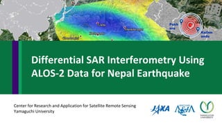
  • 1. Kathm andu Pokh ara Center for Research and Application for Satellite Remote Sensing Yamaguchi University Differential SAR Interferometry Using ALOS-2 Data for Nepal Earthquake
  • 2. This content was created in January 2016 GMTSAR is old version but how to use software is similar. Note
  • 3. GMTSAR is open source (GNU General Public License) for InSAR processing. The system has 3 main components 1. a preprocessor for each satellite data type to convert the native format and orbital information into a generic format 2. an InSAR processor to focus and align stacks of images, map topography into phase, and form the complex interferogram 3. a postprocessor, mostly based on GMT, to filter the interferogram and construct interferometric products of phase, coherence, phase gradient, and line-of sight displacement in both radar and geographic coordinates Advantages of this open source: 1. Some SAR images can be processed from raw image such as ALOS, ENVI, ERS, CSK. 2. InSAR relies on sub-meter orbital accuracy to greatly simplify processing algorithm 3. Process can be automatically processed with no human intervention 4. It provide user friendly interface so users who don’t know programming languages can access these applications easily. 5. It allows users to edit source code. 3 Source: http://topex.ucsd.edu/gmtsar/ Developers: David Sandwell - Scripps Institution of Oceanography Rob Mellors - San Diego State University Xiaopeng Tong - Scripps Institution of Oceanography Meng Wei - Scripps Institution of Oceanography Paul Wessel - University of Hawaii Software : GMTSAR
  • 4. p2p_ALOS.csh process an ALOS interferogram from end-to-end Change Parameter in config file Algorithm and codes for InSAR
  • 5. DInSAR processing : Baja Earthquake Sample data is provided in GMTSAR website http://topex.ucsd.edu/gmtsar/downloads/ Baja Earthquake, California, Mexico Magnitude, 7.2 (USGS, as of 2010-04-09) Master image : 2009 (year) /351 (Day of year) Slave image : 2010/124
  • 8. For window, • Install “Oracle VM” • http://www.oracle.com/technetwork/server-storage/virtualbox/downloads/index.html • Download GMTSAR • Install GMTSAR in Ubuntu virtual machine • http://topex.ucsd.edu/gmtsar/downloads/ If you use Linux based systems (such as Ubuntu and MacOS), It is better to install directly to your operation system Install Program
  • 9. Open “Oracle VM VirtualBox Manager” → click “New” to create virtual machine Change name to “any name” and operating system to “Linux” type and “Ubuntu(32 bit)” version
  • 10. Share your memory size for virtual machine → click “next” Use an existing virtual hard disk file → select file GMTSAR_Ubutu.vmdk → click “create”
  • 11. GMTSAR_Ubuntu32 is created in Oracle VM VirtualBox Manager → click “Start” icon
  • 12. Open “GMTSAR_Ubuntu32” This is GMTSAR version 4 Installed in Ubuntu 32 on window host
  • 13. • DEM can be download from this website: • http://topex.ucsd.edu/gmtsar/demgen/ Download DEM
  • 15. Install GMTSAR in command line Open LXTerminal and type accordingly command line
  • 16. Install GMTSAR in command line GMTSAR is ready to be used
  • 18. Kathmandu Pokhara 25 April 2015 7.8 Magnitude Different SAR Interferometry (DInSAR) Technique for Detecting Nepal Earthquake Deformation Nepal
  • 19. Prepare folders for processing
  • 20. Prepare config file and set parameters We can change some parameters in this file to be suitable for each images pairs
  • 21. ALOS2 SLC DInSAR processing
  • 22. Command to process DInSAR for Nepal earthquake ALOS2 Images
  • 24. Output file will be in “inf” folder
  • 25. Result visualization in Google Earth