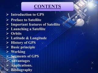
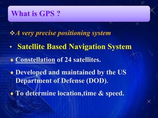
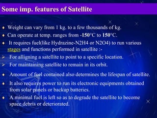
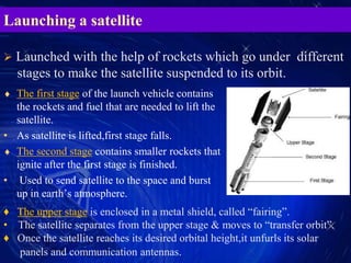
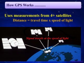
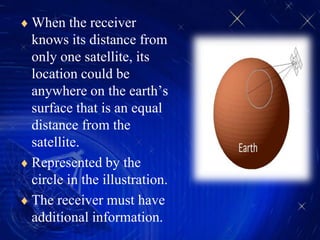
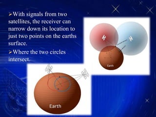
SlideShare a Scribd company logo
Global Positioning System(GPS)
An easy to use
technology for everyone
SATELLITE COMMUNICATION
2
CONTENTS
 Introduction to GPS
 Preface to Satellite
 Important features of Satellite
 Launching a Satellite
 Orbits
 Latitude & Longitude
 History of GPS
 Basic principle
 Working
 Segments of GPS
 Advantages
 Applications.
 Bibliography
What is GPS ?
A very precise positioning system
• Satellite Based Navigation System
 Constellation of 24 satellites.
 Developed and maintained by the US
Department of Defense (DOD).
 To determine location,time & speed.
A Preface to SATELLITE
 Example- Sputnik 1 :
• the first satellite-launched by Soviet Union in 1957.
• is an artificial satellite which revolved around the Earth in an elliptical
orbit in Low Earth Orbit(LEO).
• used to broadcast radio signals.
 Example-Moon :
• Is a natural satellite that revolves around the earth in Lunar orbit.
 an object which revolves around
another reference large body placed
in an orbit into space.
Some imp. features of Satellite
 Weight can vary from 1 kg. to a few thousands of kg.
 Can operate at temp. ranges from -150°C to 150°C.
 It requires fuel(like Hydrazine-N2H4 or N2O4) to run various
stages and functions performed in satellite :-
 For alligning a satellite to point to a specific location.
 For maintaining satellite to remain in its orbit.
 Amount of fuel contained also determines the lifespan of satellite.
 It also requires power to run its electronic equipments obtained
from solar panels or backup batteries.
 A minimal fuel is left so as to degrade the satellite to become
space debris or deteriorated.
Launching a satellite
 The first stage of the launch vehicle contains
the rockets and fuel that are needed to lift the
satellite.
• As satellite is lifted,first stage falls.
 The second stage contains smaller rockets that
ignite after the first stage is finished.
• Used to send satellite to the space and burst
up in earth’s atmosphere.
 Launched with the help of rockets which go under different
stages to make the satellite suspended to its orbit.
♦ The upper stage is enclosed in a metal shield, called “fairing”.
• The satellite separates from the upper stage & moves to “transfer orbit”.
♦ Once the satellite reaches its desired orbital height,it unfurls its solar
panels and communication antennas.
 Launched by ISRO On 4th April 2014 from the Satish Dhawan
Space Center,about 50 miles north of Chennai.
 Weighed 1,432 kg at an altitude of 20,610 km. Geosynchronous
orbit.
 Designed for a 10-year lifetime.
 Five more Indian navigation spacecraft are scheduled for launch by
mid-2015.
Orbits
 An orbit is the
gravitationally curved path
of an object around a point
in space.
 Orbits of planets are
typically elliptical.
Types of ORBITS -:
 LEO
 MEO
 GEO/GSO
 HEO
LEO(LOWER EARTH ORBIT)
 Closest to earth.
 Extends upto an altitude of 160-2000 Km.
 Orbiting period is 90 min.
 Orbital speed is about 28,000-30,000 Km./h
 Have less lifespan-approx. 5 yrs.
 Advantages-
 Access to visit Hubble Space Telescope & International Space Station.
 Only way to go up and do experiments,testing & repairing of satellites.
 High resolution pictures.
 Ozone layer & other atmospheric disturbances monitoring.
 Disadvantages-
 Atmospheric Drag.
 Less Dwell Time.
 Extends upto an altitude of 2000-35,786 Km.(optimum
value-20,000 km.)
 Orbiting period is12 hrs.
 Orbital speed is about 18,000Km./h
 Have an average lifespan-approx. 10 yrs.
 GPS satellites mostly orbits in MEO.
 Advantages-
♦ Used for navigation, communication and space
environment science.
♦ Signal time delay is less.
MEO(MEDIUM EARTH ORBIT)
 Geosynchronous means orbiting its path in synchronization with
Earth.
 Also includes GSO(Geostationary Earth orbit).
 Extends upto an altitude of 35,786 Km and above.
 Orbiting period is 24 hrs.
 Orbital speed is about 14,000Km./h
 Have a good lifespan-approx. 15-18 yrs.
 Advantages -:
 Weather and TV Broadcasting.
 Natural Calamities alert and warning.
 Disadvantages -:
 Introduces large time delays in broadcasting.
GEO(GEOSYNCHRONOUS EARTH ORBIT)
 Extends upto an altitude of 50,000 km. to some
lakhs of km.
 Above this orbit is the-’graveyard Orbit’.
 Orbiting period is some days.
 Orbital speed is about 3,000-5000 Km/h
Example :-
 Moon-have an altitude of 3,85,000 km.
 Orbital speed is 3,600 km/h and takes 25 days
to complete its orbit around the Earth.
HEO(HIGH EARTH ORBIT)
LATITUDE AND LONGITUDE
Latitude - is the angular distance, in degrees,
minutes, and seconds of a point north or south
of the Equator. Lines of latitude are often
referred to as parallels.
Longitude - is the angular distance, in degrees,
minutes, and seconds, of a point east or west of
the Prime (Greenwich) Meridian. Lines of
longitude are often referred to as meridians.
Altitude - is the distance of an object
measured w.r.t ground or sea level usually in
vertical direction.
History of GPS
Ivan A. Getting Roger L. Easton Bradford Parkinson
 GPS was initially created for the United States Air Force by the Raytheon Company.
In 1967, the U.S. Navy launched TRANSIT, the first satellite navigational system,
which was used to help guide the Navy’s submarines-missiles.
1974, the first atomic clocks were put into orbit.
By 1978, the U.S. military had launched the first four GPS satellites.
Until 1983, GPS technology was available for U.S. military use only.
 In 1983,due to a tragedy with Korean Air Lines Flight 007 accident, President
Ronald Reagan (U.S)issued a directive that when GPS technology was operational, it
would be free and available to the world.
On Feb. 14, 1989, the first modern satellite,” USA-35” was launched.
By July 17, 1995, the global positioning system was complete.
Principle of GPS
 TRILATERATION :-
Process to determine your position on a map knowing the
precise distance from three different landmarks using a pair of
compasses. Where the three circles centered on each of the
landmarks overlap,gives you,your location.
In GPS, the calculations are carried out in three-
dimensions with an imaginary set of 3D compasses so that
your location is where three spheres of radius given by the
distance to each of three satellites overlap.
4 satellites gives accuracy.
How GPS Works ………
Uses measurements from 4+ satellites
Distance = travel time x speed of light
Source:Trimble
 Each satellite knows its
position and its distance
from the center of the earth.
 Each satellite constantly
broadcasts this information.
 With this information and
the calculated distance, the
receiver calculates its
position.
 Just knowing the distance
to one satellite doesn’t
provide enough
information.
 When the receiver
knows its distance from
only one satellite, its
location could be
anywhere on the earth’s
surface that is an equal
distance from the
satellite.
 Represented by the
circle in the illustration.
 The receiver must have
additional information.
With signals from two
satellites, the receiver can
narrow down its location to
just two points on the earths
surface.
Where the two circles
intersect.
 Knowing its distance
from three satellites, the
receiver can determine its
location because there is
only two possible
combinations and one of
them is out in space.
 In this example, the
receiver is located at b.
 The more satellite that are
used, the greater the
potential accuracy of the
position location.
Segments of GPS
1. Space Segment
A constellation of 24 satellites
2. Control Segment
A network of earth-based facilities
Source:Trimble
1. Users Segment
Ground, Sky and Marine.
1.Space Segment
 The current GPS configuration consists of
a constellation of 24 satellites(with 6
spares)in high orbits around the Earth.
 Extends at an altitude of about 20,000 km.
 Has an orbital speed of about 14,000 km/hr
& orbital period is roughly 12 hrs.
 The orbits are designed so that there are
always 6 satellites in view,from most
places on the earth.
♦ Powered by solar cells, the satellites continuously
orient themselves to point their solar panels toward
the sun and their antenna toward the earth.
2.Control Segment
 The CS consists of 3 entities:
Master Control Station
Monitor Stations
Ground Antennas
1. Master Control Station
• The master control station, located at Falcon Air Force Base in
Colorado Springs, Colorado, is responsible for overall management of
the remote monitoring and transmission sites.
• Provide commands and control of the GPS constellation.
• It generates and uploads navigation messages and ensures the health
and accuracy of the satellite constellation.
• It receives navigation information from the monitor stations, utilizes
this information to compute the precise locations of the GPS satellites in
space, and then uploads this data to the satellites.
2. Monitor Stations
 Monitor stations track the GPS satellites as they pass overhead and
channel their observations back to the master control station.
 Monitor stations collect atmospheric data, range/carrier
measurements, and navigation signals.
 The sites utilize sophisticated GPS receivers and are operated by
the MCS.
 There are 16 monitoring stations located throughout the world,
including six from the Air Force and 10 from the National
Geospatial-Intelligence Agency (NGA).
3. Ground Antennas
 Ground antennas monitor and track the satellites from horizon to
horizon.
 They also transmit correction information to individual satellites.
3.User Segment
 GPS receivers are generally composed of an antenna, tuned to
the frequencies transmitted by the satellites.
 They can also include a display for showing location and
speed information to the user.
 A receiver is often described by its number of channels this
signifies how many satellites it can monitor simultaneously.
 Some Common Receiver’s are -:
MAP for location of Control Stations
Advantages of GPS
Free of cost
Easy to use
Reliable to much extent
Unlimited Users Capacity
Operates in all Weather conditions
Complete coverage of Globe
Updated regularly
Compact-Mobile phones/Watches
Full time access
Determination of exact location,distance & speed.
Gives you inf. About Latitude & Longitude.
Allows to search for nearby Ammenities.
Determination of traffic,weather conditions.
Keep track of your friend’s or target’s location.
Applications of GPS
 ROAD APPLICATIONS
 Used to determine location,speed,traffic and distance to destination.
 Used to search nearby Ammenities like malls,restaurants,theatres etc.
 Sources include-Mobiles,Laptos,GPS mount for automobiles.
 SPACE APPLICATIONS
 Weather monitoring, Launch Vehicle tracking, Disaster Alerts,Space Shuttle nav.
 Keep track of other space elements like space debris,asteroids,etc.
 RAIL APPLICATIONS
 To maintain smooth flow of traffic.
 Prevent collisions by precise knowledge of other trains locations.
 MILITARY: GPS systems are installed with fighters, bombers, tankers, helicopters,
ships, submarines, tanks, jeeps and soldiers to combat various attacks.
 AVIATION APPLICATIONS: GPS provides position determination for all phases
of flight from departure, en route, and arrival, to airport surface navigation.
 AGRICULTURE: farm planning, field mapping, soil sampling, tractor guidance,
crop scouting, variable rate applications, and yield mapping.
Bibliography
 www.wikipedia.org
 www.youtube.com
 www.astronomy.ohio-state.edu
 www.mio.com
 www.cfa.harvard.edu
 www.gpspassion.com
 www.lockheedmartin.co.in
 http://gps.about.com/
GPS

More Related Content

What's hot

introduction-of-GNSS-1
introduction-of-GNSS-1introduction-of-GNSS-1
introduction-of-GNSS-1
Kutubuddin ANSARI
 
Global Positing System
Global Positing SystemGlobal Positing System
Global Positing System
Pranay Mondal
 
Global Positioning System (GPS)
Global Positioning System (GPS) Global Positioning System (GPS)
Global Positioning System (GPS)
ManjuChauhan16
 
GPS (Global Positioning System)
GPS (Global Positioning System)GPS (Global Positioning System)
GPS (Global Positioning System)
TANMAY SHARMA
 
Global navigation satellite system based positioning combined
Global navigation satellite system based positioning   combinedGlobal navigation satellite system based positioning   combined
Global navigation satellite system based positioning combined
Mehjabin Sultana
 
Global positioning system
Global positioning systemGlobal positioning system
Global positioning system
dhara dattani
 
Introduction to GNSS (1)
Introduction to GNSS (1)Introduction to GNSS (1)
Introduction to GNSS (1)
NopphawanTamkuan
 
Gps
GpsGps
Gps
GpsGps
Global positioning system (gps)
Global positioning system (gps)Global positioning system (gps)
Global positioning system (gps)
aditya singh
 
GPS(Global Positioning system
GPS(Global Positioning systemGPS(Global Positioning system
GPS(Global Positioning system
tanmoy chakrabortty
 
Introduction to GPS
Introduction to GPSIntroduction to GPS
Introduction to GPS
Daniel Kim
 
Geodetic systems
Geodetic systemsGeodetic systems
Geodetic systems
Moses Robby
 
IRNSS by Sree Bhargava
IRNSS by Sree BhargavaIRNSS by Sree Bhargava
IRNSS by Sree Bhargava
Sree Bhargava Kothapalli
 
GPS
GPSGPS
gps
gpsgps
Introduction of gps global navigation satellite systems
Introduction of gps   global navigation satellite systems Introduction of gps   global navigation satellite systems
Introduction of gps global navigation satellite systems DocumentStory
 
Introduction to global position system
Introduction to global position systemIntroduction to global position system
Introduction to global position system
University of Technology
 

What's hot (20)

introduction-of-GNSS-1
introduction-of-GNSS-1introduction-of-GNSS-1
introduction-of-GNSS-1
 
Global Positing System
Global Positing SystemGlobal Positing System
Global Positing System
 
How gps works
How gps worksHow gps works
How gps works
 
Global Positioning System (GPS)
Global Positioning System (GPS) Global Positioning System (GPS)
Global Positioning System (GPS)
 
GPS (Global Positioning System)
GPS (Global Positioning System)GPS (Global Positioning System)
GPS (Global Positioning System)
 
Global navigation satellite system based positioning combined
Global navigation satellite system based positioning   combinedGlobal navigation satellite system based positioning   combined
Global navigation satellite system based positioning combined
 
Global positioning system
Global positioning systemGlobal positioning system
Global positioning system
 
GNSS
GNSSGNSS
GNSS
 
Introduction to GNSS (1)
Introduction to GNSS (1)Introduction to GNSS (1)
Introduction to GNSS (1)
 
Gps
GpsGps
Gps
 
Gps
GpsGps
Gps
 
Global positioning system (gps)
Global positioning system (gps)Global positioning system (gps)
Global positioning system (gps)
 
GPS(Global Positioning system
GPS(Global Positioning systemGPS(Global Positioning system
GPS(Global Positioning system
 
Introduction to GPS
Introduction to GPSIntroduction to GPS
Introduction to GPS
 
Geodetic systems
Geodetic systemsGeodetic systems
Geodetic systems
 
IRNSS by Sree Bhargava
IRNSS by Sree BhargavaIRNSS by Sree Bhargava
IRNSS by Sree Bhargava
 
GPS
GPSGPS
GPS
 
gps
gpsgps
gps
 
Introduction of gps global navigation satellite systems
Introduction of gps   global navigation satellite systems Introduction of gps   global navigation satellite systems
Introduction of gps global navigation satellite systems
 
Introduction to global position system
Introduction to global position systemIntroduction to global position system
Introduction to global position system
 

Viewers also liked

Geocaching - Adams
Geocaching - AdamsGeocaching - Adams
Geocaching - Adams
sadamsrjh
 
Aerospace Engineers for Dummies | What You Need To Know In 15 Slides
Aerospace Engineers for Dummies | What You Need To Know In 15 SlidesAerospace Engineers for Dummies | What You Need To Know In 15 Slides
Aerospace Engineers for Dummies | What You Need To Know In 15 Slides
OwlGuru.com
 
Comparatives and superlatives
Comparatives and superlativesComparatives and superlatives
Comparatives and superlatives
Henrique Semeghini
 
NDT Session 4
NDT Session 4NDT Session 4
NDT Session 4
Farrukh Rasheed
 
GPS [ Global Positioning System ]
GPS [ Global Positioning System ]GPS [ Global Positioning System ]
GPS [ Global Positioning System ]
Akshit Gupta
 
GPS Orbits
GPS OrbitsGPS Orbits
GPS Orbits
Vrince Vimal
 
GPS sattelite orbit
GPS sattelite orbitGPS sattelite orbit
GPS sattelite orbit
Kutubuddin ANSARI
 
Gps and remote sensing
Gps and remote sensingGps and remote sensing
Gps and remote sensing
Sanila Khalid
 
GPS application soil survey
GPS application soil surveyGPS application soil survey
GPS application soil survey
Dr. Md. Altaf Hossain
 
Transferencia de massa livro
Transferencia de massa livroTransferencia de massa livro
Transferencia de massa livro
Luciano Costa
 
Pic18 f4520 and robotics
Pic18 f4520 and roboticsPic18 f4520 and robotics
Pic18 f4520 and roboticsSiddhant Chopra
 

Viewers also liked (13)

GPS
GPS GPS
GPS
 
Geocaching - Adams
Geocaching - AdamsGeocaching - Adams
Geocaching - Adams
 
term paper 2
term paper 2term paper 2
term paper 2
 
Aerospace Engineers for Dummies | What You Need To Know In 15 Slides
Aerospace Engineers for Dummies | What You Need To Know In 15 SlidesAerospace Engineers for Dummies | What You Need To Know In 15 Slides
Aerospace Engineers for Dummies | What You Need To Know In 15 Slides
 
Comparatives and superlatives
Comparatives and superlativesComparatives and superlatives
Comparatives and superlatives
 
NDT Session 4
NDT Session 4NDT Session 4
NDT Session 4
 
GPS [ Global Positioning System ]
GPS [ Global Positioning System ]GPS [ Global Positioning System ]
GPS [ Global Positioning System ]
 
GPS Orbits
GPS OrbitsGPS Orbits
GPS Orbits
 
GPS sattelite orbit
GPS sattelite orbitGPS sattelite orbit
GPS sattelite orbit
 
Gps and remote sensing
Gps and remote sensingGps and remote sensing
Gps and remote sensing
 
GPS application soil survey
GPS application soil surveyGPS application soil survey
GPS application soil survey
 
Transferencia de massa livro
Transferencia de massa livroTransferencia de massa livro
Transferencia de massa livro
 
Pic18 f4520 and robotics
Pic18 f4520 and roboticsPic18 f4520 and robotics
Pic18 f4520 and robotics
 

Similar to GPS

Sc ppt -jntuworld.com__jwfiles
Sc ppt -jntuworld.com__jwfilesSc ppt -jntuworld.com__jwfiles
Sc ppt -jntuworld.com__jwfilesBrem Kumar
 
Satellite Applications
Satellite ApplicationsSatellite Applications
Satellite Applications
Serhan
 
satellite-communications
satellite-communicationssatellite-communications
satellite-communications
jhcid
 
Global Positioning System
Global Positioning SystemGlobal Positioning System
Global Positioning SystemIshwar Bulbule
 
Satellites System
Satellites SystemSatellites System
Satellites System
Syed Abu Hamza
 
Global Positioning System
Global Positioning SystemGlobal Positioning System
Global Positioning System
Gaurav Raj
 
Satellite System
Satellite SystemSatellite System
Satellite System
Shamima Akther
 
GPSS ,DEFENITION,TYPE,WORKING,PRINCIPLES
GPSS ,DEFENITION,TYPE,WORKING,PRINCIPLESGPSS ,DEFENITION,TYPE,WORKING,PRINCIPLES
GPSS ,DEFENITION,TYPE,WORKING,PRINCIPLES
SALIAALIAS
 
Remote Sensing.pptx
Remote Sensing.pptxRemote Sensing.pptx
Remote Sensing.pptx
NEERAJ RANI
 
Gps final main
Gps final mainGps final main
Gps final main
Viksit Jadon
 
Global positioning system
Global positioning systemGlobal positioning system
Global positioning system
jananisivakumar97
 
558215 634216980498557500
558215 634216980498557500558215 634216980498557500
558215 634216980498557500
Rahul Mundra
 
GIS FINAL REPORT.pdf
GIS FINAL REPORT.pdfGIS FINAL REPORT.pdf
GIS FINAL REPORT.pdf
KumarSatyam263033
 
Introduction to setelite system
Introduction to setelite systemIntroduction to setelite system
Introduction to setelite system
sheikhparvez4
 
ongc satellite communication
 ongc satellite communication ongc satellite communication
ongc satellite communication
Nitin Tomar
 
Global Positioning system GPS - Dr. S. Balamurugan
Global Positioning system GPS - Dr. S. BalamuruganGlobal Positioning system GPS - Dr. S. Balamurugan
Global Positioning system GPS - Dr. S. Balamurugan
Prakash Kumar Sekar
 
Satellite network
Satellite networkSatellite network
Satellite network
Md. Ahsanul Haque Millat
 
Satellites .
Satellites . Satellites .
Satellites .
Mohamed Omer
 

Similar to GPS (20)

Sc ppt -jntuworld.com__jwfiles
Sc ppt -jntuworld.com__jwfilesSc ppt -jntuworld.com__jwfiles
Sc ppt -jntuworld.com__jwfiles
 
Satellite Applications
Satellite ApplicationsSatellite Applications
Satellite Applications
 
satellite-communications
satellite-communicationssatellite-communications
satellite-communications
 
Global Positioning System
Global Positioning SystemGlobal Positioning System
Global Positioning System
 
Seminar
SeminarSeminar
Seminar
 
Satellites System
Satellites SystemSatellites System
Satellites System
 
Global Positioning System
Global Positioning SystemGlobal Positioning System
Global Positioning System
 
Satcom 5
Satcom 5Satcom 5
Satcom 5
 
Satellite System
Satellite SystemSatellite System
Satellite System
 
GPSS ,DEFENITION,TYPE,WORKING,PRINCIPLES
GPSS ,DEFENITION,TYPE,WORKING,PRINCIPLESGPSS ,DEFENITION,TYPE,WORKING,PRINCIPLES
GPSS ,DEFENITION,TYPE,WORKING,PRINCIPLES
 
Remote Sensing.pptx
Remote Sensing.pptxRemote Sensing.pptx
Remote Sensing.pptx
 
Gps final main
Gps final mainGps final main
Gps final main
 
Global positioning system
Global positioning systemGlobal positioning system
Global positioning system
 
558215 634216980498557500
558215 634216980498557500558215 634216980498557500
558215 634216980498557500
 
GIS FINAL REPORT.pdf
GIS FINAL REPORT.pdfGIS FINAL REPORT.pdf
GIS FINAL REPORT.pdf
 
Introduction to setelite system
Introduction to setelite systemIntroduction to setelite system
Introduction to setelite system
 
ongc satellite communication
 ongc satellite communication ongc satellite communication
ongc satellite communication
 
Global Positioning system GPS - Dr. S. Balamurugan
Global Positioning system GPS - Dr. S. BalamuruganGlobal Positioning system GPS - Dr. S. Balamurugan
Global Positioning system GPS - Dr. S. Balamurugan
 
Satellite network
Satellite networkSatellite network
Satellite network
 
Satellites .
Satellites . Satellites .
Satellites .
 

Recently uploaded

ethical hacking in wireless-hacking1.ppt
ethical hacking in wireless-hacking1.pptethical hacking in wireless-hacking1.ppt
ethical hacking in wireless-hacking1.ppt
Jayaprasanna4
 
Design and Analysis of Algorithms-DP,Backtracking,Graphs,B&B
Design and Analysis of Algorithms-DP,Backtracking,Graphs,B&BDesign and Analysis of Algorithms-DP,Backtracking,Graphs,B&B
Design and Analysis of Algorithms-DP,Backtracking,Graphs,B&B
Sreedhar Chowdam
 
CFD Simulation of By-pass Flow in a HRSG module by R&R Consult.pptx
CFD Simulation of By-pass Flow in a HRSG module by R&R Consult.pptxCFD Simulation of By-pass Flow in a HRSG module by R&R Consult.pptx
CFD Simulation of By-pass Flow in a HRSG module by R&R Consult.pptx
R&R Consult
 
TECHNICAL TRAINING MANUAL GENERAL FAMILIARIZATION COURSE
TECHNICAL TRAINING MANUAL   GENERAL FAMILIARIZATION COURSETECHNICAL TRAINING MANUAL   GENERAL FAMILIARIZATION COURSE
TECHNICAL TRAINING MANUAL GENERAL FAMILIARIZATION COURSE
DuvanRamosGarzon1
 
Forklift Classes Overview by Intella Parts
Forklift Classes Overview by Intella PartsForklift Classes Overview by Intella Parts
Forklift Classes Overview by Intella Parts
Intella Parts
 
Vaccine management system project report documentation..pdf
Vaccine management system project report documentation..pdfVaccine management system project report documentation..pdf
Vaccine management system project report documentation..pdf
Kamal Acharya
 
Immunizing Image Classifiers Against Localized Adversary Attacks
Immunizing Image Classifiers Against Localized Adversary AttacksImmunizing Image Classifiers Against Localized Adversary Attacks
Immunizing Image Classifiers Against Localized Adversary Attacks
gerogepatton
 
Courier management system project report.pdf
Courier management system project report.pdfCourier management system project report.pdf
Courier management system project report.pdf
Kamal Acharya
 
ethical hacking-mobile hacking methods.ppt
ethical hacking-mobile hacking methods.pptethical hacking-mobile hacking methods.ppt
ethical hacking-mobile hacking methods.ppt
Jayaprasanna4
 
block diagram and signal flow graph representation
block diagram and signal flow graph representationblock diagram and signal flow graph representation
block diagram and signal flow graph representation
Divya Somashekar
 
power quality voltage fluctuation UNIT - I.pptx
power quality voltage fluctuation UNIT - I.pptxpower quality voltage fluctuation UNIT - I.pptx
power quality voltage fluctuation UNIT - I.pptx
ViniHema
 
Gen AI Study Jams _ For the GDSC Leads in India.pdf
Gen AI Study Jams _ For the GDSC Leads in India.pdfGen AI Study Jams _ For the GDSC Leads in India.pdf
Gen AI Study Jams _ For the GDSC Leads in India.pdf
gdsczhcet
 
CME397 Surface Engineering- Professional Elective
CME397 Surface Engineering- Professional ElectiveCME397 Surface Engineering- Professional Elective
CME397 Surface Engineering- Professional Elective
karthi keyan
 
ASME IX(9) 2007 Full Version .pdf
ASME IX(9)  2007 Full Version       .pdfASME IX(9)  2007 Full Version       .pdf
ASME IX(9) 2007 Full Version .pdf
AhmedHussein950959
 
Water Industry Process Automation and Control Monthly - May 2024.pdf
Water Industry Process Automation and Control Monthly - May 2024.pdfWater Industry Process Automation and Control Monthly - May 2024.pdf
Water Industry Process Automation and Control Monthly - May 2024.pdf
Water Industry Process Automation & Control
 
weather web application report.pdf
weather web application report.pdfweather web application report.pdf
weather web application report.pdf
Pratik Pawar
 
AKS UNIVERSITY Satna Final Year Project By OM Hardaha.pdf
AKS UNIVERSITY Satna Final Year Project By OM Hardaha.pdfAKS UNIVERSITY Satna Final Year Project By OM Hardaha.pdf
AKS UNIVERSITY Satna Final Year Project By OM Hardaha.pdf
SamSarthak3
 
Democratizing Fuzzing at Scale by Abhishek Arya
Democratizing Fuzzing at Scale by Abhishek AryaDemocratizing Fuzzing at Scale by Abhishek Arya
Democratizing Fuzzing at Scale by Abhishek Arya
abh.arya
 
Sachpazis:Terzaghi Bearing Capacity Estimation in simple terms with Calculati...
Sachpazis:Terzaghi Bearing Capacity Estimation in simple terms with Calculati...Sachpazis:Terzaghi Bearing Capacity Estimation in simple terms with Calculati...
Sachpazis:Terzaghi Bearing Capacity Estimation in simple terms with Calculati...
Dr.Costas Sachpazis
 
Railway Signalling Principles Edition 3.pdf
Railway Signalling Principles Edition 3.pdfRailway Signalling Principles Edition 3.pdf
Railway Signalling Principles Edition 3.pdf
TeeVichai
 

Recently uploaded (20)

ethical hacking in wireless-hacking1.ppt
ethical hacking in wireless-hacking1.pptethical hacking in wireless-hacking1.ppt
ethical hacking in wireless-hacking1.ppt
 
Design and Analysis of Algorithms-DP,Backtracking,Graphs,B&B
Design and Analysis of Algorithms-DP,Backtracking,Graphs,B&BDesign and Analysis of Algorithms-DP,Backtracking,Graphs,B&B
Design and Analysis of Algorithms-DP,Backtracking,Graphs,B&B
 
CFD Simulation of By-pass Flow in a HRSG module by R&R Consult.pptx
CFD Simulation of By-pass Flow in a HRSG module by R&R Consult.pptxCFD Simulation of By-pass Flow in a HRSG module by R&R Consult.pptx
CFD Simulation of By-pass Flow in a HRSG module by R&R Consult.pptx
 
TECHNICAL TRAINING MANUAL GENERAL FAMILIARIZATION COURSE
TECHNICAL TRAINING MANUAL   GENERAL FAMILIARIZATION COURSETECHNICAL TRAINING MANUAL   GENERAL FAMILIARIZATION COURSE
TECHNICAL TRAINING MANUAL GENERAL FAMILIARIZATION COURSE
 
Forklift Classes Overview by Intella Parts
Forklift Classes Overview by Intella PartsForklift Classes Overview by Intella Parts
Forklift Classes Overview by Intella Parts
 
Vaccine management system project report documentation..pdf
Vaccine management system project report documentation..pdfVaccine management system project report documentation..pdf
Vaccine management system project report documentation..pdf
 
Immunizing Image Classifiers Against Localized Adversary Attacks
Immunizing Image Classifiers Against Localized Adversary AttacksImmunizing Image Classifiers Against Localized Adversary Attacks
Immunizing Image Classifiers Against Localized Adversary Attacks
 
Courier management system project report.pdf
Courier management system project report.pdfCourier management system project report.pdf
Courier management system project report.pdf
 
ethical hacking-mobile hacking methods.ppt
ethical hacking-mobile hacking methods.pptethical hacking-mobile hacking methods.ppt
ethical hacking-mobile hacking methods.ppt
 
block diagram and signal flow graph representation
block diagram and signal flow graph representationblock diagram and signal flow graph representation
block diagram and signal flow graph representation
 
power quality voltage fluctuation UNIT - I.pptx
power quality voltage fluctuation UNIT - I.pptxpower quality voltage fluctuation UNIT - I.pptx
power quality voltage fluctuation UNIT - I.pptx
 
Gen AI Study Jams _ For the GDSC Leads in India.pdf
Gen AI Study Jams _ For the GDSC Leads in India.pdfGen AI Study Jams _ For the GDSC Leads in India.pdf
Gen AI Study Jams _ For the GDSC Leads in India.pdf
 
CME397 Surface Engineering- Professional Elective
CME397 Surface Engineering- Professional ElectiveCME397 Surface Engineering- Professional Elective
CME397 Surface Engineering- Professional Elective
 
ASME IX(9) 2007 Full Version .pdf
ASME IX(9)  2007 Full Version       .pdfASME IX(9)  2007 Full Version       .pdf
ASME IX(9) 2007 Full Version .pdf
 
Water Industry Process Automation and Control Monthly - May 2024.pdf
Water Industry Process Automation and Control Monthly - May 2024.pdfWater Industry Process Automation and Control Monthly - May 2024.pdf
Water Industry Process Automation and Control Monthly - May 2024.pdf
 
weather web application report.pdf
weather web application report.pdfweather web application report.pdf
weather web application report.pdf
 
AKS UNIVERSITY Satna Final Year Project By OM Hardaha.pdf
AKS UNIVERSITY Satna Final Year Project By OM Hardaha.pdfAKS UNIVERSITY Satna Final Year Project By OM Hardaha.pdf
AKS UNIVERSITY Satna Final Year Project By OM Hardaha.pdf
 
Democratizing Fuzzing at Scale by Abhishek Arya
Democratizing Fuzzing at Scale by Abhishek AryaDemocratizing Fuzzing at Scale by Abhishek Arya
Democratizing Fuzzing at Scale by Abhishek Arya
 
Sachpazis:Terzaghi Bearing Capacity Estimation in simple terms with Calculati...
Sachpazis:Terzaghi Bearing Capacity Estimation in simple terms with Calculati...Sachpazis:Terzaghi Bearing Capacity Estimation in simple terms with Calculati...
Sachpazis:Terzaghi Bearing Capacity Estimation in simple terms with Calculati...
 
Railway Signalling Principles Edition 3.pdf
Railway Signalling Principles Edition 3.pdfRailway Signalling Principles Edition 3.pdf
Railway Signalling Principles Edition 3.pdf
 

GPS

  • 1. Global Positioning System(GPS) An easy to use technology for everyone SATELLITE COMMUNICATION
  • 2. 2 CONTENTS  Introduction to GPS  Preface to Satellite  Important features of Satellite  Launching a Satellite  Orbits  Latitude & Longitude  History of GPS  Basic principle  Working  Segments of GPS  Advantages  Applications.  Bibliography
  • 3. What is GPS ? A very precise positioning system • Satellite Based Navigation System  Constellation of 24 satellites.  Developed and maintained by the US Department of Defense (DOD).  To determine location,time & speed.
  • 4. A Preface to SATELLITE  Example- Sputnik 1 : • the first satellite-launched by Soviet Union in 1957. • is an artificial satellite which revolved around the Earth in an elliptical orbit in Low Earth Orbit(LEO). • used to broadcast radio signals.  Example-Moon : • Is a natural satellite that revolves around the earth in Lunar orbit.  an object which revolves around another reference large body placed in an orbit into space.
  • 5. Some imp. features of Satellite  Weight can vary from 1 kg. to a few thousands of kg.  Can operate at temp. ranges from -150°C to 150°C.  It requires fuel(like Hydrazine-N2H4 or N2O4) to run various stages and functions performed in satellite :-  For alligning a satellite to point to a specific location.  For maintaining satellite to remain in its orbit.  Amount of fuel contained also determines the lifespan of satellite.  It also requires power to run its electronic equipments obtained from solar panels or backup batteries.  A minimal fuel is left so as to degrade the satellite to become space debris or deteriorated.
  • 6. Launching a satellite  The first stage of the launch vehicle contains the rockets and fuel that are needed to lift the satellite. • As satellite is lifted,first stage falls.  The second stage contains smaller rockets that ignite after the first stage is finished. • Used to send satellite to the space and burst up in earth’s atmosphere.  Launched with the help of rockets which go under different stages to make the satellite suspended to its orbit. ♦ The upper stage is enclosed in a metal shield, called “fairing”. • The satellite separates from the upper stage & moves to “transfer orbit”. ♦ Once the satellite reaches its desired orbital height,it unfurls its solar panels and communication antennas.
  • 7.  Launched by ISRO On 4th April 2014 from the Satish Dhawan Space Center,about 50 miles north of Chennai.  Weighed 1,432 kg at an altitude of 20,610 km. Geosynchronous orbit.  Designed for a 10-year lifetime.  Five more Indian navigation spacecraft are scheduled for launch by mid-2015.
  • 8. Orbits  An orbit is the gravitationally curved path of an object around a point in space.  Orbits of planets are typically elliptical. Types of ORBITS -:  LEO  MEO  GEO/GSO  HEO
  • 9. LEO(LOWER EARTH ORBIT)  Closest to earth.  Extends upto an altitude of 160-2000 Km.  Orbiting period is 90 min.  Orbital speed is about 28,000-30,000 Km./h  Have less lifespan-approx. 5 yrs.  Advantages-  Access to visit Hubble Space Telescope & International Space Station.  Only way to go up and do experiments,testing & repairing of satellites.  High resolution pictures.  Ozone layer & other atmospheric disturbances monitoring.  Disadvantages-  Atmospheric Drag.  Less Dwell Time.
  • 10.  Extends upto an altitude of 2000-35,786 Km.(optimum value-20,000 km.)  Orbiting period is12 hrs.  Orbital speed is about 18,000Km./h  Have an average lifespan-approx. 10 yrs.  GPS satellites mostly orbits in MEO.  Advantages- ♦ Used for navigation, communication and space environment science. ♦ Signal time delay is less. MEO(MEDIUM EARTH ORBIT)
  • 11.  Geosynchronous means orbiting its path in synchronization with Earth.  Also includes GSO(Geostationary Earth orbit).  Extends upto an altitude of 35,786 Km and above.  Orbiting period is 24 hrs.  Orbital speed is about 14,000Km./h  Have a good lifespan-approx. 15-18 yrs.  Advantages -:  Weather and TV Broadcasting.  Natural Calamities alert and warning.  Disadvantages -:  Introduces large time delays in broadcasting. GEO(GEOSYNCHRONOUS EARTH ORBIT)
  • 12.  Extends upto an altitude of 50,000 km. to some lakhs of km.  Above this orbit is the-’graveyard Orbit’.  Orbiting period is some days.  Orbital speed is about 3,000-5000 Km/h Example :-  Moon-have an altitude of 3,85,000 km.  Orbital speed is 3,600 km/h and takes 25 days to complete its orbit around the Earth. HEO(HIGH EARTH ORBIT)
  • 13. LATITUDE AND LONGITUDE Latitude - is the angular distance, in degrees, minutes, and seconds of a point north or south of the Equator. Lines of latitude are often referred to as parallels. Longitude - is the angular distance, in degrees, minutes, and seconds, of a point east or west of the Prime (Greenwich) Meridian. Lines of longitude are often referred to as meridians. Altitude - is the distance of an object measured w.r.t ground or sea level usually in vertical direction.
  • 14. History of GPS Ivan A. Getting Roger L. Easton Bradford Parkinson  GPS was initially created for the United States Air Force by the Raytheon Company. In 1967, the U.S. Navy launched TRANSIT, the first satellite navigational system, which was used to help guide the Navy’s submarines-missiles. 1974, the first atomic clocks were put into orbit. By 1978, the U.S. military had launched the first four GPS satellites. Until 1983, GPS technology was available for U.S. military use only.  In 1983,due to a tragedy with Korean Air Lines Flight 007 accident, President Ronald Reagan (U.S)issued a directive that when GPS technology was operational, it would be free and available to the world. On Feb. 14, 1989, the first modern satellite,” USA-35” was launched. By July 17, 1995, the global positioning system was complete.
  • 15. Principle of GPS  TRILATERATION :- Process to determine your position on a map knowing the precise distance from three different landmarks using a pair of compasses. Where the three circles centered on each of the landmarks overlap,gives you,your location. In GPS, the calculations are carried out in three- dimensions with an imaginary set of 3D compasses so that your location is where three spheres of radius given by the distance to each of three satellites overlap. 4 satellites gives accuracy.
  • 16. How GPS Works ……… Uses measurements from 4+ satellites Distance = travel time x speed of light Source:Trimble
  • 17.  Each satellite knows its position and its distance from the center of the earth.  Each satellite constantly broadcasts this information.  With this information and the calculated distance, the receiver calculates its position.  Just knowing the distance to one satellite doesn’t provide enough information.
  • 18.  When the receiver knows its distance from only one satellite, its location could be anywhere on the earth’s surface that is an equal distance from the satellite.  Represented by the circle in the illustration.  The receiver must have additional information.
  • 19. With signals from two satellites, the receiver can narrow down its location to just two points on the earths surface. Where the two circles intersect.
  • 20.  Knowing its distance from three satellites, the receiver can determine its location because there is only two possible combinations and one of them is out in space.  In this example, the receiver is located at b.  The more satellite that are used, the greater the potential accuracy of the position location.
  • 21. Segments of GPS 1. Space Segment A constellation of 24 satellites 2. Control Segment A network of earth-based facilities Source:Trimble 1. Users Segment Ground, Sky and Marine.
  • 22. 1.Space Segment  The current GPS configuration consists of a constellation of 24 satellites(with 6 spares)in high orbits around the Earth.  Extends at an altitude of about 20,000 km.  Has an orbital speed of about 14,000 km/hr & orbital period is roughly 12 hrs.  The orbits are designed so that there are always 6 satellites in view,from most places on the earth. ♦ Powered by solar cells, the satellites continuously orient themselves to point their solar panels toward the sun and their antenna toward the earth.
  • 23. 2.Control Segment  The CS consists of 3 entities: Master Control Station Monitor Stations Ground Antennas 1. Master Control Station • The master control station, located at Falcon Air Force Base in Colorado Springs, Colorado, is responsible for overall management of the remote monitoring and transmission sites. • Provide commands and control of the GPS constellation. • It generates and uploads navigation messages and ensures the health and accuracy of the satellite constellation. • It receives navigation information from the monitor stations, utilizes this information to compute the precise locations of the GPS satellites in space, and then uploads this data to the satellites.
  • 24. 2. Monitor Stations  Monitor stations track the GPS satellites as they pass overhead and channel their observations back to the master control station.  Monitor stations collect atmospheric data, range/carrier measurements, and navigation signals.  The sites utilize sophisticated GPS receivers and are operated by the MCS.  There are 16 monitoring stations located throughout the world, including six from the Air Force and 10 from the National Geospatial-Intelligence Agency (NGA). 3. Ground Antennas  Ground antennas monitor and track the satellites from horizon to horizon.  They also transmit correction information to individual satellites.
  • 25. 3.User Segment  GPS receivers are generally composed of an antenna, tuned to the frequencies transmitted by the satellites.  They can also include a display for showing location and speed information to the user.  A receiver is often described by its number of channels this signifies how many satellites it can monitor simultaneously.  Some Common Receiver’s are -:
  • 26. MAP for location of Control Stations
  • 27. Advantages of GPS Free of cost Easy to use Reliable to much extent Unlimited Users Capacity Operates in all Weather conditions Complete coverage of Globe Updated regularly Compact-Mobile phones/Watches Full time access Determination of exact location,distance & speed. Gives you inf. About Latitude & Longitude. Allows to search for nearby Ammenities. Determination of traffic,weather conditions. Keep track of your friend’s or target’s location.
  • 28. Applications of GPS  ROAD APPLICATIONS  Used to determine location,speed,traffic and distance to destination.  Used to search nearby Ammenities like malls,restaurants,theatres etc.  Sources include-Mobiles,Laptos,GPS mount for automobiles.  SPACE APPLICATIONS  Weather monitoring, Launch Vehicle tracking, Disaster Alerts,Space Shuttle nav.  Keep track of other space elements like space debris,asteroids,etc.  RAIL APPLICATIONS  To maintain smooth flow of traffic.  Prevent collisions by precise knowledge of other trains locations.  MILITARY: GPS systems are installed with fighters, bombers, tankers, helicopters, ships, submarines, tanks, jeeps and soldiers to combat various attacks.  AVIATION APPLICATIONS: GPS provides position determination for all phases of flight from departure, en route, and arrival, to airport surface navigation.  AGRICULTURE: farm planning, field mapping, soil sampling, tractor guidance, crop scouting, variable rate applications, and yield mapping.
  • 29. Bibliography  www.wikipedia.org  www.youtube.com  www.astronomy.ohio-state.edu  www.mio.com  www.cfa.harvard.edu  www.gpspassion.com  www.lockheedmartin.co.in  http://gps.about.com/