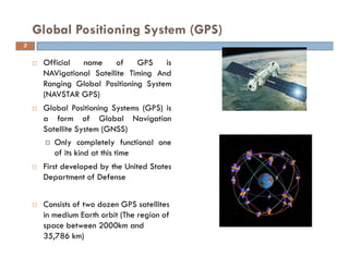
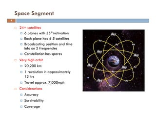
Remote sensing and GIS are useful tools for civil engineering projects. The Global Positioning System (GPS) uses 24 satellites that orbit the earth to provide location and time information to GPS receivers. It has three segments: space (satellites), control (monitoring stations), and user (receivers). GPS works by precisely measuring the time it takes signals from multiple satellites to reach a receiver, allowing the device to triangulate its position. Its applications include navigation, mapping, precision agriculture, and more. Other global satellite systems include GLONASS, Galileo, BeiDou, and future systems like Compass.
Global positioning system and its mathematical form.
By Mustahsan Khan _ BS(physics-Nanotechnology) (International Islamic University Islamabad) Pakistan.
Global positioning system and its mathematical form.
By Mustahsan Khan _ BS(physics-Nanotechnology) (International Islamic University Islamabad) Pakistan.
Differential Global Positioning System (DGPS) is an enhancement to Global Positioning System that provides improved location accuracy, from the
15-meter nominal GPS accuracy to about 10 cm in case of the best implementations. Differential Global Positioning System (DGPS) is a method of providing differential corrections to a Global Positioning System (GPS) receiver in order to improve the accuracy of the navigation solution. DGPS corrections originate from a reference station at a known location. The receivers in these reference stations can estimate errors in the GPS because, unlike the general population of GPS receivers, they have an accurate knowledge of their position.
DGPS uses a network of fixed, ground-based reference stations to broadcast the difference between the positions indicated by the GPS (satellite) systems and the known fixed positions. These stations broadcast the difference between the measured satellite pseudoranges and actual (internally computed) pseudoranges, and receiver stations may correct their pseudoranges by the same amount. The digital correction signal is typically broadcast locally over ground-based transmitters of shorter range.
This content introduces the Global Navigation Satellite System (GNSS), its example, earth observation orbit types, coordinate systems, GNSS time system, converting height (ellipsoidal, geoid, orthometric heights) and various GNSS applications.
These applications fall into five :Location - determining a basic position Navigation - getting from one location to another Tracking - monitoring the movement of people/things Mapping - creating maps of the world Timing - bringing precise timing to the world
Application of differential systems in global navigation satellite systemsAli N.Khojasteh
Global Navigation Satellite Systems (GNSS) include different parts such as control and monitoring stations for the Earth and space settings. Timing, positioning, and control of navigation methods are the main outputs of GNSS. Based on Approach Procedure with Vertical guidance (APV), local and global Satellite Navigation Systems used for positioning and precision approach in aviation instead of present systems like Instrumental Landing Systems (ILS) and its future predict of ICAO. But these systems have errors in positioning and
velocity measurements. The differential corrections are determined by single or multiple reference stations. The single reference station concept is simple but the position accuracy is decreases. This article compares differential systems methods for correcting the errors.
The students can learn about basics of image processing using matlab.
It explains the image operations with the help of examples and Matlab codes.
Students can fine sample images and .m code from the link given in slides.
This lecture is about particle image velocimetry technique. It include discussion about the basic element of PIV setup, image capturing, laser lights, synchronize and correlation analysis.
TECHNICAL TRAINING MANUAL GENERAL FAMILIARIZATION COURSEDuvanRamosGarzon1
AIRCRAFT GENERAL
The Single Aisle is the most advanced family aircraft in service today, with fly-by-wire flight controls.
The A318, A319, A320 and A321 are twin-engine subsonic medium range aircraft.
The family offers a choice of engines
NO1 Uk best vashikaran specialist in delhi vashikaran baba near me online vas...Amil Baba Dawood bangali
Contact with Dawood Bhai Just call on +92322-6382012 and we'll help you. We'll solve all your problems within 12 to 24 hours and with 101% guarantee and with astrology systematic. If you want to take any personal or professional advice then also you can call us on +92322-6382012 , ONLINE LOVE PROBLEM & Other all types of Daily Life Problem's.Then CALL or WHATSAPP us on +92322-6382012 and Get all these problems solutions here by Amil Baba DAWOOD BANGALI
#vashikaranspecialist #astrologer #palmistry #amliyaat #taweez #manpasandshadi #horoscope #spiritual #lovelife #lovespell #marriagespell#aamilbabainpakistan #amilbabainkarachi #powerfullblackmagicspell #kalajadumantarspecialist #realamilbaba #AmilbabainPakistan #astrologerincanada #astrologerindubai #lovespellsmaster #kalajaduspecialist #lovespellsthatwork #aamilbabainlahore#blackmagicformarriage #aamilbaba #kalajadu #kalailam #taweez #wazifaexpert #jadumantar #vashikaranspecialist #astrologer #palmistry #amliyaat #taweez #manpasandshadi #horoscope #spiritual #lovelife #lovespell #marriagespell#aamilbabainpakistan #amilbabainkarachi #powerfullblackmagicspell #kalajadumantarspecialist #realamilbaba #AmilbabainPakistan #astrologerincanada #astrologerindubai #lovespellsmaster #kalajaduspecialist #lovespellsthatwork #aamilbabainlahore #blackmagicforlove #blackmagicformarriage #aamilbaba #kalajadu #kalailam #taweez #wazifaexpert #jadumantar #vashikaranspecialist #astrologer #palmistry #amliyaat #taweez #manpasandshadi #horoscope #spiritual #lovelife #lovespell #marriagespell#aamilbabainpakistan #amilbabainkarachi #powerfullblackmagicspell #kalajadumantarspecialist #realamilbaba #AmilbabainPakistan #astrologerincanada #astrologerindubai #lovespellsmaster #kalajaduspecialist #lovespellsthatwork #aamilbabainlahore #Amilbabainuk #amilbabainspain #amilbabaindubai #Amilbabainnorway #amilbabainkrachi #amilbabainlahore #amilbabaingujranwalan #amilbabainislamabad
Final project report on grocery store management system..pdfKamal Acharya
In today’s fast-changing business environment, it’s extremely important to be able to respond to client needs in the most effective and timely manner. If your customers wish to see your business online and have instant access to your products or services.
Online Grocery Store is an e-commerce website, which retails various grocery products. This project allows viewing various products available enables registered users to purchase desired products instantly using Paytm, UPI payment processor (Instant Pay) and also can place order by using Cash on Delivery (Pay Later) option. This project provides an easy access to Administrators and Managers to view orders placed using Pay Later and Instant Pay options.
In order to develop an e-commerce website, a number of Technologies must be studied and understood. These include multi-tiered architecture, server and client-side scripting techniques, implementation technologies, programming language (such as PHP, HTML, CSS, JavaScript) and MySQL relational databases. This is a project with the objective to develop a basic website where a consumer is provided with a shopping cart website and also to know about the technologies used to develop such a website.
This document will discuss each of the underlying technologies to create and implement an e- commerce website.
Sachpazis:Terzaghi Bearing Capacity Estimation in simple terms with Calculati...Dr.Costas Sachpazis
Terzaghi's soil bearing capacity theory, developed by Karl Terzaghi, is a fundamental principle in geotechnical engineering used to determine the bearing capacity of shallow foundations. This theory provides a method to calculate the ultimate bearing capacity of soil, which is the maximum load per unit area that the soil can support without undergoing shear failure. The Calculation HTML Code included.
Industrial Training at Shahjalal Fertilizer Company Limited (SFCL)MdTanvirMahtab2
This presentation is about the working procedure of Shahjalal Fertilizer Company Limited (SFCL). A Govt. owned Company of Bangladesh Chemical Industries Corporation under Ministry of Industries.
Quality defects in TMT Bars, Possible causes and Potential Solutions.PrashantGoswami42
Maintaining high-quality standards in the production of TMT bars is crucial for ensuring structural integrity in construction. Addressing common defects through careful monitoring, standardized processes, and advanced technology can significantly improve the quality of TMT bars. Continuous training and adherence to quality control measures will also play a pivotal role in minimizing these defects.
About
Indigenized remote control interface card suitable for MAFI system CCR equipment. Compatible for IDM8000 CCR. Backplane mounted serial and TCP/Ethernet communication module for CCR remote access. IDM 8000 CCR remote control on serial and TCP protocol.
• Remote control: Parallel or serial interface.
• Compatible with MAFI CCR system.
• Compatible with IDM8000 CCR.
• Compatible with Backplane mount serial communication.
• Compatible with commercial and Defence aviation CCR system.
• Remote control system for accessing CCR and allied system over serial or TCP.
• Indigenized local Support/presence in India.
• Easy in configuration using DIP switches.
Technical Specifications
Indigenized remote control interface card suitable for MAFI system CCR equipment. Compatible for IDM8000 CCR. Backplane mounted serial and TCP/Ethernet communication module for CCR remote access. IDM 8000 CCR remote control on serial and TCP protocol.
Key Features
Indigenized remote control interface card suitable for MAFI system CCR equipment. Compatible for IDM8000 CCR. Backplane mounted serial and TCP/Ethernet communication module for CCR remote access. IDM 8000 CCR remote control on serial and TCP protocol.
• Remote control: Parallel or serial interface
• Compatible with MAFI CCR system
• Copatiable with IDM8000 CCR
• Compatible with Backplane mount serial communication.
• Compatible with commercial and Defence aviation CCR system.
• Remote control system for accessing CCR and allied system over serial or TCP.
• Indigenized local Support/presence in India.
Application
• Remote control: Parallel or serial interface.
• Compatible with MAFI CCR system.
• Compatible with IDM8000 CCR.
• Compatible with Backplane mount serial communication.
• Compatible with commercial and Defence aviation CCR system.
• Remote control system for accessing CCR and allied system over serial or TCP.
• Indigenized local Support/presence in India.
• Easy in configuration using DIP switches.
Democratizing Fuzzing at Scale by Abhishek Aryaabh.arya
Presented at NUS: Fuzzing and Software Security Summer School 2024
This keynote talks about the democratization of fuzzing at scale, highlighting the collaboration between open source communities, academia, and industry to advance the field of fuzzing. It delves into the history of fuzzing, the development of scalable fuzzing platforms, and the empowerment of community-driven research. The talk will further discuss recent advancements leveraging AI/ML and offer insights into the future evolution of the fuzzing landscape.
CFD Simulation of By-pass Flow in a HRSG module by R&R Consult.pptxR&R Consult
CFD analysis is incredibly effective at solving mysteries and improving the performance of complex systems!
Here's a great example: At a large natural gas-fired power plant, where they use waste heat to generate steam and energy, they were puzzled that their boiler wasn't producing as much steam as expected.
R&R and Tetra Engineering Group Inc. were asked to solve the issue with reduced steam production.
An inspection had shown that a significant amount of hot flue gas was bypassing the boiler tubes, where the heat was supposed to be transferred.
R&R Consult conducted a CFD analysis, which revealed that 6.3% of the flue gas was bypassing the boiler tubes without transferring heat. The analysis also showed that the flue gas was instead being directed along the sides of the boiler and between the modules that were supposed to capture the heat. This was the cause of the reduced performance.
Based on our results, Tetra Engineering installed covering plates to reduce the bypass flow. This improved the boiler's performance and increased electricity production.
It is always satisfying when we can help solve complex challenges like this. Do your systems also need a check-up or optimization? Give us a call!
Work done in cooperation with James Malloy and David Moelling from Tetra Engineering.
More examples of our work https://www.r-r-consult.dk/en/cases-en/
1. APPLICATION OF REMOTE SENSING AND
GEOGRAPHICAL INFORMATION SYSTEM IN
CIVIL ENGINEERING
Date:
INSTRUCTORS
DR. MOHSIN SIDDIQUE
ASSIST. PROFESSOR
DEPARTMENT OF CIVIL ENGINEERING
2. Official name of GPS is
NAVigational Satellite Timing And
Ranging Global Positioning System
(NAVSTAR GPS)
Global Positioning Systems (GPS) is
a form of Global Navigation
Satellite System (GNSS)
Only completely functional one
of its kind at this time
First developed by the United States
Department of Defense
Consists of two dozen GPS satellites
in medium Earth orbit (The region of
space between 2000km and
35,786 km)
Global Positioning System (GPS)
2
3. First GPS satellite launched in
1978
Full constellation achieved in
1994
Satellites built to last about 10
years
Approximately 2,000 pounds,17
feet across
Transmitter power is only 50
watts or less
X,Y,Z and t data streams sent
continuously from SVs
L1 channel: civil use
L2 channel: military / special
licensees only
GPS Satellites (Satellite Vehicles(SVs))
3
4. 24+ satellites
6 planes with 55°inclination
Each plane has 4-5 satellites
Broadcasting position and time
info on 2 frequencies
Constellation has spares
Very high orbit
20,200 km
1 revolution in approximately
12 hrs
Travel approx. 7,000mph
Considerations
Accuracy
Survivability
Coverage
Space Segment
4
5. Global Positioning System (GPS)
It consists of Three Segments:
User Segment
Control Segment
Space Segment
5
6. The Control Segment consists of 3 entities:
Master Control System
Monitor Stations
Ground Antennas
Master Control System
The master control station, located at Falcon Air Force Base in Colorado
Springs, Colorado, is responsible for overall management of the remote
monitoring and transmission sites.
GPS ephemeris is the tabulation of computed positions, velocities and derived
right ascension and declination of GPS satellites at specific times for eventual
upload to GPS satellites.
Control Segment
6
7. Monitor Stations
Six monitor stations are located at Falcon Air Force Base in Colorado, Cape
Canaveral, Florida, Hawaii, Ascension Island in the Atlantic Ocean, Diego
Garcia Atoll in the Indian Ocean, and Kwajalein Island in the South Pacific
Ocean.
Each of the monitor stations checks the exact altitude, position, speed, and
overall health of the orbiting satellites.
The control segment uses measurements collected by the monitor stations to
predict the behavior of each satellite's orbit and clock.
The prediction data is up-linked, or transmitted, to the satellites for
transmission back to the users.
The control segment also ensures that the GPS satellite orbits and clocks
remain within acceptable limits. A station can track up to 11 satellites at a
time.
Control Segment
7
8. This "check-up" is performed twice a day, by each station, as the satellites
complete their journeys around the earth.
Variations such as those caused by the gravity of the moon, sun and the
pressure of solar radiation, are passed along to the master control station.
Ground antennas
Ground antennas monitor and track the satellites from horizon to horizon.
They also transmit correction information to individual satellites.
Control Segment
8
9. Control Segment
9
Master Control Station
Monitor Station
Ground Antenna
Colorado
Springs
Hawaii Ascension
Islands
Diego
Garcia
Kwajalein
Monitor and Control
9
10. Control Segment: Maintaining the System
(5) Monitor Stations
Correct Orbit
and clock
errors
Create new
navigation message
Observe
ephemeris
and clock
Falcon AFB
Upload Station
10
11. The user's GPS receiver is the US of the GPS system.
GPS receivers are generally composed of an antenna, tuned to the
frequencies transmitted by the satellites, receiver-processors, and a highly-
stable clock, commonly a crystal oscillator).
They can also include a display for showing location and speed information to
the user.
A receiver is often described by its number of channels this signifies how many
satellites it can monitor simultaneously. As of recent, receivers usually have
between twelve and twenty channels.
Using the RTCM SC-104 format, GPS receivers may include an input for
differential corrections.
This is typically in the form of a RS-232 port at 4,800 bps speed. Data is
actually sent at a much lower rate, which limits the accuracy of the signal
sent using RTCM.
Receivers with internal DGPS receivers are able to outclass those using
external RTCM data.
User Segment
11
The Radio Technical Commission for
Maritime Services (RTCM)
12. Land, Sea and Air
Navigation and Tracking
Surveying/ Mapping
Military Applications
Recreational Uses
Common Uses for GPS
12
13. How GPS Works
Space Segment
24+ Satellites
The Current
Ephemeris is
Transmitted to
Users
Monitor
Stations
Diego Garcia
Ascension Island
Kwajalein
Hawaii
Colorado SpringsThis image cannot currently be displayed.
GPS Control
Colorado Springs
End
User
13
15. How GPS Works
A visual example of the GPS constellation in motion with the
Earth rotating. Notice how the number of satellites in view from
a given point on the Earth's surface, in this example at 45°N,
changes with time.
16. GPS satellites broadcast three different types of data in the primary
navigation signal.
Almanac – sends time and status information about the satellites.
Ephemeris – has orbital information that allows the receiver to calculate
the position of the satellite.
This data is included in the 37,500 bit Navigation Message, which takes
12.5 minutes to send at 50 bps.
Satellites broadcast two forms of clock information
Coarse / Acquisition code (C/A) - freely available to the public. The C/A
code is a 1,023 bit long pseudo-random code broadcast at 1.023 MHz,
repeating every millisecond.
Restricted Precise code (P-code) - reserved for military usage. The P-code
is a similar code broadcast at 10.23 MHz, but it repeats only once a
week. In normal operation, the anti-spoofing mode, the P code is first
encrypted into the Y-code, or P(Y), which can only be decrypted by users a
valid key.
How GPS Works
16
17. GPS Frequencies
L1 (1575.42 MHz) - Mix of Navigation Message, coarse-acquisition (C/A)
code and encrypted precision P(Y) code.
L2 (1227.60 MHz) - P(Y) code, plus the new L2C code on the Block IIR-M and
newer satellites.
L3 (1381.05 MHz) - Used by the Defense Support Program to signal
detection of missile launches, nuclear detonations, and other applications.
L4 (1379.913 MHz) - Being studied for additional correction to the part of
the atmosphere that is ionized by solar radiation.
L5 (1176.45 MHz) – To be used as a civilian safety-of-life (SoL) signal.
Internationally protected range for aeronautical navigation.
The first satellite that using this signal to be launched in 2008.
How GPS Works
17
18. Position Calculations
The coordinates are calculated according to the World Geodetic System
WGS84 coordinate system.
The satellites are equipped with atomic clocks
Receiver uses an internal crystal oscillator-based clock that is continually
updated using the signals from the satellites.
Receiver identifies each satellite's signal by its distinct C/A code pattern, then
measures the time delay for each satellite.
The receiver emits an identical C/A sequence using the same seed number the
satellite used.
By aligning the two sequences, the receiver can measure the delay and
calculate the distance to the satellite, called the pseudorange.
How GPS Works
18
19. Orbital position data from the Navigation Message is used to calculate the
satellite's precise position. Knowing the position and the distance of a satellite
indicates that the receiver is located somewhere on the surface of an
imaginary sphere centered on that satellite and whose radius is the distance
to it.
When four satellites are measured at the same time, the point where the four
imaginary spheres meet is recorded as the location of the receiver.
Earth-based users can substitute the sphere of the planet for one satellite by
using their altitude. Often, these spheres will overlap slightly instead of
meeting at one point, so the receiver will yield a mathematically most-
probable position.
How GPS Works
19
20. Accuracy
The nearness of a measurement to the standard or true
value
Precision
The degree to which several measurements provide
answers very close to each other.
Accuracy and Precision
20
21. Selective Availability
Intentional degradation of GPS
accuracy
100m in horizontal and 160m in
vertical
Accounted for most error in
standard GPS
Turned off May 2, 2000
Geometric Dilution of Precision
(GDOP)
Describes sensitivity of receiver
to changes in the geometric
positioning of the SVs
The higher the DOP value, the
poorer the measurement
Sources of Error
21
22. Clock Error
Differences between satellite
clock and receiver clock
Ionosphere Delays
Delay of GPS signals as they
pass through the layer of
charged ions and free electrons
known as the ionosphere.
Multipath Error
Caused by local reflections of
the GPS signal that mix with the
desired signal
Sources of Error
22
GPS
Antenna
Hard Surface
Satellite
22
23. Military GPS user equipment has been integrated into fighters, bombers,
tankers, helicopters, ships, submarines, tanks, jeeps, and soldiers' equipment.
In addition to basic navigation activities, military applications of GPS include
target designation of cruise missiles and precision-guided weapons and close
air support.
To prevent GPS interception by the enemy, the government controls GPS
receiver exports
GPS satellites also can contain nuclear detonation detectors.
Civil GPS uses
Automobiles are often equipped GPS receivers.
They show moving maps and information about your position on the map,
speed you are traveling, buildings, highways, exits etc.
Some of the market leaders in this technology are Garmin and TomTom,
not to mention the built in GPS navigational systems from automotive
manufacturers.
Applications of GPS
23
24. For aircraft, GPS provides
Continuous, reliable, and accurate positioning information for all phases of
flight on a global basis, freely available to all.
Safe, flexible, and fuel-efficient routes for airspace service providers and
airspace users.
Potential decommissioning and reduction of expensive ground based
navigation facilities, systems, and services.
Increased safety for surface movement operations made possible by
situational awareness.
Agriculture
GPS provides precision soil sampling, data collection, and data analysis,
enable localized variation of chemical applications and planting density to
suit specific areas of the field.
Ability to work through low visibility field conditions such as rain, dust, fog
and darkness increases productivity.
Accurately monitored yield data enables future site-specific field
preparation.
Applications of GPS
24
25. Disaster Relief
Deliver disaster relief to impacted areas faster, saving lives.
Provide position information for mapping of disaster regions where little or
no mapping information is available.
Example, using the precise position information provided by GPS, scientists
can study how strain builds up slowly over time in an attempt to
characterize and possibly anticipate earthquakes in the future.
Marine applications
GPS allows access to fast and accurate position, course, and speed
information, saving navigators time and fuel through more efficient traffic
routing.
Provides precise navigation information to boaters.
Enhances efficiency and economy for container management in port
facilities.
Applications of GPS
26. Other Applications not mentioned here include
Railroad systems
Recreational activities (returning to the same fishing spot)
Heading information – replacing compasses now that the poles are shifting
Weather Prediction
Skydiving – taking into account winds, plane and dropzone location
Many more!
Applications of GPS
26
27. Other satellite navigation systems in use or various states of development
include:
GLONASS – Глобальная Навигационная Спутниковая Система),
acronym for Globalnaya Navigatsionnaya Sputnikovaya Sistema or Global
Navigation Satellite System, Russia's global navigation system. Fully
operational worldwide.
Galileo – a global system being developed by the European Union and other
partner countries, planned to be operational by 2014
Beidou – People's Republic of China's regional system, currently limited to
Asia and the West Pacific
COMPASS – People's Republic of China's global system, planned to be
operational by 2020
IRNSS – India's regional navigation system, planned to be operational by
2012, covering India and Northern Indian Ocean
QZSS – Quasi-Zenith Satellite System, Japanese regional system covering
Asia and Oceania
Other satellite navigation systems
28. Other satellite navigation systems
Comparison
of GPS, GLONASS, Galileo and
Compass (medium earth
orbit) satellite navigation
system orbits with the International
Space Station, Hubble Space
Telescope and Iridium
constellation orbits, Geostationary
Earth Orbit, and the nominal size of
the Earth.
The Moon's orbit is 9.1 times larger
(in radius and length) than
geostationary orbit.
29. Comments….
Questions….
Suggestions….
29
I am greatly thankful to all the information sources
(regarding remote sensing and GIS) on internet that I
accessed and utilized for the preparation of present
lecture.
Thank you !