An introduction to GIS Data Types. Strengths and weaknesses of raster and vector data are discussed. Also covered is the importance of topology. Concludes with a discussion of the vector-based format of OpenStreetMap data.
Digitizing in GIS is the process of converting geographic data either from a hardcopy or a scanned image into vector data by tracing the features. During the digitzing process, features from the traced map or image are captured as coordinates in either point, line, or polygon format.
Digitizing in GIS is the process of converting geographic data either from a hardcopy or a scanned image into vector data by tracing the features. During the digitzing process, features from the traced map or image are captured as coordinates in either point, line, or polygon format
Presentació realitzada a l'ICC (27/09/2013) en el marc de la conferència magistral, a càrrec del Prof. Georg Gartner, president de l'Associació Cartogràfica Internacional (ICA/ACI)
This presentation is about the raster and vector data in GIS which is important and costly as well, through the presentation we will learn about both type of data.
Geo-referencing is GIS based spatial analysis technique which is discussed in this presentation.For video you can see following link:
https://www.youtube.com/watch?v=h559lOsvOU8&feature=youtu.be&fbclid=IwAR3PB9YB4i86zrYyzxbiz_g2-4_ujowdO1gfm4Lz5E3vGf56Fn5DAzeUA_8
This is most benificial for the First year Engineering students.This presentation consists of videos and many applications of GIS. The processes and the other parts of GIS is also nicely explained.
Topics:
1. Introduction to GIS
2. Components of GIS
3. Types of Data
4. Spatial Data
5. Non-Spatial Data
6. GIS Operations
7. Coordinate Systems
8. Datum
9. Map Projections
10. Raster Data Compression Techniques
11. GIS Software
12. Free GIS Data Resources
See how to perform more sophisticated CAD-GIS transformations with FME 2016. We’ll look at topics like attribute validation, automated AutoCAD layout creation for tiled datasets, and more.
A geographic information system (GIS) is a system designed to capture, store, manipulate, analyze, manage, and present all types of geographical data. The acronym GIS is sometimes used for geographical information science or geospatial information studies to refer to the academic discipline or career of working with geographic information systems and is a large domain within the broader academic discipline of Geoinformatics. In the simplest terms, GIS is the merging of cartography, statistical analysis, and computer science technology.
This is presentation is intended for middle school students. It provides a short introduction to GIS and how to use GIS in the real-world.
ArcGIS Explorer is the software used to demonstrate concepts.
45 minutes + 15 minutes demo
Download ArcGIS Explorer here...
http://www.esri.com/software/arcgis/explorer/
Smallworld Data Check-Out to MicrostationSafe Software
Ray Chien from Fujitsu Consulting, has created a Smallworld plugin capable to "check-out" Smallworld data into Microstation format, where it may be edited and "checked-in" back to Smallworld using FME 2014 desktop transformers. Written for the 4.0 Smallworld Translator, it does not support fme_db_operation and 'true' updates, but can accurately detect changed features and only replace those as needed. While Microstation does not support feature attributes, data integrity is preserved by combining with Microsoft Access Linkage support. In addition, the plugin is written with full Dynamic reader and writer support, making it scalable and adaptive to data model changes.
the title of this course is Entitles as GIS and Remote sensingmulugeta48
This course is entitled as GIS and Remote sensing, this course is mainly focus on the application of GIS on irrigation water which is the application of water to the soil for the purpose of crop production
DEFINITION :
GIS is a powerful set of tools for collecting, storing , retrieving at will, transforming and displaying spatial data from the real world for a particular set of purposes
APPLICATION AREAS OF GIS
Agriculture
Business
Electric/Gas utilities
Environment
Forestry
Geology
Hydrology
Land-use planning
Local government
Mapping
11. Military
12. Risk management
13. Site planning
14. Transportation
15. Water / Waste water industry
COMPONENTS OF GIS
DATA INPUT
SPATIAL DATA MODEL
Data Model:
It describes in an abstract way how the data is represented in an information system or in DBMS
Spatial Data Model :
The models or abstractions of reality that are intended to have some similarity with selected aspects of the real world
Creation of analogue and digital spatial data sets involves seven levels of model development and abstraction
SPATIAL DATA MODEL
Conceptual model : A view of reality
Analog model : Human conceptualization leads to analogue abstraction
Spatial data models : Formalization of analogue abstractions without any conventions
Database model : How the data are recorded in the computer
Physical computational model : Particular representation of the data structures in computer memory
Data manipulation model : Accepted axioms and rules for handling the data
SPATIAL DATA MODEL
SPATIAL DATA MODEL
Objects on the earth surface are shown as continuous and discrete objects in spatial data models
Types of data models
Raster data model
vector data models
RASTER DATA MODEL
Basic Elements :
Extent
Rows
Columns
Origin
Orientation
Resolution: pixel = grain = grid cell
Ex: Bit Map Image (BMP),Joint Photographic Expert Group (JPEG), Portable Network Graphics(PNG) etc
RASTER DATA MODEL
VECTOR DATA MODEL
Basic Elements:
Location (x,y) or (x,y,z)
Explicit, i.e. pegged to a coordinate system
Different coordinate system (and precision) require different values
o e.g. UTM as integer (but large)
o Lat, long as two floating point numbers +/-
Points are used to build more complex features
Ex: Auto CAD Drawing File(DWG), Data Interchange(exchange) File(DXF), Vector Product Format (VPF) etc
VECTOR DATA MODEL
RASTER vs VECTOR Raster is faster but Vector is corrector
TESSELLATIONS OF CONTINUOUS FIELDS
Triangular Irregular Network: (TIN)
TIN is a vector data structure for representing geographical information that is continuous
Digital elevation model
TIN is generally used to create Digital Elevation Model (DEM)
DIGITAL ELEVATION MODEL
DATA STRUCTURES
Data structure tells about how the data is stored
Data organization in raster data structures
Each cell is referenced directly
Each overlay Is referenced directly
Each mapping unit is referenced directly
Each overlay is separate file with general header
Geography is the study of Earth’s features and patterns of their variations in spatial
location and time. Many questions of agricultural production are geographic in nature as the
production depends on the environment and prevailing socio economic conditions, both of
which vary spatially and in time
International Journal of Engineering Research and DevelopmentIJERD Editor
Electrical, Electronics and Computer Engineering,
Information Engineering and Technology,
Mechanical, Industrial and Manufacturing Engineering,
Automation and Mechatronics Engineering,
Material and Chemical Engineering,
Civil and Architecture Engineering,
Biotechnology and Bio Engineering,
Environmental Engineering,
Petroleum and Mining Engineering,
Marine and Agriculture engineering,
Aerospace Engineering.
Instructions for Submissions thorugh G- Classroom.pptxJheel Barad
This presentation provides a briefing on how to upload submissions and documents in Google Classroom. It was prepared as part of an orientation for new Sainik School in-service teacher trainees. As a training officer, my goal is to ensure that you are comfortable and proficient with this essential tool for managing assignments and fostering student engagement.
Biological screening of herbal drugs: Introduction and Need for
Phyto-Pharmacological Screening, New Strategies for evaluating
Natural Products, In vitro evaluation techniques for Antioxidants, Antimicrobial and Anticancer drugs. In vivo evaluation techniques
for Anti-inflammatory, Antiulcer, Anticancer, Wound healing, Antidiabetic, Hepatoprotective, Cardio protective, Diuretics and
Antifertility, Toxicity studies as per OECD guidelines
Macroeconomics- Movie Location
This will be used as part of your Personal Professional Portfolio once graded.
Objective:
Prepare a presentation or a paper using research, basic comparative analysis, data organization and application of economic information. You will make an informed assessment of an economic climate outside of the United States to accomplish an entertainment industry objective.
Operation “Blue Star” is the only event in the history of Independent India where the state went into war with its own people. Even after about 40 years it is not clear if it was culmination of states anger over people of the region, a political game of power or start of dictatorial chapter in the democratic setup.
The people of Punjab felt alienated from main stream due to denial of their just demands during a long democratic struggle since independence. As it happen all over the word, it led to militant struggle with great loss of lives of military, police and civilian personnel. Killing of Indira Gandhi and massacre of innocent Sikhs in Delhi and other India cities was also associated with this movement.
Palestine last event orientationfvgnh .pptxRaedMohamed3
An EFL lesson about the current events in Palestine. It is intended to be for intermediate students who wish to increase their listening skills through a short lesson in power point.
June 3, 2024 Anti-Semitism Letter Sent to MIT President Kornbluth and MIT Cor...Levi Shapiro
Letter from the Congress of the United States regarding Anti-Semitism sent June 3rd to MIT President Sally Kornbluth, MIT Corp Chair, Mark Gorenberg
Dear Dr. Kornbluth and Mr. Gorenberg,
The US House of Representatives is deeply concerned by ongoing and pervasive acts of antisemitic
harassment and intimidation at the Massachusetts Institute of Technology (MIT). Failing to act decisively to ensure a safe learning environment for all students would be a grave dereliction of your responsibilities as President of MIT and Chair of the MIT Corporation.
This Congress will not stand idly by and allow an environment hostile to Jewish students to persist. The House believes that your institution is in violation of Title VI of the Civil Rights Act, and the inability or
unwillingness to rectify this violation through action requires accountability.
Postsecondary education is a unique opportunity for students to learn and have their ideas and beliefs challenged. However, universities receiving hundreds of millions of federal funds annually have denied
students that opportunity and have been hijacked to become venues for the promotion of terrorism, antisemitic harassment and intimidation, unlawful encampments, and in some cases, assaults and riots.
The House of Representatives will not countenance the use of federal funds to indoctrinate students into hateful, antisemitic, anti-American supporters of terrorism. Investigations into campus antisemitism by the Committee on Education and the Workforce and the Committee on Ways and Means have been expanded into a Congress-wide probe across all relevant jurisdictions to address this national crisis. The undersigned Committees will conduct oversight into the use of federal funds at MIT and its learning environment under authorities granted to each Committee.
• The Committee on Education and the Workforce has been investigating your institution since December 7, 2023. The Committee has broad jurisdiction over postsecondary education, including its compliance with Title VI of the Civil Rights Act, campus safety concerns over disruptions to the learning environment, and the awarding of federal student aid under the Higher Education Act.
• The Committee on Oversight and Accountability is investigating the sources of funding and other support flowing to groups espousing pro-Hamas propaganda and engaged in antisemitic harassment and intimidation of students. The Committee on Oversight and Accountability is the principal oversight committee of the US House of Representatives and has broad authority to investigate “any matter” at “any time” under House Rule X.
• The Committee on Ways and Means has been investigating several universities since November 15, 2023, when the Committee held a hearing entitled From Ivory Towers to Dark Corners: Investigating the Nexus Between Antisemitism, Tax-Exempt Universities, and Terror Financing. The Committee followed the hearing with letters to those institutions on January 10, 202
Synthetic Fiber Construction in lab .pptxPavel ( NSTU)
Synthetic fiber production is a fascinating and complex field that blends chemistry, engineering, and environmental science. By understanding these aspects, students can gain a comprehensive view of synthetic fiber production, its impact on society and the environment, and the potential for future innovations. Synthetic fibers play a crucial role in modern society, impacting various aspects of daily life, industry, and the environment. ynthetic fibers are integral to modern life, offering a range of benefits from cost-effectiveness and versatility to innovative applications and performance characteristics. While they pose environmental challenges, ongoing research and development aim to create more sustainable and eco-friendly alternatives. Understanding the importance of synthetic fibers helps in appreciating their role in the economy, industry, and daily life, while also emphasizing the need for sustainable practices and innovation.
Acetabularia Information For Class 9 .docxvaibhavrinwa19
Acetabularia acetabulum is a single-celled green alga that in its vegetative state is morphologically differentiated into a basal rhizoid and an axially elongated stalk, which bears whorls of branching hairs. The single diploid nucleus resides in the rhizoid.
The French Revolution, which began in 1789, was a period of radical social and political upheaval in France. It marked the decline of absolute monarchies, the rise of secular and democratic republics, and the eventual rise of Napoleon Bonaparte. This revolutionary period is crucial in understanding the transition from feudalism to modernity in Europe.
For more information, visit-www.vavaclasses.com
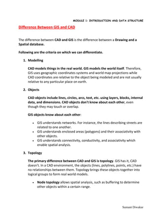
1. MODULE 1: INTRODUCTION AND DATA STRUCTURE
Difference Between GIS and CAD
The difference between CAD and GIS is the difference between a Drawing and a
Spatial database.
Following are the criteria on which we can differentiate.
1. Modelling
CAD models things in the real world. GIS models the world itself. Therefore,
GIS uses geographic coordinates systems and world map projections while
CAD coordinates are relative to the object being modeled and are not usually
relative to any particular place on earth.
2. Objects
CAD objects include lines, circles, arcs, text, etc. using layers, blocks, internal
data, and dimensions. CAD objects don't know about each other, even
though they may touch or overlap.
GIS objects know about each other:
• GIS understands networks. For instance, the lines describing streets are
related to one another.
• GIS understands enclosed areas (polygons) and their associativity with
other objects.
• GIS understands connectivity, conductivity, and associativity which
enable spatial analysis.
3. Topology
The primary difference between CAD and GIS is topology. GIS has it, CAD
doesn't. In a CAD environment, the objects (lines, polylines, points, etc.) have
no relationships between them. Topology brings these objects together into
logical groups to form real world models.
• Node topology allows spatial analysis, such as buffering to determine
other objects within a certain range.
Sumant Diwakar
2. MODULE 1: INTRODUCTION AND DATA STRUCTURE
• Network topology allows modeling of direction and resistance. Path
tracing finds the fastest or best route. Flood tracing determines the
maximum flow from a given point and network resistance. As with node
topology, buffer analysis can be applied to networks too.
• Polygon topology enables polygons to have relationships. Polygons also
have centroids which can be used to hold data relevant to the polygons.
Polygon spatial analysis includes overlay analysis such as determining
parcels in a floodplain. Polygons can be "dissolved" using attributes
with common values to remove interior lines, in effect aggregating
polygons within the same class.
Topology and spatial analysis differentiate GIS from CAD.
4. Data Management
GIS separates object storage from object display, combining data from
multiple sources into a virtual data warehouse. That data can then be used in
any number of separately defined analyses or presentations. CAD systems
carry baggage such as line color, line width, etc. that is not relevant to the
data itself.
GIS systems are usually disk-based and can model larger areas than CAD
implementations which are usually memory-based. For instance, CAD files are
typically smaller, such as product designs as compared to regional, state, or
even world models in GIS.
5. The Trend
While the distinction between CAD and GIS is grey now, as features are added
to CAD systems, the distinction will blur even more. and construction, GIS for
initial planning and lay-out.
Sumant Diwakar
3. MODULE 1: INTRODUCTION AND DATA STRUCTURE
Table summarizes the main differences.
CAD GIS
Mathematical Description Single complex objects in Large numbers of objects
3D (e.g., free form curved in a common embedding
surfaces) with high
accuracy
Coordinate System 2D and 3D orthogonal Many different coordinate
world systems model the
spherical (ellipsoid or
geoids) world
Coverage Small Areas Large Area (the whole
Earth)
Representation Mainly 3D Mainly 2D
Timescale Project basis (lifecycle Very long period of data
maintenance is a fairly collection and
recent issue) maintenance (almost an
endless lifecycle)
Sumant Diwakar