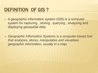
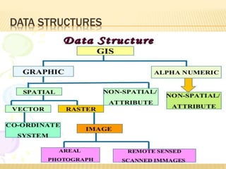
A Geographic Information System (GIS) is a computer system designed for capturing, storing, analyzing, and displaying geospatial data, comprising five main components: hardware, software, data, people, and methods. It enables users to manipulate geographic information through various functions such as data capture, compilation, storage, manipulation, and analysis, all using vector or raster data models. GIS has diverse applications, including mapping, urban planning, disaster management, and environmental analysis.

![ATTRIBUTE DATA TYPES
Categorical (name):
nominal
no inherent ordering
land use types, county names
ordinal
inherent order
road class; stream class
often coded to numbers eg SSN but can’t do arithmetic
Numerical
Known difference between values
interval
No natural zero
can’t say ‘twice as much’
temperature (Celsius or Fahrenheit)
ratio
natural zero
ratios make sense (e.g. twice as much)
income, age, rainfall
may be expressed as integer [whole number] or floating point [decimal
fraction]](https://image.slidesharecdn.com/geographicinformationsystem-180406190157/85/Geographic-information-system-18-320.jpg)

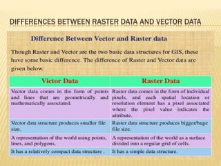
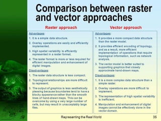
![RASTER DATA MODEL & RASTER DATA MODEL:
o Vector data model: Vector data models are useful for storing data that
has discrete boundaries, such as country borders, land parcels, and
streets.
best for features with discrete boundaries
property lines
political boundaries
transportation
o raster data model: [data models] A representation of the world
as a surface divided into a regular grid of cells.
attribute is represented as a single value for that cell
best for continuous features:
elevation
temperature
soil type
land use](https://image.slidesharecdn.com/geographicinformationsystem-180406190157/85/Geographic-information-system-20-320.jpg)