SlideShare a Scribd company logo
Sensors and Their Specifications


Thematic Mapper (TM)
       A Thematic Mapper (TM) is one of the Earth observing sensors introduced
       in the Landsat program. The first was placed aboard Landsat
       4 (decommissioned in 2001), and another was operational aboard Landsat
       5 up to 2012. TM sensors feature seven bands of image data (three in
       visible wavelengths, four in infrared) most of which have 30 meter spatial
       resolution. TM is a whisk broom scanner which takes multi-spectral
       images across its ground track. It does not directly produce a thematic map.
       The Thematic Mapper has become a useful tool in the study of albedo and
       its relationship to global warming and climate change.


Band Specification

        Band         Wavelength      Resolution    Swath        Revisit time
                       (µm)             (m)        Width          (days)
                                                    (km)
   Band 1 (Blue)      0.45 to 0.52       30          185             16
    Band 2 (Gr)       0.52 to 0.6        30          185             16
   Band 3 (Red)       0.63 to 0.69       30          185             16
   Band 4 (NIR)       0.76 to 0.9        30          185             16
  Band 5 (SWIR)       1.55 to 1.75       30          185             16
   Band 6 (TIR)       10.4 to 12.5      120          185             16
      Band 7          2.08 to 2.35
                                         30          185             16
      (SWIR)


S K Diwakar
Sensors and Their Specifications


Enhanced Thematic Mapper (ETM+)

       ETM+ is similar to TM, but has a higher spatial resolution thermal channel
       and includes a new panchromatic channel. These satellites have a polar,
       circular, sun-synchronous 705-km orbit with a 16-day repeat cycle. The TM
       swath width is 185 km.

Band Specification


              Band             Wavelength Region (µm)        Resolution (m)

               1                   0.450-0.515 (blue)              30

               2                   0.525-0.605 (green)             30

               3                    0.630-0.690 (red)              30

               4                0.750-0.900 (near-IR)              30

               5                   1.55-1.75 (mid-IR)              30

               6                10.4-12.5 (thermal-IR)             60

               7                   2.08-2.35 (mid-IR)              30

              PAN                      0.52-0.90                   15


S K Diwakar

More Related Content

What's hot

Sensors for remote sensing
Sensors for remote sensingSensors for remote sensing
Sensors for remote sensing
Mohsin Siddique
 
datum
datumdatum
datum
Riya Gupta
 
Thermal remote sensing
Thermal remote sensing   Thermal remote sensing
Thermal remote sensing
Rahat Malik
 
Digital Elevation Models
Digital Elevation ModelsDigital Elevation Models
Digital Elevation Models
Bernd Flmla
 
Thermal remote sensing and its applications
Thermal remote sensing and its applicationsThermal remote sensing and its applications
Thermal remote sensing and its applications
chandan00781
 
Basic remote sensing and gis
Basic remote sensing and gisBasic remote sensing and gis
Basic remote sensing and gis
SatGur Masters Academy
 
Remote sensing
Remote sensingRemote sensing
Remote sensingGokul Saud
 
Movement of EMR in the Atmosphere and Atmospheric window
Movement of EMR in the Atmosphere and Atmospheric windowMovement of EMR in the Atmosphere and Atmospheric window
Movement of EMR in the Atmosphere and Atmospheric window
Sumo Ranjan Mandal
 
Concept of gps
Concept of gpsConcept of gps
Concept of gps
Salauddin Rubel
 
Introduction of gps global navigation satellite systems
Introduction of gps   global navigation satellite systems Introduction of gps   global navigation satellite systems
Introduction of gps global navigation satellite systems DocumentStory
 
hyperspectral remote sensing and its geological applications
hyperspectral remote sensing and its geological applicationshyperspectral remote sensing and its geological applications
hyperspectral remote sensing and its geological applications
abhijeet_banerjee
 
Ems interaction with the atmosphere
Ems  interaction with the atmosphereEms  interaction with the atmosphere
Ems interaction with the atmosphere
Sk Abdullah
 
Commonly used ground truth equipments
Commonly used ground truth equipmentsCommonly used ground truth equipments
Commonly used ground truth equipments
HimangshuKalita10
 
Remote Sensing - Fundamentals
Remote Sensing - FundamentalsRemote Sensing - Fundamentals
Remote Sensing - Fundamentals
Ajay Singh Lodhi
 
spatial resolutionin remote sensing
 spatial resolutionin remote sensing spatial resolutionin remote sensing
spatial resolutionin remote sensing
Ghassan Hadi
 
Chapter 1 (Introduction to remote sensing)
Chapter 1 (Introduction to remote sensing)Chapter 1 (Introduction to remote sensing)
Chapter 1 (Introduction to remote sensing)
Shankar Gangaju
 
Spectral signatures
Spectral signaturesSpectral signatures
Spectral signatures
Kunal Rathod
 
Thermal Remote Sensing
Thermal Remote SensingThermal Remote Sensing
Thermal Remote Sensing
Rohit Kumar
 

What's hot (20)

Sensors for remote sensing
Sensors for remote sensingSensors for remote sensing
Sensors for remote sensing
 
datum
datumdatum
datum
 
LISS
LISSLISS
LISS
 
Thermal remote sensing
Thermal remote sensing   Thermal remote sensing
Thermal remote sensing
 
Digital Elevation Models
Digital Elevation ModelsDigital Elevation Models
Digital Elevation Models
 
Thermal remote sensing and its applications
Thermal remote sensing and its applicationsThermal remote sensing and its applications
Thermal remote sensing and its applications
 
Basic remote sensing and gis
Basic remote sensing and gisBasic remote sensing and gis
Basic remote sensing and gis
 
Remote sensing
Remote sensingRemote sensing
Remote sensing
 
SPOT
SPOTSPOT
SPOT
 
Movement of EMR in the Atmosphere and Atmospheric window
Movement of EMR in the Atmosphere and Atmospheric windowMovement of EMR in the Atmosphere and Atmospheric window
Movement of EMR in the Atmosphere and Atmospheric window
 
Concept of gps
Concept of gpsConcept of gps
Concept of gps
 
Introduction of gps global navigation satellite systems
Introduction of gps   global navigation satellite systems Introduction of gps   global navigation satellite systems
Introduction of gps global navigation satellite systems
 
hyperspectral remote sensing and its geological applications
hyperspectral remote sensing and its geological applicationshyperspectral remote sensing and its geological applications
hyperspectral remote sensing and its geological applications
 
Ems interaction with the atmosphere
Ems  interaction with the atmosphereEms  interaction with the atmosphere
Ems interaction with the atmosphere
 
Commonly used ground truth equipments
Commonly used ground truth equipmentsCommonly used ground truth equipments
Commonly used ground truth equipments
 
Remote Sensing - Fundamentals
Remote Sensing - FundamentalsRemote Sensing - Fundamentals
Remote Sensing - Fundamentals
 
spatial resolutionin remote sensing
 spatial resolutionin remote sensing spatial resolutionin remote sensing
spatial resolutionin remote sensing
 
Chapter 1 (Introduction to remote sensing)
Chapter 1 (Introduction to remote sensing)Chapter 1 (Introduction to remote sensing)
Chapter 1 (Introduction to remote sensing)
 
Spectral signatures
Spectral signaturesSpectral signatures
Spectral signatures
 
Thermal Remote Sensing
Thermal Remote SensingThermal Remote Sensing
Thermal Remote Sensing
 

Similar to Thematic mapper

Introduction to Landsat
Introduction to LandsatIntroduction to Landsat
Introduction to Landsat
Nizam GIS
 
1Resolutions of Remote Sensing1. Spatial (what area an.docx
1Resolutions of Remote Sensing1. Spatial (what area an.docx1Resolutions of Remote Sensing1. Spatial (what area an.docx
1Resolutions of Remote Sensing1. Spatial (what area an.docx
aulasnilda
 
Platforms of Remote sensing and GIS
Platforms of Remote sensing and GISPlatforms of Remote sensing and GIS
Platforms of Remote sensing and GIS
Mouna Guru
 
Remote sensing satellites with sensors
Remote sensing satellites with sensorsRemote sensing satellites with sensors
Remote sensing satellites with sensors
Anchit Garg
 
Lrm 111 intro remote sensing lesson iv
Lrm 111 intro remote sensing lesson ivLrm 111 intro remote sensing lesson iv
Lrm 111 intro remote sensing lesson iv
musadoto
 
nisizawa_IGARSS_HSRL_FR2.T07.ppt
nisizawa_IGARSS_HSRL_FR2.T07.pptnisizawa_IGARSS_HSRL_FR2.T07.ppt
nisizawa_IGARSS_HSRL_FR2.T07.pptgrssieee
 
Sareic mauger
Sareic maugerSareic mauger
Sareic mauger
Brett Johnson
 
Polarimetric Study of emission nebulea Stock 8 in Auriga
Polarimetric Study of emission nebulea Stock 8 in AurigaPolarimetric Study of emission nebulea Stock 8 in Auriga
Polarimetric Study of emission nebulea Stock 8 in Aurigarahulporuri
 
CROSS-COMPARISON BETWEEN CHINA HJ1A-CCD AND LANDSAT TM DATA(Guoqing Li).ppt
CROSS-COMPARISON BETWEEN CHINA HJ1A-CCD AND LANDSAT TM DATA(Guoqing Li).pptCROSS-COMPARISON BETWEEN CHINA HJ1A-CCD AND LANDSAT TM DATA(Guoqing Li).ppt
CROSS-COMPARISON BETWEEN CHINA HJ1A-CCD AND LANDSAT TM DATA(Guoqing Li).pptgrssieee
 
Remote Sensing - Operating Satellites
Remote Sensing -  Operating SatellitesRemote Sensing -  Operating Satellites
Remote Sensing - Operating Satellites
Ahmed Nassar
 
Spectral data fusion for quantitative assessment of soils from Brazil, Dr. Fa...
Spectral data fusion for quantitative assessment of soils from Brazil, Dr. Fa...Spectral data fusion for quantitative assessment of soils from Brazil, Dr. Fa...
Spectral data fusion for quantitative assessment of soils from Brazil, Dr. Fa...
FAO
 
03 Landsat Legacy.pptx
03 Landsat Legacy.pptx03 Landsat Legacy.pptx
03 Landsat Legacy.pptx
HrudayKumar8
 
Presentation on the background theory of InSAR
Presentation on the background theory of InSARPresentation on the background theory of InSAR
Presentation on the background theory of InSAR
SERC at Carleton College
 
Remote sensing and image interpretation
Remote sensing and image interpretationRemote sensing and image interpretation
Remote sensing and image interpretation
Md. Nazir Hossain
 
Innelastic Light Scattering in Carbon Nanostructures: from the micro to the n...
Innelastic Light Scattering in Carbon Nanostructures: from the micro to the n...Innelastic Light Scattering in Carbon Nanostructures: from the micro to the n...
Innelastic Light Scattering in Carbon Nanostructures: from the micro to the n...
Sociedade Brasileira de Pesquisa em Materiais
 

Similar to Thematic mapper (20)

Introduction to Landsat
Introduction to LandsatIntroduction to Landsat
Introduction to Landsat
 
1Resolutions of Remote Sensing1. Spatial (what area an.docx
1Resolutions of Remote Sensing1. Spatial (what area an.docx1Resolutions of Remote Sensing1. Spatial (what area an.docx
1Resolutions of Remote Sensing1. Spatial (what area an.docx
 
Platforms of Remote sensing and GIS
Platforms of Remote sensing and GISPlatforms of Remote sensing and GIS
Platforms of Remote sensing and GIS
 
Remote sensing satellites with sensors
Remote sensing satellites with sensorsRemote sensing satellites with sensors
Remote sensing satellites with sensors
 
Lrm 111 intro remote sensing lesson iv
Lrm 111 intro remote sensing lesson ivLrm 111 intro remote sensing lesson iv
Lrm 111 intro remote sensing lesson iv
 
nisizawa_IGARSS_HSRL_FR2.T07.ppt
nisizawa_IGARSS_HSRL_FR2.T07.pptnisizawa_IGARSS_HSRL_FR2.T07.ppt
nisizawa_IGARSS_HSRL_FR2.T07.ppt
 
MODIS
MODISMODIS
MODIS
 
Sareic mauger
Sareic maugerSareic mauger
Sareic mauger
 
Iirs rstechnologypdf
Iirs rstechnologypdfIirs rstechnologypdf
Iirs rstechnologypdf
 
;
;;
;
 
Polarimetric Study of emission nebulea Stock 8 in Auriga
Polarimetric Study of emission nebulea Stock 8 in AurigaPolarimetric Study of emission nebulea Stock 8 in Auriga
Polarimetric Study of emission nebulea Stock 8 in Auriga
 
CROSS-COMPARISON BETWEEN CHINA HJ1A-CCD AND LANDSAT TM DATA(Guoqing Li).ppt
CROSS-COMPARISON BETWEEN CHINA HJ1A-CCD AND LANDSAT TM DATA(Guoqing Li).pptCROSS-COMPARISON BETWEEN CHINA HJ1A-CCD AND LANDSAT TM DATA(Guoqing Li).ppt
CROSS-COMPARISON BETWEEN CHINA HJ1A-CCD AND LANDSAT TM DATA(Guoqing Li).ppt
 
CROSS-COMPARISON BETWEEN CHINA HJ1A-CCD AND LANDSAT TM DATA(Guoqing Li).ppt
CROSS-COMPARISON BETWEEN CHINA HJ1A-CCD AND LANDSAT TM DATA(Guoqing Li).pptCROSS-COMPARISON BETWEEN CHINA HJ1A-CCD AND LANDSAT TM DATA(Guoqing Li).ppt
CROSS-COMPARISON BETWEEN CHINA HJ1A-CCD AND LANDSAT TM DATA(Guoqing Li).ppt
 
Remote Sensing - Operating Satellites
Remote Sensing -  Operating SatellitesRemote Sensing -  Operating Satellites
Remote Sensing - Operating Satellites
 
Spectral data fusion for quantitative assessment of soils from Brazil, Dr. Fa...
Spectral data fusion for quantitative assessment of soils from Brazil, Dr. Fa...Spectral data fusion for quantitative assessment of soils from Brazil, Dr. Fa...
Spectral data fusion for quantitative assessment of soils from Brazil, Dr. Fa...
 
Aa19213 12
Aa19213 12Aa19213 12
Aa19213 12
 
03 Landsat Legacy.pptx
03 Landsat Legacy.pptx03 Landsat Legacy.pptx
03 Landsat Legacy.pptx
 
Presentation on the background theory of InSAR
Presentation on the background theory of InSARPresentation on the background theory of InSAR
Presentation on the background theory of InSAR
 
Remote sensing and image interpretation
Remote sensing and image interpretationRemote sensing and image interpretation
Remote sensing and image interpretation
 
Innelastic Light Scattering in Carbon Nanostructures: from the micro to the n...
Innelastic Light Scattering in Carbon Nanostructures: from the micro to the n...Innelastic Light Scattering in Carbon Nanostructures: from the micro to the n...
Innelastic Light Scattering in Carbon Nanostructures: from the micro to the n...
 

More from Sumant Diwakar

Hydrologic Assessment in a Middle Narmada Basin, India using SWAT Model
Hydrologic Assessment in a Middle Narmada Basin, India using SWAT ModelHydrologic Assessment in a Middle Narmada Basin, India using SWAT Model
Hydrologic Assessment in a Middle Narmada Basin, India using SWAT Model
Sumant Diwakar
 
C Programming
C ProgrammingC Programming
C Programming
Sumant Diwakar
 
C Programming
C ProgrammingC Programming
C Programming
Sumant Diwakar
 
Soil moisture
Soil moistureSoil moisture
Soil moisture
Sumant Diwakar
 
REMOTE SENSING & GIS APPLICATIONS IN WATERSHED MANAGEMENT
REMOTE SENSING & GIS APPLICATIONS IN WATERSHED MANAGEMENT REMOTE SENSING & GIS APPLICATIONS IN WATERSHED MANAGEMENT
REMOTE SENSING & GIS APPLICATIONS IN WATERSHED MANAGEMENT
Sumant Diwakar
 
Relation between Ground-based Soil Moisture and Satellite Image-based NDVI
Relation between Ground-based Soil Moisture and Satellite Image-based NDVIRelation between Ground-based Soil Moisture and Satellite Image-based NDVI
Relation between Ground-based Soil Moisture and Satellite Image-based NDVI
Sumant Diwakar
 
Solar irradiation & spectral signature
Solar irradiation & spectral signatureSolar irradiation & spectral signature
Solar irradiation & spectral signatureSumant Diwakar
 
Optical remote sensing
Optical remote sensingOptical remote sensing
Optical remote sensingSumant Diwakar
 
Interaction of EMR with atmosphere and earth surface
Interaction of EMR with atmosphere and earth surfaceInteraction of EMR with atmosphere and earth surface
Interaction of EMR with atmosphere and earth surfaceSumant Diwakar
 
History of remote sensing
History of remote sensingHistory of remote sensing
History of remote sensingSumant Diwakar
 
Electromagnetic radiation
Electromagnetic radiationElectromagnetic radiation
Electromagnetic radiationSumant Diwakar
 
Differential gps (dgps) 09 04-12
Differential gps (dgps) 09 04-12Differential gps (dgps) 09 04-12
Differential gps (dgps) 09 04-12Sumant Diwakar
 
Principle of photogrammetry
Principle of photogrammetryPrinciple of photogrammetry
Principle of photogrammetrySumant Diwakar
 
Automatic digital terrain modelling
Automatic digital terrain modellingAutomatic digital terrain modelling
Automatic digital terrain modellingSumant Diwakar
 
Aerial photography abraham thomas
Aerial photography abraham thomasAerial photography abraham thomas
Aerial photography abraham thomasSumant Diwakar
 
Aerial photographs and their interpretation
Aerial photographs and their interpretationAerial photographs and their interpretation
Aerial photographs and their interpretationSumant Diwakar
 

More from Sumant Diwakar (20)

Hydrologic Assessment in a Middle Narmada Basin, India using SWAT Model
Hydrologic Assessment in a Middle Narmada Basin, India using SWAT ModelHydrologic Assessment in a Middle Narmada Basin, India using SWAT Model
Hydrologic Assessment in a Middle Narmada Basin, India using SWAT Model
 
C Programming
C ProgrammingC Programming
C Programming
 
C Programming
C ProgrammingC Programming
C Programming
 
Soil moisture
Soil moistureSoil moisture
Soil moisture
 
REMOTE SENSING & GIS APPLICATIONS IN WATERSHED MANAGEMENT
REMOTE SENSING & GIS APPLICATIONS IN WATERSHED MANAGEMENT REMOTE SENSING & GIS APPLICATIONS IN WATERSHED MANAGEMENT
REMOTE SENSING & GIS APPLICATIONS IN WATERSHED MANAGEMENT
 
Relation between Ground-based Soil Moisture and Satellite Image-based NDVI
Relation between Ground-based Soil Moisture and Satellite Image-based NDVIRelation between Ground-based Soil Moisture and Satellite Image-based NDVI
Relation between Ground-based Soil Moisture and Satellite Image-based NDVI
 
Solar irradiation & spectral signature
Solar irradiation & spectral signatureSolar irradiation & spectral signature
Solar irradiation & spectral signature
 
Optical remote sensing
Optical remote sensingOptical remote sensing
Optical remote sensing
 
Interaction of EMR with atmosphere and earth surface
Interaction of EMR with atmosphere and earth surfaceInteraction of EMR with atmosphere and earth surface
Interaction of EMR with atmosphere and earth surface
 
History of remote sensing
History of remote sensingHistory of remote sensing
History of remote sensing
 
Electromagnetic radiation
Electromagnetic radiationElectromagnetic radiation
Electromagnetic radiation
 
Map projection
Map projectionMap projection
Map projection
 
Differential gps (dgps) 09 04-12
Differential gps (dgps) 09 04-12Differential gps (dgps) 09 04-12
Differential gps (dgps) 09 04-12
 
Principle of photogrammetry
Principle of photogrammetryPrinciple of photogrammetry
Principle of photogrammetry
 
Digital terrain model
Digital terrain modelDigital terrain model
Digital terrain model
 
Digital orthophoto
Digital orthophotoDigital orthophoto
Digital orthophoto
 
Automatic digital terrain modelling
Automatic digital terrain modellingAutomatic digital terrain modelling
Automatic digital terrain modelling
 
Aerial photography abraham thomas
Aerial photography abraham thomasAerial photography abraham thomas
Aerial photography abraham thomas
 
Aerial photographs and their interpretation
Aerial photographs and their interpretationAerial photographs and their interpretation
Aerial photographs and their interpretation
 
Wide field sensor
Wide field sensorWide field sensor
Wide field sensor
 

Recently uploaded

Azure Interview Questions and Answers PDF By ScholarHat
Azure Interview Questions and Answers PDF By ScholarHatAzure Interview Questions and Answers PDF By ScholarHat
Azure Interview Questions and Answers PDF By ScholarHat
Scholarhat
 
MASS MEDIA STUDIES-835-CLASS XI Resource Material.pdf
MASS MEDIA STUDIES-835-CLASS XI Resource Material.pdfMASS MEDIA STUDIES-835-CLASS XI Resource Material.pdf
MASS MEDIA STUDIES-835-CLASS XI Resource Material.pdf
goswamiyash170123
 
TESDA TM1 REVIEWER FOR NATIONAL ASSESSMENT WRITTEN AND ORAL QUESTIONS WITH A...
TESDA TM1 REVIEWER  FOR NATIONAL ASSESSMENT WRITTEN AND ORAL QUESTIONS WITH A...TESDA TM1 REVIEWER  FOR NATIONAL ASSESSMENT WRITTEN AND ORAL QUESTIONS WITH A...
TESDA TM1 REVIEWER FOR NATIONAL ASSESSMENT WRITTEN AND ORAL QUESTIONS WITH A...
EugeneSaldivar
 
CACJapan - GROUP Presentation 1- Wk 4.pdf
CACJapan - GROUP Presentation 1- Wk 4.pdfCACJapan - GROUP Presentation 1- Wk 4.pdf
CACJapan - GROUP Presentation 1- Wk 4.pdf
camakaiclarkmusic
 
Digital Artifact 2 - Investigating Pavilion Designs
Digital Artifact 2 - Investigating Pavilion DesignsDigital Artifact 2 - Investigating Pavilion Designs
Digital Artifact 2 - Investigating Pavilion Designs
chanes7
 
BÀI TẬP BỔ TRỢ TIẾNG ANH GLOBAL SUCCESS LỚP 3 - CẢ NĂM (CÓ FILE NGHE VÀ ĐÁP Á...
BÀI TẬP BỔ TRỢ TIẾNG ANH GLOBAL SUCCESS LỚP 3 - CẢ NĂM (CÓ FILE NGHE VÀ ĐÁP Á...BÀI TẬP BỔ TRỢ TIẾNG ANH GLOBAL SUCCESS LỚP 3 - CẢ NĂM (CÓ FILE NGHE VÀ ĐÁP Á...
BÀI TẬP BỔ TRỢ TIẾNG ANH GLOBAL SUCCESS LỚP 3 - CẢ NĂM (CÓ FILE NGHE VÀ ĐÁP Á...
Nguyen Thanh Tu Collection
 
Normal Labour/ Stages of Labour/ Mechanism of Labour
Normal Labour/ Stages of Labour/ Mechanism of LabourNormal Labour/ Stages of Labour/ Mechanism of Labour
Normal Labour/ Stages of Labour/ Mechanism of Labour
Wasim Ak
 
Unit 8 - Information and Communication Technology (Paper I).pdf
Unit 8 - Information and Communication Technology (Paper I).pdfUnit 8 - Information and Communication Technology (Paper I).pdf
Unit 8 - Information and Communication Technology (Paper I).pdf
Thiyagu K
 
Lapbook sobre os Regimes Totalitários.pdf
Lapbook sobre os Regimes Totalitários.pdfLapbook sobre os Regimes Totalitários.pdf
Lapbook sobre os Regimes Totalitários.pdf
Jean Carlos Nunes Paixão
 
Acetabularia Information For Class 9 .docx
Acetabularia Information For Class 9  .docxAcetabularia Information For Class 9  .docx
Acetabularia Information For Class 9 .docx
vaibhavrinwa19
 
A Survey of Techniques for Maximizing LLM Performance.pptx
A Survey of Techniques for Maximizing LLM Performance.pptxA Survey of Techniques for Maximizing LLM Performance.pptx
A Survey of Techniques for Maximizing LLM Performance.pptx
thanhdowork
 
June 3, 2024 Anti-Semitism Letter Sent to MIT President Kornbluth and MIT Cor...
June 3, 2024 Anti-Semitism Letter Sent to MIT President Kornbluth and MIT Cor...June 3, 2024 Anti-Semitism Letter Sent to MIT President Kornbluth and MIT Cor...
June 3, 2024 Anti-Semitism Letter Sent to MIT President Kornbluth and MIT Cor...
Levi Shapiro
 
Supporting (UKRI) OA monographs at Salford.pptx
Supporting (UKRI) OA monographs at Salford.pptxSupporting (UKRI) OA monographs at Salford.pptx
Supporting (UKRI) OA monographs at Salford.pptx
Jisc
 
Biological Screening of Herbal Drugs in detailed.
Biological Screening of Herbal Drugs in detailed.Biological Screening of Herbal Drugs in detailed.
Biological Screening of Herbal Drugs in detailed.
Ashokrao Mane college of Pharmacy Peth-Vadgaon
 
Chapter 3 - Islamic Banking Products and Services.pptx
Chapter 3 - Islamic Banking Products and Services.pptxChapter 3 - Islamic Banking Products and Services.pptx
Chapter 3 - Islamic Banking Products and Services.pptx
Mohd Adib Abd Muin, Senior Lecturer at Universiti Utara Malaysia
 
Thesis Statement for students diagnonsed withADHD.ppt
Thesis Statement for students diagnonsed withADHD.pptThesis Statement for students diagnonsed withADHD.ppt
Thesis Statement for students diagnonsed withADHD.ppt
EverAndrsGuerraGuerr
 
Executive Directors Chat Leveraging AI for Diversity, Equity, and Inclusion
Executive Directors Chat  Leveraging AI for Diversity, Equity, and InclusionExecutive Directors Chat  Leveraging AI for Diversity, Equity, and Inclusion
Executive Directors Chat Leveraging AI for Diversity, Equity, and Inclusion
TechSoup
 
JEE1_This_section_contains_FOUR_ questions
JEE1_This_section_contains_FOUR_ questionsJEE1_This_section_contains_FOUR_ questions
JEE1_This_section_contains_FOUR_ questions
ShivajiThube2
 
Model Attribute Check Company Auto Property
Model Attribute  Check Company Auto PropertyModel Attribute  Check Company Auto Property
Model Attribute Check Company Auto Property
Celine George
 
Operation Blue Star - Saka Neela Tara
Operation Blue Star   -  Saka Neela TaraOperation Blue Star   -  Saka Neela Tara
Operation Blue Star - Saka Neela Tara
Balvir Singh
 

Recently uploaded (20)

Azure Interview Questions and Answers PDF By ScholarHat
Azure Interview Questions and Answers PDF By ScholarHatAzure Interview Questions and Answers PDF By ScholarHat
Azure Interview Questions and Answers PDF By ScholarHat
 
MASS MEDIA STUDIES-835-CLASS XI Resource Material.pdf
MASS MEDIA STUDIES-835-CLASS XI Resource Material.pdfMASS MEDIA STUDIES-835-CLASS XI Resource Material.pdf
MASS MEDIA STUDIES-835-CLASS XI Resource Material.pdf
 
TESDA TM1 REVIEWER FOR NATIONAL ASSESSMENT WRITTEN AND ORAL QUESTIONS WITH A...
TESDA TM1 REVIEWER  FOR NATIONAL ASSESSMENT WRITTEN AND ORAL QUESTIONS WITH A...TESDA TM1 REVIEWER  FOR NATIONAL ASSESSMENT WRITTEN AND ORAL QUESTIONS WITH A...
TESDA TM1 REVIEWER FOR NATIONAL ASSESSMENT WRITTEN AND ORAL QUESTIONS WITH A...
 
CACJapan - GROUP Presentation 1- Wk 4.pdf
CACJapan - GROUP Presentation 1- Wk 4.pdfCACJapan - GROUP Presentation 1- Wk 4.pdf
CACJapan - GROUP Presentation 1- Wk 4.pdf
 
Digital Artifact 2 - Investigating Pavilion Designs
Digital Artifact 2 - Investigating Pavilion DesignsDigital Artifact 2 - Investigating Pavilion Designs
Digital Artifact 2 - Investigating Pavilion Designs
 
BÀI TẬP BỔ TRỢ TIẾNG ANH GLOBAL SUCCESS LỚP 3 - CẢ NĂM (CÓ FILE NGHE VÀ ĐÁP Á...
BÀI TẬP BỔ TRỢ TIẾNG ANH GLOBAL SUCCESS LỚP 3 - CẢ NĂM (CÓ FILE NGHE VÀ ĐÁP Á...BÀI TẬP BỔ TRỢ TIẾNG ANH GLOBAL SUCCESS LỚP 3 - CẢ NĂM (CÓ FILE NGHE VÀ ĐÁP Á...
BÀI TẬP BỔ TRỢ TIẾNG ANH GLOBAL SUCCESS LỚP 3 - CẢ NĂM (CÓ FILE NGHE VÀ ĐÁP Á...
 
Normal Labour/ Stages of Labour/ Mechanism of Labour
Normal Labour/ Stages of Labour/ Mechanism of LabourNormal Labour/ Stages of Labour/ Mechanism of Labour
Normal Labour/ Stages of Labour/ Mechanism of Labour
 
Unit 8 - Information and Communication Technology (Paper I).pdf
Unit 8 - Information and Communication Technology (Paper I).pdfUnit 8 - Information and Communication Technology (Paper I).pdf
Unit 8 - Information and Communication Technology (Paper I).pdf
 
Lapbook sobre os Regimes Totalitários.pdf
Lapbook sobre os Regimes Totalitários.pdfLapbook sobre os Regimes Totalitários.pdf
Lapbook sobre os Regimes Totalitários.pdf
 
Acetabularia Information For Class 9 .docx
Acetabularia Information For Class 9  .docxAcetabularia Information For Class 9  .docx
Acetabularia Information For Class 9 .docx
 
A Survey of Techniques for Maximizing LLM Performance.pptx
A Survey of Techniques for Maximizing LLM Performance.pptxA Survey of Techniques for Maximizing LLM Performance.pptx
A Survey of Techniques for Maximizing LLM Performance.pptx
 
June 3, 2024 Anti-Semitism Letter Sent to MIT President Kornbluth and MIT Cor...
June 3, 2024 Anti-Semitism Letter Sent to MIT President Kornbluth and MIT Cor...June 3, 2024 Anti-Semitism Letter Sent to MIT President Kornbluth and MIT Cor...
June 3, 2024 Anti-Semitism Letter Sent to MIT President Kornbluth and MIT Cor...
 
Supporting (UKRI) OA monographs at Salford.pptx
Supporting (UKRI) OA monographs at Salford.pptxSupporting (UKRI) OA monographs at Salford.pptx
Supporting (UKRI) OA monographs at Salford.pptx
 
Biological Screening of Herbal Drugs in detailed.
Biological Screening of Herbal Drugs in detailed.Biological Screening of Herbal Drugs in detailed.
Biological Screening of Herbal Drugs in detailed.
 
Chapter 3 - Islamic Banking Products and Services.pptx
Chapter 3 - Islamic Banking Products and Services.pptxChapter 3 - Islamic Banking Products and Services.pptx
Chapter 3 - Islamic Banking Products and Services.pptx
 
Thesis Statement for students diagnonsed withADHD.ppt
Thesis Statement for students diagnonsed withADHD.pptThesis Statement for students diagnonsed withADHD.ppt
Thesis Statement for students diagnonsed withADHD.ppt
 
Executive Directors Chat Leveraging AI for Diversity, Equity, and Inclusion
Executive Directors Chat  Leveraging AI for Diversity, Equity, and InclusionExecutive Directors Chat  Leveraging AI for Diversity, Equity, and Inclusion
Executive Directors Chat Leveraging AI for Diversity, Equity, and Inclusion
 
JEE1_This_section_contains_FOUR_ questions
JEE1_This_section_contains_FOUR_ questionsJEE1_This_section_contains_FOUR_ questions
JEE1_This_section_contains_FOUR_ questions
 
Model Attribute Check Company Auto Property
Model Attribute  Check Company Auto PropertyModel Attribute  Check Company Auto Property
Model Attribute Check Company Auto Property
 
Operation Blue Star - Saka Neela Tara
Operation Blue Star   -  Saka Neela TaraOperation Blue Star   -  Saka Neela Tara
Operation Blue Star - Saka Neela Tara
 

Thematic mapper

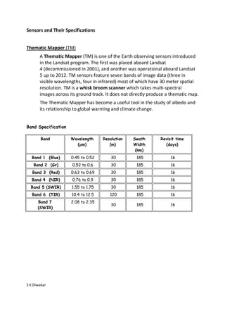
  • 1. Sensors and Their Specifications Thematic Mapper (TM) A Thematic Mapper (TM) is one of the Earth observing sensors introduced in the Landsat program. The first was placed aboard Landsat 4 (decommissioned in 2001), and another was operational aboard Landsat 5 up to 2012. TM sensors feature seven bands of image data (three in visible wavelengths, four in infrared) most of which have 30 meter spatial resolution. TM is a whisk broom scanner which takes multi-spectral images across its ground track. It does not directly produce a thematic map. The Thematic Mapper has become a useful tool in the study of albedo and its relationship to global warming and climate change. Band Specification Band Wavelength Resolution Swath Revisit time (µm) (m) Width (days) (km) Band 1 (Blue) 0.45 to 0.52 30 185 16 Band 2 (Gr) 0.52 to 0.6 30 185 16 Band 3 (Red) 0.63 to 0.69 30 185 16 Band 4 (NIR) 0.76 to 0.9 30 185 16 Band 5 (SWIR) 1.55 to 1.75 30 185 16 Band 6 (TIR) 10.4 to 12.5 120 185 16 Band 7 2.08 to 2.35 30 185 16 (SWIR) S K Diwakar
  • 2. Sensors and Their Specifications Enhanced Thematic Mapper (ETM+) ETM+ is similar to TM, but has a higher spatial resolution thermal channel and includes a new panchromatic channel. These satellites have a polar, circular, sun-synchronous 705-km orbit with a 16-day repeat cycle. The TM swath width is 185 km. Band Specification Band Wavelength Region (µm) Resolution (m) 1 0.450-0.515 (blue) 30 2 0.525-0.605 (green) 30 3 0.630-0.690 (red) 30 4 0.750-0.900 (near-IR) 30 5 1.55-1.75 (mid-IR) 30 6 10.4-12.5 (thermal-IR) 60 7 2.08-2.35 (mid-IR) 30 PAN 0.52-0.90 15 S K Diwakar