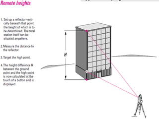
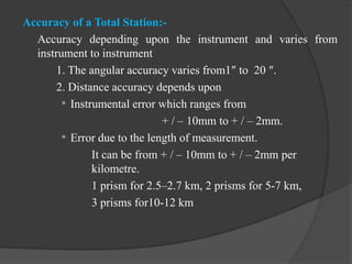
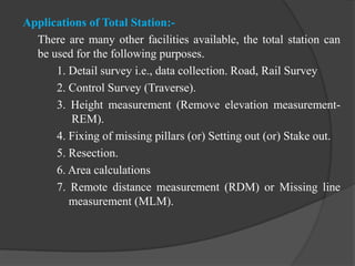
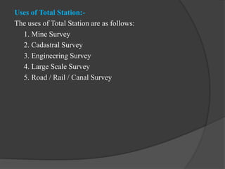
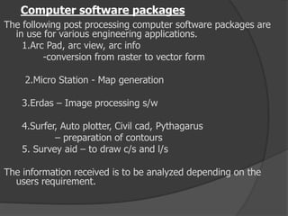
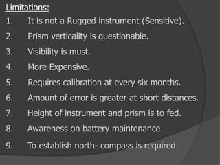
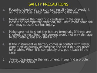
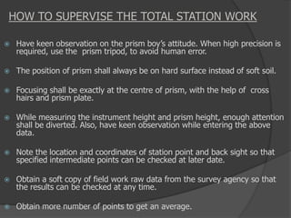
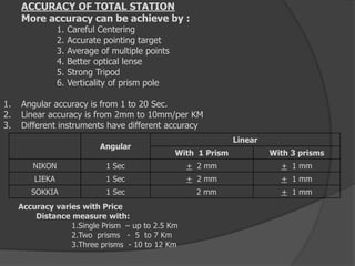
SlideShare a Scribd company logo
Department of Civil Engineering
GITS, Udaipur
Notes of Surveying Chapter 6 &
Surveying Lab
Topic- Total Station
Semester/ Year – 3/ 2
Exp.- 8
Aim:- To study the various electronic surveying instruments like
EDM, Total Station etc. What is Total station?
 A total station is an electronic/optical instrument used in
modern surveying and Building construction that uses
electronic transit theodolite in conjunction with electronic
distance meter (EDM).
 It is also integrated with microprocessor, electronic data
collector and storage system.
 The instrument is used to measure sloping distance of object
to the instrument, horizontal angles and vertical angles.
 This Microprocessor unit enables for computation of data
collected to further calculate the horizontal distance,
coordinates of a point and reduced level of point.
 Data collected from total station can be downloaded into
computer/laptops for further processing of information.
 Total stations are mainly used by land surveyors and civil
engineers, either to record features as in
topographic surveying or to set out features (such as roads,
houses or boundaries).
Total Station with Tripod stand & Reflector prism
Total station is a combination of :
EDM
Theodolite
Auto Leveler
Microprocessor with specific memory
Battery/spare
which works about 5 working hours
About 100 models were released till now by different firms.
Basic components of Total station
 Prism reflector:
It is a combination of ranging rod,
staff and optical cuboidal mirror. having
2/3 lifts with 5cms interval graduations.
adjustable height from 1.5m to 3.75m.
More number of prisms, will give more
accuracy.
Basic components of Total station
•GUN: data screen LCD
eye piece
telescope 24x to 43x
environmental box
microprocessor with memory card of 1 or 2 GB capacity
1MB can store 800 points.
•Tripod: with different material
Aluminum tripod weighs 13 to 14lbs
Wooden tripod will be about 18 lbs.
•Optical and Laser plumb bobs.
•Battery –as an external attachment
with indicators
1.5hours charged battery can work for 3to 5 hours
Setting up the total station over a ground point:-
1. Place the tripod approximately over the ground point.
2. Inspect the tripod from various sides and correct its position so
that the tripod plate is roughly horizontal and above the ground
point.
3. Push the tripod legs firmly into the ground and use the central
fixing screw to secure the instrument on the tripod.
4. Switch on the laser plummet (or, for older instruments, look
through the optical plummet) and turn the foot screws so that
the laser dot or the optical plummet is centred on the ground
point.
5. Centre the bull’s-eye bubble by adjusting the lengths of the
tripod legs
6. After accurately levelling up the instrument, release the central
fixing screw so that you can displace it on the tripod plate
until the laser dot is centred precisely over the ground point.
7. Tighten the central fixing screw again.
Accuracy of a Total Station:-
Accuracy depending upon the instrument and varies from
instrument to instrument
1. The angular accuracy varies from1″ to 20 ″.
2. Distance accuracy depends upon
 Instrumental error which ranges from
+ / – 10mm to + / – 2mm.
 Error due to the length of measurement.
It can be from + / – 10mm to + / – 2mm per
kilometre.
1 prism for 2.5–2.7 km, 2 prisms for 5-7 km,
3 prisms for10-12 km
Applications of Total Station:-
There are many other facilities available, the total station can
be used for the following purposes.
1. Detail survey i.e., data collection. Road, Rail Survey
2. Control Survey (Traverse).
3. Height measurement (Remove elevation measurement-
REM).
4. Fixing of missing pillars (or) Setting out (or) Stake out.
5. Resection.
6. Area calculations
7. Remote distance measurement (RDM) or Missing line
measurement (MLM).
Uses of Total Station:-
The uses of Total Station are as follows:
1. Mine Survey
2. Cadastral Survey
3. Engineering Survey
4. Large Scale Survey
5. Road / Rail / Canal Survey
Functions of T.S:
1. It simultaneously measures angles & distances and Record
2. Correcting the measured distance with:
1. Prism constant
2. Atmospheric Pr.
3. Temperature
4. Curvature of earth
5. Refraction correction
3. Computing the point elevation
4. Computing the coordinates of every point
5. Remote elevation measurement
6. Remote distance measurement
7. Area calculations
8. Data Transferring facility from instrument to S/W and S/W
to instrument
9. Format of conversion of units
REM
Remote Elevation Measurement
RDM
Remote Distance Measurement
karthik
Charchit
Yogesh Dainik
RDM
Remote Distance Measurement
Survey of Cricket Ground by Total Station
Operations involved while using Total Stations
:
1. Establishing the site Datum:
a) Selecting the site Datum
b) Establishing North
2. Setting up the Total station:
a) Placing and leveling Tripod on Datum
b) Placing and leveling the Gun on Tripod
c) Linking the data connector to Gun
3. Data collector options and setting
a) Main menu
b) Basic settings
4. Creating and Operating Job files:
a) Creating a new Job file
b) Opening an existing file
5. Shooting points
a) Identifying the important points to shoot
b) shooting points
c) Shooting additional points
d) Noting the special features
6.Post Processing – Data down loading,conversion
7.Plotting/Map generation.
Computer software packages
The following post processing computer software packages are
in use for various engineering applications.
1.Arc Pad, arc view, arc info
-conversion from raster to vector form
2.Micro Station - Map generation
3.Erdas – Image processing s/w
4.Surfer, Auto plotter, Civil cad, Pythagarus
– preparation of contours
5. Survey aid – to draw c/s and l/s
The information received is to be analyzed depending on the
users requirement.
Limitations:
1. It is not a Rugged instrument (Sensitive).
2. Prism verticality is questionable.
3. Visibility is must.
4. More Expensive.
5. Requires calibration at every six months.
6. Amount of error is greater at short distances.
7. Height of instrument and prism is to fed.
8. Awareness on battery maintenance.
9. To establish north- compass is required.
SAFETY PRECAUTIONS
1. Focusing directly at the sun, can result - loss of eyesight
on the spot. Use a filter when observing the sun.
2. Never remove the hand grip carelessly. If the grip is
loosely or incompletely attached, the instrument could fall
and may cause a serious injury.
3. Make sure not to short the battery terminals. If these are
shorted, the resulting high current would not only damage
to the battery, but also start a fire.
4. If the instrument or battery comes in contact with water,
wipe it off as quickly as possible and set it in a dry place
for a while. When it is completely dry, put it back in the
case.
5. Never disassemble the instrument, if you find a problem.
Contact the dealer.
HOW TO SUPERVISE THE TOTAL STATION WORK
 Have keen observation on the prism boy’s attitude. When high precision is
required, use the prism tripod, to avoid human error.
 The position of prism shall always be on hard surface instead of soft soil.
 Focusing shall be exactly at the centre of prism, with the help of cross
hairs and prism plate.
 While measuring the instrument height and prism height, enough attention
shall be diverted. Also, have keen observation while entering the above
data.
 Note the location and coordinates of station point and back sight so that
specified intermediate points can be checked at later date.
 Obtain a soft copy of field work raw data from the survey agency so that
the results can be checked at any time.
 Obtain more number of points to get an average.
ACCURACY OF TOTAL STATION
More accuracy can be achieve by :
1. Careful Centering
2. Accurate pointing target
3. Average of multiple points
4. Better optical lense
5. Strong Tripod
6. Verticality of prism pole
1. Angular accuracy is from 1 to 20 Sec.
2. Linear accuracy is from 2mm to 10mm/per KM
3. Different instruments have different accuracy
Angular
Linear
With 1 Prism With 3 prisms
NIKON 1 Sec + 2 mm + 1 mm
LIEKA 1 Sec + 2 mm + 1 mm
SOKKIA 1 Sec 2 mm + 1 mm
Accuracy varies with Price
Distance measure with:
1.Single Prism – up to 2.5 Km
2.Two prisms - 5 to 7 Km
3.Three prisms - 10 to 12 Km

More Related Content

Similar to Total Station by Denis Jangeed.pdf

MODERN SURVEYING TECHNIQUES.pptx
 MODERN SURVEYING TECHNIQUES.pptx MODERN SURVEYING TECHNIQUES.pptx
MODERN SURVEYING TECHNIQUES.pptx
DrVenkateswarluGogan1
 
total station topo III.pptx
total station topo III.pptxtotal station topo III.pptx
total station topo III.pptx
maritzaDazOrtz
 
Total station surveying and its application
Total station surveying and its applicationTotal station surveying and its application
Total station surveying and its application
ChavanRavishankar
 
Total_station_and_its_application_in_sur.pptx
Total_station_and_its_application_in_sur.pptxTotal_station_and_its_application_in_sur.pptx
Total_station_and_its_application_in_sur.pptx
rahulsharma76abc
 
Total Station.pptx
Total Station.pptxTotal Station.pptx
Total Station.pptx
PavanNadgouda2
 
Advanced surveying equipment ppt
Advanced surveying equipment pptAdvanced surveying equipment ppt
Advanced surveying equipment ppt
Naufil Sayyad
 
Abijit sharma 201818510 survey report
Abijit sharma 201818510 survey reportAbijit sharma 201818510 survey report
Abijit sharma 201818510 survey report
SingayWangchuk2
 
Total station and its application to civil engineering
Total station and its application to civil engineeringTotal station and its application to civil engineering
Total station and its application to civil engineering
Tushar Dholakia
 
Total station
Total stationTotal station
Total station
abhi08121994
 
Total station Advanced Surveying Instrument
Total station Advanced Surveying InstrumentTotal station Advanced Surveying Instrument
Total station Advanced Surveying Instrument
sapna80328
 
Advanced surveying instruments
Advanced surveying instrumentsAdvanced surveying instruments
Advanced surveying instruments
Ajeykumar VG
 
Modern Survey Techniques
Modern Survey TechniquesModern Survey Techniques
Modern Survey Techniques
SaumiyaRajendran
 
Iaetsd concepts of surveying with totalstation-a latest
Iaetsd concepts of surveying with totalstation-a latestIaetsd concepts of surveying with totalstation-a latest
Iaetsd concepts of surveying with totalstation-a latest
Iaetsd Iaetsd
 
Abijit sharma 201818510 survey report converted by_abcdpdf
Abijit sharma 201818510 survey report converted by_abcdpdfAbijit sharma 201818510 survey report converted by_abcdpdf
Abijit sharma 201818510 survey report converted by_abcdpdf
SingayWangchuk2
 
Advance surveying equipments
Advance surveying equipmentsAdvance surveying equipments
Advance surveying equipments
Ranjan Kumar Lal
 
Total station For Btech Engineering Students
Total station For Btech Engineering StudentsTotal station For Btech Engineering Students
Total station For Btech Engineering Students
VinayVitekari
 
3 a1 lecture 8
3 a1 lecture 83 a1 lecture 8
3 a1 lecture 8
Dasrat Kumar
 
4. lecture 3 data capturing techniques - total station and gps
4. lecture 3   data capturing techniques - total station and gps4. lecture 3   data capturing techniques - total station and gps
4. lecture 3 data capturing techniques - total station and gps
FenTaHun6
 
4. lecture 3 data capturing techniques - total station and gps
4. lecture 3   data capturing techniques - total station and gps4. lecture 3   data capturing techniques - total station and gps
4. lecture 3 data capturing techniques - total station and gps
FenTaHun6
 
Modern Surveying & Mapping
Modern Surveying & MappingModern Surveying & Mapping
Modern Surveying & Mapping
Er.Karan Chauhan
 

Similar to Total Station by Denis Jangeed.pdf (20)

MODERN SURVEYING TECHNIQUES.pptx
 MODERN SURVEYING TECHNIQUES.pptx MODERN SURVEYING TECHNIQUES.pptx
MODERN SURVEYING TECHNIQUES.pptx
 
total station topo III.pptx
total station topo III.pptxtotal station topo III.pptx
total station topo III.pptx
 
Total station surveying and its application
Total station surveying and its applicationTotal station surveying and its application
Total station surveying and its application
 
Total_station_and_its_application_in_sur.pptx
Total_station_and_its_application_in_sur.pptxTotal_station_and_its_application_in_sur.pptx
Total_station_and_its_application_in_sur.pptx
 
Total Station.pptx
Total Station.pptxTotal Station.pptx
Total Station.pptx
 
Advanced surveying equipment ppt
Advanced surveying equipment pptAdvanced surveying equipment ppt
Advanced surveying equipment ppt
 
Abijit sharma 201818510 survey report
Abijit sharma 201818510 survey reportAbijit sharma 201818510 survey report
Abijit sharma 201818510 survey report
 
Total station and its application to civil engineering
Total station and its application to civil engineeringTotal station and its application to civil engineering
Total station and its application to civil engineering
 
Total station
Total stationTotal station
Total station
 
Total station Advanced Surveying Instrument
Total station Advanced Surveying InstrumentTotal station Advanced Surveying Instrument
Total station Advanced Surveying Instrument
 
Advanced surveying instruments
Advanced surveying instrumentsAdvanced surveying instruments
Advanced surveying instruments
 
Modern Survey Techniques
Modern Survey TechniquesModern Survey Techniques
Modern Survey Techniques
 
Iaetsd concepts of surveying with totalstation-a latest
Iaetsd concepts of surveying with totalstation-a latestIaetsd concepts of surveying with totalstation-a latest
Iaetsd concepts of surveying with totalstation-a latest
 
Abijit sharma 201818510 survey report converted by_abcdpdf
Abijit sharma 201818510 survey report converted by_abcdpdfAbijit sharma 201818510 survey report converted by_abcdpdf
Abijit sharma 201818510 survey report converted by_abcdpdf
 
Advance surveying equipments
Advance surveying equipmentsAdvance surveying equipments
Advance surveying equipments
 
Total station For Btech Engineering Students
Total station For Btech Engineering StudentsTotal station For Btech Engineering Students
Total station For Btech Engineering Students
 
3 a1 lecture 8
3 a1 lecture 83 a1 lecture 8
3 a1 lecture 8
 
4. lecture 3 data capturing techniques - total station and gps
4. lecture 3   data capturing techniques - total station and gps4. lecture 3   data capturing techniques - total station and gps
4. lecture 3 data capturing techniques - total station and gps
 
4. lecture 3 data capturing techniques - total station and gps
4. lecture 3   data capturing techniques - total station and gps4. lecture 3   data capturing techniques - total station and gps
4. lecture 3 data capturing techniques - total station and gps
 
Modern Surveying & Mapping
Modern Surveying & MappingModern Surveying & Mapping
Modern Surveying & Mapping
 

More from Denish Jangid

Solid waste management & Types of Basic civil Engineering notes by DJ Sir.pptx
Solid waste management & Types of Basic civil Engineering notes by DJ Sir.pptxSolid waste management & Types of Basic civil Engineering notes by DJ Sir.pptx
Solid waste management & Types of Basic civil Engineering notes by DJ Sir.pptx
Denish Jangid
 
Basic Civil Engineering Notes of Chapter-6, Topic- Ecosystem, Biodiversity G...
Basic Civil Engineering Notes of Chapter-6,  Topic- Ecosystem, Biodiversity G...Basic Civil Engineering Notes of Chapter-6,  Topic- Ecosystem, Biodiversity G...
Basic Civil Engineering Notes of Chapter-6, Topic- Ecosystem, Biodiversity G...
Denish Jangid
 
Basic Civil Engg Notes_Chapter-6_Environment Pollution & Engineering
Basic Civil Engg Notes_Chapter-6_Environment Pollution & EngineeringBasic Civil Engg Notes_Chapter-6_Environment Pollution & Engineering
Basic Civil Engg Notes_Chapter-6_Environment Pollution & Engineering
Denish Jangid
 
Basic Civil Engineering notes on Transportation Engineering, Modes of Transpo...
Basic Civil Engineering notes on Transportation Engineering, Modes of Transpo...Basic Civil Engineering notes on Transportation Engineering, Modes of Transpo...
Basic Civil Engineering notes on Transportation Engineering, Modes of Transpo...
Denish Jangid
 
Basic Civil Engineering first year Notes- Chapter 4 Building.pptx
Basic Civil Engineering first year Notes- Chapter 4 Building.pptxBasic Civil Engineering first year Notes- Chapter 4 Building.pptx
Basic Civil Engineering first year Notes- Chapter 4 Building.pptx
Denish Jangid
 
surveying_module-3-trigonometric-leveling by Denis Jangeed.pdf
surveying_module-3-trigonometric-leveling by Denis Jangeed.pdfsurveying_module-3-trigonometric-leveling by Denis Jangeed.pdf
surveying_module-3-trigonometric-leveling by Denis Jangeed.pdf
Denish Jangid
 
EDM-Electronic Distance Measurement by Denis Jangeed.pptx
EDM-Electronic Distance Measurement by Denis Jangeed.pptxEDM-Electronic Distance Measurement by Denis Jangeed.pptx
EDM-Electronic Distance Measurement by Denis Jangeed.pptx
Denish Jangid
 
Curve Surveying by DJ Sir.pptx
Curve Surveying by DJ Sir.pptxCurve Surveying by DJ Sir.pptx
Curve Surveying by DJ Sir.pptx
Denish Jangid
 
Surveying Levelling & Contouring Unit 2 Notes updating.pptx (1).pdf
Surveying Levelling & Contouring Unit 2 Notes updating.pptx (1).pdfSurveying Levelling & Contouring Unit 2 Notes updating.pptx (1).pdf
Surveying Levelling & Contouring Unit 2 Notes updating.pptx (1).pdf
Denish Jangid
 
A Complete Guidance How to do Summer Industrial Training after 4th & 6th Seme...
A Complete Guidance How to do Summer Industrial Training after 4th & 6th Seme...A Complete Guidance How to do Summer Industrial Training after 4th & 6th Seme...
A Complete Guidance How to do Summer Industrial Training after 4th & 6th Seme...
Denish Jangid
 
Wind and Seismic Analysis WASA or Building Design Notes.pdf
Wind and Seismic Analysis WASA or Building Design Notes.pdfWind and Seismic Analysis WASA or Building Design Notes.pdf
Wind and Seismic Analysis WASA or Building Design Notes.pdf
Denish Jangid
 
Surveying Complete Notes of Unit 1.pptx
Surveying Complete Notes of Unit 1.pptxSurveying Complete Notes of Unit 1.pptx
Surveying Complete Notes of Unit 1.pptx
Denish Jangid
 
WRED Water Resources Engineering Design lab Record work by Mr.Denish Jangid
WRED Water Resources Engineering Design lab Record work by Mr.Denish JangidWRED Water Resources Engineering Design lab Record work by Mr.Denish Jangid
WRED Water Resources Engineering Design lab Record work by Mr.Denish Jangid
Denish Jangid
 
WRE water resources engineering lab work by Mr. Denish Jangid
WRE water resources engineering lab work by Mr. Denish JangidWRE water resources engineering lab work by Mr. Denish Jangid
WRE water resources engineering lab work by Mr. Denish Jangid
Denish Jangid
 
All FLUID MECHANICS (FM) Notes by Mr. Denish Jangid
All FLUID MECHANICS (FM) Notes by Mr. Denish JangidAll FLUID MECHANICS (FM) Notes by Mr. Denish Jangid
All FLUID MECHANICS (FM) Notes by Mr. Denish Jangid
Denish Jangid
 
Complete all notes WATER RESOURCE ENGINEERING (WRE)
Complete all notes WATER RESOURCE ENGINEERING (WRE)Complete all notes WATER RESOURCE ENGINEERING (WRE)
Complete all notes WATER RESOURCE ENGINEERING (WRE)
Denish Jangid
 
Introduction of WATER RESOURCE ENGINEERING Unit 1 Definitions functions and a...
Introduction of WATER RESOURCE ENGINEERING Unit 1 Definitions functions and a...Introduction of WATER RESOURCE ENGINEERING Unit 1 Definitions functions and a...
Introduction of WATER RESOURCE ENGINEERING Unit 1 Definitions functions and a...
Denish Jangid
 
M sand difference between river sand and m sand & Manufactured sand- properti...
M sand difference between river sand and m sand & Manufactured sand- properti...M sand difference between river sand and m sand & Manufactured sand- properti...
M sand difference between river sand and m sand & Manufactured sand- properti...
Denish Jangid
 
Spillways, Spillway capacity, flood routing through spillways, different type...
Spillways, Spillway capacity, flood routing through spillways, different type...Spillways, Spillway capacity, flood routing through spillways, different type...
Spillways, Spillway capacity, flood routing through spillways, different type...
Denish Jangid
 
water distribution system & warabandi by Denish Jangid unit 2 Water Resources...
water distribution system & warabandi by Denish Jangid unit 2 Water Resources...water distribution system & warabandi by Denish Jangid unit 2 Water Resources...
water distribution system & warabandi by Denish Jangid unit 2 Water Resources...
Denish Jangid
 

More from Denish Jangid (20)

Solid waste management & Types of Basic civil Engineering notes by DJ Sir.pptx
Solid waste management & Types of Basic civil Engineering notes by DJ Sir.pptxSolid waste management & Types of Basic civil Engineering notes by DJ Sir.pptx
Solid waste management & Types of Basic civil Engineering notes by DJ Sir.pptx
 
Basic Civil Engineering Notes of Chapter-6, Topic- Ecosystem, Biodiversity G...
Basic Civil Engineering Notes of Chapter-6,  Topic- Ecosystem, Biodiversity G...Basic Civil Engineering Notes of Chapter-6,  Topic- Ecosystem, Biodiversity G...
Basic Civil Engineering Notes of Chapter-6, Topic- Ecosystem, Biodiversity G...
 
Basic Civil Engg Notes_Chapter-6_Environment Pollution & Engineering
Basic Civil Engg Notes_Chapter-6_Environment Pollution & EngineeringBasic Civil Engg Notes_Chapter-6_Environment Pollution & Engineering
Basic Civil Engg Notes_Chapter-6_Environment Pollution & Engineering
 
Basic Civil Engineering notes on Transportation Engineering, Modes of Transpo...
Basic Civil Engineering notes on Transportation Engineering, Modes of Transpo...Basic Civil Engineering notes on Transportation Engineering, Modes of Transpo...
Basic Civil Engineering notes on Transportation Engineering, Modes of Transpo...
 
Basic Civil Engineering first year Notes- Chapter 4 Building.pptx
Basic Civil Engineering first year Notes- Chapter 4 Building.pptxBasic Civil Engineering first year Notes- Chapter 4 Building.pptx
Basic Civil Engineering first year Notes- Chapter 4 Building.pptx
 
surveying_module-3-trigonometric-leveling by Denis Jangeed.pdf
surveying_module-3-trigonometric-leveling by Denis Jangeed.pdfsurveying_module-3-trigonometric-leveling by Denis Jangeed.pdf
surveying_module-3-trigonometric-leveling by Denis Jangeed.pdf
 
EDM-Electronic Distance Measurement by Denis Jangeed.pptx
EDM-Electronic Distance Measurement by Denis Jangeed.pptxEDM-Electronic Distance Measurement by Denis Jangeed.pptx
EDM-Electronic Distance Measurement by Denis Jangeed.pptx
 
Curve Surveying by DJ Sir.pptx
Curve Surveying by DJ Sir.pptxCurve Surveying by DJ Sir.pptx
Curve Surveying by DJ Sir.pptx
 
Surveying Levelling & Contouring Unit 2 Notes updating.pptx (1).pdf
Surveying Levelling & Contouring Unit 2 Notes updating.pptx (1).pdfSurveying Levelling & Contouring Unit 2 Notes updating.pptx (1).pdf
Surveying Levelling & Contouring Unit 2 Notes updating.pptx (1).pdf
 
A Complete Guidance How to do Summer Industrial Training after 4th & 6th Seme...
A Complete Guidance How to do Summer Industrial Training after 4th & 6th Seme...A Complete Guidance How to do Summer Industrial Training after 4th & 6th Seme...
A Complete Guidance How to do Summer Industrial Training after 4th & 6th Seme...
 
Wind and Seismic Analysis WASA or Building Design Notes.pdf
Wind and Seismic Analysis WASA or Building Design Notes.pdfWind and Seismic Analysis WASA or Building Design Notes.pdf
Wind and Seismic Analysis WASA or Building Design Notes.pdf
 
Surveying Complete Notes of Unit 1.pptx
Surveying Complete Notes of Unit 1.pptxSurveying Complete Notes of Unit 1.pptx
Surveying Complete Notes of Unit 1.pptx
 
WRED Water Resources Engineering Design lab Record work by Mr.Denish Jangid
WRED Water Resources Engineering Design lab Record work by Mr.Denish JangidWRED Water Resources Engineering Design lab Record work by Mr.Denish Jangid
WRED Water Resources Engineering Design lab Record work by Mr.Denish Jangid
 
WRE water resources engineering lab work by Mr. Denish Jangid
WRE water resources engineering lab work by Mr. Denish JangidWRE water resources engineering lab work by Mr. Denish Jangid
WRE water resources engineering lab work by Mr. Denish Jangid
 
All FLUID MECHANICS (FM) Notes by Mr. Denish Jangid
All FLUID MECHANICS (FM) Notes by Mr. Denish JangidAll FLUID MECHANICS (FM) Notes by Mr. Denish Jangid
All FLUID MECHANICS (FM) Notes by Mr. Denish Jangid
 
Complete all notes WATER RESOURCE ENGINEERING (WRE)
Complete all notes WATER RESOURCE ENGINEERING (WRE)Complete all notes WATER RESOURCE ENGINEERING (WRE)
Complete all notes WATER RESOURCE ENGINEERING (WRE)
 
Introduction of WATER RESOURCE ENGINEERING Unit 1 Definitions functions and a...
Introduction of WATER RESOURCE ENGINEERING Unit 1 Definitions functions and a...Introduction of WATER RESOURCE ENGINEERING Unit 1 Definitions functions and a...
Introduction of WATER RESOURCE ENGINEERING Unit 1 Definitions functions and a...
 
M sand difference between river sand and m sand & Manufactured sand- properti...
M sand difference between river sand and m sand & Manufactured sand- properti...M sand difference between river sand and m sand & Manufactured sand- properti...
M sand difference between river sand and m sand & Manufactured sand- properti...
 
Spillways, Spillway capacity, flood routing through spillways, different type...
Spillways, Spillway capacity, flood routing through spillways, different type...Spillways, Spillway capacity, flood routing through spillways, different type...
Spillways, Spillway capacity, flood routing through spillways, different type...
 
water distribution system & warabandi by Denish Jangid unit 2 Water Resources...
water distribution system & warabandi by Denish Jangid unit 2 Water Resources...water distribution system & warabandi by Denish Jangid unit 2 Water Resources...
water distribution system & warabandi by Denish Jangid unit 2 Water Resources...
 

Recently uploaded

The basics of sentences session 5pptx.pptx
The basics of sentences session 5pptx.pptxThe basics of sentences session 5pptx.pptx
The basics of sentences session 5pptx.pptx
heathfieldcps1
 
Digital Tools and AI for Teaching Learning and Research
Digital Tools and AI for Teaching Learning and ResearchDigital Tools and AI for Teaching Learning and Research
Digital Tools and AI for Teaching Learning and Research
Vikramjit Singh
 
special B.ed 2nd year old paper_20240531.pdf
special B.ed 2nd year old paper_20240531.pdfspecial B.ed 2nd year old paper_20240531.pdf
special B.ed 2nd year old paper_20240531.pdf
Special education needs
 
The French Revolution Class 9 Study Material pdf free download
The French Revolution Class 9 Study Material pdf free downloadThe French Revolution Class 9 Study Material pdf free download
The French Revolution Class 9 Study Material pdf free download
Vivekanand Anglo Vedic Academy
 
Welcome to TechSoup New Member Orientation and Q&A (May 2024).pdf
Welcome to TechSoup   New Member Orientation and Q&A (May 2024).pdfWelcome to TechSoup   New Member Orientation and Q&A (May 2024).pdf
Welcome to TechSoup New Member Orientation and Q&A (May 2024).pdf
TechSoup
 
Honest Reviews of Tim Han LMA Course Program.pptx
Honest Reviews of Tim Han LMA Course Program.pptxHonest Reviews of Tim Han LMA Course Program.pptx
Honest Reviews of Tim Han LMA Course Program.pptx
timhan337
 
Home assignment II on Spectroscopy 2024 Answers.pdf
Home assignment II on Spectroscopy 2024 Answers.pdfHome assignment II on Spectroscopy 2024 Answers.pdf
Home assignment II on Spectroscopy 2024 Answers.pdf
Tamralipta Mahavidyalaya
 
The Accursed House by Émile Gaboriau.pptx
The Accursed House by Émile Gaboriau.pptxThe Accursed House by Émile Gaboriau.pptx
The Accursed House by Émile Gaboriau.pptx
DhatriParmar
 
2024.06.01 Introducing a competency framework for languag learning materials ...
2024.06.01 Introducing a competency framework for languag learning materials ...2024.06.01 Introducing a competency framework for languag learning materials ...
2024.06.01 Introducing a competency framework for languag learning materials ...
Sandy Millin
 
Palestine last event orientationfvgnh .pptx
Palestine last event orientationfvgnh .pptxPalestine last event orientationfvgnh .pptx
Palestine last event orientationfvgnh .pptx
RaedMohamed3
 
The geography of Taylor Swift - some ideas
The geography of Taylor Swift - some ideasThe geography of Taylor Swift - some ideas
The geography of Taylor Swift - some ideas
GeoBlogs
 
Thesis Statement for students diagnonsed withADHD.ppt
Thesis Statement for students diagnonsed withADHD.pptThesis Statement for students diagnonsed withADHD.ppt
Thesis Statement for students diagnonsed withADHD.ppt
EverAndrsGuerraGuerr
 
Supporting (UKRI) OA monographs at Salford.pptx
Supporting (UKRI) OA monographs at Salford.pptxSupporting (UKRI) OA monographs at Salford.pptx
Supporting (UKRI) OA monographs at Salford.pptx
Jisc
 
Polish students' mobility in the Czech Republic
Polish students' mobility in the Czech RepublicPolish students' mobility in the Czech Republic
Polish students' mobility in the Czech Republic
Anna Sz.
 
The Roman Empire A Historical Colossus.pdf
The Roman Empire A Historical Colossus.pdfThe Roman Empire A Historical Colossus.pdf
The Roman Empire A Historical Colossus.pdf
kaushalkr1407
 
CLASS 11 CBSE B.St Project AIDS TO TRADE - INSURANCE
CLASS 11 CBSE B.St Project AIDS TO TRADE - INSURANCECLASS 11 CBSE B.St Project AIDS TO TRADE - INSURANCE
CLASS 11 CBSE B.St Project AIDS TO TRADE - INSURANCE
BhavyaRajput3
 
Unit 8 - Information and Communication Technology (Paper I).pdf
Unit 8 - Information and Communication Technology (Paper I).pdfUnit 8 - Information and Communication Technology (Paper I).pdf
Unit 8 - Information and Communication Technology (Paper I).pdf
Thiyagu K
 
How libraries can support authors with open access requirements for UKRI fund...
How libraries can support authors with open access requirements for UKRI fund...How libraries can support authors with open access requirements for UKRI fund...
How libraries can support authors with open access requirements for UKRI fund...
Jisc
 
The Challenger.pdf DNHS Official Publication
The Challenger.pdf DNHS Official PublicationThe Challenger.pdf DNHS Official Publication
The Challenger.pdf DNHS Official Publication
Delapenabediema
 
aaaaaaaaaaaaaaaaaaaaaaaaaaaaaaaaaaaaaaaaa
aaaaaaaaaaaaaaaaaaaaaaaaaaaaaaaaaaaaaaaaaaaaaaaaaaaaaaaaaaaaaaaaaaaaaaaaaaaaaaaaaa
aaaaaaaaaaaaaaaaaaaaaaaaaaaaaaaaaaaaaaaaa
siemaillard
 

Recently uploaded (20)

The basics of sentences session 5pptx.pptx
The basics of sentences session 5pptx.pptxThe basics of sentences session 5pptx.pptx
The basics of sentences session 5pptx.pptx
 
Digital Tools and AI for Teaching Learning and Research
Digital Tools and AI for Teaching Learning and ResearchDigital Tools and AI for Teaching Learning and Research
Digital Tools and AI for Teaching Learning and Research
 
special B.ed 2nd year old paper_20240531.pdf
special B.ed 2nd year old paper_20240531.pdfspecial B.ed 2nd year old paper_20240531.pdf
special B.ed 2nd year old paper_20240531.pdf
 
The French Revolution Class 9 Study Material pdf free download
The French Revolution Class 9 Study Material pdf free downloadThe French Revolution Class 9 Study Material pdf free download
The French Revolution Class 9 Study Material pdf free download
 
Welcome to TechSoup New Member Orientation and Q&A (May 2024).pdf
Welcome to TechSoup   New Member Orientation and Q&A (May 2024).pdfWelcome to TechSoup   New Member Orientation and Q&A (May 2024).pdf
Welcome to TechSoup New Member Orientation and Q&A (May 2024).pdf
 
Honest Reviews of Tim Han LMA Course Program.pptx
Honest Reviews of Tim Han LMA Course Program.pptxHonest Reviews of Tim Han LMA Course Program.pptx
Honest Reviews of Tim Han LMA Course Program.pptx
 
Home assignment II on Spectroscopy 2024 Answers.pdf
Home assignment II on Spectroscopy 2024 Answers.pdfHome assignment II on Spectroscopy 2024 Answers.pdf
Home assignment II on Spectroscopy 2024 Answers.pdf
 
The Accursed House by Émile Gaboriau.pptx
The Accursed House by Émile Gaboriau.pptxThe Accursed House by Émile Gaboriau.pptx
The Accursed House by Émile Gaboriau.pptx
 
2024.06.01 Introducing a competency framework for languag learning materials ...
2024.06.01 Introducing a competency framework for languag learning materials ...2024.06.01 Introducing a competency framework for languag learning materials ...
2024.06.01 Introducing a competency framework for languag learning materials ...
 
Palestine last event orientationfvgnh .pptx
Palestine last event orientationfvgnh .pptxPalestine last event orientationfvgnh .pptx
Palestine last event orientationfvgnh .pptx
 
The geography of Taylor Swift - some ideas
The geography of Taylor Swift - some ideasThe geography of Taylor Swift - some ideas
The geography of Taylor Swift - some ideas
 
Thesis Statement for students diagnonsed withADHD.ppt
Thesis Statement for students diagnonsed withADHD.pptThesis Statement for students diagnonsed withADHD.ppt
Thesis Statement for students diagnonsed withADHD.ppt
 
Supporting (UKRI) OA monographs at Salford.pptx
Supporting (UKRI) OA monographs at Salford.pptxSupporting (UKRI) OA monographs at Salford.pptx
Supporting (UKRI) OA monographs at Salford.pptx
 
Polish students' mobility in the Czech Republic
Polish students' mobility in the Czech RepublicPolish students' mobility in the Czech Republic
Polish students' mobility in the Czech Republic
 
The Roman Empire A Historical Colossus.pdf
The Roman Empire A Historical Colossus.pdfThe Roman Empire A Historical Colossus.pdf
The Roman Empire A Historical Colossus.pdf
 
CLASS 11 CBSE B.St Project AIDS TO TRADE - INSURANCE
CLASS 11 CBSE B.St Project AIDS TO TRADE - INSURANCECLASS 11 CBSE B.St Project AIDS TO TRADE - INSURANCE
CLASS 11 CBSE B.St Project AIDS TO TRADE - INSURANCE
 
Unit 8 - Information and Communication Technology (Paper I).pdf
Unit 8 - Information and Communication Technology (Paper I).pdfUnit 8 - Information and Communication Technology (Paper I).pdf
Unit 8 - Information and Communication Technology (Paper I).pdf
 
How libraries can support authors with open access requirements for UKRI fund...
How libraries can support authors with open access requirements for UKRI fund...How libraries can support authors with open access requirements for UKRI fund...
How libraries can support authors with open access requirements for UKRI fund...
 
The Challenger.pdf DNHS Official Publication
The Challenger.pdf DNHS Official PublicationThe Challenger.pdf DNHS Official Publication
The Challenger.pdf DNHS Official Publication
 
aaaaaaaaaaaaaaaaaaaaaaaaaaaaaaaaaaaaaaaaa
aaaaaaaaaaaaaaaaaaaaaaaaaaaaaaaaaaaaaaaaaaaaaaaaaaaaaaaaaaaaaaaaaaaaaaaaaaaaaaaaaa
aaaaaaaaaaaaaaaaaaaaaaaaaaaaaaaaaaaaaaaaa
 

Total Station by Denis Jangeed.pdf

  • 1. Department of Civil Engineering GITS, Udaipur Notes of Surveying Chapter 6 & Surveying Lab Topic- Total Station Semester/ Year – 3/ 2
  • 2. Exp.- 8 Aim:- To study the various electronic surveying instruments like EDM, Total Station etc. What is Total station?  A total station is an electronic/optical instrument used in modern surveying and Building construction that uses electronic transit theodolite in conjunction with electronic distance meter (EDM).  It is also integrated with microprocessor, electronic data collector and storage system.  The instrument is used to measure sloping distance of object to the instrument, horizontal angles and vertical angles.  This Microprocessor unit enables for computation of data collected to further calculate the horizontal distance, coordinates of a point and reduced level of point.  Data collected from total station can be downloaded into computer/laptops for further processing of information.
  • 3.  Total stations are mainly used by land surveyors and civil engineers, either to record features as in topographic surveying or to set out features (such as roads, houses or boundaries).
  • 4. Total Station with Tripod stand & Reflector prism
  • 5. Total station is a combination of : EDM Theodolite Auto Leveler Microprocessor with specific memory Battery/spare which works about 5 working hours About 100 models were released till now by different firms.
  • 6. Basic components of Total station  Prism reflector: It is a combination of ranging rod, staff and optical cuboidal mirror. having 2/3 lifts with 5cms interval graduations. adjustable height from 1.5m to 3.75m. More number of prisms, will give more accuracy.
  • 7. Basic components of Total station •GUN: data screen LCD eye piece telescope 24x to 43x environmental box microprocessor with memory card of 1 or 2 GB capacity 1MB can store 800 points. •Tripod: with different material Aluminum tripod weighs 13 to 14lbs Wooden tripod will be about 18 lbs. •Optical and Laser plumb bobs. •Battery –as an external attachment with indicators 1.5hours charged battery can work for 3to 5 hours
  • 8. Setting up the total station over a ground point:- 1. Place the tripod approximately over the ground point. 2. Inspect the tripod from various sides and correct its position so that the tripod plate is roughly horizontal and above the ground point. 3. Push the tripod legs firmly into the ground and use the central fixing screw to secure the instrument on the tripod. 4. Switch on the laser plummet (or, for older instruments, look through the optical plummet) and turn the foot screws so that the laser dot or the optical plummet is centred on the ground point. 5. Centre the bull’s-eye bubble by adjusting the lengths of the tripod legs
  • 9. 6. After accurately levelling up the instrument, release the central fixing screw so that you can displace it on the tripod plate until the laser dot is centred precisely over the ground point. 7. Tighten the central fixing screw again.
  • 10.
  • 11.
  • 12. Accuracy of a Total Station:- Accuracy depending upon the instrument and varies from instrument to instrument 1. The angular accuracy varies from1″ to 20 ″. 2. Distance accuracy depends upon  Instrumental error which ranges from + / – 10mm to + / – 2mm.  Error due to the length of measurement. It can be from + / – 10mm to + / – 2mm per kilometre. 1 prism for 2.5–2.7 km, 2 prisms for 5-7 km, 3 prisms for10-12 km
  • 13. Applications of Total Station:- There are many other facilities available, the total station can be used for the following purposes. 1. Detail survey i.e., data collection. Road, Rail Survey 2. Control Survey (Traverse). 3. Height measurement (Remove elevation measurement- REM). 4. Fixing of missing pillars (or) Setting out (or) Stake out. 5. Resection. 6. Area calculations 7. Remote distance measurement (RDM) or Missing line measurement (MLM).
  • 14. Uses of Total Station:- The uses of Total Station are as follows: 1. Mine Survey 2. Cadastral Survey 3. Engineering Survey 4. Large Scale Survey 5. Road / Rail / Canal Survey
  • 15. Functions of T.S: 1. It simultaneously measures angles & distances and Record 2. Correcting the measured distance with: 1. Prism constant 2. Atmospheric Pr. 3. Temperature 4. Curvature of earth 5. Refraction correction 3. Computing the point elevation 4. Computing the coordinates of every point 5. Remote elevation measurement 6. Remote distance measurement 7. Area calculations 8. Data Transferring facility from instrument to S/W and S/W to instrument 9. Format of conversion of units
  • 18. RDM Remote Distance Measurement Survey of Cricket Ground by Total Station
  • 19. Operations involved while using Total Stations : 1. Establishing the site Datum: a) Selecting the site Datum b) Establishing North 2. Setting up the Total station: a) Placing and leveling Tripod on Datum b) Placing and leveling the Gun on Tripod c) Linking the data connector to Gun 3. Data collector options and setting a) Main menu b) Basic settings
  • 20. 4. Creating and Operating Job files: a) Creating a new Job file b) Opening an existing file 5. Shooting points a) Identifying the important points to shoot b) shooting points c) Shooting additional points d) Noting the special features 6.Post Processing – Data down loading,conversion 7.Plotting/Map generation.
  • 21. Computer software packages The following post processing computer software packages are in use for various engineering applications. 1.Arc Pad, arc view, arc info -conversion from raster to vector form 2.Micro Station - Map generation 3.Erdas – Image processing s/w 4.Surfer, Auto plotter, Civil cad, Pythagarus – preparation of contours 5. Survey aid – to draw c/s and l/s The information received is to be analyzed depending on the users requirement.
  • 22. Limitations: 1. It is not a Rugged instrument (Sensitive). 2. Prism verticality is questionable. 3. Visibility is must. 4. More Expensive. 5. Requires calibration at every six months. 6. Amount of error is greater at short distances. 7. Height of instrument and prism is to fed. 8. Awareness on battery maintenance. 9. To establish north- compass is required.
  • 23. SAFETY PRECAUTIONS 1. Focusing directly at the sun, can result - loss of eyesight on the spot. Use a filter when observing the sun. 2. Never remove the hand grip carelessly. If the grip is loosely or incompletely attached, the instrument could fall and may cause a serious injury. 3. Make sure not to short the battery terminals. If these are shorted, the resulting high current would not only damage to the battery, but also start a fire. 4. If the instrument or battery comes in contact with water, wipe it off as quickly as possible and set it in a dry place for a while. When it is completely dry, put it back in the case. 5. Never disassemble the instrument, if you find a problem. Contact the dealer.
  • 24. HOW TO SUPERVISE THE TOTAL STATION WORK  Have keen observation on the prism boy’s attitude. When high precision is required, use the prism tripod, to avoid human error.  The position of prism shall always be on hard surface instead of soft soil.  Focusing shall be exactly at the centre of prism, with the help of cross hairs and prism plate.  While measuring the instrument height and prism height, enough attention shall be diverted. Also, have keen observation while entering the above data.  Note the location and coordinates of station point and back sight so that specified intermediate points can be checked at later date.  Obtain a soft copy of field work raw data from the survey agency so that the results can be checked at any time.  Obtain more number of points to get an average.
  • 25. ACCURACY OF TOTAL STATION More accuracy can be achieve by : 1. Careful Centering 2. Accurate pointing target 3. Average of multiple points 4. Better optical lense 5. Strong Tripod 6. Verticality of prism pole 1. Angular accuracy is from 1 to 20 Sec. 2. Linear accuracy is from 2mm to 10mm/per KM 3. Different instruments have different accuracy Angular Linear With 1 Prism With 3 prisms NIKON 1 Sec + 2 mm + 1 mm LIEKA 1 Sec + 2 mm + 1 mm SOKKIA 1 Sec 2 mm + 1 mm Accuracy varies with Price Distance measure with: 1.Single Prism – up to 2.5 Km 2.Two prisms - 5 to 7 Km 3.Three prisms - 10 to 12 Km