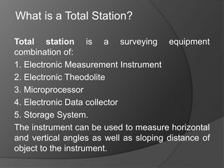
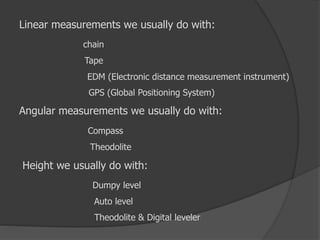
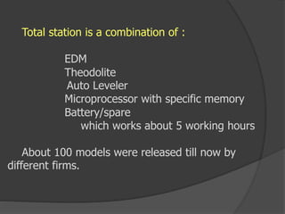
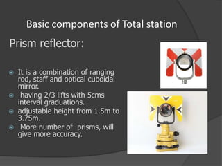
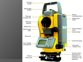
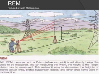
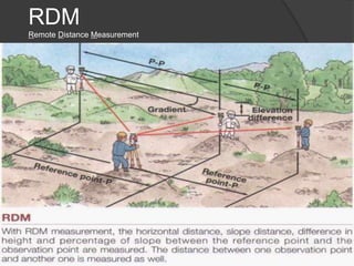
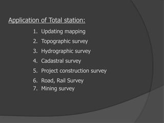
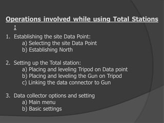
Total station is a surveying equipment
combination of:
1. Electronic Measurement Instrument
2. Electronic Theodolite
3. Microprocessor
4. Electronic Data collector
5. Storage System.
The instrument can be used to measure horizontal
and vertical angles as well as sloping distance of
object to the instrument.
What is a Total Station?
Types of survey
Traverse survey
Triangulation survey
Plane table survey
Which includes:
1. Linear Measurements
2. Angular Measurements
3. Height Measurements
Linear measurements we usually do with:
chain
Tape
EDM (Electronic distance measurement instrument)
GPS (Global Positioning System)
Angular measurements we usually do with:
Compass
Theodolite
Height we usually do with:
Dumpy level
Auto level
Theodolite & Digital leveler
Advantages of Digital levels
 Field work is carried out very fast.
 Accuracy of measurement is high.
 Manual errors involved in reading and recording
are eliminated.
 Calculation of coordinates is very fast and
accurate. Even corrections for temperature and
pressure are automatically made.
 Computers can be employed for map making and
plotting contour and cross-sections. Contour
intervals and scales can be changed in no time.
Capabilities of Digital levels
ď‚— measuring elevation
ď‚— measuring height difference
ď‚— measuring height difference with multiple
instrument positions
ď‚— levelling
ď‚— slope setting
ď‚— setting out with horizontal distance
levelling of ceilings
Total station is a combination of :
EDM
Theodolite
Auto Leveler
Microprocessor with specific memory
Battery/spare
which works about 5 working hours
About 100 models were released till now by
different firms.
Basic components of Total station
 It is a combination of ranging
rod, staff and optical cuboidal
mirror.
 having 2/3 lifts with 5cms
interval graduations.
 adjustable height from 1.5m to
3.75m.
 More number of prisms, will
give more accuracy.
Prism reflector:
•GUN: data screen LCD
eye piece
telescope 24x to 43x
environmental box
microprocessor with memory card of 1 or 2 GB capacity
1MB can store 800 points.
•Tripod: with different material
Aluminum tripod weighs 13 to 14lbs
Wooden tripod will be about 18 lbs.
•Optical and Laser plumb bobs.
•Battery –as an external attachment
with indicators
1.5hours charged battery can work for 3to 5 hours
ACCURACY OF TOTAL STATION
More accuracy can be achieve by :
1. Careful Centering
2. Accurate pointing target
3. Average of multiple points
4. Better optical lenses
5. Strong Tripod
6. Verticality of prism pole
1. Angular accuracy is from 1 to 20 Sec.
2. Linear accuracy is from 2mm to 10mm/per KM
3. Different instruments have different accuracy
Angular
Linear
With 1 Prism With 3 prisms
NIKON 1 Sec + 2 mm + 1 mm
LIEKA 1 Sec + 2 mm + 1 mm
SOKKIA 1 Sec 2 mm + 1 mm
Accuracy varies with Price
Distance measure with:
1.Single Prism – up to 2.5 Km
2.Two prisms - 5 to 7 Km
3.Three prisms - 10 to 12 Km
Functions of T.S:
1. It simultaneously measures angles & distances and
Record
2. Correcting the measured distance
3. Computing the point elevation
4. Computing the coordinates of every point
5. Remote elevation measurement
6. Remote distance measurement
7. Area calculations
8. Data Transferring facility from instrument to S/W
and S/W
to instrument
9. Format of conversion of units
REM
Remote Elevation Measurement
RDM
Remote Distance Measurement
Application of Total station:
1. Updating mapping
2. Topographic survey
3. Hydrographic survey
4. Cadastral survey
5. Project construction survey
6. Road, Rail Survey
7. Mining survey
Operations involved while using Total Stations
:
1. Establishing the site Data Point:
a) Selecting the site Data Point
b) Establishing North
2. Setting up the Total station:
a) Placing and leveling Tripod on Data point
b) Placing and leveling the Gun on Tripod
c) Linking the data connector to Gun
3. Data collector options and setting
a) Main menu
b) Basic settings
4. Creating and Operating Job files:
a) Creating a new Job file
b) Opening an existing file
5. Shooting points
a) Identifying the important points to shoot
b) shooting points
c) Shooting additional points
d) Noting the special features
6.Post Processing – Data down loading, conversion
7.Plotting/Map generation.
Computer software packages
The following post processing computer software
packages are in use for various engineering
applications.
1.Arc Pad, arc view, arc info
2.Micro Station - Map generation
3.Erdas – Image processing s/w
4.Surfer, Auto plotter, Civil cad, Pythagoras
– preparation of contours
5. Survey aid – to draw c/s and l/s
The information received is to be analyzed depending
on the users requirement.
Limitations:
1. It is not a Rugged instrument (Sensitive).
2. Prism verticality is questionable.
3. Visibility is must.
4. More Expensive.
5. Requires standardization at every six months.
6. Amount of error is greater at short distances.
7. Height of instrument and prism is to fix.
8. Awareness on battery maintenance.
9. To establish north- compass is required.
SAFETY PRECAUTIONS
1. Focusing directly at the sun, can result - loss of eyesight
on the spot. Use a filter when observing the sun.
2. Never remove the hand grip carelessly. If the grip is
loosely or incompletely attached, the instrument could fall
and may cause a serious injury.
3. Make sure not to short the battery terminals. If these are
shorted, the resulting high current would not only damage
to the battery, but also start a fire.
4. If the instrument or battery comes in contact with water,
wipe it off as quickly as possible and set it in a dry place
for a while. When it is completely dry, put it back in the
case.
5. Never disassemble the instrument, if you find a problem.
Contact the dealer.
HOW TO SUPERVISE THE TOTAL STATION WORK
 Have keen observation on the prism boy’s attitude. When high precision is
required, use the prism tripod, to avoid human error.
 The position of prism shall always be on hard surface instead of soft soil.
 Focusing shall be exactly at the centre of prism, with the help of cross
hairs and prism plate.
 While measuring the instrument height and prism height, enough attention
shall be diverted. Also, have keen observation while entering the above
data.
 Note the location and coordinates of station point and back sight so that
specified intermediate points can be checked at later date.
 Obtain a soft copy of field work raw data from the survey agency so that
the results can be checked at any time.
 Obtain more number of points to get an average.
Thank
You

Tot.st 1

  • 2.
    Total station isa surveying equipment combination of: 1. Electronic Measurement Instrument 2. Electronic Theodolite 3. Microprocessor 4. Electronic Data collector 5. Storage System. The instrument can be used to measure horizontal and vertical angles as well as sloping distance of object to the instrument. What is a Total Station?
  • 4.
    Types of survey Traversesurvey Triangulation survey Plane table survey Which includes: 1. Linear Measurements 2. Angular Measurements 3. Height Measurements
  • 5.
    Linear measurements weusually do with: chain Tape EDM (Electronic distance measurement instrument) GPS (Global Positioning System) Angular measurements we usually do with: Compass Theodolite Height we usually do with: Dumpy level Auto level Theodolite & Digital leveler
  • 6.
    Advantages of Digitallevels  Field work is carried out very fast.  Accuracy of measurement is high.  Manual errors involved in reading and recording are eliminated.  Calculation of coordinates is very fast and accurate. Even corrections for temperature and pressure are automatically made.  Computers can be employed for map making and plotting contour and cross-sections. Contour intervals and scales can be changed in no time.
  • 7.
    Capabilities of Digitallevels ď‚— measuring elevation ď‚— measuring height difference ď‚— measuring height difference with multiple instrument positions ď‚— levelling ď‚— slope setting ď‚— setting out with horizontal distance levelling of ceilings
  • 8.
    Total station isa combination of : EDM Theodolite Auto Leveler Microprocessor with specific memory Battery/spare which works about 5 working hours About 100 models were released till now by different firms.
  • 9.
    Basic components ofTotal station  It is a combination of ranging rod, staff and optical cuboidal mirror.  having 2/3 lifts with 5cms interval graduations.  adjustable height from 1.5m to 3.75m.  More number of prisms, will give more accuracy. Prism reflector:
  • 10.
    •GUN: data screenLCD eye piece telescope 24x to 43x environmental box microprocessor with memory card of 1 or 2 GB capacity 1MB can store 800 points. •Tripod: with different material Aluminum tripod weighs 13 to 14lbs Wooden tripod will be about 18 lbs. •Optical and Laser plumb bobs. •Battery –as an external attachment with indicators 1.5hours charged battery can work for 3to 5 hours
  • 12.
    ACCURACY OF TOTALSTATION More accuracy can be achieve by : 1. Careful Centering 2. Accurate pointing target 3. Average of multiple points 4. Better optical lenses 5. Strong Tripod 6. Verticality of prism pole 1. Angular accuracy is from 1 to 20 Sec. 2. Linear accuracy is from 2mm to 10mm/per KM 3. Different instruments have different accuracy Angular Linear With 1 Prism With 3 prisms NIKON 1 Sec + 2 mm + 1 mm LIEKA 1 Sec + 2 mm + 1 mm SOKKIA 1 Sec 2 mm + 1 mm Accuracy varies with Price Distance measure with: 1.Single Prism – up to 2.5 Km 2.Two prisms - 5 to 7 Km 3.Three prisms - 10 to 12 Km
  • 13.
    Functions of T.S: 1.It simultaneously measures angles & distances and Record 2. Correcting the measured distance 3. Computing the point elevation 4. Computing the coordinates of every point 5. Remote elevation measurement 6. Remote distance measurement 7. Area calculations 8. Data Transferring facility from instrument to S/W and S/W to instrument 9. Format of conversion of units
  • 14.
  • 15.
  • 16.
    Application of Totalstation: 1. Updating mapping 2. Topographic survey 3. Hydrographic survey 4. Cadastral survey 5. Project construction survey 6. Road, Rail Survey 7. Mining survey
  • 17.
    Operations involved whileusing Total Stations : 1. Establishing the site Data Point: a) Selecting the site Data Point b) Establishing North 2. Setting up the Total station: a) Placing and leveling Tripod on Data point b) Placing and leveling the Gun on Tripod c) Linking the data connector to Gun 3. Data collector options and setting a) Main menu b) Basic settings
  • 18.
    4. Creating andOperating Job files: a) Creating a new Job file b) Opening an existing file 5. Shooting points a) Identifying the important points to shoot b) shooting points c) Shooting additional points d) Noting the special features 6.Post Processing – Data down loading, conversion 7.Plotting/Map generation.
  • 19.
    Computer software packages Thefollowing post processing computer software packages are in use for various engineering applications. 1.Arc Pad, arc view, arc info 2.Micro Station - Map generation 3.Erdas – Image processing s/w 4.Surfer, Auto plotter, Civil cad, Pythagoras – preparation of contours 5. Survey aid – to draw c/s and l/s The information received is to be analyzed depending on the users requirement.
  • 20.
    Limitations: 1. It isnot a Rugged instrument (Sensitive). 2. Prism verticality is questionable. 3. Visibility is must. 4. More Expensive. 5. Requires standardization at every six months. 6. Amount of error is greater at short distances. 7. Height of instrument and prism is to fix. 8. Awareness on battery maintenance. 9. To establish north- compass is required.
  • 21.
    SAFETY PRECAUTIONS 1. Focusingdirectly at the sun, can result - loss of eyesight on the spot. Use a filter when observing the sun. 2. Never remove the hand grip carelessly. If the grip is loosely or incompletely attached, the instrument could fall and may cause a serious injury. 3. Make sure not to short the battery terminals. If these are shorted, the resulting high current would not only damage to the battery, but also start a fire. 4. If the instrument or battery comes in contact with water, wipe it off as quickly as possible and set it in a dry place for a while. When it is completely dry, put it back in the case. 5. Never disassemble the instrument, if you find a problem. Contact the dealer.
  • 22.
    HOW TO SUPERVISETHE TOTAL STATION WORK  Have keen observation on the prism boy’s attitude. When high precision is required, use the prism tripod, to avoid human error.  The position of prism shall always be on hard surface instead of soft soil.  Focusing shall be exactly at the centre of prism, with the help of cross hairs and prism plate.  While measuring the instrument height and prism height, enough attention shall be diverted. Also, have keen observation while entering the above data.  Note the location and coordinates of station point and back sight so that specified intermediate points can be checked at later date.  Obtain a soft copy of field work raw data from the survey agency so that the results can be checked at any time.  Obtain more number of points to get an average.
  • 23.